Category Archives: History

Part 3: Misericords in the Chester-Wrexham area – Miracles, myths, demons, and the occasional grin

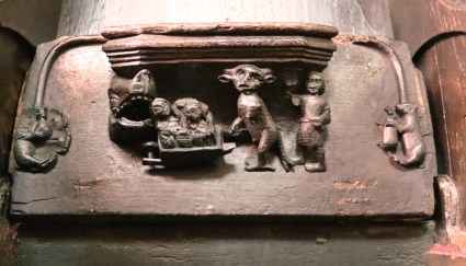
Creature wheeling two women in a barrow towards a hellmouth. All Saints’s Gresford

Apologies that it has taken a couple of weeks for part 3 to appear.  The subject is so massive and it seems impossible to do it justice in a blog post but eventually that big, accusing Publish button just has to be clicked 🙂

Part 1 introduced misericords and described some of the themes captured in the choir of St Werburgh’s Abbey (Chester Cathedral).  Part 2 described the misericords at Gresford, Malpas and Bebington.  This 3rd and final part addresses who might have been responsible for the themes chosen, who may have paid for the misericords, why they were contained within the most sacred part of the church and how they might be understood.  Finally I have added some visiting details for the cathedral and the three churchs, plus a list of references for all three parts.

Selecting the misericords

How were the topics selected and by whom; who carved them; and who paid for them?

How themes were selected

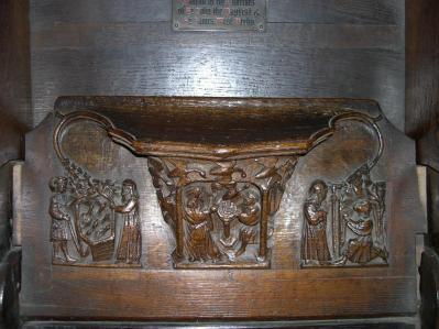
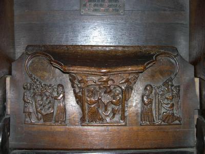
Scene showing in both the main scene and the supporters St Werburgh’s miracles. Source: Dominic Strange, World of Misericords

Each misericord showed a different subject matter, and whether there were 48 (as at Chester) or 14 (as at Gresford) there could be great diversity in the themes selected.  The patron saint of an abbey or church might dictate the subject matter in a single misericord, like the miracle of St Werburgh at Chester, but this accounts for only one misericord of any one corpus.  Some themes are commonly found throughout misericord collections and are evidently part of a popular repertoire or corpus of themes.  As Anderson says in his survey of gothic art, “The subjects of misericords did not have to be consistent, so any good design, from whatever source it came from, could be used on them,” but particular themes and ideas were probably favoured in each different establishment, leading to a different character and ambience from one set to another.  The enthusiasm for certain themes will have changed over time, reflecting both popular and intellectual fashions, but all were chosen from similar types of source material.

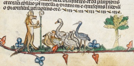
Folio 49v from the Smithfield Decretal showing a fox, with mitre and crozier, preaching to a flock of birds. Source: British Library

Manuscripts were an obvious source of ideas.  Bestiaries such as the beautiful MS Bodley 764, referred to in parts 1 and 2, provided a wealth of ideas, as did travelogues. Both Old and New Testaments, missals and hagiographies (biographies of saints, often at least partly fictional) were also alternative sources.  The Golden Legend by Jacobus de Voragine in the 13th century was a particularly popular account of the lives of saints, which even today is a good read.  The marginal scenes shown on various religious illuminated manuscripts including psalters (books of psalms) and books have hours (personal books for private worship) probably supplied others, which included so-called drolleries and grotesques.  The Luttrel Psalter and the Smithfield Decretals are good examples.  Contemporary chivalric romances, popular narratives and collections of stories like the 14th century French Cy Nous Dit (which contained versions of the tales of Tristan and Isolde, Alexander carried over the edge and the exploitsof the knight Yvain – all of which are at Chester) were good sources of stories with a moral thread. Towards the end of the Middle Ages it has been demonstrated that some themes were inspired by woodcut images that were circulating in Europe following the success of the printing press in the mid-15th century.

Image and supporters copied from earlier examples. The model for the central image was first carved at Lincoln in the 1370s (top), then reproduced with much more gusto and exuberance at St Werburgh’s Chester in the 1380s (middle) and finally, with much less energy than either, at St Mary’s Nantwich in the 1390s (bottom). All sourced from Christina Grössinger, The World Upside-Down, p.47 (see Sources at end)

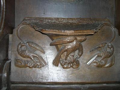
Carvers almost certainly brought ideas with them from other abbeys, cathedrals and churches, which they could share with their new employers.  Some topics are clearly copied from one ecclesiastical establishment to another, probably introduced by carvers who moved to new building projects as they became available.  Sixteen designs in Chester were based on those from Lincoln, and six in the the impressive parish of St Mary’s church in Nantwich, were copied from Chester.  The herons on a misericord in St Werburgh’s, for example, were very nearly clones of a misericord at Lincoln Cathedral, although the supporters are different.  An even more striking example is a crowned head with wild hair and beard, flanked by two heads in profile. This appears first in Lincoln Cathedral, then at St Werburgh’s Abbey in Chester.

Although St Werburgh’s may have been expected, by virtue of its proximity, to have provided the inspiration and basic model for the later examples at Gresford, Malpas and Bebington, none of the misericords are copies of surviving Chester examples.  There are indeed shared themes, but there are no attempts at replication.  This suggests that in each case the choices made drew on other sources for their ideas, perhaps reflecting the time gap between the Chester and later misericords, or otherwise reflecting local choices or preferences.

———
———–
Who would have been involved in the choice of themes?

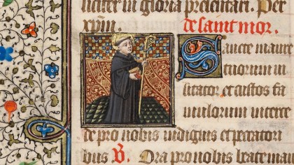
Abbot with staff and book. MS. Ludwig IX 6 (83.ML.102), fol. 222v. Source: Getty Museum

It is not known exactly how the topics depicted on individual misericords were chosen, but there are a number of possibilities.  At an abbey or independent priory, the superior (abbot or prior) and the senior personnel may have dominated the decisions, but individual monks from the larger monastic community may have contributed to the selection process too.  External patrons, whose financial input would have been necessary for a project on the scale of the Chester quire are likely to have wanted to contribute to their own favoured themes.  In a parish church both the senior clergy and the bishop would probably have dominated the decision process, but external, private financial contributors such as local landowners may also have had a vested interest in the selection of themes.  Multiple sources of finance, each perhaps buying a vote in the selection process, would help to explain the diversity of the subject matters chosen both within a single choir, and the differences from one church to another.

It is sometimes suggested that misericords were the brainchildren of the craftsmen who carved them, indulging themselves with creative and sometimes (to the Victorian mind) off-colour designs without any direct input from the clergy.  Being confined to the choir in the most sacred part of the church, however, it seems unlikely that anything could have been selected and installed without the permission of a head cleric, such as the abbot in the abbey, or a parish priest (or his bishop) in a church.  It also seems implausible that an abbot or bishop would sit back and allow expenditure to be used unchecked on fantastic frivolities that would have to be accounted for to both superiors and inferiors alike.  Although carvers probably suggested certain popular themes based on their own experience, the misericords and their themes must have been sanctioned at the highest levels.

Who carved the misericords?

Stained glass portrait, thought to be Master Carpenter Hugh Herland. Source: Upchurch Matters

Remarkably little is known about the wood carvers who created these remarkable vignettes.  For prestigious projects carvers seem to have moved from building to building.  Christina Grössinger identifies a single London workshop as having been responsible not only for the Chester and Lincoln wood-carvings, but also for those that at St Katherine’s in Stepney (London) and the former Carmelite friary in Coventry.  John Harvey had formerly identified the hand of famous Master Carpenter Hugh Herland, who worked on a number of royal and prestigious college projects in the 14th century, at Lincoln and particularly Chester, but Grössinger rejects this suggestion, and a quick look at Herland’s list of responsibilities for the decades in which the Lincoln and Chester misericords were made (1370s and 1380s respectively), suggests that he was probably far too busy on prestigious works elsewhere to oversee these two projects as well.  Present in Chester between 1377 and 1411, however, was William Newell the king’s chief carpenter who was probably involved with the work on the choir, at the very least in an advisory capacity.  For a Benedictine monastery like St Werburgh’s it was important not merely to raise the status of the individual abbey, but to contribute to the prestige of the Benedictine order as a whole, particularly in a period when monastic orders were becoming much less influential in society and politics.  Whoever was responsible for overseeing the project, many carpenters will have contributed to the misericords and canopies, and both the designs and the work are certainly exquisite.

St Andrew’s, Bebington

The preference for the most prestigious carvers available in the country suggests that where prestige was important and the finance available, only the best carvers would do and could be hired from places at considerable distance from the institution concerned.  The impressive churches of Malpas, Gresford and Bebington would not have had the same scale of financial resources, nor the same ambitions for national prestige reached for by the abbot Chester abbey, but quality was still important.  Carvers were more likely to have been sourced closer to home, but even so the skills required may still have required importing specialists to oversee and ensure high quality. In his paper on the carvers of the Oxford colleges, Gee says that during the 14th century the pay for a Master Carpenter, was around 4d monthly.  For a nationally recognized and prestigious Master Carpenter of whom the above-mentioned Herland is an example, this rose to around 1s. There was therefore a wide scale of pay for different levels of skill and creativity.  work.

Who paid for them?

Canopies above the choir stalls in Chester Cathedral

Elaborate choir stalls with misericords were luxury items for a church, raising the prestige of the incumbent clergy and the establishment as a whole either nationally for an abbey or cathedral, or regionally for a collegiate or parish church.  They were, in functional terms, unnecessary but for some monasteries and churches, the investment may have been important for institutional and social reasons, reinforcing the position of the church in the wider community at a time when ecclesiastical influence was in decline.  Status and vanity projects always come with a substantial bottom line, and the funds would have been acquired from a number of different income streams and one-off sources.

A monastic establishment like St Werburgh’s might have any number of income streams. The Benedictines, the longest established monastic order of the Catholic tradition in Britain, had been endowed with enormous estates and resources.  Monasteries were amongst Britain’s greatest landowners, owning huge swathes of the rural landscape.  This level of royal and significant magnate  investment had trailed off by the early 1300s, so monastic establishments were forced to make the most of the property they already owned and attempt to secure smaller but still significant bequests and investments, and one-off donations for special projects.  Ongoing sources of funding included tithes (funds appropriated from churches that it adopted), the often impressive output of produce sold from a network of monastic farms, private bequests in wills, and contributions by living benefactors.  Appropriating churches, and securing their income, was increasingly important throughout the later medieval period.  Chantries were also an excellent source of income for urban monasteries.  These were financial foundations set up by individuals to pay for an ordained monk, or several monks, to recite multiple prayers for himself/herself after death, as well as for his or her family and ancestors;  These were invaluable income-generators for monasteries.  Pilgrim shrines could also be very lucrative for monasteries with appropriate relics, particularly if they were reputed to perform miracles.

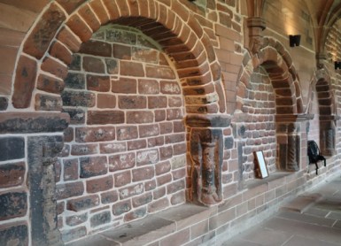
Probable burial places of some of  the medieval abbots in the cloister at St Werburgh’s, Chester

The abbot and monks themselves, might contribute to prestigious projects.  Although the earliest Benedictine monastic orders had been based on vows of poverty, and the reforming orders of the late 11th and early 12th centuries renewed these vows and intentions, by the late 14th century the Benedictine monks had lost their ambition for poverty, and were  rarely self-effacing.  Although it was a particular thorn in the side of Henry V in the early 15th century, abbots and their monks might well be considerably wealthy in their own right.  This was in spite of St Benedict’s proscription against the ownership of private property in the Rule on which the Benedictines were supposed to base their monastic lives.  An abbot’s subordinates too might have access to personal wealth. To ensure his own personal legacy an abbot of an important urban monastery might invest in a prestigious project that, in the case of St Werburgh’s included not only the choir stalls but the elaborate and intricate canopies above.  The abbot would probably be able to secure contributions from his community of brethren as well, and would certainly attempt to secure donations from beyond the cloister.  For those both within the community and those outside it, there was the hope that by contributing their mite to the glorification of God, they might serve less time paying for their sins in purgatory.  Even where in-house monastic funding was available, the gifts of patronage might be important to  elaborate monastic improvement, and for a project as immense as the St Werburgh’s quire, significant investment would have been welcome.

In an urban environment although there might be additional opportunities for securing funds, there might be competition with other establishments.  For example, St Werburgh’s charged for burials within its cemetery, and was in competition with other ecclesiastical establishments in Chester to secure those payments.  However, there was a particular prestige to being buried in a monastic context, and more importantly the possibility of being as close as possible to the divine.  Any wealthy Chester resident who wanted to be buried within the of the abbey precinct, and particularly the abbey church itself, would have to pay a very steep price for the privilege.

Elaborate and costly wood carving on the screen at the entrance to the choir at All Saints’ Gresford.

Perhaps more intriguing are the sources of the investment for the three parish churches.  These might also include tithes, which were a type of tax due from every household to fund the parish church (in the form of produce for much of the Middle Ages), if there was any surplus remaining after the clergy had been paid and church costs defrayed.  Another form of income were chantries that were set up in parish churches as well as monasteries, particularly the more prestigious parish churches.  These too might provide an income from which a surplus could be saved for special projects.  A more promising source of sufficient funds for a  was likely to be bequests and donations made by a number of particularly wealthy benefactors and patrons, either individuals, families or organizations.  For parish, collegiate and cathedral churches crowd-funding by the congregation might have been a possibility. Although most of the congregation was excluded from the chancel, (within which the choir was located), Nicholas Orme makes it clear that wealthy and influential parishioners, as well as choristers, might be given access.  These more privileged members of the congregation would have access to any work within the chancel to which they contributed either large one-off gifts or piecemeal funding, even if they were not primary benefactors or members of founding families.  It is also possible that access to the chancel was an incentive for anyone who had the money to invest in ecclesiastical projects.  Access to the chancel, and burial within its confines, were highly desirable as this was the closest that most people would come to the divine prior to death.  If the parish priest was independently wealthy, he too much contribute to the costs, as might the bishop.

Little of the abbey church survives at Basingwerk

A different possibility is the purchase, wholesale or piecemeal, of the misericords from another building.  If an abbey or priory church went out of use, a set of choir-stalls might become available for purchase at a fraction of the price of commissioning a new set from scratch.  A parish church with wealth of its own, or with patrons who wished to make a mark, might benefit from the unexpected windfall.  The Dissolution of the Monasteries under the reign of Henry VIII from 1535 to around 1540 liberated many church furnishings for purchase by less exalted establishments.  In Lancashire, for example, choir stalls from Whalley Abbey found their way into a local parish church, whilst in Lancaster itself the misericords may have come from a nearby Premonstratensian establishment.  There has been a suggestion that the Gresford misericords might have been sourced from Basingwerk Abbey at Holywell following its 1535/1536 dissolution.  However, the impressive Monastic Wales research portal states that the choir stalls from Basingwerk actually went to St Mary’s on the Hill in Chester, presumably complete with misericords, a claim echoed in the ChesterWiki page for the church (but unsupported by any citation) as part of a general refurbishment. I have not seen the original sources and their arguments for either proposal.  If the stalls were once at St Mary’s on the Hill they are not there now.  Gresford All Saints’ seems, anyway, to have had both the ambition and the funds if it wished to comission its own choir stalls during the 15th century when the church was substantially remodelled.
———

The role of misericords

A sense of meaning

All Saints’, Gresford

In spite of the genuinely fascinating and academically impressive work carried out on the subject, there are no definitive answers about how a corpus of misericords is best understood.  There is so much variety and as Gombrich observes, for some of these images “[t]here are no names in our language, or categories in our thought, to come to grips with this elusive dream-imagery in which ‘all things are mixed’. . .  It outrages both our ‘sense of order’ and our search for meaning.”  The overtly religious themes on some misericords are accompanied by far less obviously appropriate scenes including on the one hand horror, myth, fantasy and the monstrous and, on the other hand, humour, farce, ribaldry, Colish’s “red thread” of satire and, perhaps, some very early forerunners of schadenfreude and even burlesque.  Misericords are one of the few ecclesiastical contexts in which the lower echelons of society can be observed. The acrobats at Gresford have already been mentioned in Part 2, and entertainers and sports of various sorts are common.

St Werburgh’s Abbey, Chester

In spite of the difficulties it is irresistible to try to address some of the questions.  For example, why was highly irreligious imagery, some of it very funny, included in the most sacred of ecclesiastical spaces? Why were naked human private parts, women beating men, foxes lecturing geese, upright cats, writhing dragons, strange beasts, wildmen and ugly monsters shown side by side with, on the one hand, lowly peasants and jesters and, on the other hand, saints, angels, kings and heraldic symbols of the nobility?

Whilst parts 1 and 2 demonstrated how individual misericords can successfully communicate certain stories and convey specific ideas, an entire corpus of misericords is rather more interesting as a sum of the various parts, presumably containing somewhere within it the religious, ideological and cultural motivations, the very heart of why these carvings existed in the first place.

A framework for living

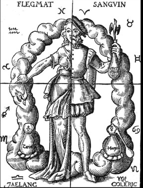
Alchemic approach to four humours in relation to the four elements and zodiacal signs. Book illustration in “Quinta Essentia” by Leonhart Thurneisser zum Thurn (gen. Leonhard Thurneysser). Source: Wikipedia

From today’s perspective, the world of the Middle Ages encompassed a very different set of experiences, and this has to be factored into any attempt to understand medieval imagery.  These many challenges of the Middle Ages were understood within a descriptive and explanatory framework that helped to give a sense of order.  As well as the overarching structure provided by Christianity, there was a framework for neatly organizing existence into manageable chunks.  The natural world was divided into four primary elements: air, fire, earth and water, with air opposite earth and water opposite fire.  The human body was divided into four “humours,” and the human condition was divided into four “states.”  All were characterized in terms of heat and moisture, and were influenced by both the four seasons and the 12 astrological points of the zodiac.  In Christian terms, the presence of the devil and his demons, the reality of purgatory and hell, and even the performance of saintly miracles were all aspects of a world that for most people, were a reality in which the supernatural was entwined with the everyday.  Structuring the world in this complex way formed a model for understanding it and operating within it.

There were also less structured but equally useful mechanisms for coping with a life in which more nebulous anxieties and worries did not fit neatly within the conventional framework.  The supernatural had its own role, which did not always dovetail smoothly with other explanatory models.  Superstition, the rumblings of magic and divination and the presence of evil in the dark corners of the supernatural all had a role to play.

The realities of medieval life

The central theme of this misericord is a two-bodied monster with a single head. The supporters are also monsters, their tails connecting them to the misericord.

Everyday life in the later Middle Ages, and the 14th century in particular (the century in which the Chester misericords were carved) was hard. The 14th century was not merely a matter of political change and social unrest, but incorporated the Great Famine of 1315-17 the arrival of the terrible Black Death of 1348-1350, and the recurrence of plague outbreaks in 1361-2, 1369, 1374-9 and 1390-3 during which thousands of people died and entire villages were permanently abandoned, and following which economic challenges inevitably occurred.  Other notable events included the relocation of papal power from Rome to Avignon in 1309; the Ordinances of 1311, which imposed limits on Edward II’s power;  Robert de Bruce’s defeat of Edward II at Bannockburn in 1314; a period of political and military turmoil followed by Edward II’s forced abdication and probable murder in 1327; Scottish independence in 1328; the beginning of the 100 Years War in 1337 under Edward III, which brought with it periods of purveyance and heavy taxation; the 1341 parliamentary crisis; the 1351 Statue of Labourers (Edward III’s attempt at wage-fixing); the death of Edward III in 1377;  the Papal Schism of 1378; John Wycliffe’s anti-Catholic writing (inspiring his Lollard followers) and his vernacular English editions of the Bible in the mid to late 14th century; the Peasants’ Revolt of 1381; and the removal of Richard II from the throne in 1399.  For Cheshire and northeast Wales, the appointment of Edward III’s son the Black Prince as Earl of Chester in 1333 and Prince of Wales in 1343 were also particularly relevant.  A great many more dates could be added to this brief and selective list, but this is probably sufficient to highlight the social and political turbulence of these decades.  The late 14th century misericords in British monasteries and churches, with their often threatening and subversive themes may say as much about social anxiety as spiritual fervour.

Lion fighting a dragon flanked on each side by a wildman (wodehouse), one riding a wyvern and the other killing some form of dragon-like creature. St Werburgh’s Abbey, Chester

Writing about the monsters, hybrids, wildmen and grotesques populating the margins of the Luttrell Psalter (dating to the 1320s-30s), Michelle P. Brown could also be commenting on the 14th century misericords when she says:  “They reflect the neuroses of a society in flux, one rightly concerned in the face of political corruption, international warfare, civil war, famine and demographic decline.”  Some of these anxieties and concerns are translated into analogous images on the misericords, which became vehicles for representing the extreme aspects of both familiar realities and potential realities that link life as it is lived and the “other.”  Here the familiar meets the unfamiliar in the liminal, teetering right on the edge of the unknown beyond where mermaids, dragons, wyverns, unicorns, strange humanoid beings and the unknown lurked.  These territories on the edges and margins of observable reality are places of high risk, where strange beings and actions are not only possible but plausible.

This was obviously not a simple matter of juxtaposing conventionally opposing ideas like saints-and-angels versus devils-and-demons.   In the medieval period the there was a recognition of the border spaces between the sacred and the profane, the religious and the domestic, a blameless life and a misspent one, good and evil, life and death, death and rebirth.  This in-between existence is space that is neither hell nor purgatory and might act as a reminder that between this world and that occupied by the divine, there was significant uncertainty.

Bearded man at St Andrew’s, Bebington. Source: Dominic Strange, World of Misericords

Although the unusual, the mythical and the allegorical stand out, ordinary people may also be represented.  They do not feature prominently at either St Werburgh’s or Gresford’s St Oswalds, where most of the original misericords are present, but ordinary people occur on misericords outside the Chester area.  The obviously religious themes interlock with scenes of everyday life, some allegorical, some empirical, some scurrilous. Michael Camille suggests that misericords are like the Mystery plays in that they allow “anecdotal details and the depiction of social manners” including folk stories and fables and scenes of domesticity and seasonal activities.  The inclusion of peasants engaged in hard work, such as those shown in the Labours of the Months, (the most complete example of which is at a church in Ripple, Worcestershire, shifted there from Whalley Abbey after the Dissolution) may represent a dependence on the annual cycle, but may equally capture the nature of the social order itself, with saints at the top and serfs at the bottom, all equally important at least in God’s eyes.

Woman as a tornado of anger with cowering man, flanked by two very cross characters. Chester St Werburgh’s

As Grössinger says, however, most of the everyday people shown on misericords are engaged not in the domestic realm or in serious pursuits, but in “a subversive view of everyday events that can both entertain and teach.”  These depictions include acrobats, contortionists, hunting, wrestling, feasting, brawling, bear-baiting and music making.  When ordinary people begin to behave in a challenging way, there may have been a great deal of unease about the reality of God’s creations humans being less than perfect specimens who were unable or unwilling to use free will for good.  Misericords depicting women beating men, foxes preaching to geese,  gymnasts displaying their private parts, may well represent the use of derision and humour to mediate the uncomfortable realities of everyday social discord, another aspect of the subversion of an idealized view of life.  This was perhaps just as true of medieval creative thinking as it is of today’s, and ties in with an explanatory framework in which both monsters and monstrous behaviours were part of God’s creation, and should be included in any understanding of reality as it is perceived and the liminal areas beyond our immediate vision or geographic location.

The lovers Tristan and Isolde. St Werburgh’s, Chester

Heroic, chivalric and romantic tales bear testimony to the rewards of idealized behaviour in the face of such challenges, but clearly comment too on the risks confronted by good people who encounter evil, temptation and other dangers.  These narratives offer approaches to handling danger and mechanisms for defeating fear and the fearsome.

Interestingly, the misericords do not tend to focus on the image of death itself and only rarely give death a voice, unless it is to remind the onlooker of Christ’s sacrifice for humanity.  Demons, hell and people being delivered to the hellmouth are certainly represented, but these are more a threat to the living, teetering on the edge of the abyss, than a characterization of death itself.  Depictions of skeletons, the personifications of death,  fairly unusual, even in the 15th century when the Danse Macabre (and John Lydgate’s derivative Dance of Death) and cadaver monuments, and in particular transi tombs, became popular.

Fox preaching to cockerel and geese. All Saints’, Gresford

Finally, there is always the matter of tradition.  Whilst the 14th century misericords at places like Lincoln, Chester and Nantwich may have been a response to the difficulties of the times, it is quite likely that much later misericords were seen more in the light of a connection with the historical integrity of the church, the honouring of an ecclesiastical tradition and a form of validation of more modern works, as well as a resistance to ecclesiastical change, by reference to the past.

Why were carved misericords incorporated into sacred spaces?

View of the choir from steps to the central altar, Gresford All Saints’. The carved screen divides the sacred space of the choir, the choir-stalls and the misericords from the public nave beyond.

In a church the choir is divided from the long nave, where the congregation gather, by a screen.  Perhaps the dangerous and threatening was best contained and restricted within the choir, where religious rituals were concentrated, and where the clergy and monks could contemplate and learn from the disruptive and unsettling scenes before (and under) them.  It must have been accepted at some point that the inclusion of irreverence and crudity sitting alongside religious themes had a useful role and would not, most importantly, be offensive to God.  If the themes were essentially a coping strategy consisting of fashionable morality tales and derisive warnings against bad behaviour, such forms of expression probably needed to be safely contained, segregated from those who might misinterpret them and retained for the benefit of those who could contemplate them and understand their role.  Acknowledging risk and conceptualizing it in the form of margins and misericords was a way of bringing a wit and energy to the unknown world of the “other” that sat beyond the edges of medieval life, but it was not suitable for everyday consumption.

One of the Victorian replacements at Chester St Werburgh’s showing one of Aesop’s fables, the fox and the stork.

It is worth remembering that at least in the context of monastic establishments and collegiate churches, and probably in the greater majority of the parish chancels, the choir was the domain of men alone.  It is all too likely that the more risqué of these themes were considered far too warm and witty for delicate female sensibilities and, in the majority of cases, for their inferior intellects too.  Confining such scenes to the choir would normally guarantee an exclusively male audience.

Context:  Themes that reflect the misericords in other forms

Delightfully grotesque creature, one of many clinging to the walls of All Saint’s, Gresford. Its beautifully chosen red sandstone skin against the pale yellow masonry makes it particularly ghastly!

Very briefly, where misericords are found, it is worth having a look around to see what other types of similar imagery may exist both within the church and on the exterior.  The subject of architectural gargoyles and related grotesques has already arisen on this blog in connection with Gresford All Saints’ church, where the twisted, deformed, ugly and bizarre look down on gathering congregations and passers by, marching in sequence along the string-course, spewing out water, or apparently poised to pounce from window corbels and string courses. There was no limit to medieval imagination, and the exteriors of many medieval churches display some of the most extraordinary and creative monsters anywhere in the late medieval world.

Pilgrim and bench end, St Werburgh’s Abbey, Chester

Interior imagery includes choir-stall arm rests, bench-ends and bench-end carvings and sculptural components such as corbel supports. In some big ecclesiastical establishments the ceiling bosses and vaulted arch corbels are also used to capture the mythological, the fantastic and the entertaining.  Camber bream ceilings may be accessorized with sculptural components in wood or stone where the ceiling beams meet the walls.  Baptismal fonts sometimes display elaborate imagery, and where original medieval floor tiles remain, these too often display images and symbols.  Medieval stained glass, where it survives, although better known for its display of the great and the good sometimes captures subjects from the margins.  These may or may not be contemporary with misericords, but add to the story that successive generations of clergy and congregations could read in their place of worship.

Together, all these carved forms, whether in wood or stone, formed a complex ecclesiastical world in which miracles, judgement, purgatory and the apocalypse were the stuff of fact, and in which saintly shrines channelled divine power, and where the unregulated performance of domestic solutions were probably manifestations of harmful superstition and demonic magic inspired by the devil.  The messages of risk and uncertainty, coped with by following Christ’s example and ameliorated by belief in the love of God, were carried throughout the church, inside and out.
xxxxxxx

Final Comments

Over the three posts in this small series I have barely touched the surface of what misericords meant to churches and their clergy and why they merited their cost.  That is partly because the topic is so rich and the corpus in Britain alone so massive.  There have been many attempts to get to the root of what the misericords, in each corpus, are intended to do, what role they are designed to perform.   It is possible in each place to pick out key themes in misericords, including religious and miraculous scenes; domestic, seasonal and everyday activities; kingly and knightly pursuits and adventures, many of them referencing popular chivalric romance and courtly love; the fantastic, monstrous, mythical and legendary; and the seriously crude and scatological.  The medieval interest in the “other” is very conspicuous.

All Saints’, Gresford

Misericords did not shy away from even the most bawdy elements of human existence, challenging the binary, recognizing the complexities of Christian lives.  Rather than simple black and white contrasts of good versus evil, the misericord vignettes capture an entire kaleidoscope of social and cultural perception and commentary.  It does not matter in which order the overall message is read, but it does matter that it incorporates a deeply felt form of reality beyond the immediately observable, which may offer both opportunity and risk.  Whether amusing, tender or shocking, misericords have the ability to tell a moral tale, carrying real impact in their didactic role, encouraging introspection and self-awareness.

Arm rest. St Andrew’s, Bebington

Between life as it was lived every day, the the supernatural as it was imagined, and those strange foreign lands and invisible realities with with strange monstrous beings, there was plenty to worry medieval people.  These are sources of potential anxiety and stress that paid no respect to social standing.  Misericords represent the diversity and unending variability of living things and their experiences, both natural and supernatural along the entire continuum of human and divine life.   Although sometime based on stories captured in manuscripts, and sometimes loose copies of paintings and prints from northwest Europe, the misericords have a voice of their own.  Approaching them as embodiments of layered meaning can add depth and richness to each individual piece, but they are equally appealing for their visual splendour, and can be appreciated simply for their beauty, mischief, boldness and charm.

Visiting (as of December 2023)

The layout of the choir stalls and description of their misericords. Source: Stephen Smalley 1996 (see “Sources” at end)

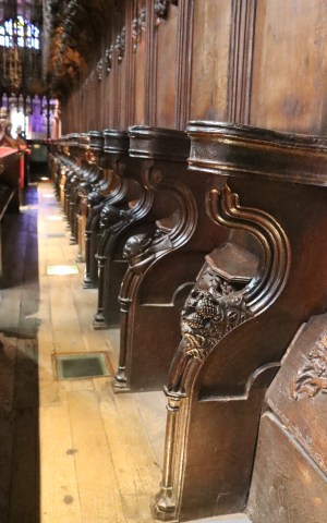
On my multiple visits to Chester Cathedral in 2022 and 2023  the misericords have usually been available to view.  Although they are sometimes roped off, particularly when an event is upcoming, you can usually go between the lower choir benches to lean over and see some of the misericords, and there are usually cathedral staff around to ask if you can get a little closer.  On my visits to Gresford and Malpas, the misericords were accessible to view when the church was open to visitors and not being used for services and events.  St Andrew’s in Bebington can only be visited by appointment (see below) but again the three misericords are on unrestricted display.

None of the locations have obligatory entry fees, but Chester always has someone at its reception requesting a voluntary donation into a big perspex box (or by swiping a debit/credit card).  There is also a gift shop and very good café in the former abbey refectory, which is a wonderful space in its own right.

Swordplay. St Oswald’s, Malpas

Gresford, Malpas and Bebington do not have reception staff, but as village churches they are even more in need of voluntary donations.  Given how beautifully these churches are maintained, it is well worth giving them support.

Gresford All Saints’ and Malpas St Oswald’s are still open for services, weddings and funerals, as well as community activities, but are generally also open daily for visitors. You can park outside All Saints’ on the road.  At St Oswald’s it is better to find the car park, just five minutes away, and walk.

Bebington St Andrew’s is only open for Sunday services and other formal events, and visiting is by appointment only.  My thanks to the office for making arrangements for me to visit.  I’ll be writing up the entire church on another occasion.  There is plenty of parking on the road when the church is not in use for services, weddings etc.

I have included the What3Words location for those with the app installed (it works beautifully with the free Google satnav).  Check the individual websites for services, opening times and other details:


Sources

My thanks again to Dominic Strange and his World of Misericords website for allowing me to use so many of his images. He is an absolute star, and his website is a fabulous resource, one of the best examples of how websites can really contribute to research projects.

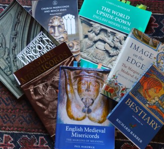
Each of the three posts in this short series was originally a lot longer, and some of the references below relate to those chunks that I cut out, but in case the full bibliography is of interest, I’ve left it unaltered.  I have not managed to track down all the references that I might have found of use, so there are gaps.  If you are looking into misericords and want the references that I have noted down for future reference but have not used here, just let me know and I will email them over.

Books, booklets and papers

Anderson, M.D. 1954. Misericords. Medieval Life in English Woodcarving.  Penguin

Anderson, M.D. 1971. History and Imagery in British Churches. John Murray.

Asma, Steven T. 2009. On Monsters. An Unnatural History of Our Worst Fears. Oxford University Press

Avilés, Alejandro García 2019.  The Visual Culture of Magic in the Middle Ages.  In (eds.) Sophie Page and Catherine Rider. The Routledge History of Medieval Magic. Routledge, p.402-431

Barber, Richard. 1992. Bestiary. MS Bodley 64. The Boydell Press

Baxter, Ron. 1998. Bestiaries and their Users in the Middle Ages. Sutton Publishing
https://www.researchgate.net/publication/340870845_Bestiaries_and_their_Users_in_the_Middle_Ages_Sutton_Publishing_1998_ISBN_0_7509_1853_5

Bench end “poppy head,” Gresford All Saints’

Beal, Timothy K. 2002. Religion and Its Monsters. Routledge

Bennett, Carol. 2015. Lincoln Cathedral Misericords and Stalls in St Hugh’s Choir.  Lincoln Cathedral.

Bildhauer, Bettina. 2003. Blood, Jews and Monsters in Medieval Culture. In Bildhauer, Bettina and Mills, Robert (eds.), The Monstrous Middle Ages.  University of Wales Press.

Bildhauer, Bettina and Mills, Robert. 2003. Introduction: Conceptualizing the Monstrous. In Bildhauer, Bettina and Mills, Robert (eds.), The Monstrous Middle Ages.  University of Wales Press

Broughton, Lynne. 1996. Interpreting Lincoln Cathedral: The Medieval Imagery. Lincoln Cathedral Publications

Brown, Michelle, P. 2006. The World of the Luttrell Psalter. The British Library

Burne, R.V.H. 1962. The Monks of Chester. The History of St Werburgh’s Abbey. SPCK.

Camille, Michael. 1992. Image on the Edge. The Margins of Medieval Art. Reaktion Books

Chunko Betsy L. 2011. Vernacular Imagery on English Misericords:  Framing Interpretation. St Andrew’s Journal of Art History and Museum Studies, 2011, vol.15, p.5-12
https://ojs.st-andrews.ac.uk/index.php/nsr/article/download/255/264/

Clifton-Taylor, Alec. 1974. English Parish Churches as Works of Art.  B.T. Batsford Ltd.

Colish, Marcia L. 1997. Medieval Foundations of the Western Intellectual Tradition 400-1400. Yale University Press

Davies, Owen. 2012. Magic. A Very Short Introduction. Oxford University Press

Dickinson, John. 2008. Misericords of North West England.  Their Nature and Significance. Centre for North-West Regional Studies, University of Lancaster.

Fry, Nick. 2009.  Chester Cathedral.  Scala

Fudgé, Thomas. 2016.  Medieval Religion and its Anxieties.  History and Mystery in the Other Middle Ages.  Palgrave Macmillan

Gee, E.A. 1953. Oxford Carpenters 1370-1530. Oxoniensia, vol 17-18, 1952-3, p.112-184

Gombrich, E.H. 1979, 1984. The Sense of Order. A Study in the Psychology of Decorative Art. Phaidon Press Ltd.

Green, Richard Lancelyn (revised by Roberts, Alan) 2018. St Andrew’s Bebington. St Andrew’s Heritage Committee

Greene, J.Patrick. 1992.  Medieval Monasteries. Leicester University Press

Grössinger, Christa. 2007.  The World Upside-Down. English Misericords.  Harvey Miller Publishers

Hardwick, Paul. 2011. English Medieval Misericords. The Margins of Meaning. The Boydell Press, Woodbridge

Hardwick, Paul. 2017. Chaucer’s Friar John and the Place of the Cat. The Chaucer Review, 52(2), p. 237-252

Harte, Jeremy 2003. Hell on Earth: Encountering Devils in the Medieval Landscape. In Bildhauer, Bettina and Mills, Robert (eds.), The Monstrous Middle Ages.  University of Wales Press

Harvey, John. 1947. Gothic England. A Survey of National Culture 1300-1550. B.T. Batsford

Hiatt, C. 1898. The Cathedral Church of Chester.  A Description of the Fabric and A Brief History of the Episcopal See.  George Bell and Sons. Available on the Internet Archive

Jones, Bethan. 1997. All Saints Church Gresford. ‘The Finest Parish Church in Wales’. The Friends of the Parish Church of All Saints Gresford.

Jones, Malcolm Haydn. 1991. The Misericords of Beverley Minster: A Corpus of Folkloric Imagery and its Cultural Milieu, with Special Reference to the Influence of Northern European Iconography on Late Medieval and Early Modern English Woodwork. Unpublished PhD thesis.
https://pure.plymouth.ac.uk/ws/portalfiles/portal/38446601/303331.pdf

Laird, Marshall. 1996.  English Misericords. John Murray

Luxford, Julian. 2005. The Art and Architecture of English Benedictine Monasteries, 1300-1540. A Patronage History. Studies in the History of medieval Religion Volume XXV. The Boydell Press

Orme, Nicholas. 2021. Going to Church in Medieval England. Yale University Press

Page, Sophie. 2017. Medieval Magic. In: Davies, O, (ed.) The Oxford Illustrated History of Witchcraft and Magic, Oxford University Press, p.29-64

Riches, Samantha J.E. 2003. Encountering the Monstrous. Saints and Dragons in Medieval Thought. In Bildhauer, Bettina and Mills, Robert (eds.), The Monstrous Middle Ages.  University of Wales Press.

Rider, Catherine. 2012. Magic and Religion in Medieval England. Reaktion Books.

Roberts, Alan. 2018. St Andrew’s Bebington. Church and Churchyard Tours. St Andrew’s Heritage Committee

Ryands, T.M. (no date). An Illustrated History of St Oswald’s Malpas.

Smalley, S. (with additional research, Fry, S.) 1996. Chester Cathedral Quire Misericords. The Pitkin Guide. Chester Cathedral

White, Carolinne. 2008. The Rule of Benedict. Penguin.

Williams, David. 1996.  Deformed Discourse. The Function of the Monster in Medieval Thought and Literature. Liverpool University Press.

Woodcock, Alex. 2018 (2nd edition). Of Sirens and Centaurs.  Medieval Sculpture at Exeter Cathedral. Impress Books

Websites

All Saints’ Church, Gresford
https://www.allsaintschurchgresford.org.uk/about-us/our-history/

Bodleian Library
MS Bodley 964 (Bestiary)
https://digital.bodleian.ox.ac.uk/objects/e6ad6426-6ff5-4c33-a078-ca518b36ca49/

British History Online
Chester Cathedral – A History of the County of Chester: Volume 3. Originally published by Victoria County History, London 1980, pages 188-195
https://www.british-history.ac.uk/vch/ches/vol3/pp188-195

The Camelot Project, University of Rochester (New York)
The Legend of Yvain.  By Dongdong Han, 2010
https://d.lib.rochester.edu/camelot/text/han-the-legend-of-yvain

Clwyd and Powys Archaeological Trust
Church of All Saints, Gresford (although note that this has no mention at all of the misericords)
https://cpat.org.uk/Archive/churches/wrexham/16785.htm

Internet Archive
Liber monstrorum. A translation of the Old English text. By Andy Orchard, taken from Pride and Prodigies: Studies in the Monsters of the Beowulf Manuscript, University of Toronto Press; 2nd ed. edition (19 April 2003)
https://web.archive.org/web/20050118082548/http://members.shaw.ca/sylviavolk/Beowulf3.htm

The Medieval Bestiary. Animals in the Middle Ages
https://bestiary.ca/

The National and University Library Slovenia
The Elaborate Details in a Medieval Manuscript. Treasures of the National and University Library of Slovenia
https://artsandculture.google.com/story/the-elaborate-details-in-a-medieval-manuscript-national-and-university-library-of-slovenia/aAXhCkz6RxgiIw?hl=en

San Francisco State University
Ywain and Gawain. (Editors: George W. Tuma, Professor Emeritus of English, and Dinah Hazell, Independent Scholar, hosted by the English Department, San Francisco State University)
https://www.sfsu.edu/~medieval/romances/ywain_gawain_rev.html

St Oswald’s Church, Malpas
https://www.malpaschurch.co.uk/st-oswalds-malpas/

Princeton University
The Elaine C. Block Database of Misericords
https://ima.princeton.edu/digital-image-collections/collection/block/intro

World of Misericords
https://www.misericords.co.uk/ by Dominic Strange

Misericords in situ within choir stalls at St Werburgh’s Abbey (Chester Cathedral)

A visit to The National Waterways Museum at Ellesmere Port

Although quite literally freezing cold, the sun was stunning yesterday so on the spur of the  moment, having just run an errand to Rossett, I plotted a route to the National Waterways Museum at Ellesmere Port on the Wirral.  It’s very easy to find, being just off the M53.  I have been meaning to visit ever since I moved to this area.  It is one of those places best done in dry weather, because there is as just as much, if not more, to see outside as indoors.  Visitor information details are at the end.

Background History

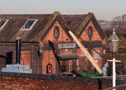
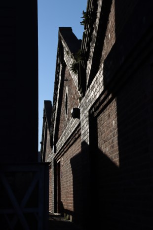
The museum occupies the 19th century canal and port complex, re-using the lovely brick-built buildings for exhibits and displays and using sections of the docks and basins for a number of fascinating canal and waterway vessels.   Ellesmere Port was the largest Inland Waterway dock complex in the United Kingdom.  The name Ellesmere Port refers to the town of Ellesmere, where many of the decisions about the Shropshire Union canal network were made.  There was no Ellesmere Port until the port was established in 1796 as a small base at the Mersey end of the Shropshire Union Canal.

The Shropshire Union Canal was one of a number of canals built at different times which, in 1846, were amalgamated into a single operational network.  The earliest part of this network was the Nantwich to Canal section.  The earliest part of the system was the Chester Canal which ran from Chester to Nantwich in 1772.  It was not until 1793 that a section connecting Chester to the Mersey was built, with its terminus at Ellesmere Port.  The section from Nantwich to Birmingham, the Birmingham and Liverpool Junction Canal, was the main north-south artery of this network, and was not completed until 1835, joining the national canal network for which Birmingham was the central hub.

By 1802 as well as a series of locks with a lock keeper’s house, there was also three basins, wet and dry docks, a small wharf, a clerk’s house and a canal lighthouse.  Over subsequent decades additional wharves were added and warehouses, workshops and sheds were built.  A scheme by Thomas Telford for a dock and entrance for seagoing vessels was completed in 1843, significantly improving the port’s suitability for transhipping.  During the 1850s the most important cargo was iron, followed by ceramics from the Potteries, and substantial facilities were provided for both.

The opening of the Manchester Ship Canal in 1894, and the simultaneous improvement in facilities at Ellesmere Port significantly improved the prosperity of the port.  Unfortunately this was something of a swansong for the canal port, and In 1921 the Shropshire Union Canal Company sold its fleet of barges and the commercial viability of the canal and the port for freight handling came to an end.  The railways replaced the canals throughout Britain, with many of the former wharves and ports falling into disuse and dereliction. Ellesmere Port managed to survive until the 1950s and became a museum in the 1970s.

More details of the history of the port, (together with some of the business and industries it attracted, the development of the surrounding settlement and details of the drainage of Stanlow marshes by German prisoners of war in the First World War), are available in Vince Devine and Jo Clark’s excellent survey (see Sources at end).

The Museum

The derelict port buildings became a museum in the 1970s after a heroic effort by a group of volunteers, and is now a conservation area with nineteen Grade II listed buildings.  It was originally known as the North West Museum of Inland Navigation and had various other names until it became The National Waterways Museum, with its emphasis on inland waterways, both rivers and canals, although coastal vessels are also included.  As well as boats and exhibition and display spaces, the site is also home to the Waterways Archive, and education centre, conference facilities, a shop and café and other amenities, all located within the port buildings.

Map of the museum. Sorry it’s a bit crumpled, but there does not appear to be a clean version online. Click image to expand.

Entrance is via the ticket office that sits between the shop and the café.  There is a 5 minute video to watch if required, and then access to the rest of the museum is on the other side of the shop, which sites on the side of the canal entrance to the port.  There were obligingly two narrowboats moored further up the quayside, hemmed in with ice, and this is a very good place to orientate oneself with the help of the excellent map that comes with your entry ticket.   It’s quite a complicated site, with several buildings containing exhibits, so the map is invaluable.

I started out by walking over the bridges towards the Exhibition Hall, former warehousing, taking in some of the historic boats moored up alongside the quays in the Upper Basin.

The big former warehouse, called the Island Warehouse, has displays on two floors.  The ground floor is a vast collection of objects connected to the waterways, including bits of engine, windlasses, tillers, rudders, sack barrows, buckets and lamps and a zillion other objects, parts and bits.  There’s very little information on display, although a QR code promised more details about some of the objects via your smartphone (I had left mine in the car by accident).

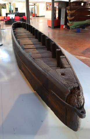
A really wonderful find on the ground floor was a long glass cabinet containing a prehistoric log boat found in Baddiley Mere in Cheshire, and made of a single, hollowed-out trunk of oak.  This is a nationally important object and it was splendid to see it.  I had no idea it was at Ellesmere Port.  Sadly, the cabinet was hemmed in on all sides with other objects. It was also covered in dust and the glass sides reflected the surroundings, so it was difficult to get close or see it properly and impossible to photograph well.  I do wish that it was on the first floor exhibition area, where it could be seen and appreciated properly.  According to the Heritage Gateway website, it is on loan from the Grosvenor Museum.

The prehistoric log canoe, which could be rather more conspicuously and sympathetically displayed.

—————-

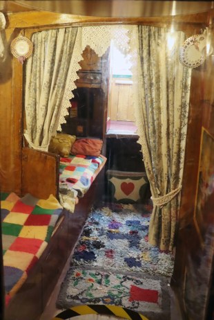
The first floor is a more formal exhibition area.  There is a cut-away narrowboat called Friendship with its painted bow and stern and a tiny little cabin, the unimaginably small living quarters of the narrowboat’s operator and his family.  A delightful pleasure boat, the 1954 Amaryllis, glows with glossy mahogany and polished brass.  My favourite was an example of a long, slender boat called a “starvationer,” designed to run on the 46 miles (74km) of subterranean canal tunnels in the Duke of Bridgewater’s Worsley coal mines.  Other cabinets have model boats and ships showing a range of different types and sizes.  A couple of cabinets have examples of canal art associated with narrowboats.  Items commonly found in the dock and canal port are included.  There’s even a working model of the Anderton Boat Lift.  Information boards provide plenty of detail.

A “starvationer”

Sack chute

Out on the other side of this building, back outside, there are more boats.  Some of the boats that are usually out in the summer are under cover for winter, still visible but not as accessible.  This is particularly true of the valuable wooden narrowboats like Gifford and the ice-breaker Marbury.  Being under cover, they are also easier to work on.  The ongoing care and repair of wooden boats is a major part of the out of season work at the museum, and there information boards explaining what is being done to each.

The ice-breaker “Marbury”

Walking to the left, a splendid ship hull rests in a giant covered cradle, the remains of the Mersey flat barge Mossdale. According to the signage she is the only surviving all-timber Mersey flat.  She was initially named Ruby, in which guise she carried cargoes of up to 70 tons, towed by steam tug on canal, river and along the coast.  In spite of her flat base she was very stable. She was sold in 1920, after which she carried pottery, grain, flour and sugar along the Bridgewater canal.

Mossdale

Beyond this is the splendid Pump House with its 69ft (21m) chimney built in 1873.  This was closed to the public on the day I visited.

Heading back, the next place to visit is Porters Row, four terraced houses, each one fitted out with furniture, accessories, wallpaper, technology and kitchen equipment that would have been found in dock workers’ homes of the 1830s, 1900s, 1920s and 1950s.  This is such fun, a really evocative way of getting a sense of how past objects were deployed in ordinary homes, although some were clearly more prosperous than others, one with a piano, and more remarkably one with a organ!

Beyond and downhill (reached via a ramp, or by locks if you are in a boat) is the Lower Basin containing more boats, with the rather well disguised Holiday Inn hotel beyond.

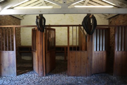
Crossing to the other side of the port, there is another set of buildings that includes the old stables (for the horses that pulled the unpowered narrowboats), the blacksmith’s forge (still operational), and the Power Hall, which is a display of ship engines, one of which can be operated via a push-button.

FCB18 – a barge made of concrete

On the other side of the Power Hall are two more boats, one of which, the barge FCB18, is fascinatingly made of concrete, which is a crazily counter-intuitive concept. But there it is, happily afloat.  The information signage says that she was built in 1944 during the war, which was a time of steel shortage.  Concrete was readily available and cheap, and although steel was still required, only 18 tons was required, as opposed to the 56 for a steel barge with a carrying capacity of 200 tons.  Unfortunately, the resulting barge was heavy, difficult to steer, and brittle.

The other boat is Basuto, looking like something built of rusty Meccano, but again, still afloat in a sea of green weed.

Back up towards the exit is a sign pointing you to the slipway with its blue-painted wooden winch house, and from here you can see over to the channel that connects the Manchester Ship Canal to the River Weaver and Ellesmere Port.  When you leave the museum, you can turn left along the road that passes between the museum and the car park, and walk along the channel’s edge towards the Holiday Inn, where there are some great swing bridges and more canal-side buildings, including a unique port lighthouse.

The above is just a sample – there’s lots to see.  A great visit.

Visiting Information

A dry day is preferable for a visit, because there is a lot to see outside, and the buildings themselves are part of the attraction.  Opening times are on the Canal and River Trust website here.  At the time of writing (January 2024) the entrance fee was £11.75 for an adult, which seems quite steep but the ticket lasts for a year, and I will certainly be making use of mine for another visit.  Other entrance fees are on the museum’s website on the above link.  There is a nicely presented shop with books, toys and canal-themed ornaments, and a bright, comfortable café.  Outside there are plenty of picnic benches, and a play area.  The museum was amazingly quiet.  Given the bright sunshine I thought that it would be fairly busy, but the cold was obviously a deterrent, the docks being frozen solid.

I was warned at the ticket office about icy surfaces, which takes on a particular resonance when you are walking along the edges of frozen expanses of water with almost no-one around.  But they had done such a good job with the salt and grit that even in the cold shadows there was no ice on which to slip.

For those with unwilling legs, there are ramps nearly everywhere.  In the Island Warehouse there is an elevator to the first floor, but this was out of order when I visited so it might be a good idea to phone first if you need it.  There is a lot to see on the first floor, so it would be best to go when the elevator is working.  The Pump House was closed, but this appears to be accessible only via a short flight of steps (5 or 6 steps).   Otherwise, as far as I could see, the whole site seemed to be fully accessible for wheelchair users and those with unwilling legs.

Boat trips are available in the summer.


Sources

Books and papers

Vince Devine and Jo Clark. 2003.  Ellesmere Port Archaeological Assessment. Cheshire Historic Towns Survey
http://www.cheshirearchaeology.org.uk/wp-content/uploads/2013/06/HTS_Arch_Assess_EllesmerePort.pdf

Websites

The Ellesmere Port Canal Port Trail
The Mersey Forest
https://www.merseyforest.org.uk/things-to-do/walks-bike-rides-and-more/walks/ellesmere-port-canal-port-trail/

The Shropshire Union Canal
The Canal and River Trust
https://canalrivertrust.org.uk/canals-and-rivers/shropshire-union-canal
Virtual Tour of the Museum
https://canalrivertrust.org.uk/things-to-do/museums-and-attractions/national-waterways-museum-ellesmere-port/virtual-tour-of-the-national-waterways-museum

History of the Shropshire Union Canals
The Shropshire Union Canal Society
https://shropshireunion.org.uk/shropshire-union/early-history-of-the-shropshire-union-canals/

Postcard of a photograph from the museum archives. Lovely to see all those Fellows, Morton and Clayton narrowboats lined up. A real canal legend.

Part 2: Miracles, myths, demons and the occasional grin: Misericords in the Chester-Wrexham area

Gresford All Saints’

In Part 1 of this 3-part series, the subject of misericords in choir stalls was introduced, the four churches covered in this three-parter were identified, and the St Werburgh’s Abbey (Chester Cathedral) misericords were discussed.  Part 2 takes a look at the misericords in the smaller churches of Gresford All Saints’, Malpas St Oswald’s and Bebington St Andrew’s.  References for all three parts can be found at the end of Part 3.

——–
Chester, Gresford, Malpas and Bebington (continued)

Basic data about the misericords at the four churches

The misericords carved for St Werburgh’s Abbey (Chester Cathedral) were discussed in Part 1.  All Saints’ church in Gresford, St Oswald’s at Malpas and St Andrew’s in Bebington were considerably more modest in scale than St Werburgh’s Abbey, but all were impressive when measured against other parish churches in the region, and obviously had access to relatively substantial funding.  The table above was also posted in part 1 and provides some of the vital statistics of all four sets of misericords.

All Saints’, Gresford

All Saints’ Church in Gresford

All Saints’ Church in Gresford is unexpectedly big for such a small and unimposing village.  The stone church was founded in the 13th century and underwent a major revamp in the 15th century, and is still busy today. I have written about All Saints’ on two previous posts, one about the history of the church in general, and the other about the 15th century gargoyles and grotesques that inhabit its exterior.  It has been suggested that the misericords were sourced from Basingwerk Abbey at Holywell in north Wales and added to All Saints’s after the abbey was dissolved in the early 1500s, but although this remains a possibility, it is also probable that All Saints’ was sufficiently well provided for to pay for its own misericord carvings.

Choir stalls at Gresford All Saints’

Neither the All Saints’ guidebook nor the CPAT survey suggest a date for the misericords, and the church’s web page does not mention them.  Based on the presence of a preaching fox, a theme thought to represent mendicant friars who were only present from the 14th century, they must have carved after the late 14th century.  It is also very probable that they post-date those at St Werburgh’s (1390) as there was nothing else nearby to provide a model.  Although the Gresford misericords could plausibly have been associated with the major rebuild of the church in the 15th century, when two new aisles were added and many other changes were made, Dominic Strange’s misericord timeline places the misericords in the late 15th or early 16th century, over 100 years after the Chester misericords.  If correct, it demonstrates the durability of themes that were popular in earlier periods.

Sketch plan of the Gresford misericords.

The choir stalls provide a good example of a three-sided arrangement in a squared U-shape.  In total there were originally fourteen misericords, four on the north, four on the south and two lots of three on the west.  The latter flanked the entrance from the nave to the choir.  Today two are blank, either because they were never completed, or because they were removed due to inappropriate content or severe damage (I can find nothing to help determine which).  Some are quite badly damaged, but the entire group indicate great skill and include some varied topics.

The choir, Gresford All Saints’

The misericords are separated by arm rests that curl up the sides of the chairs and along the backs, each one featuring a small human figure at the front of the arm rest.  Exceptions are at the corners between the north and west rows and the west and south rows, which feature fantastic beasts.

As in St Werburgh’s, a fox is dressed as a friar but this time he is in a pulpit preaching to chickens and geese, demonstrating that this theme was of interest not merely to monastic establishments but to churches as well.  The allegedly venal of some elements of the mendicant cause may be the theme here. The earliest mendicant friars were poor and itinerant, begging for alms.  By the later middle ages they were comfortably established in friaries of their own, the recipients of patronage, gifts and wills. The apparent hypocrisy was a source of grievance for the clergy beyond the seclusion of the cloister.  The parish priest may also have felt threatened by the powerful public sermons and the more evocative style of engagement with the general public delivered by the friars.  In the parish church, as well as in the heart of the monastery, friars might be seen as a threat to the role of the conventional clergy, to be satirized, derided and, if possible, undermined.

One of the more puzzling themes that occasionally appears on misericords (but is missing from Chester, possibly due to removal in the Victorian period) is the revealing of male nether regions. At Gresford this is given a context.  The misericord shows an acrobat hanging over a pole held by two men, ostentatiously exposing his undercarriage, apparently during a performance, possibly a form of slap-stick entertainment.  Quite what these were doing on misericords is uncertain, although there is a lot of speculation on the subject.  Whilst there may have been a warning against lewdness and impurity, it is difficult to deny that at least some of these depictions were intended to include a degree of crude humour.

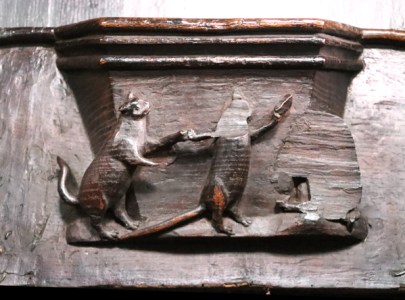
A badly damaged misericord shows two cats, both standing on their hind legs in front of something that is now missing but appears to show a mouse hole at the base, with a tiny mouse with pointed ears to its right.  The cats are holding hands, with one apparently leading the other.  The leading cat seems to have been holding something in its outstretched paw.  Perhaps the upright stance reflects the cat’s commanding, self-possessed and often self-satisfied view of its position within its own universe.  An alternative interpretation is that when animals are shown adopting human behaviour, it is a reminder of human failings.  Similarly standing on their hind legs are the cats in MS. Bodley 764 (folio 50r), which also shows cats on the hunt.

Cats from MS Bodley 764, folio 50r. Source: Medieval Bestiary

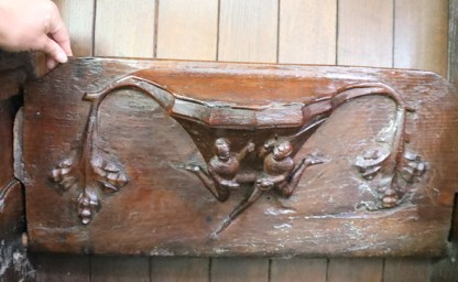
Wheelbarrows feature quite frequently in misericords, and one of the Gresford misericords shows two women seated side by side in a wheelbarrow being pushed towards the open jaws of a monster’s head by a creature with staring eyes and a forked tail.  The cavalcade is followed by a man.  All the participants in the scene stare out at the onlooker.  The open jaws of the monster represent the gateway to hell.  This is a much simpler version of a well-known example at St George’s Chapel, Windsor Castle, which shows two monks being wheeled towards the hellmouth by either a demon or the devil himself, leading to the suggestion that the two wimpled women on the Gresford misericord may be nuns (but bearing in mind that wimples were not exclusive to nuns).  The supporters appear to be small rodents, but it is difficult to see how they might relate to the central narrative.

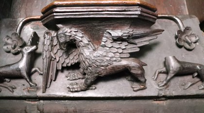
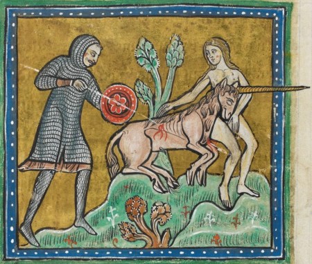
A splendid winged griffin, facing left, is positioned between two delicate unicorns, one of which is missing its head. The griffin has the head and wings of an eagle, the body of a Lion and is four-legged.  Like the lion, which can exert its power for either good or evil, depending on the context.  When Alexander the Great encounters the enclave of griffins in his voyage to the end of the world, the creature is a true monster, ugly, frightening and vicious.  On the other hand it is a pair of griffins that carried Alexander over the edge of the world.  The griffin is often used to represent rival ideas and can, in different contexts, represent such opposing individuals as Satan and Christ.  The griffin also represents the combination of the opposing elemental forces of air (eagle) and earth (lion).  It is difficult to know what, in this context, the griffin is intended to convey.  The presence of unicorns, which are often associated with Christ, may either be supportive companions, opposing forces, or hapless victims, and there is nothing to help determine which. The supporters are decorative flowers.

Another misericord, also quite unlike its companions, seems to refer to the gargoyles and grotesques so strongly featured on the exterior of the building.  It may have had no specific symbolic meaning.  It is a monster’s face with vaulting emanating from its head.  The vaulting may be intended to evoke the magnificent screen that separates choir from nave at All Saints’, although the flowers at the intersections on the misericord are not present on the screen. Perhaps it is intended to bring indoors the collective message that the gargoyles and grotesques were communicating from the exterior of the church (discussed briefly in an earlier post).

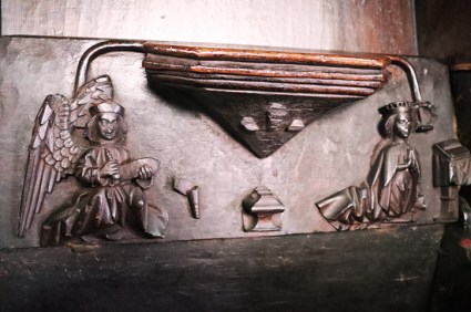
Some of the All Saints’ misericords are very badly damaged, leaving the core subject matter very difficult to identify.  A particularly frustrating example is the misericord whose central subject matter is completely missing.  Flanking it there is a wonderful winged angel on the left and, on the right, a lady in an elaborate dress kneeling before a personal altar with the soft folds of her dress flowing behind her on the floor.  Perhaps this was either the Annunciation or the Coronation of the Virgin, particularly as there are no other overtly religious stories included in the All Saints’ corpus.

Another badly damaged misericord shows a woman on a four-legged animal, the head of which is missing and is therefore unidentifiable.  It is short, has particularly bandy legs and ill-defined feet, none of which suggest a horse.  Two carvings, one in front of the woman and animal, and one behind, are lost.  The one behind is almost certainly another figure in a long garment, but the one in front may or may not be.

Some of the misericords contain no narrative or obviously symbolic component.  One misericord has no central subject matter and no obvious sign of damage, with just two images as supporters, right on the edge of the underside of the seat.  These are two three-quarter partial heads, almost sketches, looking towards one another.  The meaning of this, if there was any, is lost.  If there was a central carving, there is not even a shape left to suggest a subject matter.  It is possible that it was carved at a much later date to replace one of the original misericords that might have been damaged or whose subject matter was considered inappropriate.  These lost stories are very frustrating.

All of the misericords at Gresford are shown on the World of Misericords website at https://www.misericords.co.uk/gresford.html, with short descriptions at https://www.misericords.co.uk/gresford_des.html.

St Oswald’s, Malpas

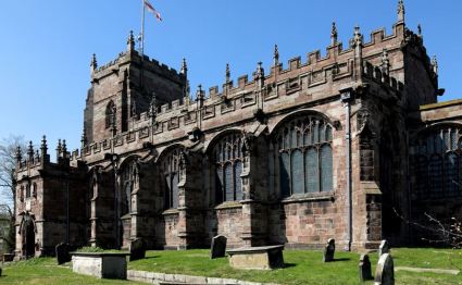
St Oswald’s Church in Malpas. Photograph by Alan Marsh. Source: Historic England

St Oswald’s Church in the village of Malpas was founded in the late 1300s.  The church underwent a similar modernization in the 15th century to that at Gresford, including a similar camber beam roof.  It has a great many features that continue to impress, particularly the spectacular tomb effigies of the 15th and early 16th centuries, but its remaining misericords are disappointingly confined to three choir stalls.

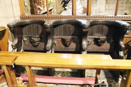
There is a set of three choir stalls with three misericords, in a single row, still displayed in the choir area in St Oswald’s.  The visitor guide to the church says that there were “at least twelve” 15th century choir stalls with misericords, with only nine surviving and six “much restored.”  Given that there are only three on display, it is something of a puzzle as to what happened to the remaining six of the nine surviving.  There are no descriptions of any of the misericords, and nor does the booklet say where the surviving misericords (other than the three still in the choir at Malpas) are located today.

The remaining row of choir stalls at St Oswald’s with the misericords hidden beneath the seats.

The choir stalls have carved armrests, although they less elaborate than those at Gresford, and have no carved bench ends.  This may suggest that carved choir stalls were never a very important component of the chancel at St Oswald’s, or that the funds required for a more ambitious project were not available.  All three remaining misericords are described here, with the disclaimer that they represent only a very small sample of the original corpus.  Two of the three are damaged.

I particularly like the mermaid.  Mermaids appear on many misericords in Britain.  Mermaids resembled Greek sirens, representing both the temptation and lust that men might find hard to resist on the one hand, and the dangers represented by the deformation of the human image in the form of a hybrid creature on the other.  They were usually shown, as at Malpas, with bared breasts, with a comb in one hand and a mirror in the other, warnings not merely of seduction but of the vice of vanity.  The Malpas mermaid looks down and seems to be moving gently to her right.  Her tail has been lightly carved to suggest fish scales. Her bare chest is distinctly flat and smooth, unlike most misericord mermaids, perhaps to avoid encouraging carnal thoughts amongst the Malpas choristers.  She holds the comb  in her left hand, which rests on her thigh (separated from her upper arm by breakage), and the mirror in the other, overlapping one of the supporters.  Both supporters are three-lobed leaves.

A winged monster has one head, shown facing outward, but two bodies that are shown in profile either side of the head.  This is probably the simplest and least worked of all three, with minimal details carved into the image, although there are shallow markings to suggest the scaled nature of the wings, and clawed feet.  The face is shown in more detail, with three protrusions from the head, which may or may not depict serpents.  It is clearly a monster with affinities like the wings, tails and claws that are shared with dragons. Dragons, wyverns and related monsters may represent paganism, power, uncontrolled violence or lust, the Devil himself and unspecified evil and sin that must be confronted and neutralized, or at the very least rationalized.  As such creatures are usually associated with remote, often hostile landscapes, they may also represent fear of the unknown.  It may also offer a shifting geographical component, so that the dragon may be feared in the remote landscape but is only confronted when it threatens human habitation and safety. The three-lobed leaf supporters are nicely done, with clearly defined edges.  A much more elaborate version of a single-headed and double-bodied monster is shown in the Luttrell Psalter (folio 195v), but is evidently part of the same family of images familiar and available to medieval illuminators, carvers and sculptors.

Single-headed two-bodied monster from the Luttrell Psalter (Add MS 42130 f.195.v). Source: Groteskology

Finally, two knights are shown engaged in an athletic, almost balletic fight with swords. Of the three this is by far the most complex, compositionally.  At first glance it is very difficult to see exactly what is going on, and whose limbs belong to whom, vividly capturing movement.  The pointed shoes, generally confined to the well-to-do, emphasize the mobility and athleticism of the figures.  Perhaps it refers to a scene from a chivalric romance, such a the Chester examples that show scenes from stories of Yvain and Tristan and Isolde. Again, the supporters are foliage.

St Andrew’s, Bebington

St Andrew’s, Bebington

As I was just about ready to hit the Publish button on this post I had a whizz through Dominic Strange’s Timeline and Gazetteer, which revealed that St Andrew’s in Bebington on the Wirral possesses misericords in three choir stalls, plus two that have survived being separated from their choir stalls, now serving as corbels.  Although the church is not open except for Sunday services, weddings etc., Karen from the church office very kindly arranged for me to visit when volunteers were working there.

Choir stalls in St Andrew’s, Bebington

It is particularly nice to have found these misericords because, as with St Oswald’s in Malpas, the misericords at St Andrew’s rarely appears in books about misericords, always overshadowed by Chester Cathedral and Gresford All Saints’.  It is clear that they should be included here not only because they are local and under-sung but because they show some themes that are not shown in the misericords at the other locations discussed in these posts.

The pelican in her piety

Dominic Strange places all five misericords in the 15th century.  The guidebook to the church, by Richard Lancelyn Green, says that there were originally twelve of them, with six surviving until 1847 when they were split up due to damp and dry rot.  Presumably the other six were discarded.  Initially, in 1871, they were split into pairs and then, in 1897, three of them were reassembled into the row that survives today in the chancel, just to the side of the main altar. Two of them have been removed from their original choir stalls and are deployed as corbels but there is no mention of the sixth 1847 survivor.

At the far left of the choir stall is the pelican in her piety plucking her breast (shown above), already described in connection with Chester in part 1, but flanked here with foliage.

Bearded man. Source: Dominic Strange, World of Misericords

The head of a man with beard and hat or other form of head covering may or may not be a portrait.  Many misericords show human faces, some characterized by particular expressions or actions, but many contain no clues about the significance.  The supporters feature pomegranates.  Pomegranates are associated with numerous ideas from antiquity onwards.  The symbolism attached to them ranges from fertility, regeneration and good luck to representing the shedding of the blood of Christ and as a symbol of the church and its congregation.  Without knowing quite what the man’s head represents it is difficult to interpret the entire message of the misericord.

The third in the row is a splendid dolphin flanked by equally splendid seahorses, presumably designed by someone who had seen neither dolphin or seahorse. The dolphin is a rather terrifying looking creature, but there seem to be no negative narratives associated with it. The bestiary in MS Bodley 764 includes the dolphin, but attaches no special meaning to it, stating that “they follow men’s voices, or gather in shoals when music is played . . . if they go in front of the ship, leaping in the waves, they appear to foretell bad weather.”  The only other misericord dolphins that I’ve seen in my online travels are at Norwich Cathedral and St Laurence’s Church in Ludlow.

The remaining two misericords, now used as corbels, show what may be a bull’s head, and a sow with a litter.  You can see them on the World of Misericords website.  The sow with a litter is a theme also featured on one of the St Werburgh misericords.  MS Bodley 764 is quite clear on the negative connotations:  “The sow that was washed and returns to her wallowing in the mire is filthier than before; and he who weeps for his admitted sins, but does not desist from them, earns a graver punishment, condemned by his own misdeeds which he could have prevented by repentance; and he descends as if into murky waters because he removes the cleanness of his life by such tears, which are tainted before the eyes of God.”  Sows represent unclean spirits and are often associated with gluttony and, more disturbingly, heresy.  And in the medieval mind, where heresy lurks, paganism may be lurking nearby.

Contributors to knowledge

Even in such small numbers, the churches at Malpas and Bebington contribute to the body of information about Medieval misericords, helping to build up a database of knowledge about the themes that were of interest to those who commissioned them for the most sacred parts of their monasteries and parish churches.  Unless an early report describing or illustrating some of the other misericords emerges, the legacy of those who commissioned, funded and carved the misericords at Malpas and Bebington are confined to just these three and five examples respectively.  Although the themes were represented elsewhere, none of the topics shown replicate any of those surviving at St Werburgh’s.

Other churches in the region with misericords

Grapevine misericord at Nantwich St Mary’s. Source: Dominic Strange, World of Misericords

The above are the only churches with misericords in the Wrexham-Chester area, but there are others in the general region.  For example, there is a set of fourteen dating to the late 14th century in St Mary’s Nantwich to the east, in the town centre.  There are 20 dating to the late 15th century in St Asaph’s Cathedral to the west in north Wales. Another set of sixteen dating to the late 15th century can be found in St Bartholemew’s in the village of Tong to the southeast (where the A41 meets the M54).  Finally, there are two fine sets of 15th century misericords (the first of sixteen in 1425 the second of twelve in 1447) in St Laurence’s church in Ludlow.

The distinctive Nantwich examples can be seen on Dominic’s World of Misericords, as can those at St Asaph’s, but the Tong ones have yet to be added to the site, and I cannot find images of more than one or two of them elsewhere.  There is a section of the Ludlow Palmers website dedicated to the St Laurence’s misericords in Ludlow, and you can see sixteen of them on World of Misericords.

Next

Part 3 wraps up the series, looking at who was involved in the creation of misericords, how they were paid for, and why they featured so frequently in the most sacred part of a church, often hidden from view but containing a mixture of messages that in each case contributed to the sense of a church’s identity.  Visitor details and references are also added at the end of part 3.


Miracles, myths, demons and the occasional grin: Misericords in the Chester-Wrexham area #1

Introduction

I first encountered the fabulously inventive misericords, an integral part of some church choir stalls, in Chester Cathedral, founded as St Werburgh’s Abbey.  At the abbey they were installed in the late 14th century, and in all cases, from the late 12th to the early 16th century the choir stalls were located in the holiest section of a church, where sacred liturgies and rituals were performed.

Two choir stalls from St Andrew’s Bebington. On the left the hinged seat is in the down position, hiding the misericord beneath. On the right, the seat is tipped up, leaning on the seat back, and reveals the carved misericord on the underside of the seat (my photo Creative Commons licence CC BY-NC-ND 4.0)

Misericords are hinged wooden seats set into the choir stalls.  When folded down to provide seating, the seat has a plain, flat surface, but when folded up to rest against the seat back, a small platform on the underside of the seat allows the standing chorister to rest his rear end.  The word misericord derives from the Latin misericordia (mercy or pity) and for the tired or aged monk or chorister looking for some respite for weary and arthritic legs, it probably was mercifully welcome.

The central theme of this misericord is a two-bodied monster with a single head. The supporters are also rather wonderful monsters, the one on the right also a double-bodied creature, the one on the left possibly a wyvern (Chester Cathedral, my photo Creative Commons licence CC BY-NC-ND 4.0)

In some cases, these misericords were decorated with elaborate carvings.  They are flamboyant, skilfully carved and conceptually clever, covering a variety of themes, with individual scenes capturing a seemingly bottomless pit of information about medieval ideas, anxieties, beliefs and even humour.  They consist of a central scene and two “supporters.”  The central scene is the main subject matter, and the supporters may relate to it, but may simply perform the job of ornamental complements.  Although many western European countries also display misericords, the supporters are a British feature.  The earliest misericords known in Britain date to the 13th century, with the most complete examples being at Exeter and Salisbury.

The themes of misericords may be religious, mythological, fantastical, domestic, seasonal, humorous, crude and even scatological.  Unlike gargoyles, and the figures on arm rests and bench ends, which are individual sculptures, the misericords often make up quite complex scenes, and may be have a narrative component.  Particularly skilled carvers produced sophisticated forms and structures which not only engage the viewer but stand out as works of art in their own right.  Whilst some were evidently intended to amuse or surprise, others were layered with meaning, creating galleries of real character and adventure.

Canopies above the choir stalls in Chester Cathedral (my photo Creative Commons licence CC BY-NC-ND 4.0)

Misericords, just one component of the choir stalls, are usually accompanied by carved arm rests and often magnificent bench-ends, and in the wealthier establishments sit beneath elaborate canopies, as at Chester Cathedral, making up a fascinating ensemble of images, ideas and aesthetics.  Arm rests sit between each of the choir stalls, often running partially up the side of the stall too, creating the sense that each choir stall was an individual unit, and are often carved, usually into human, animal and imaginary figures.  Bench ends are panels at the ends of each row of choir stalls, and desks, in front of choir stalls, for holding books and music were also decorated.  Panels were carved with scenes and they were topped with little carved sculptural elements called finials.  Other sculptural features complemented and supported them.

The bigger, most prosperous establishments could afford more ambitious creations, in terms of both the quantity and quality of the misericords, but smaller establishments with suitably generous patrons often have some excellent and surprising examples to offer.  One of the features of British misericords that is not often seen in Europe is the addition of secondary carvings called supporters.  These are sometimes purely decorative, and sometimes contribute to the central subject matter.

The u-shaped choir at All Saints’ Gresford with choir stalls and misericords at north, south and, with a gap to allow access from the nave, the west (my sketch Creative Commons licence CC BY-NC-ND 4.0).

Rows of choir stalls with misericords, each with a row of narrow desks in front of them for holding music and manuscripts, face one another across the choir, as at Chester Cathedral.  In some cases there may be a third set of choir stalls at the west end, up against the screen that separates choir from nave to form a squared U-shaped choir, as at All Saints’ in Gresford.

Inevitably some establishments had misericords which have now been lost.  Peterborough Cathedral retains only three of what must have been an impressive collection of misericords rivalling other great ecclesiastical establishments.

Choir stalls at Chester Cathedral (my photo Creative Commons licence CC BY-NC-ND 4.0)

Part 1 introduces misericords and explains what they are.  Examples from Chester Cathedral are discussed.  Part 2 looks at the examples from Gresford All Saints’, Malpas St Oswald’s and Bebington St Andrew’s.  Part 3 looks at who chose the themes on misericords, where the ideas came from, who paid for them, and why some often profane images were housed in such sacred places.  Also in part 3, some final comments are followed by visitor details and a full list of the references used for all three parts.

All three parts are already written.  Part 2 has now been posted on the blog  and Part 3 will be posted shortly.  If you would like to see the list of references before part 3 is posted, please get in touch and I will email them.

On these posts, some of the photographs are mine, but others, particularly for Chester Cathedral where I didn’t use flash, have been taken from Dominic Strange’s remarkable World of Misericords website, with Dominic’s permission and my sincere thanks.  His copyright statement is here.  Please see the captions for the correct attributions.  I have included some images from all the churches discussed, but to see the complete medieval corpus of each, do visit Dominic’s site, which has complete images from all the churches mentioned in this post, plus a great many other monastic churches, cathedrals and churches in Britain and Europe. This is the type of ever-growing online resource that makes the most of the web as a platform for building  shared resources from which both professionals and enthusiasts can benefit and to which they can contribute.
xxxxxxxxxxxx

Chester, Gresford, Malpas and Bebington

St Werburgh’s Abbey in Chester was the first of these four medieval churches to have misericords installed along with their choir stalls.  Chester, being an abbey with massive financial resources, had 48 misericords of which 43 survive.  All Saints’ in Gresford had 14, St Oswald’s in Malpas 12, and it is unknown how many there were at St Andrew’s in Bebington.  A summary of the vital statistics is shown below.

Basic data about the misericords at the four churches

Chester

Chester Cathedral. (my photo Creative Commons licence CC BY-NC-ND 4.0)

Chester Cathedral was founded as St Werburgh’s Benedictine Abbey by Hugh Lupus in c.1092 but the choir stalls and their misericords were not installed until the 14th century, in about 1380.  The delicately crafted choir (or quire) was the exclusive domain of the monks and their daily rituals, visited only rarely perhaps by the most generous of the abbey’s patrons.  The monks were called to the choir seven times a day and once at night.  The object of the exercise was to honour and worship the glory of God.  This makes the choir the spiritual heart of a monastery.  And yet it is here that profane and irreverent images of many misericords were also resident, as fully integrated components of the monks’ devotional and liturgical lives.

The timing of the new choir stalls is particularly interesting as it follows a period of enormous national hardship, beginning with crop failure and famine, and climaxing with the Black Death.  The abbey clearly had funds at its disposal, even during such a difficult period, because the choir represents an enormous investment.  With its choir stalls, desks, benches and elaborate canopies, all carved in oak, the choir’s components were not merely functional.  Today the choir and its many flourishes are valued not only for the considerable skill demonstrated by its carvers and for its considerable aesthetic merit, but for the symbolic character of many of its representational carvings.

The layout of the choir stalls and description of their misericords. Source: Stephen Smalley 1996 (see “Sources” at end).  Click to enlarge.

Although Chester Cathedral appears at first glance to have a complete set of medieval misericords, 5 out of the 48 were, as mentioned above, replaced by Victorian restorers either to replace damaged ones or to replace those that were considered to have inappropriate themes, such as nudity or poor taste.  It is not known what happened to the missing misericords, but they were probably destroyed at the time.  Given that the Puritan soldiers of the English Civil War defaced many features of Chester Cathedral in 1645 it is astonishing that the 48 survived so long.

The St Werburgh’s Abbey examples are justifiably famous, very similar to the examples at Lincoln Cathedral, built a decade earlier, which probably provided some templates for Chester, and with which they may have shared a workforce.  Shown to the right is the layout of the misericords and the topic of each one, copied from a small and invaluable booklet that used to be sold in the cathedral shop.  It is now presumably out of print and has become very difficult to source (thanks for the loan Katie!).  Note that those misericords shown in italics are Victorian replacements.

The themes present at Chester’s St Werburgh Abbey are a phenomenal mix, so only a few can be picked out to represent some of the ideas on show.

Scene of St Werburgh’s miracles. Source: Dominic Strange, World of Misericords

Obviously religious themes and personalities are often in a minority on misericords, but where a monastery or church is named for a particular saint,  a misericord may be dedicated to that saint.  The Anglo-Saxon saint Werburgh was an 8th century nun and abbess from the Midlands.  One of the misericords focuses on St Werburgh’s miracle.  There are various versions of the story but all agree that geese were damaging the convent fields. Werburgh ordered them to be gathered up before commanding them to leave.  The convent steward, Hugh, was angry with the geese for devastating his field of corn.  One version says that whilst Werburgh was away Hugh captured and cooked one of the geese, and when she returned the remaining geese had refused to leave, forming a delegation to inform her of the event and ask for her help.  Werbugh ordered that the bones and feathers of the carcass should be gathered up, and the missing goose was reborn.  The supporter to the left shows Hugh and Werburgh rounding up the geese.  In the centre Werburgh resurrects the goose, which flies away with its companions.  On the right supporter Hugh is on his knees, repentant, and is forgiven by Werburgh.

Coronation of the Virgin in Chester. Source: Dominic Strange, World of Misericords

The infrequency of religious topics is perhaps due to a general feeling that it as unsuitable to a) hide them away and b) sit on them.  However they do occur and at Chester another obviously religious topic that requires no interpretation is the Coronation of the Virgin.  The Chester example is not the carved equivalent of a delicate Fra Angelico, being a rather chunky rendition, but it has real charm and the supporters, cittern-playing winged angels, are lovely.   The Virgin and Child is the subject of another misericord.  St George and the Dragon is another popular religious topic for misericords, an action scene that shows an uncompromising approach to demonic danger, but the one at Chester is Victorian.

The rear end of Yvain’s horse captured in the portcullis in Chester. Source: Dominic Strange, World of Misericords

Popular romance stories provide the theme for some misericords, such as the 12th century Arthurian story “The Knight of the Lion” by Chrétien de Troyes about Sir Yvain.  A snapshot from the story is captured on a really entertaining vignette.  The central scene shows a walled town with its entrance arch flanked by two slender towers.  Look closely, and you see that the rear end of a horse faces you.  As Yvain chased his opponent into the gatehouse, the portcullis was activated by a secret device as Yvain’s horse stepped on it.  The portcullis dropped, narrowly missing Yvain and chopped the horse in two.  The portcullis at the other end of the gatehouse also dropped, trapping Yvain.  All of this, and the rest of the story, would have been immediately recognizable, without showing Yvain himself, from the image of the half-horse on the outer side of the portcullis.  The horse’s arse approach to a story that had plenty of other events from which to select probably raised many smiles as well as evoking the rest of the story.  The supporters show another aspect of the tale involving two men-at-arms.

Alexander in Flight in Chester. My photo Creative Commons licence CC BY-NC-ND 4.0

Alexander the Great, very small part history and a much greater part legend and fiction, was a very popular character in the Middle Ages.  At Chester a misericord captures the notorious “flight” of Alexander.  The great leader, having reached the edge of the world, wished to explore the unknown beyond, rising both to the heights and to the depths. Perched on what looks like a piece of wood in this misericord is his throne, supported on ropes held by two griffins.  Fully equipped to take flight, he was carried over the edge of the known world to explore the unknown.

Alexander in Flight shown in the mid-15th century Talbot Shrewsbury Book, officially known as Royal MS 15 E VI (folio 20v). Source: British Library.

Having acquainted himself with the unknown world, and finding nothing left for him to conquer, Alexander returned to the known world.  Alexander’s flight to the unknown may be more favourite story than morality tale, although it can also be taken to represent the folly of all-encompassing ambition.  Alexander goes on to conquer Babylon and build himself a massive golden throne. In Babylon, he dies.  As David Williams says “Alexander is both the force that battles the monsters as he attempts to extend civilization to the ends of the earth, and he is the monster itself, demolisher of cities, reviser of history.”  The misericord’s supporters also show griffins.  Griffins are discussed further with reference to a splendid example at Gresford in Part 2.

Angry woman berating a cowering man in Chester. Source: Dominic Strange, World of Misericords

Scenes of domestic life on British misericords include some startling vignettes of women attacking men, presumably their husbands.  The marvellous example at Chester involves a woman with a dress resembling a tornado, sweeping her much smaller, cowering husband aside with a wooden implement, apparently in a garden or rural setting.  The Chester Cathedral Quire Misericords booklet describes this as “fighting couple,” which seems like something of an understatement for a scene showing a whirlwind of fury breaking loose.  Some of these many British and European woman-abusing-man misericords have been interpreted as depicting the physical, carnal and uncontrolled aspect of women.  It has also been suggested that some of them may represent male anxiety in the face of increasing female emancipation.  Perhaps, in the male-only environment of the choir, a humorous subtext was that the monastery is a much safer place for a man than a marital home.  The supporters, which appear at first glance to be floral, have angry faces at their centres, reinforcing the message of conflict and hostility.

A page from the 13th century MS Bodley 764, showing the tigress with the mirror at the top (see below). Source: Bodleian Library, Oxford

Real world animals, fish and birds shown on misericords, either local or exotic, are frequently very beautiful, but often have symbolic roles as well.  “Bestiaries” were encyclopaedia type books produced in the middle ages that not only produced information about animals (some of them mythological or imaginary)  but also put them into religious context.  An example is the fascinating bestiary now known as manuscript MS Bodley 764 available to view on the Bodleian Library website or available in print, translated by Richard Barber (see Sources at the end of Part 3).  This describes characteristics of familiar, exotic and mythological animals, many of which appear on misericords.  There is also the splendid Medieval Bestiary website, an excellent resource that lists animals (again, real, exotic and mythological) and examines medieval perspectives on each, including their symbolic value.

Herons with sinuous necks. Source: Dominic Strange, World of Misericords

The MS Bodley 764 bestiary says that a familiar British bird, the heron, symbolizes “the soul of saints or the elect, who, scorning the turbulence of this world, lest they should become ensnared in the traps of the devil, raise their minds above things to the serenity of heaven where they could see God face to face.”  A Chester misericord shows two fabulous herons, their necks sinuously curved and their heads facing upwards as though feeding off the underside of the misericord.  They are flanked by supporters that are less easy to interpret, but possibly representing demonic influences: a winged dragon with claws on one side, and on the other side a man-headed dragon with beard and an elaborate hat, scaled body and hooves.

Herons and supporters. Source: Dominic Strange, World of Misericords

The knight stealing a cub and deceiving the tigress with a mirror. My photo Creative Commons licence CC BY-NC-ND 4.0

An exotic animal displayed on a misericord was the tiger, something impossible for most people to experience, much like a unicorn, but known to be the living product of distant lands.  In this particular narrative it is at the heart of a morality tale, which is described in the bestiary.  A knight lies flat on his horse’s back, holding a stolen tiger cub in his left hand.  From this apparently perilous position he reaches to the ground and drops a mirror in the path of the tigress that pursues her stolen cub.  The tigress stops when she sees the mirror, believing that her own reflection is the stolen cub.  Together, the knight and the mirror represent demonic trickery and deceit, whilst the inclusion of the tiger provides an exotic flavour to the scene.  Admittedly the tiger doesn’t look like a tiger (no stripes either on the misericord or on the blue creature in the bestiary, shown in MS Bodley 764 above) but this was a well known scene that would have been familiar to educated medieval onlookers. 

The Pelican in her Piety. Source: Dominic Strange, World of Misericords

Some animals have specifically religious associations.  The “Pelican in her Piety” is a recurring theme and is shown on one of the misericords at Chester, as well as one of the associated carvings, representing the sacrifice of Christ to redeem humanity.  The pelican, attacked by her hungry children (representing ungrateful humanity), retaliates and accidentally kills them.  Remorsefully, she pecks her own breast until she bleeds, and this revives her chicks (representing Christ’s sacrifice for humanity).

The unicorn, his head cradled in the lap of a virgin whilst killed by a knight. My photo Creative Commons licence CC BY-NC-ND 4.0

Mythological animals on the Chester misericords also often have specific ideas associated with them, which may sometimes be an odd blending of imaginary animals with Christian ideas.  For example, there is a carving of a really lovely unicorn with a curly mane, its head in the lap of a woman (above).  Even as it lies there it is attacked and killed by a man in armour with a sword.  The woman is a virgin, and the voluntary submission of the unicorn symbolizes its respect for her pure condition, like the Virgin Mary, whilst the killing of the unicorn represents Christ’s sacrifice and the martyrdom of the innocent.  The supporters show a wyvern with scaled wings, and one with bat wings, probably demonic characters representing the eternal threat of evil.   This scene is a popular one, not confined to misericords.  Below it is an illustration in a manuscript, showing exactly the same components.

The 13th century Rochester Bestiary: British Library, Royal 12f. XIII, fol.10v. Source: Wikpedia

A friar-fox preaching to a woman. Source: Dominic Strange, World of Misericords

Animals mimicking human actions normally incorporate a particular comment on the human world, often derisive or satirical.  In St Werburgh’s Abbey, the wily fox in a friar’s habit, preaching to a woman, possibly a nun, probably represented the new mendicant friars preaching to the gullible general public.  The orders of friars in Chester were Franciscans, Dominicans and Carmelites.  These were the new kids on the block in the 13th century who, unlike the established Benedictine monks, were preaching in the streets, and mingling with people where they lived and worked, diverting donations to their own establishments and raising questions about the value of monks who were hidden away.  These scenes at several churches demonstrate Benedictine contempt for the mendicants, putting a clever and often amusing spin on their activities (the friar-foxes are often shown preaching to geese and cockerels), but almost certainly demonstrate a certain amount of anxiety about how their popularity would impact the conventional, secluded monks in their cloisters.  Another, closely related interpretation is that the fox represents the anti-establishment Lollards, deeply troubling to the church in the 14th century.

Wildman and lion. Source: Dominic Strange, World of Misericords

Mythological people also have a place on misericords.  Wildmen are a popular subject, of which there are three examples at Chester, each dealing with a slightly different theme. A Wildman (or wodehouse) is distinguished from other men by being covered from head to foot with a curly or shaggy pelt.  Only the bearded upper face, hands and feet are fur-free.  Wildmen were nearer to nature than to civilization, and accordingly had powers over the natural world.  One of the examples, known from a number of sites, shows a lion (often God) fighting a dragon (often Satan) with the supporters showing Wildmen riding, and thereby controlling, dragons.  A second example, shown here, shows a Wildman (with head damaged) riding a lion, holding its chain in one hand.  The pair are flanked by two different types of dragon or monster.  Wildmen riding dragons and lions represent nature tamed, but may also suggest the taming of passions like love and lust.

Scene from the romance of Tristan and Isolde. My photo Creative Commons licence CC BY-NC-ND 4.0

Finally, some churches have scenes that are unique or found only rarely.  Chester has a misericord showing a scene from the early 13th century Arthurian romance of Tristan and Isolde (or Iseult), which it shares only with Lincoln Cathedral.  The misericord at Chester shows the lovers in front of a tree with a dog at their feet.  In or behind the tree is Isolde’s justifiably suspicious husband King Mark, spying on the lovers.  Tristan’s dog at the feet of the lovers represents loyalty and love in most versions of the tale, but in one version of the story it is revealed that blind loyalty can be dangerous, when the dog betrays the disguised Tristan by recognizing him.  One of the difficulties of deciphering a scene like this is that there may be several versions of a popular story that include the same lead characters and supporting roles, but with different narrative twists and outcomes.

Sow and piglets. Source: Dominic Strange, World of Misericords

The misericords at Chester help to demonstrate the variety of themes and ideas that were in play in the Middle Ages, and successfully demonstrate the imagination, creativity and skill that went into the misericords in a prestigious religious institution.  They do not capture the complete range of  typical subject matters that might be found on misericords throughout Britain.  Five of them are, of course, missing, either because of damage or, perhaps more likely, because the Victorian restorers considered their themes to be inappropriate.  Even so, the massive variety of misericord subjects chosen across the many ecclesiastical institutions in Britain point to different interests and ideas in the many places in which they appear.

All of the Chester misericords are shown on the World of Misericords website at https://www.misericords.co.uk/chester.html, with short descriptions at https://www.misericords.co.uk/chester_des.html

Next

Emulating their more prestigious cousins much smaller churches could also follow ecclesiastical fashion and demonstrate, on a more modest scale, their ability to produce fine misericords and other sculptural elements of their own.  In Part 2 the twelve of fourteen misericords at Gresford, and the remaining examples at Malpas (three of twelve) and Bebington (five of twelve) are discussed.


A visit to Dafydd ap Gruffydd’s 1278 castle at Caergwrle in northeast Wales

Caergwrle Castle. Source: RCAHMW

On the top of a small hill formed of sandstone and grit, with good surrounding views, and relying partly on steep drops for its primary defence, Caergwrle Castle is ruined but contains the remains of well-built stone walls and a defensive ditch that is still quite deep in spite of the build-up of both castle and natural debris.

Caergwrle Castle, also known as Hope Castle and Queen’s Hope, was started in 1278 by Dafydd ap Gruffydd with support from Edward I.  Dafydd was the brother of the better known Llywellyn ap Gruffydd (or Llywellyn the Last) who was the last native Prince of Wales to be recognized by the English crown.  Both Llywellyn and Dafydd were grandsons of Llywelyn the Great. For a description of the ongoing conflicts between the Welsh factions represented by Llywelyn the Great, his children and grandchildren on the one hand, and the English crown under Henry III and Edward I on the other, see the post on this blog, in which I have made a stab at summarizing the complex background history.

Caergwrle Castle, c.1795 by John Ingleby showing the natural defences provided by steep drops at the west and south. Source: National Library of Wales, via Wikipedia

Today the main visible  features of the site consist of an outer double ditch and some surviving sections of curtain wall and towers.  The loss of masonry was partly due to the slighting of the site in 1282 when Dafydd abandoned it, but it was also severely damaged by accidental fire in August 1283.  Although it passed through various hands thereafter, no attempts to restore it were made, and much later it was subjected to extensive stone robbing for building projects in the valley below.  Given the indignities imposed on the castle in the past, what remains today is really quite impressive.  The main source for this post is John Manley’s 1994 Excavations at Caergwrle Castle, Clwyd, North Wales: 1988-1990 (full details and a link to the PDF in Sources at the end of the post).

Dafydd ap Gruffydd, Edward I and Caergwrle Castle

North Tower

The fortifications enclose an area some 110m x 120m.  The scale of the castle is entirely consistent with its Welsh-built siblings of the 12th and 13th centuries. When compared with Edward I’s contemporary and enduring monsters at Flint, Rhuddlan and Denbigh, Caergwrle Castle looks very modest.  The castle was started in 1278, just one year after the foundation of Edward’s first castles in Wales at Flint and Rhuddlan.  Welsh political power under Llywelyn ap Gruffudd had been pushed back to Gwynedd in the west, and although Llywelyn was still permitted to hold the title Prince of Wales, with Edward’s consent, this title was nominal, a mere consolation prize, and Llywelyn’s territory, power and status had been terminally undermined after his defeat in 1276, agreed in the Treaty of Aberconwy.

Daffydd had been a wildcard in the Anglo-Welsh conflict.  Embittered by being denied his rightful inheritance by his brother Llywelyn ap Gruffydd, in 1263 Daffyd sided with Edward’s father Henry III against Llywelyn.  Welsh law of the period demanded that when a landholder died, his property should be divided between his heirs, but when Gruffydd ap Llywelyn died, Llywelyn seized control over land that should have been divided between all four brothers, and it is not surprising that Dafydd felt betrayed and infuriated by Llywelyn’s usurpation of his birthright.

Northeast Wales, showing the cantrefi of Rhwfoniog and Dyffryn Clwyd

Following his support of Edward, and in the aftermath of the Treaty of Aberconwy, Dafydd was rewarded by Edward with lands in northeast Wales (specifically the cantrefi of Rhwfoniog and Dyffryn Clwyd), but he was aggrieved that the treaty failed to grant him his ancestral lands in Gwynedd. Llywelyn was permitted to retain all of western Gwynedd, which Dafydd felt again denied him the territory that he should have inherited from their father.  John Manley suggests that this was deliberate, encouraging a perpetual conflict between the two men, creating a psychological barrier that would discourage any attempt at an alliance between them against Edward, as well as a geographical buffer between Llywelyn’s Gwynedd and England.  Edward contributed token funds to the construction of Caergwrle Castle, and may have loaned Dafydd architectural advisors to assist with the design.  Manley draws a number of parallels between Edward’s castles and that of Caergwrle, including  corner towers, D-shaped towers, and the massive walls.

Curtain wall between the north tower and the east tower

Any real hopes that Edward’s might have had that these measures might help to seal the peace were frustrated.  Edward’s castles and the accompanying towns, all of which were being populated by English migrants, reinforced Edward’s foothold, and he must have known that the resentment generated by his annexation of Welsh land was a real risk.  Although Caergwrle Castle was built with Edward’s blessing and aid, ostensibly to defend Dafydd’s newly acquired territories against potential hostilities from native aggressors, slippery Dafydd turned against Edward in 1282.  Dafydd’s uprising must have taken Edward by surprise in a way that an uprising from Llywelyn or any of the other Welsh landholders might not have done. 

The well

Confronted with his brother Dafydd’s rebellion, Llywelyn ap Gruffydd, stuck between a rock and a hard place, threw in his lot with his brother rather than honouring the peace treaty with Edward. He was killed in battle on 11th December in 1282.  Dafydd adopted the title Prince of Wales but by early 1283, Edward I’s vast English army had hemmed in the Welsh heartland and Dafydd’s ambitions were clearly doomed.

In the event, Caergwrle escaped involvement in the rebellion.  Although Edward sent a detachment to secure it, the castle had already been abandoned by Dafydd and “slighted ” (i.e. deliberately damaged to prevent easy re-use). Dafydd shifted first to Dolwyddelan Castle in southwest Conwy whilst the English took Bangor, Caer-yn-Arfon and Harlech.  Castell-y-Bere, near the coast in mid-west Wales, was the last of the Welsh strongholds to withstand Edward’s armies, falling in April 1283.  Faced with such a comprehensive annihilation, Dafydd fled.  He was captured later that year and was tortured and put to death.  The grizzly design of Dafydd’s death is some measure of how personally Edward had taken this new revolt.  Llywelyn’s battlefield death was probably a lucky escape.

Never one to waste a resource, Edward ordered repairs to be carried out to Caergwrle Castle, as he did at a number of the other Welsh-built castles that he conquered.  This policy improved his grip on Wales at a cost that was minimal when compared to the eye-watering expense of his newly founded state-of-the-art castles.  Manley gives details of the accounts kept by John of Lincoln at the castle between June and November 1282, recording payments to men working on the castle.  Amongst the personnel receiving payments were officials, knights, archers, crossbowmen, carpenters, masons, diggers and sundry workmen. As with Edward’s newly established castles in Wales, Caergwrle’s restoration was to be accompanied by a new town and populated by English migrants.  The road layout was established, and when the castle was gifted by Edward to his wife, Queen Eleanor, a licence to hold a market was granted, but the plans for an English migrant settlement at the foot of a newly fortified Welsh-built castle were never completed.

In 1283 a fire broke out at the castle whilst Edward and Queen Eleanor were in residence, and even though excavations failed to produce evidence of a catastrophic fire, the castle was so badly damaged that it was apparently decided that additional resources should not be invested in extensive repairs.  Even when Madog ap Llywelyn rebelled in 1294 the castle was not refortified. Madog, a distant cousin of Llywelyn, apparently undeterred by Edward’s uncompromising treatment of Dafydd, decided to test the king in one final 13th century uprising.  The rebellion was suppressed.  Nearly a century later the castle was ignored by both sides during the rebellion of Owain Glyndŵr in the early 1400s.  During the 17th Century Civil War it was not one of the Welsh castles refortified for housing garrisons and storing supplies.  In all these cases, it was probably decided that the castle was too ruinous, too small or in an unsuitable location – or a combination of all three.

Features of the 13th century castle

Caergwrle Castle. Plan showing the excavations 1988-1990 shaded in grey, the standing remains in black, and the outer enclosure to the east. Source: Manley 1994, Fig. 3, p.87

The main source of information about the castle is the 1994 report of the three-season excavation that took place between1988 and 1990 (see Sources at the end of the post).  This detailed account by John Manley and contributors clarified the relationship between many of the visible and hidden remains to build up a partial picture of how the castle was designed and developed and what sort of diet the workers and inhabitants enjoyed.  

The castle is strategically well positioned on a hilltop with near-vertical drops to the west and southwest. It sits above the river Alyn, and would have had excellent views over the surrounding area.   Today the views are partially hidden by woodland. The river is not visible from the castle today, but runs along the base of the hill to its east, providing a readily available source of potable water during times of peace.

A suggested reconstruction of Caergwrle Castle from the east, showing the vulnerable aspect of the castle, defended with the help of a deep ditch. Source: Manley 1994, fig.23, p.129

As you approach the castle along the footpath from the road below, you find yourself confronted by a wooden stair-stile that crosses a ditch, as shown in the reconstruction on the left and on the plan below.  This was once a double ditch, the outer one much shallower and less easy to see today. The ditches were an important component of the castle fortifications, providing protection on the side of the castle that was not protected by the steep drop.

The red dot shows the usual visitor entry to the castle, via the footpath that begins next to the war memorial. The yellow dot shows the usual exit, which allows you to walk back down via a footpath through the wooded area.

Having crossed the ditch, you enter with castle with the North Tower on your right, with a tiny section of curtain wall beyond; and the east-facing curtain wall on your left, with the round stone top of the well clearly visible at the foot of the wall.  The wall is linked to the East Tower via the remains of an archway.  Another small section of wall connects the East Tower to the South Tower.  Opposite you, the original western curtain wall is missing in its entirety.  Even given the ruinous nature of the castle, it is easy to see how solidly it was built, with thick, tall walls and impressively big towers, showing the influence of Edward’s architects and civil engineers.

Manley identifies six different styles of wall construction at Caergwrle.  Masonry that could be most finely worked was used in prestigious areas and for specific architectural features, whereas internal walls, which would have been plastered anyway, were far less refined.  Between the inner and outer wall faces, the interior was filled with rubble.  A large quarry was identified to the northwest of the castle, and part of the hilltop itself was probably used during work to level the surfaces.

The North Tower, once D-shaped, is thought to have included a staircase and latrines.  Below ground level was a storage basement or dungeon.  Above, on the first floor, is evidence for a large fireplace.  This is linked to the East Tower by a section of curtain wall terminating in an arch.  The sandstone-faced well is clearly visible today, and right up against it excavations revealed that a lean-to building once stood against the wall.  The once D-shaped East Tower, right on the edge of a steep slope down to the valley, was , and is also thought to have housed a latrine, as well as other chambers.  The South Tower was a substantial round structure, although this is difficult to see from what remains today.  Where the East Tower meets the section of curtain wall leading to the South Tower was a bread oven made of local sandstone, a common feature in medieval castles, its internal diameter around 3m.  It is uncertain whether this belonged to Dafydd’s castle, or to Edward’s rebuild.  The excavation discovery of mortar mixing and metal working areas as well as the very basic nature of the internal structures “make it difficult to imagine that the interior of Caergwrle castle looked like anything other than a building site between 1278 and 1283.”

Metal objects found at the site. Source: Manley 1994, fig15, p.113

Finds from the castle, found during the excavations included a small amount of  medieval pottery, all hand coiled (none of it wheel-thrown), representing jugs, jars, pots and bowls.  Comparisons with assemblages from Beeston Castle suggest a 13th century date, consistent with work carried out at Caergwrle by both Dafydd and Edward.  Iron objects were few and far between but interesting, including construction materials, tools and weapons, and there were a few items of copper alloy.  Five coins were found, including three from the reign of Edward I.  Animal remains include cattle, sheep/goat (being difficult to distinguish archaeologically) and pig as well as wild species such as fish, bird and roe deer, suggesting a fairly broad range of meat dishes.

Combining all the data from the architecture and excavation, Manley conclude that Caergwrle was intended to be defended by spear “thrust or thrown” rather than by crossbow or longbow.

Visiting

Caergwrle Castle is free of charge to access and is open all year round. It is a popular destination for local dog-walkers, families and children, in spite of a moderately steep route up from road level.  There is no information about the castle at the site.  The surviving display frames, probably erected following the excavations in the late 1990s, are still standing but are empty.

Although the surrounding region is rural, the castle sits within woodland above a very built-up extended ribbon development of shops and housing along the busy Wrexham Road, and is easy to miss in the car.  I used my Google SatNav to let me know when I was passing, which notified me just in time for me to spot a sign on the right (I was heading south to north) marking the way up.  This way up is next to a conspicuous war memorial on the side of the road, just short of a Spar corner shop. You can find the pathway up on What3Words in your SatNav at ///fencing.chariots.prom.  I parked on a nearby road, but I later noticed, when driving past it after my visit, that there was a car park for the High Street further along.

The walk from the road up to the castle is trouble-free, but moderately steep, starting with a metalled ramp and then wood-boxed steps. although it only took me about 10 minutes, if that, to walk from bottom to top.  It is probably slippery in wet weather.  The top is grassy and the track to the castle is quite muddy at this time of year, and there is a stepped stile to climb into the castle.  If taking unwilling legs into account, the steepness and stile might be deterrents,  There is a seat half way up that may help if not already occupied.

I combined this short visit with a walk at the lovely Waun y Llyn country park, approximately 15 minutes away by car, providing some splendid views over the surrounding lowland hills on a fine day.

Sources

Books and papers

Davies, J. 2007 (3rd edition). A History of Wales. Penguin

Davis, Paul R. 2021. Towers of Defiance. The Castles and Fortifications o the Princes of Wales. Y Lolfa

King, D. J. Cathcart. 1974. Two Castles in Northern Powys: Dinas Bran and Caergwrle. Archaeologia Cambrensis 123.
https://journals.library.wales/view/4718179/4746669/152

Manley, John. 1994.  Excavations at Caergwrle Castle, Clywd, North Wales: 1988-1990. Medieval Archaeology, 38
https://archaeologydataservice.ac.uk/archiveDS/archiveDownload?t=arch-769-1/dissemination/pdf/vol38/38_083_133.pdf

Websites

Aberdovey Londoner
Castell-y-Bere (1221-1295) in the Dysynni Valley. By Andie Byrnes, October 31st 2018
https://aberdoveylondoner.com/2018/10/31/a-visit-to-castell-y-bere-1221-1295-in-the-dysynni-valley/

Ancient and Medieval Architecture
Caergwrle – Castle.  By Janusz Michalew.
https://medievalheritage.eu/en/main-page/heritage/wales/caergwrle-castle/

Cadw
Caergwrle Castle
https://cadw.gov.wales/visit/places-to-visit/caergwrle-castle

Coflein
Caergwrle Castle
https://coflein.gov.uk/en/site/95099/


Day trip: Edward I’s 1282 Denbigh Castle and Town Walls

Introduction

Aerial view of Denbigh Castle. Source: Coflein

The substantial remains of Denbigh Castle and its walls represent an important slice of Anglo-Welsh history, and are truly beautiful to visit on a sunny day when the castle walls and the surrounding landscape are bathed in bright, lovely light. It is thought, partly because of the original name Dinbych meaning ‘little fort’, that a previous castle, along much more modest lines, had been on the site at least from the 12th century.  The new castle at Denbigh was built by Edward I (1239-1307, reigning from 1272).  It was started in 1282, and given to Henry de Lacy to complete and defend in the same year.  It survived the 1294 rebellion by Madog ap Llywelyn, the rebellion of Owain Glyndwr in 1400 and held out under siege for six months during the Civil War in 1646, before being slighted at the end of that war in 1659.  The ruins attracted a number of painters, examples of whose work are shown towards the end of the post.  On a visit to the town, and making it a good day out, there are also impressive heritage sites to see in Denbigh, some of which I have included in the Visitor details at the end of the post.

Llywelyn the Last paying homage to Edward, sitting on Edward’s left.

It is probably impossible to fully understand Edward I’s castles in Wales without getting to grips with the longstanding conflict between the English Crown and the Welsh princes in the 13th century.  I did my best to summarize the background in a post on this blog in which, as well as discussing the conflicts, I have tried very hard to distinguish the different generations of Welsh princes from one another coherently, which is something of a challenge due to their repetitive naming conventions.  Apart from a short introduction in the next paragraph, all my comments on Edward’s military strategy, and the reasons for it, are on that post, and are not covered here.

Map of Wales showing Edward I’s new castles in Wales. Source: By Eggishorn on Wikipedia

Denbigh Castle was Edward I’s sixth castle in Wales as he headed relentlessly west to subdue Wales.  His castles at Flint, Hawarden, Rhuddlan and Builth (unfinished) in the northeast, and Aberystwyth in mid-west Wales were already underway, all started in 1277. Henry III and Edward had been troubled throughout Henry’s reign by rebellions in Wales, masterminded by Llywelyn ap Gruffud, known as Llywelyn the Last (not to be confused with Llywelyn the Great, his grandfather).  Several treaties had failed to achieve long term peace, and although the Treaty of Montgomery of 1267 looked as though it might hold, Llywelyn ap Gruffud was labelled an outlaw in 1276, and war was declared in 1277. A peace was brokered, marked by the Treaty of Aberconwy of November 1277, but although Edward had every reason to believe that the new treaty might secure peace between England and Wales, he was taking no chances and began to build a series of castles in northeast Wales, beginning at Flint in 1277, with Rhuddlan Castle started later in the same year.  These costly and invasive measures were vindicated in 1282 when war broke out again, instigated by Dafydd ap Gruffyd, Llywelyn’s brother, whom Llywelyn joined in the new uprising.  Both were killed during the war, and peace lasted until 1294 when a distant cousin of Llywelyn’s, Madog ap Gruffud, again took up arms against Edward, marking the last of the 13th century attempts to regain both lost territory and lost dignity.

Why here? The location of Denbigh Castle

Strategic importance of the castle

Denbigh in the Vale of Clwyd with the River Conwy to the west and the Clwydian range and the Dee estuary to the east.  Source:  Google Maps

Denbigh Castle was built on a Carboniferous limestone outcrop overlooking the flat plain of the Vale of Clwyd and the lowlands of the Clwydian Range of hills, rising to 468ft (142m) above sea level.  There may have been an earlier castle on the same spot.  From the point of view of visibility of the surrounding landscape it is an excellent site for a castle.  The Dee estuary lies over the hills to the northeast, and the River Conwy to the west.  The Conwy marked a natural border between east and west Wales, a border that was a frequent bone of contention between the Welsh princes of Gwynedd and the English crown, as the Welsh attempted to push west in the face of the determination of the English crown to hold them safely contained in the west.   

The Four Cantrefi. Source: Wikipedia

Denbigh lies in what was Rhufoniog, one of the so-called Four Cantrefi, four areas of north Wales that Henry III wrested from Wales and were allocated under the Treaty of Woodstock in 1247.  Following grievances with the English governorship of the Four Cantrefi, Llywelyn the Last took up the cause against Edward I. Following Llywelyn’s surrender, Rhufoniog had been granted under the 1267 Treaty of Montgomery to Llywelyn’s treacherous brother Dafydd ap Gruffudd, together with Dyffryn Clwyd, but Dafydd rebelled against Edward.  Llywelyn threw in his lot with his brother, and was killed in battle in 1282.  Dafydd was captured and then tortured and killed in 1283, after which the cantrefi reverted to the English crown, a source of bitter resentment for the Welsh. 

Edward granted land in Wales to favoured supporters, and allocated Denbigh to Henry de Lacy, Earl of Lincoln, together with the cantrefi of Rhos and Dinmael, the latter having been wrested from the rulers of northern Powys.  These three regions were combined to become Denbigh, a massive English footprint in northeast Wales.  Henry de Lacy certainly set out to make the most of his new possession, evocatively expressed by R.R. Davies:

The seal of Henry de Lacy, Earl of Lincoln

Henry Lacy, earl of Lincoln: in his new, vast lordship of Denbigh not only did he create a brand new manor (with a brand new name) for himself from forfeited and other lands, grant out sizable estates for his followers and servants (including his chamberlain and his cook), establish two studs for his horses, and carve out parks for his pleasure and stock them with deer from Cheshire; but he also declared majestically that the new land measurement to be used in Denbigh was to be a perch of twenty-one feet as gauged by the length of his own foot.

Edward’s chain of castles, the so-called ring of iron, consisted of both both fortifications and a communication network.  It was put to the test not only during the Middle Ages but in subsequent the early 1400s and the 17th century, highlighting the strategic importance of each castle. 

Economic potential of the area

View from the castle’s main gate house

Edward’s castles were not standalone constructions.  Communication networks were vital for a peripatetic king and court, but also for the movement of troops and the commercial viability of new settlements.  Each castle connected to Edward’s growing network of roads and was accompanied by a new town. Areas in which castles and their towns were located had to be economically viable to attract English settlers to potentially volatile locations.  Additional benefits were low rentals, exemption from tolls, and, in the case of Denbigh and some other towns, Edward granted the town a monopoly.  The towns were monetized, using coinage for purchases, rather than the traditional Welsh system of exchange.  Edward established mints at Rhuddlan and elsewhere to enable the urbanization of Wales.

View over fields beyond the castle walls today

Denbigh was one of the few castles built by Edward that was not a port, and did not have river access to a port.  However the land was suitable for agricultural activities and livestock rearing.  Cattle prefer good quality grazing, but sheep, which are less fussy about their food source, could be converted not merely into meat and dairy, but sheared for the thriving 14th century trade in wool and inexpensive cloth centred in nearby Ruthin.  Stevens says that the in the Denbighshire lordship of Dyffryn Clwyd, “the lord’s demesne [productive land attached to the manor] flock numbered 2,000 – 3,000 and the aggregated tenant flocks nearly as many, with several private flocks numbering between 100 and 240.”  In Dyffryn Clwyd it is known that weaving on a piecemeal basis in farmsteads supplemented other income.

The design

Burgess Gate, from the castle side

It is thought that the castle was designed and its build overseen by James of St George, who was responsible for Edward’s most spectacular castles in Wales.  It was built mainly of local limestone, with some components built in local yellow and Triassic red sandstone.  For the Green Chambers, the two-storey building with chambers over a wine cellar and meat store, a different type of sandstone was sourced from a site 16 miles (25km) north of the castle.

Today, as in Edward’s day, the castle was approached primarily via the Burgess Gate, which sits along the town walls, north of the castle.  This is a thoroughly substantial piece of architecture with the power to intimidate and impress as well as to defend.  Its original portcullis has long gone but when you stand beneath the arch you can see the carefully cared square holes in the masonry above you, which shows where the portcullis was raised.  The mechanism that operated it was on the first floor.

St Hilary’s Tower with the remnants of the church still attached to its eastern side.

Passing through the gate and heading uphill brings you to the castle, with St Hilary’s tower on your left.  St Hilary’s was a chapel with a tower at its west end dating to the early 14th century, only two decades after the castle was founded, and was altered a number of times, but the church itself was taken down in 1923.  The chapel had fallen out of use when a new church was built in the town beyond the walls in 1874.  The tower with its contemporary west doorway and its 15th century battlements are all that remains to commemorate the church.

The castle is still fairly awe-inspiring, but must have been magnificent when towering over the valley, particularly when compared to the smaller and less solidly built Welsh castles.  L.A.S Butler describes three main phases of construction work.  Initially what are now the outer defences on the south and west were built to provide a defensible enclosure within which the main building activity could be carried out.  Once the outer defences were completed, the castle was built on rather more massive lines.  The curtain walls are taller and thicker, and were interrupted by hexagonal and octagonal towers, the postern gate almost opposite the main gate and a hidden passage called the sally port allowing pedestrian movements during times of siege.

A CGI impression of the three towers that make up the gate house, showing some of the internal passageways and the locations of the three portcullis gates. Source: Castle Studies Group Journal 2015

The entrance to the castle proper is an extraordinary construction consisting of three octagonal towers, on a triangular plan, with internal passages and staircases. It was protected by a portcullis over a ditch, and contains a statue in a niche above, which may be a later addition depicting Edward II (1307-1327).  Following the attack of 1294 additional protective walls were added, with semi-circular towers at weak points.  The areas between these outer walls and the later inner walls are referred to as mantlets and offered additional protection to the completed castle. Construction work continued after the attack, both to undertake repairs and to complete most of the original design.

Today the castle walls surround a large green area along the edge of which are the foundations and partial ruins of a number of structures essential to the castle, including two wells, a great hall, apartments, a kitchen with two splendid 16ft (5m) wide fireplaces, a combined treasury and muniments tower, and a pigeon house.  The open area of green grass, the ward or bailey, was once the place where troops could muster and train, and might be used for storage.  Interestingly, Neaverson comments that the well sunk into the Carboniferous limestone would have been unreliable, with the many joints in the rock allowing water to escape, and notes that there were medieval records describing this problem.

For information about the building process involved in Edward’s early castles in Wales, see my post on Flint Castle, which quotes former mayoress Vicky Perfect’s excellent research on the subject.


The town and the walls

The town

Photograph of a wall poster from the Denbigh Castle shop, showing what the castle may have looked like in the 14th century.  Also shown in the Cadw guide book.

Like his first Welsh castle and town in Flint in 1277, the new castle-town at Denbigh,  was Edward I’s replication of a French “bastide” of the sort he had already built in Gascony, in which both the castle and the town were planned as a single entity, each supporting the other.  These new English castle-town arrangements were deeply unpopular in Wales because the land appropriated from the Welsh for the town and associated land-use was reserved for the English, part of Edward’s plan to undermine the Welsh occupation and domination of key strategic places.  Pioneer settlers were expected to help defend the town should it come under attack, but were granted commercial privileges as incentives in these troubled areas, and might attract those who were unable to generate similar opportunities in more peaceful places.  

Artefacts on display in the visitor shop at Denbigh Castle.

One of the primary activities of the new settlers was agriculture. The Welsh inhabitants were ousted and English settlers were given the most productive land.  Other settlers would have been traders and middlemen, sourcing luxury goods and other desirable produce and goods from elsewhere for sale both to the castle and townspeople.  Service industries will also have grown up, like grain mills, blacksmith forges and tanners, as well as food outlets such as butchers, bakeries and breweries and would all have been vital to a successful town.  A church and courthouse would have been essential, and would have required their own officials.

John Speed’s map of 1610. Source: Cadw

Once the land within the town walls had filled to capacity with homes and businesses, other buildings grew around the exterior of the walls, forming a very large settlement site.  Butler says that the original layout of the town in c.1282 incorporated 63 burgesses (a free citizen of the borough) each with its own burgage plot (property and attached land held by ownership or tenure).  By 1305 only 52 houses were within the walls and up to 183 were outside, the latter taking advantage of the flatter land and the easier access to water.  By 1476 there were 276 burgages beyond the walls.  A tile kiln dating to the 14th or 15th-century was found during the 1930s during building work.  15th century records refer to town routes including High Street, Beacon’s Hill, Pepper Lane and Sowter Lane, and during both late 15th and 16th centuries craftsmen included a draper, glovers, shoe-makers, mercers and weavers.  Leland, writing in the 1530s, comments that the walled town was largely abandoned in favour of lower land beyond the walls where water could be accessed and “maany welles” had been established.

The battered remains of the Carmelite Friary on the edge of the medieval town. Source: Coflein

All that remains of the medieval town within the walls is the tower of St Hilary’s Chapel, started in the early 1300s.   Beyond the castle walls, the CPAT survey dates the cruck-framed Friesland Hall House (later the Old Castle Arms and now Bryn Awelon) to the 14th century.  The same survey states that The Plough in Bridge Street was originally an L-shaped timber-framed building with a medieval rock cut cellar below.  An outlier in the medieval town was the Carmelite friary dating to c.1289.  In the current town all the other ordinary wood-built buildings will have been replaced many times over, although some of the stone cellars may date to the late-15th century during the War of the Roses, when townspeople may have decamped from within the town walls after Jasper Tudor burned the town in 1468 (about which more below).

Robert Dudley’s courthouse, now the library

In 1536 the Act of Union promoted Denbigh to one of four administrative capitals in Wales. Surviving buildings from the reign of Elizabeth I in the 16th century are the courthouse of 1571 and the incomplete church of 1578, both built by Robert Dudley, earl of Leicester, who was granted the lordship of Denbigh in 1563.   The courthouse was built in the lower town, whilst the new church took advantage of the empty spaces within the town walls.  Dudley appears to have done very little to restore the castle.  A 1610 map of Denbigh by John Speed shows only a handful of building, including the two churches, within the town walls, and a sprawling town beyond, with the 1289 Carmelite friary (the only one in Wales, and marked on the map as “The Abbey”) on the outskirts.

The walls

Walking the town walls of Denbigh

The walls were built to contain the new town and were started at the same time as the castle.  Unlike Flint’s long-gone rectangular town walls, Denbigh’s loop around in an irregular sub-circular shape, enclosing enclosing c.9.5 acres (3.8 ha), again supplied with defensive towers, offering good views over the surrounding area.  Access into the town was via two main gates in the walls, the Burgess Gate mentioned above to the north and the Exchequer Gate to the west.  You can walk a section of the walls, but you need to pick up a key to the gate from either the library or the castle shop.

The castle under attack during the reign of Edward I

Tombstone of Madog ap Llywelyn in Gresford All Saints’s Church

In September 1294 a distant cousin of Llywelyn the Last and Dafydd ap Gruffudd, named Madog ap Llywelyn, made one last- ditch attempt to repel the English before Owain Glyndŵr’s attempt over a century later.  His reasons were not simply territorial but had much to do with the English tax burden of 1/15th imposed on the region.  Madog successfully captured a number of castles, including Denbigh, forcing their defenders to retreat, but only three months later Madog was forced out of the castle, and by April 1295 the castles had been restored to the hands of their English lords.  The plan might have worked had Edward, who had mustered an army on the coast for action in Gascony, and should have been absent when the revolt took place; unfortunately for the rebels, bad weather delayed departure and Edward temporarily abandoned his campaign in Gascony and headed for Wales.  Madog was taken to London where he was held in captivity, probably until his death in around 1312.  For those in the Wrexham-Chester area, Madog was buried in Gresford All Saints’ Church (described on this blog here), where his tomb, showing an effigy of him in armour with his shield, can still be visited.  Gresford Church is very well worth a visit in its own right.

Tombstone of Madog ap Llywelyn in Gresford All Saints’s Church


Back in the wars after Edward I

Owain Glyndŵr’s Rebellion (1400 – c.1410)

Banner of Owain Glyndwr. Source: Wikipedia

By 1400 the castle had passed through a number of hands under the reigns of Edward II (reigned 1307 to 1327), Edward III (reigned 1327 to 1377) and Richard II (reigned 1377 to 1399).  In 1399 Henry Bolingbroke became Henry IV and ruled until 1413, and one of the earliest challenges of his reign was the rebellion of Owain Glyndŵr in 1400.  Glyndŵr was the last Welsh national to claim the title Prince of Wales, which had actually been conferred on Edward I by his father Henry III.  By this time the lordship of Denbigh had passed into the hands of the Mortimer family, but Roger Mortimer died in battle when his son Edmund Mortimer was a minor.  Henry IV therefore appointed Henry Percy to take charge of Denbigh, together with other administrative responsibilities in the area.  In 1400 Glyndŵr attacked the town of Denbigh, although apparently did not attempt to take the castle.  Percy, popularly known as Hotspur, planned a rebellion of his own and was interested in forming an alliance with Glyndŵr.  Fortunately for the king, Hotspur died in battle in 1403.  The preservation of the castle was possibly due to a strategic marriage between Sir Edmund Mortimer (young Edmund’s uncle) and Glyndŵr’s daughter Catrin in November 1402.  As Denbigh was part of young Edmund’s inheritance, the agreement to preserve of Denbigh’s castle from destruction might have been part of the marriage negotiation.

The War of the Roses (1455 – 1485)

Still in the hands of the Mortimer family, who supported the Yorkist cause, Denbigh Castle became the target of Jasper Tudor, who had been granted the role of constable (high official) of Denbigh, but was unable to fulfil the role until he gained access to the castle.  He made his attempt first in 1460, when he successfully took the castle for a number of months before being ousted, and again in 1468 when he failed to take the castle, but breached the town walls and set fire to the town.  The castle was again repaired after the end of the war, and as mentioned above, it appears that the area within the town walls was abandoned rather than rebuilt.

The English Civil War (1642 – 1651)

Charles I. Source: Royal Museums Greenwich

The slow decay of the castle under the earl of Leicester continued unchecked until the castle suddenly resumed strategic importance during the English Civil War, beginning in 1642, when it had to be made fit to garrison 500 royalist soldiers.  This task was allocated to Colonel William Salesbury of Rhug near Corwen (whose colourfully decorated Rhug chapel is now one of the real gems of north Wales).  Butler says that although off the beaten track in terms of the main centres of fighting, Wales was nevertheless under threat.  Its relative proximity to Chester proved useful in 1645 when Charles I’s royalist siege of Chester was unsuccessful, and the king headed to Denbigh, staying for three nights, as a royalist force assembled at the castle prior to making another attempt on Chester.  Charles and the additional royalist force were attacked by Sir William Brereton and Sir Thomas Mytton, and were defeated in the land around the Carmelite friary on the outskirts of the Denbigh town.  Within the castle, Colonel Salesbury remained under siege with 500 men from April to October 1646, only surrendering when he received a written command to do so from Charles I.  Following a brief royalist reoccupation in 1659 the castle was slighted (demolished) by the parliamentarians to prevent it being of any further value to the royalists.  It instantly became a source of very useful building material, and no attempt was made to restore it under Charles II when the crown was restored to the throne in 1660.

Denbigh Castle in Art

Denbigh Castle by Edward Dayes 1715. Source: Art Fund

All of the artworks here were painted in the 18th century, a period when an interest in the Classical ruins of the Mediterranean had also turned British artistic eyes towards ruins on the doorstep. Each  of the paintings has its own very distinctive personality, but all are part of a tradition that responded to the ruins of grand buildings, particularly castles and abbeys, as symbols of a lost grandeur, fallen kingdoms and abandoned dreams.  The Romantic fascination with aesthetically-pleasing icons of loss and decay also highlighted the inevitability of entropy as something sympathetic and pitiable.  Although unimpeded by the facts and figures behind these vast structures, there is a sense that the artists of the 18th century were finding their own way of grappling with the past.  The result was often poignant, usually striking, evoking magnificence and beauty blended with regret, redefining castles in their 18th century setting as something not merely benign but infused with a certain special value conferred upon them by their very antiquity.


Click to expand.  Denbigh by John Boydell 1750 showing the castle, the Burgess gate, some of the city walls, St Hilary’s Chapel and the Earl of Leicester’s incomplete Protestant church. Source: Peoples Collection Wales

A View of Denbigh Castle by Francis Towne, 1777. Source: francistowne.ac.uk

The Gatehouse of Denbigh Castle: Colour Study 1799-1800 by J.M.W. Turner 1775-1851. Source: The Tate Research Publications

Final Comments

Denbigh Castle ticks all the boxes as a part of the story of Anglo-Welsh conflicts in the 13th century, as an excellent example of James of St George’s architectural imagination, and as an imposing and impressive component of Edward I’s chain of castles in north Wales.  There are sufficient structural remains still visible within the castle walls to understand some of the key features regarded as necessary to the running of a castle in times of both peace and war.  Denbigh Castle also demonstrates how medieval castles could be adapted for use during the English Civil War.  As a ruin it inspired a number of 18th century artists who appreciated it more for its sense of the romantic than its military past.  As a visitor destination it offers lovely views over the surrounding landscape, and provides the opportunity to explore a small multi-period market town which has a great deal to offer in terms of its architecture and its personality. There is even an annual plum festival in autumn, which this year was held on 7th October, and which we only just missed.  At the castle, don’t miss the stairs in one of the gate towers up to the upper walkway, which gives you a birds-eye view over the interior of the castle and down into the town, across the valley and into the hills.  

Visiting

First you need to check the opening times on the Cadw website. Particularly in autumn and winter, the site is only open on certain days.  There is an entry fee unless you are a member of Cadw or an affiliated organization (again, check the Cadw website for up to date information).  If you want to walk the town walls you will need to collect the key, available with a refundable deposit from either the library in the town or in the castle ticket office and shop. The library is currently shut on Thursdays at time of writing (October 2023).

If you want to park at the castle, it has a dedicated car park that you can find by following the occasional signage, and the access to which is at What3Words address ///craftsman.obstinate.explain.  Instead of going straight to the castle we followed a leaflet, available to download from the Northeast Wales website, which took us around all of the key sites of Denbigh town (some of which are mentioned at the start of this post), so we parked behind the High Street and walked up to the castle after visiting other sites.  There are lots of other parking options that are well signposted.  A great and detailed source of information about the town is the official Cadw analysis of the town’s heritage, Denbigh: Understanding Urban Character, available for download as a PDF.  At the castle there is information signage, but if you want detailed information it is best to do the reading in advance.  There is a comprehensive Cadw guide book by L.A.S Butler dedicated to the castle, which is stuffed full of information with some really excellent maps and illustrations and is available from the castle shop, or from the usual online retailers.

There is plenty to see in the town itself.  As well as the castle and walls, medieval sites include the Burgess Gate (once the main gateway through the town walls), St Hilary’s Chapel tower (the remnant of the early 14th century church), and the ruins of the Carmelite friary dating to c.1289.  The CPAT survey dates the cruck-framed Friesland Hall House, otherwise known as Bryn Awelon with a 14th-century doorway in its southern side to the medieval period, as well as The Plough in Bridge Street, which was originally an L-shaped timber-framed building with a medieval rock cut cellar below.  Elizabethan buildings from the 16th century include the Earl of Leicester’s courthouse (now the library) and his ambitious but incomplete 10-bay church, and there are other survivors of the 16th and 17th centuries in the town.  The attractive town has plenty of substantial and Georgian homes and Victorian civic and residential projects that bring to life the wealth and confidence of the former market town.  Be sure not to miss the fabulous statue of Dr Evan Pierce on his 72ft (22m) Tuscan column.  

For those with unwilling legs:  Please note that there are pros and cons with the castle and the walls.  For the castle, I would suggest that you will miss getting up close and personal with some of the castle’s key features because many of them require going up or down slippery stone steps.  On the other hand, if you confine yourself to the grass you can still see down into most of the features and up to others, and you will still get an excellent sense of the castle’s perimeter and personality, and the views over the surrounding landscape are simply spectacular in good weather.  The upper rampart walk, reached via an original stone staircase, could be a potential difficulty, although there is a solid metal banister to grip.  The town walls are also risky when there has been even a little rain due to the unavoidable shiny stone-work underfoot and the very real potential of slipping.  I would say it is well worth the visit even if you cannot do it all.

Sources

Books and papers

Butler, L.A.S. 1990, 2007 (2nd edition). Denbigh Castle. Cadw

Davies, J. 2007 (3rd edition). A History of Wales. Penguin

Davies R. R. 2000. The First English Empire: Power and Identities in the British Isles 1093-1343. Oxford University Press (https://academic.oup.com/book/7027 requires institute access)

Morris, M. 2008. A Great and Terrible King. Edward I and the Forging of Britain. Penguin

Neaverson, E. 1947.  Mediaeval Castles in North Wales. A Study of Sites, Water Supply and Building Stones.  the University Press of Liverpool, Hodder and Stoughton Ltd.

Stephenson, W. 2019. Medieval Wales c.1050-1332. Centuries of Ambiguity. University of Wales Press

Stevens, M.F. 2019. The Economy of Medieval Wales 1067-1536. University of Wales Press

Walker, D. 1990. Medieval Wales. Cambridge Medieval Textbooks

Websites

Cadw
Denbigh Castle
https://cadw.gov.wales/visit/places-to-visit/denbigh-castle
Denbigh Town Walls
https://cadw.gov.wales/visit/places-to-visit/denbigh-town-walls
Denbigh: Understanding Urban Character (PDF)
https://cadw.gov.wales/sites/default/files/2019-05/Denbigh-%20Understanding%20Urban%20Character_0.pdf

Castle Studies Group
CSG Annual Conference Proceedings, Wrexham 2015, Individual Site Summaries. CSG29 2015 Wrexham Conference.  Castles of North East Wales – Denbigh.  Journal no.29 2015-2016.
http://www.castlestudiesgroup.org.uk/page153.html
http://www.castlestudiesgroup.org.uk/CSGJournal2015-16X8-pp1-120Final-Denbigh-58-89-low-res.pdf

Clwyd Powys Archaeological Trust
Denbighshire Historic Settlements (index)
https://cpat.org.uk/ycom/denbigh/denbigh.htm
Denbigh

https://cpat.org.uk/ycom/denbigh/denbigh.pdf

Ancient and Medieval Architecture
Denbigh – Castle

https://medievalheritage.eu/en/main-page/heritage/wales/denbigh-castle/
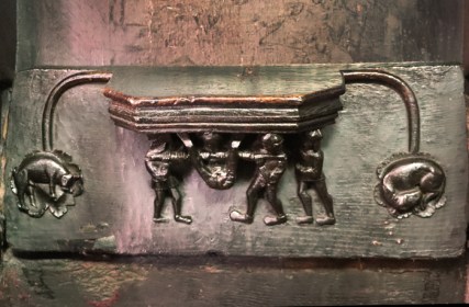
Enjoy Medieval Denbighshire (PDF) leaflet
https://www.northeastwales.wales/wp-content/uploads/2022/03/medieval-denbighshire.pdf


The splendid Grade-1 listed Llangar Church, Cynwyd, near Corwen

The small Llangar Church is exceptional.  It is Grade-1 listed and a Scheduled Monument located in the Dee valley not far from Corwen. From its lovely lime-washed white walls and its small but well-filled churchyard to its painted interior and box pews, all set in the middle of a field, there is so much that is unexpected in Llangar Church. It has been subjected to detailed historical and archaeological research, and is accordingly much better understood than many other churches in north Wales.  This work, looking at over 500 years of use, means that there is far too much information to include here.  We were shown round by visitor guide Heather on the day, who was excellent, but there is not always a tour available, so the official Cadw guide book is certainly one way go to if you want a more informative account, with 18 pages dedicated to Llangar Church.  The survey and excavation report published in Archaeologia Cambrensis in 1981 (pages 64-132)  is the most detailed report available, and can be accessed online.  See Sources at the end of this post for both.

Visiting details and a map are at the end, but do note that this can be combined with a visit to the brightly painted 17th century Rhug Chapel, which is a 5-10 minute drive away, also on the map at the end (and about which I have posted here).

The meaning of the church’s name remains uncertain.  One interpretation suggests that it it can be translated as “Church of the White Deer,” whilst another suggestion is that it might refer to the name of a neighbouring Iron Age hillfort.  The Coflein website refers to it as “All Saints.”

Whatever the meaning of its name, the first documented evidence of it dates to 1291 and the church was probably founded earlier in the 13th century, serving local farms and the services that supported them.  It escaped the destructive attentions of the Reformation, and was used until 1856, when it was replaced by a new church in Cynwyd that was both bigger and far more conveniently located.  Although abandonment of the church, combined with its relatively inconvenient location, led to neglect, decay and damage, it fortunately escaped being plundered for building materials, and avoided the indignities of Victorian restoration work that usually augmented and remodelled what was found rather than merely preserving an architectural legacy.

It was not until the 1970s that conservation work accompanied by survey and research projects began to rescue the site and uncover some of its complex architectural and social history.  The church was not a time capsule of a single particular period, but a palimpsest of multiple periods.  This was a living, breathing community resource for over the 500 years, and as people and ideas changed, so did the church.  The Cadw analysis of the architectural development of the church identifies five main phases:  Medieval, Early 17th century, Mid to Late 17th century, early 18th century and later 18th and 19th centuries.  The scatter of painted and engraved dates through the church from the 17th century suggest that that this was a period when the church underwent a number of repairs and modifications.

The churchyard

The entrance to the churchyard is marked by an attractive and remarkably solid 18th century stone lych gate, with double wooden doors.  Like all lych gates it provided a shelter for coffin bearers and a place to rest the coffin bier until the service began, and also served as a formal entrance to the churchyard.  The slate roof has two tiers of decorative pointed tiles on the churchyard side.

The churchyard is on a slope.  To provide a flat surface on which to build the church, material was removed from the east and transferred to the west end.  The dangers of this scheme, leaving one end much more consolidated and compressed than the other, resulted in later structural problems on the north side (opposite the porch side) and at the west end.  Over the the decades, many of the headstones have started tilting downhill.

The cemetery has a particular charm all of its own, which is difficult to define but has something to do with the simplicity of the grave monuments, and the general absence of ostentation. The earliest of the monuments in the churchyard date to around 1600.  Chest tombs of the 17th and earlier 18th centuries cluster close to the church itself, whilst those further away were later.  These later graves were both chest tombs and graves marked by a headstone and footstone.  The cemetery went out of use in the 1870s, when the church was abandoned.  The church and churchyard, built into the side of a hill, are rather exposed and some of the inscriptions are very worn.  Interestingly, most of those graves before 1825 were inscribed in English, whereas later ones were largely in Welsh.

18th century

1821

1841

There is also a sundial base just beyond the church porch.

Llangar Church and churchyard showing the northwest corner, by the Dee, completely free of graves. Aerial view. Source: RCAHMW Coflein

In general the north side of a churchyard was the last to receive graves, either because it had previously been in use for community activities or because, being darker and colder, it was less attractive for visiting.  In the case of Llangar the northwest corner remained entirely free of burials right up to the moment of its abandonment, but this is probably because of problems with subsidence, a theory supported by various changes made to the church’s architecture to counter structural difficulties.

The church exterior

The guide book has a step by step tour of the exterior as revealed by the survey work.  It is a fascinating detective story over two pages, perfect for anyone doing a self-guided tour on a dry day.  The short version is that the south wall (porch side) dates to the Middle Ages, and the north wall was medieval but was modified over the centuries, with some windows blocked and others added. The north wall is now propped up by a modern retaining wall added during the renovation, but it is worth looking out for a top-to-bottom jagged line like a crack at the west end, which shows where structural work was carried out in the second half of the 17th century.  The west wall was rebuilt in the early 18th century.  The porch was added in the early 17th century, re-roofed in 1702, and the big ornamental window in the Perpendicular gothic style probably dates to around the same time.   

The interior

Visitors enter the church via the porch with two stone benches, probably dating to the early 17th century.  There is paintwork and various pieces of graffiti carved into wood and stone. Take note too of the noticeboard showing some of the restoration work.

As you walk in to the church, you are confronted with a fabulous red-painted life-sized skeleton representing Death, at gallery level on the opposite wall.  As a reminder that a church is the interface between the living and the dead, and that life is only a temporary condition before interment and Judgement Day, this can scarcely be beaten.  There are more details about this image below.

The ground floor is a single space with a floor covered in stone slabs and a small overhead gallery at the west end, which was probably used for the musicians.  There are no aisles or other architectural divisions.  The space beneath the gallery was clearly reserved for parts of the congregation that had the lowest status, at the furthest distance from the sacred east end, and was very dark and cramped beneath the low ceiling.

The earliest parts of the wooden beamed ceiling are thought to date to the 15th century, although timbers were replaced and repaired in subsequent centuries, and today most of them are modern, from the 1970s restoration.  The east end, traditionally the sacred end of a church, is marked by a “canopy of honour” dating to the late 15th or early 16th century, a barrel-shaped ceiling that would have shown sacred themes in paintings that have now been lost.  It is thought that they may have looked like those at St Benedict’s Church at Gyffin near Conwy showing the twelve apostles (its website is here, complete with a virtual tour).  

The only feature that would have furnished the church of the Middle Ages to survive is the simple font set into a niche, which has been moved from its original position, probably in the 18th century.  Most of the surviving fittings date to the early part of the 18th century.

From the 18th century, the public sat in the surviving box pews along the north wall and on backless bench pews on the south wall.  Four of the elegant box are dated 1711 (belonging to the Hughes family of Gwerclas, 1759, 1768 and 1841.  One preserves the initialse of one of its occupants.


Another pew, at the south side of the 18th century altar and dated 1841, was used by the rector’s family.  Opposite, on the other side of the altar, is a painted 18th century cupboard topped with a winged angel.  It is set into the north wall dating to the 18th century, with three keyholes, requiring three keyholders.    The altar itself dates to the 18th century but was built of 17th century wood.  The window above the altar is flanked by two panels, which between them show the Ten Commandments, in Welsh.  Originally the east end would also have housed a pulpit, but this was moved to part way along the south wall.  It is  a three-tiered pulpit, which was probably moved from the east end sometime after 1732 to allow the altar rail to be employed for the giving of the sacrament.

Like nearby 17th century Rhug, Llangar’s interior wall paintings escaped the whitewashing vigour of the Reformation, but unlike Rhug, the paintings represent different time periods, from the 14th to late 18th centuries. Some images were overpainted with new ones, and many are very faint.  One of the paintings has been removed to preserve it and is now in the exhibition area at Rhug Chapel.  The Cadw guide contains a full description of all of the paintings, by A.J. Parkinson, but here are some highlights.


North wall

Most of the images were intended to provide visual material to support sermons, which Parkinson refers to as “teaching aids.”  The fabulous skeleton is brandishing time’s arrow in one bony hand and a winged hour-glass in the other.  Between his legs are a shovel and pickaxe, tools of the gravedigger. He is dated tentatively to 1748, the death of rector Edward Samuel, who was a notable Welsh scholar and poet.  Looking to his left, on the front of the gallery, are some elegant yellow frames with floral motifs, containing texts that are now too faint to read, but may by Biblical.  


To the right of the skeleton, over the window, is the name of the rector in 1730, and to the right of this was the Royal Arms of the same period, now in the Rhug Chapel visitor centre.

The rest of the north wall above the box pulpits contains overlapping images, the earliest of which, possibly 14th century, is a bishop (very difficult to make out) in the doorway of a substantial and rather exotic church, the towers of which can be easily seen.

The red frame possibly dates to the 15th century and probably contained a narrative, such as the life of Christ, or scenes from the lives of saints.  Other decorations along the wall were painted over in the 18th century.

On the south wall are a series of morality-themed panels outlined in red, probably dating to the 15th century.  All are very faint.  Some of them show representations of the Seven Deadly Sins, in which each sin is personified and is shown riding an appropriate animal.  These are very difficult to make out, but are almost unique.  Jane Durrant’s reconstruction below shows what they may have looked like in the late medieval period (scanned from the Cadw guide book).

Cutaway reconstruction showing teh south wall panels as they may have looked in the 15th century. By Jane Durrant. Source: Cadw guide book by W. Nigel Yates (full details at end, p.28).

On the left is a stag, representing lechery, and on the right is a wild boar representing gluttony, two of the Seven Deadly Sins

The gallery with benches, at the west end, is reached by a flight of stone stairs. It probably housing the musicians and singers, retains a very unusual four-sided music stand.

Abandonment of the church

Llangar church with a temporary roof. Source: RCAHMW https://coflein.gov.uk/en/site/93771/images

From the Middle Ages to the 19th Century populations changed, and parish boundaries often ceased to be representative of where people were concentrated and wanted to worship.  In the middle 19th century Llangar and Gwyddelwern were neighbouring parishes, but Llangar’s population did not exceed 251 people dotted around the parish, whereas Gwyddelwern’s population had reached 1,118, of which nearly half lived in Cynwyd, near to Llangar.  In 1853 the decision was made to redraw the parish boundaries so that Cynwyd was in the parish of Llangar, but at the same time it was also decided that a new church should be built at Cynwyd to replace the inconveniently located Llangar Church.  Llangar Church had gone out of use by the mid 1870s except for occasional burials.  Some abandoned buildings are robbed for their materials, but Llangar survived intact, although as its roof deteriorated, so the rest of it came under threat.

Restoration

Noticeboard in the church porch

The importance of Llangar was recognized in the 1960s, and it was taken into care by the Welsh Office in 1967.  Restoration work began in 1974.  There is a noticeboard in the porch of the church showing some of the restoration work, as well as on the Coflein website.  Amongst many other restoration activities, one of the big structural changes accomplished during the restoration was the addition of a retaining wall on the outside of the original wall on the eastern end of the north side.  This should continue to stabilize the church to secure its future.  The roof was largely rebuilt, and most of the interior required conservation work.  Survey work, involving a number of different specialists, began to reveal the history of the church and churchyard.

Final Comments

More than any other church that I have visited in recent years, Llangar provides a sense of a place of social congregation.  This was off the beaten track, even for rural people who came from their farms and forges to attend the Sunday service.  Many of them will have met at market, but a sense of real community probably only developed on the back of the weekly congregation, which was a social as well as a religious activity, attended by entire families.   The paintings on the walls, changing over time to suit different needs, helped to involve the congregation in the Christian narrative, surrounding them with key messages and providing them with a sense of context.  The painting here was not merely decorative, like Rhug, but invested with shared articles of faith.  It is a small place, but it has a real impact.

Visiting

Source: Google Maps (with my annotations).  Llangar Church is at the bottom of the map, Rhug at the top.

Before setting out, it is vital to check the website, because the church is open only on certain days of the month in the spring and summer, and is closed during autumn and winter.  Do note that opening times are timed to coincide with those of nearby Rhug Chapel, so you can do both at the same time. https://cadw.gov.wales/visit/places-to-visit/llangar-old-parish-church

Llangar Church and its churchyard are located in the Dee valley in a field just off the B4401, a well-used tourist route to the eastern side of Lake Tegid (sometimes referred to as Lake Bala).

Map sourced from the Coflein website with my annotations

There is a large lay-by opposite the farm track that gives access to the church.  The church is sign-posted, but when I was there the sign was hidden by tree branches.  There is a small post box on a pole next to the farm track that leads to the church, and a sign on the open gate for Station Cottage.  The track leads downhill for a minute or two, past farm buildings on the left. The road goes hard right and then hard left.  At the left turning, there is a gate on the right hand side (with a sign to its left saying Guide Dogs Only) that takes the visitor across a field, complete with mud and cow-pats, through a small gate on to a grassy footpath flanked by upright slates.  This leads to the lych gate and the churchyard beyond.

For those taking unwilling legs into account, although it is only about 5-10 minutes from car to lych gate this is very slippery underfoot after rainfall, meaning that this would almost certainly be better approached during a dry period.  Part of the graveyard is on a steep slope, which would make exploring it challenging, and there are steps up to the gallery within the church, but otherwise there should be no difficulties.

If you want to get the most out of the visit, the guide book is very helpful (see Sources below), covering both Llangar Church and Rhug Chapel as well as Gwydir Uchaf Church near Betws-y-Coed, which I have not yet visited, but looks fabulous.  The guide book is particularly strong on Llangar Church.  It can be purchased at Rhug Chapel, or ordered online from the usual sources.

If you plan to include a walk in your visit, the farm track from the road leads to a public footpath that runs along the disused railway track, which a couple who had arrived early recommended.  There are many good walks in the Corwen area, some of which are detailed in an excellent leaflet, which can be downloaded here as a PDF.

Sources:

Books and papers

Parkinson, A.J. 1993. The Wall Paintings. In Yates, N.W. Rug Chapel, Llangar Church, Gwydir Uchaf Chapel. Cadw, p.37-39.

Yates, N.W. 1993. Rug Chapel, Llangar Church, Gwydir Uchaf Chapel. Cadw

Additional reading:

Shoesmith, Ron 1981.
Llangar Church. Archaeologia Cambrensis vol.129, January 1981, p.64-69
https://journals.library.wales/view/4718179/4748029/87#?xywh=-163%2C-2%2C2584%2C3638
Llangar Church. The Graveyard Survey

Archaeologia Cambrensis vol.129, January 1981, p.70-132
https://journals.library.wales/view/4718179/4748029/93#?xywh=-169%2C-8%2C2584%2C3638

Although I haven’t yet managed to get hold of it Heather, the Cadw visitor guide, also recommended R. Suggett’s Painted Temples: Wallpaintings and Rood-screens in Welsh Churches, 1200–1800. RCAHMW 2021.

Another book that I haven’t yet seen, to which Peter Carrington alerted me, is Archaeologies and Antiquaries: Essays by Dai Morgan Evans edited by Howard Williams, Kara Critchell and Sheena Evans. Archaeopress 2022, which has four chapters dedicated to Llangar.
https://www.archaeopress.com/Archaeopress/Products/9781803271583

Websites

Coflein
All Saints Church, Llangar
https://coflein.gov.uk/en/site/93771/
All Saints Church, Llangar, Images
https://coflein.gov.uk/en/site/93771/images

National Churches Trust
St John the Evangelist, Cynwyd
https://www.nationalchurchestrust.org/church/st-john-evangelist-cynwyd

The colourful and uplifting Grade-1 listed 17th-18th century Rhug Chapel, near Corwen

Having visited Grade-1 listed Rhug (pronounced “rig”) Chapel around 20 years ago, I had always meant to return because I found it such a joyous place.  A small building, it is a jack-in-a-box full of surprises.  Although fairly plain on the exterior, it escaped Reformation erasure as well as any major Victorian remodelling.  The interior retains all of its 17th Century charm, an extravaganza of bright paintwork, wonderful patterns and motifs, and lively carvings.  It is a celebration of colour, very unusual in most of Britain’s attractive but sombre post-Reformation Anglican buildings.

The chapel is in a rural setting, just to the west of Corwen in the Dee valley, with plenty of footpaths in the immediate area.  You might consider visiting the nearby and remarkable little Llangar Church at the same time (which I have posted about on this blog here).  Both are open only a few times a month for a part of the year, closed for the rest of the year, but their opening times are co-ordinated so that they can be visited on the same days.  Visiting details for both are at the end of the post.

Many thanks to Cadw guide Heather for a great introductory talk, and for pointing out many details that we might otherwise have missed, and there was plenty of time to ask questions and wander around afterwards. There is not always a guided talk available.  I’ve written up some of the top level details of the visit below, but I recommend buying the Cadw guide book, which is stuffed full of information and great photos.  It also has the details of Llangar Church and Gwydir Uchaf Chapel.  I haven’t yet visited Gwydir Uchaf near Betws-y-Coed but it is one on my list.

Apologies for the poor quality of the interior photographs, which are very grainy and occasionally a bit blurred, due to the low lighting that helps to preserve the paintwork.  Hopefully they will still suggest that the chapel is very much worth a visit.

Background

Cross at Rhug, brought by William Salusbury from Denbigh

Rhug Chapel, properly the Chapel of Holy Trinity, was built as a private chapel by Colonel William Salusbury (1580-1660), set apart from Rhug Manor.  The land in which Rhug sits belonged to descendants of Prince of Powys Madog ap Merdudd (who died in 1160) until it passed to a daughter, who married into the Salesbury family.  Sir Robert Salusbury, the son of this marriage, added the lordship of Glyndyfrdwy to the family’s property, once in the ownership of the rebel Owain Glyndwr.  Robert died in 1599, and his only son, who had no children of his own, died only nine years later in 1608.  The estate passed to Sir Robert’s brother instead, Captain John Salusbury.  He too died without children, only three years later, in 1611 and was in turn succeeded by his brother, William Salusbury.

William Salusbury was once a privateer (a type of state-authorized pirate) in the East Indies, and most importantly a royalist governor of Denbigh Castle, who was known in old age as “Hen Hosanau Gleision,” which translates as “Old Blue Stockings.”  He is best known for his defence of Denbigh Castle for the royalist cause during the Civil War. Denbigh fell to the parliamentarians but not until  after six months under siege when he was ordered by the king to surrender.  

Denbigh Castle. Source: Cadw via Wikipedia

Inheriting the Rhug estate in 1611, William Salusbury found himself saddled with heavily encumbered estates, mortgaged to the hilt, and spent the next 30 years turning this situation around.  The chapel was built for his family’s private worship.  His religious preferences leaned towards the Anglican “high church” of Charles I, which accounts for the bright colours and the sense of celebration.  The services were carried out in Welsh, and many of the texts within the chapel are in Welsh as well as Latin.

On his death at the age of 80, having lived long enough to see the restoration of the monarchy, William left a deed of endowment dated 3rd January 1641 so that services should be maintained, and continue to be delivered in Welsh.  He also required that the curate was dedicated to the chapel and was not employed elsewhere as well.  The endowment was provided with portions of land that would provide the chapel with an income, managed by trustees.  The original requirements were ignored some time after William’s death, and the vicars of Corwen or Llangar usually took Rhug into their existing domains and delivered the service in English.  In the mid 19th Century an additional sum was bequeathed to the bishopric of St Asaph in order to reinforce the original stipend to the chaplain.

The Exterior

Approaching the church we paused at a tall cross, around 6ft (1.8m) tall, on a plinth and three steps.  This is not contemporary with the construction of the church, but predates it, having been brought by William Salusbury from Denbigh Castle.  Both the east window and the western door are accessorized with sculptural features.  At the east end these are two heads, one with a crown and one with a mitre; at the west end they are carved into a loosely floral or leafy motif. The tracery in the windows was a 19th century addition, as was the small belfry.

In the churchyard there is a circular fenced area with three large headstones, and two secondary ones.  These are headstones from the 1860s belonging to the Wynn family.  The central one features a lighthouse on top and a horseshoe at bottom left, belonging to a daughter who died after falling from her horse.  The lighthouse, of unusual four-sided construction, represents the one on Bardsey Island, once the property of the estate.

The church is surrounded by a lovely Potentilla hedged walkway.  Some of the Potentilla, yellow and white, was in flower.  I have never seen it used as hedging before, and it works beautifully.

The Interior

Open the door, and you will find yourself given the option of climbing a staircase to the gallery on the left, or opening interior doors to proceed in to the nave (main seating area) and the chancel beyond (the sacred east end) on your right.  The lighting is very low, so it is worth sitting in one of the many pews for a minute or two to let your eyes adjust, particularly if it is a bright day outside.  Upstairs, the gallery was probably used by musicians.  It provides a superb view of the ceiling and beam decoration.

The beams and trusses of the hammerbeam ceiling are painted with flowers, grapes and foliage in bright colours. One of the cross-beams shows the date of construction, 1637.  The 16 and 37 are either side of the abbreviation IHS, which stands for the first three letters of the name of  Jesus in Latin and is frequently sees on gravestones in the area.  The same IHS motif is found elsewhere in the church.  The beams themselves are painted with flowers and grapes vines that spread vigorously towards the painted sky. Ceiling bosses, wooden features that traditionally sit over the meeting of beams, are also beautifully painted with a variety of motifs.


Between the beams, the ceiling is also painted.  Over the nave the sinuous shapes emulate wispy clouds.  Over the chancel a “canopy of honour” is provided by a wonderful heavenly scene of angels and stars on a blue background.

Angels are a recurring theme in the small chapel, with four wooden sculpted angels suspended at the base of roof trusses and others decorating the fabulous wooden, candle-holding chandelier hanging from the centre of the church. 

The optimism of angels with their promise of heavenly mercy is balanced by the grim reality of impending death.  The skull and skeleton are accompanied by candles burning down, an hourglass with the sands draining, and a dial, both signifying the passing of time.  At the base of the dial the words “hora fugit” (the hour flies).  In the centre of the hourglass and dial is the phrase “ut hora sic vita” meaning “as with the hour, so with life.”  The welsh inscriptions below this are translated, courtesy of the Cadw guide book , as follows:

  • “as the flame gradually consumes the tallow of the lighted candle, so life on the orbit (earth) perishes daily” (from a 16th century carol)
  • “lifetime, however long its stay, will come to an end by night and by day” (from the Englynion y Misoedd, Stanzas of the Months)
  • “my nose and my face are perished, very dumb am I, no-one knows me” (from a poem attributed to Ieuan ap Rhydderch)
  • “every strong one is weak in the end” (a 16th century proverb)

One of the most celebrated features of the chapel is the frieze that runs at the top of both north and south walls, consisting of a series of rectangular pieces, highly coloured and very ornate, each showing a small creature at its centre, some identifiable as either from nature or myth, and one which is completely unidentifiable.

In the chancel, flanking the altar, are two unusual canopied benches looking rather like four-poster beds.  The role of these has been much-discussed and although it is not known exactly how they were used, a plausible suggestion is that at least one was a family pew.  The other might also have been a family pew but in the absence of a pulpit may have served as a place from which the service could be delivered.

The pews themselves were plain benches when the church was first built, but back rests were added a little later.  On each side, from front to back, each of the pews was connected with a single piece of wood, with scallop-shaped openings carved out to provide access to the pews.  Facing into the aisle, the sections between these access points are carved with images, quite difficult to see in the low light without a torch, depicting birds, animals and imaginary creatures.  The carvings were fairly difficult to make out in the light conditions on the day so I tortured the photos below both in the camera’s settings and in Photoshop.  Even so, they are still fuzzy.

The frieze along the top of the wall and the carvings on the side of the pews seem somewhat reminiscent of misericords.  Misericords at Chester Cathedral (from its monastery days), and both Gresford and Malpas parish churches are part of a Medieval tradition that includes the grotesque, the humorous, and the fabled in the holiest sanctuaries of their Christian homes.  Although the images at Rhug are at least two hundred years later than those at Chester Cathedral, they do echo this earlier medieval Catholic tradition of combining Christian icons and motifs with wild, mythological and completely invented imagery.  The world of the “other,” neither sublime heaven nor the realm of pedestrian human reality, is where demons, the unexplained and the unknown reside.  Positioning them alongside Christian images, like the pelican plucking her breast to feed her young (immediately above, a Christian symbol representing the sacrifice of Christ for humanity) emphasizes how humans negotiate a world of conflicting experiences and demands, opportunities and pitfalls, both natural and supernatural.  This glorious little chapel balances the beauty of nature, the strangeness of the unknown, the fear of impending death, and the promise of angelic eternity.

Additions and restoration work

Inevitably, some restoration work was required and there were a number of tweaks to William’s original vision.  In 1854-55 the bell turret was added by Sir Robert Vaughan, some floor tiles were laid in the nave and chancel, and a mock-Jacobean chancel screen incorporating a lectern were added (compensating for the lack of pulpit in the original church).  The windows were remodelled.  Originally, according to a visitor in 1849, the windows had mullions (vertical divisions), but no gothic style ornamental tracery.  All the windows now have tracery.  As in many small churches, a lean-to vestry was added to the north side.

The font, at the rear of the south side, was added in 1864. The altar itself, and the stained glass windows, belong to the later 19th century.  The window on the north side (right as you look down from the entrance) has a particularly Pre-Raphaelite look to it.

William’s architectural legacy has only been altered very slightly.  Rhug Chapel is now under the care of Cadw who have done a lot of work to make the chapel and its surrounding site a pleasure to visit.
———–

Visiting Rhug Chapel (and Llangar Church)

First, you need to check the opening times, as the Rhug Chapel and Llangar Church are only open on certain days, and are closed entirely over the winter period.

For Rhug the opening times and other details are available on the Cadw website: https://cadw.gov.wales/visit/places-to-visit/rug-chapel. The chapel lies just off an A-road and has its own car park.   There are toilets and a picnic area, as well as a gift shop and a small exhibition area that is well worth visiting, which contains information about Rhug, Llangar and Gwydir Uchaf.  For those with unwilling legs there are no problems here.  From the car park to the church is all on the flat. You may not want to go upstairs to the gallery, because the steps are quite steep, but this will not spoil your visit.  There are no steps to access the gift shop or the small exhibit. For disabled access, see the Facilities section on the Rhug web page.

Llangar Church

If you want to visit Llangar Church at the same time, around a 10 minute drive away, its Cadw web page is at: https://cadw.gov.wales/visit/places-to-visit/llangar-old-parish-church.  At the time of writing there is no information about facilities or disabled access on the above web page, but although I haven’t yet posted about Llangar Church following my visit (working on it) there is reasonable parking in a large layby opposite.  I would not recommend it for unwilling legs after rainfall, which was when I visited, because the entire approach (slippery farm track, muddy section after the farm track, and slippery gravestones laid as pathways) was causing people to slide and slip more than somewhat as they walked.  Like Rhug it is fine once inside, except for the stairs up to the gallery.  I would give it a flat negative for wheelchair access.


Caer Drewyn. Source: Peoples Collection

As you are leaving and are pulling out of the car park, pause before turning on to the road and take a moment to look up at the hill in front of you.  Towards the peak you can make out the fortifications of an Iron Age hillfort, the well-preserved Caer Drewyn.  The stone rubble perimeter that defines it is particularly clear in bright sunshine or under snow, but even in bland light you can still make it out.  The hillfort is open to the public and can be reached by a number of footpaths.  I’ve written about it on another post here.
——-

Sources

Books and papers

Yates, W.N. 1993. Rug Chapel, Llangar Church, Gwydir Uchaf Chapel.  Cadw

Although I haven’t yet managed to get hold of it Heather, the Cadw guide, also recommended R. Suggett’s Painted Temples: Wallpaintings and Rood-screens in Welsh Churches, 1200–1800. RCAHMW 2021

Websites

BasedInChurton
The splendid Grade-1 listed Llangar Church, Cynwyd, near Corwen
https://basedinchurton.co.uk/2023/09/30/the-splendid-grade-1-listed-llangar-church-cynwyd-near-corwen/

Coflein
Rug Chapel
https://coflein.gov.uk/en/site/43855/

Dictionary of Welsh Biography
SALUSBURY, SALESBURY family, of Rug and Bachymbyd
https://biography.wales/article/s-SALU-RUG-1525

The magnificent aqueduct and viaduct at Chirk, and a very, very dark tunnel

Chirk aqueduct and viaduct on an old postcard. Source: History Points

Having engaged in a two-bridge extravaganza with a visit to the Cefn viaduct and the Pontcysyllte aqueduct via the footpaths in the Tŷ Mawr Country Park recently, I decided to complete the local big-bridge experience with the beautiful Chirk viaduct and aqueduct.  The aqueduct (lower) and viaduct (higher) run parallel within a few feet of one another, high above the floodplain of the river Ceiriog.  A towpath accompanies the LLlangollen Canal across the aqueduct, doubling as a footpath, giving great views over the viaduct and the valley below.  Even better, the aqueduct and towpath vanish into a 1381ft / 420m tunnel under the hill.  The railway, running alongside over the taller and slightly longer viaduct, does not vanish underground and carries on over the top of the hill, where there is a station.  This was a short walk because I had an appointment elsewhere, although it didn’t have to be because once you are on the canal towpath you can simply keep walking in either direction until you feel that it’s time to get back to wherever you have abandoned your car.

Cleaning the Chirk aqueduct in 1954 showing the cast iron plates. Source: History Points

The aqueduct and viaduct, at different heights, seem like such a good pairing but they were not built at the same time, and nor were they designed by the same civil engineer or built by the same contractor.

The aqueduct was built to carry the Llangollen Canal, which was part of a complex plan, only partially realized, to connect north Wales to the large national canal network, about which I have already talked in detail on my post about the building of Pontcysyllte.

As typical with the Jessop and Telford partnership, the  aqueduct had an innovative design.   (https://www.pontcysyllte-aqueduct.co.uk)

As part of this immense canal project the  Chirk aqueduct was built in 1801, four years earlier than the better known Pontcysyllte aqueduct. The aqueduct was a collaboration between William Jessop and the younger Thomas Telford, who had been hired to assist Jessop, but had proved himself an innovator in his own right, even though he had lacked canal experience when taken on.  It is unsurprising, therefore, that the the aqueduct was an innovative design. The weight of the water and its traffic were carried on 10 masonry arches with hollow sections, and a water channel provided with a flat bed of iron plates, its brick sides sealed with hydraulic mortar.  The successful deployment of iron plates inspired the construction of the even more innovative Pontcysyllte aqueduct.  The canal travels under the hill via a tunnel to maintain its level, from where it parts company with the railway, which travels at a higher level than the aqueduct.

The railways came later than the canals, eventually replacing them as the primary form of transport, and the Chirk viaduct came 47 years after the aqueduct as part of this vast expansion and eventual domination of rail.  The viaduct, designed by Henry Robertson who also designed the nearby Cefn viaduct, was built by Thomas Brassey for the Shrewsbury to Chester Railway in1848 (to whom a chapel is dedicated in Chester Cathedral).  It was 710ft (220m) long and 70ft (20m) above the valley floor, with a total of 16 arches.  Look out for the nice decorative niches at either end, the sort of flourish that demonstrated the pride with which such massive civil engineering enterprises were regarded.  It must have felt as though they were changing the world, which they were.

The view from the aqueduct is mainly of the river Ceiriog floodplain, a vast grassy area.  The Ceiriog runs to one side, like something of an afterthought.  The vast expanse of green, although lacking any ooh-ah factor gives a real sense of how much land is being traversed by the arches, and how far above the ground level it is.  And it’s a long way down!  The peace seems so complete that a train suddenly rumbling so closely to the towpath is just a little disconcerting.


If you are planning to walk through the tunnel  you absolutely must take a torch, but do note that you do not have to go through the tunnel to continue along the tow-path.

If you want to avoid the tunnel but proceed to the other side of towpath, stop at the information sign near the tunnel entrance.  There’s a ramp up to the road, and you can walk the length of the tunnel over-ground (a couple of minutes along a quiet road) and rejoin the towpath on the other side.  More about this over-ground route, and other visiting details, are below.


There’s a great view of the aqueduct from a viewing platform at the end of Station Road, if you walk back that way, and you can also reach it from the aqueduct side by going up the slope.

Visiting Details

There are various options for parking, depending on how close to the bridges you want to be, and which side of the tunnel. You could park in Chirk itself or at the Chirk marina, for example, and head south towards the tunnel (the bridges are on the other side of the tunnel, north to south).  Or you could park west of the bridges and head north, which means that you reach the bridges before the tunnel.  I followed the latter strategy and parked in the small car park (10 cars max, no charge) actually on the towpath opposite Canal View, just before a very pretty canal bridge.  Canal Way itself is on the towpath, but has homes along it and is strictly private parking.  The photo of the information board above is fairly dismal due to the light and shade, but if you click it to enlarge it you should be able to make out the main parking areas, plus other features.

If you park where I parked opposite Canal View, walk from the car park along the towpath, with your back to the road.  If you park up and then cross the road on to the towpath opposite, you are going in the wrong direction.  It’s a nice, stretch of metalled canal towpath through woods on either side, passing a couple of houses on the right.  You will suddenly find yourself on the aqueduct over the Dee floodplain, with the viaduct running parallel a very short distance to your left.  The tunnel is at the end of the aqueduct.

The towpath over the aqueduct has a nice safe railing with tightly woven wirework, preventing any chance of falling into the valley.  Like Pontcysyllte, however, the canal trough has nothing on the other side.  Those travelling by narrow-boat, kayak or canoe have a far more interesting time of it.

Signage on the towpath

I have mentioned that you do not have to walk through the tunnel to walk the full length of the canal towpath.  When you reach the tunnel entrance (at both ends) there is a pathway up to a road that runs parallel, and another that runs back down to the towpath, so if you don’t fancy the pitch dark (no lighting unless you bring a torch), there is a perfectly viable alternative.  I came from the Chirk Bank direction on the sign right, and vanished into the tunnel just after the You Are Here label and emerged with he blue arrow.  I took the slope up from the towpath to the road, turned left across the railway and then right down Station Road, as far as the roundabout.  Crossing the road at the roundabout, there is an excellent viewing point for the aqueduct (and a seat to sit on). Just to the left of the viewing point is the slope down to the aqueduct.

When you enter the tunnel, switch on your torch, and be prepared for drips from above even during fine weather.  The towpath in the tunnel will let two people pass, and there is a handrail along the water’s edge.  If you have small children you will probably want to go up to the road level instead, and rejoin the towpath on the other side of the tunnel because although there is a handrail to prevent adults falling into the canal, it is not a fence or barrier, just a handrail on posts.  Dogs should be on a lead.

This is suitable for unwilling legs if you stick to the towpath because it is level all the way.  If you want to avoid the tunnel and are up for some gentle slopes, the two ramps up from the towpath to the road should be okay and the roads themselves are on the flat.

Sunshine, archaeology and great views at Caer Drewyn Iron Age hillfort at Corwen

Caer Drewyn aerial photograph. The entrance at the top is at the northeast. Source: Cadw

Caer Drewyn is an Iron Age hillfort located a mile north of Corwen, with remarkable stone-built defences all around its perimeter, and terrific views in all directions.  Happily, it is accessible to the public, with a relatively easy footpath that works its way gently around the hill to the northeast entrance.

This post begins with a brief description of Caer Drewyn the Iron Age archaeological site (it is worth reading either this or another description before you visit, as there is no information signage at the site), and finishes with the the walk and views, from the car park via the farm track to the top, and back partly via the track, but also using a different, steep footpath that shortens the route.

If you use the What3Words app, you can find the hillfort at ///kitchen.quaking.segments.  Leaflets promoting local walks indicated that it was acceptable to park at the Corwen Leisure Centre, just to the north of Corwen (via Green Lane from the A5, postcode LL21 9RW).

Caer Drewyn

Willoughby Gardner’s 1922 sketch of the position of Caer Derwyn on the slope rather than around the peak of the spur.

Caer Drewyn is located on a spur projecting south and west into the Vale of Ederinion in the upper valley of the river Dee, some 800-985ft above sea level and, at its south, 500ft (152m) above the Dee floodplain.  The aerial photo shown at the top of the post gives some idea of the way in which the site dips fairly steeply from east to west over two loosely defined natural terraces. 

Caer Drewyn is defended by vast stone defences, spreading to beyond 15ft wide in places.  They do not merely defend a particular weak point; they enclose the entire perimeter – and there is an awful lot of perimeter to defend (3 hectares / nearly 7.5 acres, measuring c.629ft / c.192m north-south by 705ft / 215m east-west).  This sort of stone defence is not unique.  There are a number of examples in Ceredigion and in south Merioneth (e.g. Craig yr Aderyn, and Castell y Gaer) both on or near the mid-west Wales coast, with which the area may have had contact via the route that follows a geological fault-line. Other similar examples are further afield in northwest Wales including the famous Tre’r Ceiri on the coast of the north Llyn Peninsula, which has a complete stone perimeter and includes very clearly visible hut circles within.

Although parts of the stone walls were cleared of bracken and other vegetation in the late 19th and early 20th centuries, ahd graving sheep help to keep it down, Caer Derwyn hillfort has not been excavated, so all knowledge is based on observation of the extant features.  According to the Coflein website, the hillfort was probably developed over at least three phases.  

The earliest phase is thought to have consisted of a smaller curvilinear earthwork at the northeast of the hillfort that stands today, and survives in part as an earthwork outside and to the east of Caer Drewyn.  This can be seen on the aerial photograph at the very top of this post.

The next phase is the vast rubble-walled site that dominates the hill today.  This later hillfort was defined by the stone rampart, which Willoughby Gardner describes  in his 1922 paper as  consisting “of a core of rubble stones, faced on either side with a wall of dry masonry.”  These surviving patches of stone facing may suggest that the rampart may have been equipped with an inner wall-walk.

Instead of sitting around the peak of the spur, the hillfort actually sits on the slope, meaning that the interior can be seen from below.  Like many hillforts, it is ideally located for visibility over the landscape, in this case with views over the surrounding area, including the valleys of the rivers Dee and Alwen, which meet just to the east, the Berwyns to the south and the north and east across to the rest of the Clwydian range.  These views are wonderful on a clear, bright day.  Toby Driver points out that in spite of the defences, the above-mentioned fact that the interior of the hillfort can be viewed from below somewhat undermines its strategic value.

Willoughby Gardner’s 1922 plan of the northeast entrance of the hillfort

The hillfort could be approached from the west and the northeast, where the two entrances were in-turned, a typical feature of many hillforts that helps to control access to the interior.  Willoughby Gardner says that there was a spring a short way down from the west entrance.  The entrance in the northeast corner where the cairn is located, which is the highest point of the site and shown clearly bottom right of the aerial photo below, may have featured a guard chamber, another characteristic feature, suggested by the complex jumble of stone that implies at least one additional feature at the entrance.  Willoughby Gardner estimates a 12ft diameter. So-called guard chambers are recesses in the entrance passages hillforts, mainly in north Wales and the Welsh Marches, but the name does not mean that the function of these recesses is actually understood, and they may have been used for some sort of religious or alternative function.

You can see circular dips dotted here and there in the walls.  These may or may not be relatively modern features.  They were there in 1887 when the Reverend Hugh Pritchard was investigating.  One interpretation is that they could have been grouse butts (small enclosures used as grouse-shooting positions), but this is unsubstantiated.  You can see some of them most clearly in the aerial image below.

Caer Drewyn showing northeast entrance, annex, and circular depressions in walls. Source: Peoples Collection Wales

The interior surface has been examined by Willoughby Gardner in 1922 and by the Engineering Archaeological Services (EAS) in 2006.  Willoughby Gardner comments that there are circular structures within the hillfort.  He casts doubt on them being original because in his experience wattle-and-daub or wood was the favoured material for hut circle construction.  The EAS, acting on behalf of the Heather and Hillforts Landscape Partnership Scheme (Denbighshire County Council) carried out a topographical survey which identified eight possible hut platforms within the walls.  Apparently aerial photographs taken in low winter light confirm hut-like shapes in the central and eastern parts of the enclosure.  I had a poke around for anything resembling them on the ground, but could find nothing amongst the bracken.  Winter, when the vegetation has died down a bit, would be a better time for that sort of optimistic activity.  

To the south and southwest there are views over Corwen, the Berwyns and into the far distance.  There is excellent line of sight from Caer Drewyn to other hilltops, some of which housed other hillforts that may or may not have been contemporary.  I walked all the publicly accessible hillforts in the southern Merioneth area in mid west Wales a couple of years ago my write-ups here), and each of them had a clear line of sight to one or more neighbouring hillforts, which would make sense both for mutual support and maintaining lines of communication amongst friendly neighbours, and for keeping an eye on any hostile neighbours.

Caer Drewyn. Photograph by Llywelyn2000, CC BY-SA 4.0. Source: Mapcarta

A third phase apparently added a small  trapezoidal annex to the north-east of the fort, which employs the earliest earthwork of the hillfort.  In the aerial photograph above and to the right you can see one very clearly on the left, but there are others visible on some photographs, much fainter, which may also be hut circles.  There is nothing to indicate a date, but Coflein suggests that it may have been added after the hillfort had gone out of use in the Romano-British period, presumably because of the  possible hut circles, but it could equally have been much later.

Without excavation it is impossible to know how the interior of either earlier or later hillfort forms, or the annex were used, or to know for sure the period over which they were used. 

The term “hillfort,” combined with defensive structures such as banks, ditches, stone walls, defended entrances give the impression that these were built primarily for exclusively military purposes, but it is by no means certain that this was there only purpose or even, in some cases, their primary purpose.  Secondary uses could include storage of agricultural output, protection for livestock, and a visible territorial marker in the landscape. There is no room here to enter into a discussion on the subject, but if you are interested have a look at Toby Driver’s 2018 online paper on the subject (free to access): New Perspectives on the Architecture and Function of Welsh Hillforts and Defended Settlements.  Whatever their primary and secondary purposes, the sheer amount of work that goes into an enterprise like this, or a banked-and-ditch hillfort is considerable, and there was certainly a very desirable outcome in mind when a hillfort was embarked upon.

The site continues to be used for grazing sheep, and it is recorded that it was used as a hafod (seasonal grazing) in around 1600.  It is reputed to have been used as temporary bases for Owain Gwynedd in the 12th century during his conflict with Henry II, and by Owain Glyndwr during his rebellion in 1400.  There is apparently no actual data to support either theory.
———-

Visiting details: parking, the walk and the views

I was advised that it was acceptable to park at the Corwen Leisure Centre, just to the north of Corwen (via Green Lane from the A5, postcode LL21 9RW).  When I arrived, there were only three other cars there, and no signage to indicate that parking was restricted.  By the time I returned to the car a couple of hours later mine was the only car in the car park, so I didn’t feel that I was intruding.

Walking up to the road from the car park, turn left (east).  There is no pavement, just a narrow grass verge, but you are going a very short distance, just a few metres, before a wide farm track is clearly signposted to Caer Drewyn on your left.

Follow the attractive track for a few minutes, past a couple of farm buildings on your right.  You will reach a gate.


On the other side of the gate is another signpost that gives a few options.

—–

The red box shows part of the farm track taking the easy route up the side of the hill towards the highest part of the hillfort and the northeast entrance (pink arrow). The blue arrow shows the steep footpath that cuts off a corner of the easier route. The yellow arrow shows the lowest point of the hillfort, which is also an access/exit point. Click image to enlarge. Copyright CPAT. Source of image: Britnell and Sylvester 2018

For Caer Drewyn you can either turn left and follow the farm track, or go straight ahead on a very small footpath straight uphill, which intersects with the farm track at a much higher level. Looking at the aerial photo to the left, it should be possible, although I didn’t realize at the time, to cross over the farm track (or, if you are on the farm track turn left at the point where it intersects with the footpath) to go up to the very lowest point of the hillfort defences and the western entrance.  I wouldn’t, myself, because I really enjoyed the views from the farm track.  It would make a shorter and easier walk for anyone who follows the track to the northeast entrance but doesn’t want to do a full circuit of the hillfort, to follow one set of walls down to the bottom of the hillfort and exit back to the farm track or footpath via the lower entrance.

The farm track is the easy option, so I decided to follow this and, on my return journey, take the footpath down.  I would strongly advise that you take the farm track either on your ascent or descent, because the views are so terrific, and you will miss some of them if you confine yourself to the footpath.

The farm track heads west for a short distance on the level, and then you will reach another signpost that points you right, uphill through a gate that has a walk-around on its right.  Take the uphill option that takes you relatively gently across the side of the hill towards the northeast entrance.  This is uphill all the way and although not particularly steep on the seethingly hot day on which I walked it, it was noticeable.


As you climb towards the top of the hill, you will suddenly see some stone rubble on the left, like a massive fallen drystone wall.  This is the hillfort perimeter.  Continue to follow the farm track, running parallel to the walls.  You will eventually reach a gate, which is the end of the line.  Ahead of you is a superb view to the east, and on your left, just a few metres behind you, is a mass of stonework including a roughly conical pile of stone which is a useful point to orient yourself.  This is the northeast corner and marks the following in-turned entrance and possible guard house.  From the cairn you can see for miles and miles around.  The landscape is truly stunning.  You can also see the stone defences heading out in both directions, plunging away to your right down the slope and following the ridge left before then, too, plunging downhill.

It is easy to walk the entire perimeter because all you have to do is follow the stone boundaries, but do take into account when you are heading downhill towards the far eastern extent, that you will have to walk all the way back up again if you want to do the full perimeter back to the cairn!  Alternatively, head out of the well-worn exit at the bottom end of the hillfort to rejoin the farm track.

View over the enclosure towards the west

Looking back up the hill along the northern rampart

The interior showing the topographical tilt to the west

Although there are tracks inside the hillfort, many of them created by sheep, there are no formal pathways and if you leave the trackways, it is very uneven underfoot, with the danger of turning an ankle.  I was wearing tried and tested breathable but very solid hiking trainers that are fabulous on hot days, but it would have been better to have worn summer-weight hiking boots with good ankle support.

Well worn access to and exit from the hillfort at the bottom

Puff ball

There is not a lot in the way of wildlife, but there is plenty of bright yellow gorse in flower at the moment.  I found a perfect white puff-ball (mushroom) which I later cooked in garlic butter, and some other unidentifiable mushrooms.  There were some very occasional and very pretty wild flowers, including some wonderful harebells dotted around, but there was little else to see at this time of year.  Bird song was all around, but the singers were well hidden.  Judging from the endless rabbit droppings, this is bunny nirvana.  If you are interested in lichen, there seemed to my inexperienced eye to be many different types on the stone defences and the interior rocks and boulders and later that day I read on the Clwydian Range and Dee Valley AONB website that over 60 species of lichen were identified in a 1993-1994 study.


On the way down I kept a close eye out for a signpost for the footpath down, which chops off the corner that the farm track takes (the blue arrow on the above annotated photo).  There is no full-sized signpost, just a little way-marker on the left/south that you need to look out for.  There is a big boulder opposite, which is a useful landmark.  The first part of the footpath, from the top, consists of some quite deep steps reinforced with wood.  It then becomes a fairly steep narrow track – much steeper than it looks in my photographs below.  I suspect that the whole thing becomes a muddy stream during wetter weather, as there are plenty of signs that water courses have made their way down.  The footpath drops you at the gate back down to the road and the car park.

It only took me about half an hour to get up to the hillfort, with lots of stops to enjoy the spectacular scenery, take photos and top up with water.  Once up there, you can spend as long as you like, of course, and it is a great place for a picnic.  I had it to myself, even on a sunny Saturday.

Hopefully the photos will speak for themselves, but I recommend this as a far from strenuous walk, mixing fascinating late prehistoric heritage with terrific views.  If you time your visit to coincide with stunning Rhug Chapel’s opening times (the chapel’s website is here), that would make a great second visit, just a ten minute drive away.

UPDATE:

After I posted about this walk, I found an official leaflet that includes a longer walk incorporating the hillfort, which looks really great.  The relevant page is shown below, but you can download the entire leaflet, with some other really excellent-looking walks too at https://www.denbighshirecountryside.org.uk/files/158946141-Discovering%20Corwen%20A5%20ENG%20WEB.pdf


——–


For other Iron Age sites on this blog see:

Beneath Chester’s Roman Amphitheatre – the Iron Age buildings and fields
https://basedinchurton.co.uk/2026/06/02/beneath-chesters-roman-amphitheatre-the-iron-age-buildings-and-fields/
Burton Point: The small and rather puzzling Iron Age promontory fort on the Wirral
https://basedinchurton.co.uk/2026/04/11/the-small-and-rather-puzzling-burton-point-promontory-hillfort-on-the-wirral/
Exploring Maiden Castle Iron Age Hillfort, Bickerton Hill (mid-Cheshire Sandstone Ridge)
https://basedinchurton.co.uk/2025/12/01/exploring-maiden-castle-iron-age-hillfort-bickerton-hill-mid-cheshire-sandstone-ridge/

Sources

Books and papers

Bowden, M. 2006.  ‘Guard Chambers’: An Unquestioned Assumption in British Iron Age Studies. Proceedings of the Prehistoric Society, 72, p.423-436 [NOT free to view]
https://www.cambridge.org/core/journals/proceedings-of-the-prehistoric-society/article/abs/guard-chambers-an-unquestioned-assumption-in-british-iron-age-studies/E6D627EE54566C400B07C0F42CB5F18C

Britnell W.J. and Silvester, R.J. 2018. Hillforts and Defended Enclosures of the Welsh Borderland. Intarch Issue 48 (2018). Iron Age Settlement in Wales. https://intarch.ac.uk/journal/issue48/7/index.html

Driver, Toby 2018. New Perspectives on the Architecture and Function of Welsh Hillforts and Defended Settlements. Intarch Issue 48 (2018). Iron Age Settlement in Wales. https://intarch.ac.uk/journal/issue48/9/toc.html

Gardner, Willoughby. (1922). The Ancient Hill Fort known as Caer Drewyn, Merionethshire. Archaeologia Cambrensis – The Journal of the Cambrian Archaeological Association. Vol. 77. Seventh Series. 2. Vol 77, p.108-125

Savory, H.N. 1958.  Caer Drewyn. Archaeologia Cambrensis – The Journal of the Cambrian Archaeological Association. Vol 107, p.135-6

Websites

Clwydian Range and Dee Valley Area of Outstanding Natural Beauty
Hillfort: Caer Drewyn
https://www.clwydianrangeanddeevalleyaonb.org.uk/projects/hillfort-caer-drewyn/

Coflein
Caer Drewyn; Caer Drewen – Details
https://coflein.gov.uk/en/site/95431
Caer Drewyn; Caer Drewen – Images
https://coflein.gov.uk/en/site/95431/images
Tre’r Ceiri
https://coflein.gov.uk/en/site/95292

People’s Collection Wales
Caer Drewyn
https://www.peoplescollection.wales/items/5482

Aberdovey Londoner
Iron Age hillforts in South Merioneth
https://aberdoveylondoner.com/category/iron-age-hillforts-in-south-merioneth/

—–

The puff ball as a delicious minimalist starter. Divine.