Button with an emblem of a crown at the top, little stars flanking it and elsewhere around the circuit, and text at the base
Not only have I never done any metal detecting myself, but I have never seen it being carried out either. I was lucky enough to have my first exposure to this activity with Rob Jones, famous in these parts for finding the superb Roman lead ingot near Rossett, now in the Wrexham Museum, which lead to the discovery of the Rossett Villa (being excavated late this year by DigVentures after initial work was completed at the site in 2021). With Helen Anderson, who organized the day with Rob and very kindly invited me along, we met at the field near Churton which is owned by Helen’s family, so we had no problem with obtaining permission. Rob did all the hard work, whilst Helen and I basked in the sunshine, diligently dry-brushing the thick red earth off anything that Rob found, irrespective of how old or recent it might be.
The other side of the button above
Rob Jones in situ at the field, very kindly agreeing to pose!
Rob has been a metal detectorist since 1996, and in 2020 was awarded the The Searcher Magazine‘s ‘Most Significant Find Wales’ award for his discovery of the Rossett Roman ingot. He works closely with the Portable Antiquities Scheme, reporting all his finds so that they can be included in the PAS database, and (with luck) helping to identify previously unidentified sites. He has worked as an on-site expert with archaeological projects at, for example, the Rossett villa and Basingwerk Abbey in Holywell, supplementing archaeological survey and excavation activities and helping to identify potentially rewarding places to investigate.
The field near Churton was naturally less promising than either, not having been home to either Roman or Medieval buildings, but it had the merit of being virgin territory, never having been built on or investigated before. Although under ridge and furrow in the Middle Ages, it has been largely unused for the last few decades. We had no real idea what the field might reveal, but it turned out to be a right old mix, even though the field was, in Rob’s terms fairly “quiet.”
17th century musket and pistol balls
We were all delighted by two lead musket balls and a smaller pistol ball (above), probably dating to the 17th century, all of them found in one small patch of the field in quick succession. Even though they are small, the little spheres are noticeably heavy in the palm of the hand. Both the local churches in Farndon and Holt, on opposite sides of the river, both named for St Chad, have musket ball shots in the masonry due to the offensives of the opposing forces that used the churches as their bases. I have posted about both – the post on the Grade-II* St Chad’s in Farndon (5 minutes down the road from Churton) here, and the one on the Grade-1 listed St Chad’s in Holt here.
A very intriguing object was what appeared to be a very small pouch, with holes at the top, perhaps for attaching to clothing. It would be good to know more about what this was used for.
One of the most entertaining of the finds was a piece of a toy gun, nicely made and originally painted blue, with the words RUSTLER GEM clearly visible.
A small button with four holes, the shape of a flying saucer, was surrounded by lettering, the bottom half of which clearly states “Chester,” with the rest too worn to be read, apart from a possible M. at the start (an initial?) and a clear DY at the end, perhaps preceded by an E. A brief lurch around the Internet suggests that these are typical on suits and waistcoats of the late nineteenth and early 20th centuries, and are marked with the name of the tailor.
Another button with a metal loop has a crown engraved on the loop side, together with other emblems and some indecipherable text, and is perfectly plain on the other.
A broken pair of cufflinks, with only one face remaining, was rather charming, and a piece of thimble was the sort of thing that only an experienced detectorist would have recognized.
The oldest coin we found was a penny dating to 1861, and there was also a 2003 five pence piece!
The Rustler after cleaning
The other side of the Rustler Gem
The pouch with two holes at the top, function unknown.
Top left is the half cufflink. Bottom right is the piece of thimble.
Other bits and pieces were a mixture of broken bits of modern equipment and pieces that were largely unidentifiable but, as they were found, each piece was welcomed back into the world with equal enthusiasm, brushed free of damp earth, photographed and bagged up for further examination. There was almost nothing else other than metal, although we did poke around in the holes made, and kicked out all the available mole hills to see if there was anything non-metallic. It was remnant, random stuff of everyday life, but no less rewarding for that.
The other side of the cufflink, showing the lightly ornamented face
The four-holed button showing “Chester” at the bottom and indecipherable text at the top, possibly a tailor’s name, apparently beginning with an M. and ending with DY (perhaps preceded by an E).
Many sincere thanks to Rob for taking the time to spend the day with us, and also for showing us how a metal detector functions, with different fittings available to improve sensitivity, and how a separate pointer probe helps to focus in on the object that the detector has identified after the hole has been dug. Rob even has a special customized spade for making small holes, not unlike a long-handled bulb planter but far more robust. The metal detector is a far more subtle piece of equipment than I had anticipated, and it was an education to see it in action. And many thanks to Helen for inviting me! Truly fascinating, and such a fun and mellow day.
Probably a curtain rail holder – inevitably there is a lot of junk as well as more interesting historical objects
Artist’s imaginative interpretation of how Maiden Castle may have looked, based on information from both the site itself as well as from other excavated hillforts. As no excavations have taken place in the interior beyond the entrance area, the roundhouses and accompanying square structures are largely speculative. Produced by the Habitats and Hillforts Project 2008-2012. Source: Sandstone Ridge Trust
Further to last week’s walk on Bickerton Hill, Maiden Castle sits on the route of the Sandstone Trail, on the northeast edge of Bickerton Hill (once known as Birds Hill), which is one of the Triassic red sandstone outcrops that make up the mid-Cheshire Sandstone Ridge. It is the southernmost of six hillforts along the ridge (see topographical map below). A visit to the hillfort makes for a great walk with lovely views over the Cheshire Plain.
Traditionally hillforts were associated with the Iron Age, and in general the early and mid Iron Age periods, but modern excavations have revealed that many had their origins in the Late Bronze Age, that not all of them were contemporary, and some were re-used in the post-Roman period. Some have a long sequence of occupation and abandonment, and many may have performed different functions, both in terms of geographical distinctions and even within localized areas.
Chronology of Sandstone Ridge hillforts. Source: Garner 2012, p.9
All hillforts make use of the natural topography in order to provide their enclosures with good defensive potential, including good views over the landscape. Many strategic locations are also shared, either actually or conceptually, by medieval castles.
Some hillforts surround the very top of a hilltop, such as Beeston Castle on the Sandstone Ridge to the north (a location used by Ranulph III, 6th Earl of Chester, for his medieval castle), but others like Maiden Castle are located to take advantage of a natural drop on one or more sides to provide some of the defences. These are usually referred to as promontory hillforts, and Maiden Castle is a good example. The built defences form a dog-leg curve that meets on either side of a slight projection over the steep drop of the Sandstone Ridge where it plunges down to the Cheshire Plain. As well as reducing the amount of work required to provide defences for the site, promontory forts could be just as visible as those that circled hilltops. In the case of Maiden Castle, the height of the site (c. 698ft/212m AOD) and the views from its banks at the east of the hillfort also provide good views to the east. Although it is at the highest point of Bickerton Hill, Maiden Castle only occupies a part of the high ground, presumably its size, smaller than most of its neighbours, sufficient for its needs.
Google Map of Bickerton Hill and Maiden Castle. The purple marker shows the centre of the hillfort. The ditches between banks are visible as the darker arcing lines
Maiden Castle, in common with other hillforts, had no obvious source of water, and could not therefore withstand a prolonged siege, assuming that it had a defensive role. In addition, any livestock herded on the outcrop would need to be returned to a water source. Springs were available along other parts of the sandstone trail, many of which are now dry, and some wells mark access to water today, including Droppingstone Well at Raw Head, under 3km away, and the medieval well at Beeston Castle (now dry), but there were no rivers or streams nearby. The nearest is Bickley Brook, around 2km to the east. However, it is likely that there was a lot of standing water and ponds as well as a diversity of small and possibly seasonal wetland habitats that supported different types of wildlife, with a strong avian component. It is interesting that of all the hillforts on the Sandstone Ridge, only Maiden Castle did not neighbour a river or well-sized mere, nor a well-fed stream or small mere.
Topographical map of the Cheshire Sandstone Ridge, showing Maiden Castle at the south end. Source: Garner et al 2012
The question of a water supply draws attention to the fact that the exact role of hillforts in this part of the country is not fully understood. The often massive ditches and banks, the latter supporting additional structures such as palisades, were quite clearly intended to keep one set of people (and their possessions) in, and presumably another set of people out. Specialized entrance designs reinforce this idea of controlled and limited access. At some hillforts slingshot stones, usually interpreted as evidence of warfare, have been found including at the Sandstone Ridge hillforts Woodhouse and Eddibsury, made of rounded sandstone pebbles. However, whether warfare is the correct model for the role of Cheshire hillforts is by no means clear. Localized disputes such as cattle and grain raiding might be a more plausible scenario than all-out warfare, with the hillforts perhaps (speculatively) providing places of retreat from farmsteads dotted around the surrounding plains at times of threat. The scale of investment in these structures certainly suggests that whatever their role, they were seen as necessary for local security, and probably for conveying territorial ownership and status as well. An experiment to test inter-visibility between hillforts in northeast Wales and Cheshire, called the Hillfort Glow was undertaken in 2011 by the former Habitats and Hillforts. Sadly, the Habitats and Hillforts website is no longer available, but the experiment was reported on the BBC News website. Ten Iron Age hillfort sites were included (on the Clwydian Range, Halkyn Mountain, the mid-Cheshire Sandstone Ridge, and at Burton Point on the Wirral). It suggests that if allied groups wanted to communicate a threat to neighbours, they could do so quite easily, with Burton Point on the Wirral, for example, visible as far always as Maiden Castle 25km (15.5 miles) away, as well as nearer sites on the Clwydian Range.
Maiden Castle defences as they look today, at the far south of the hillfort, seen from near the edge of the ridge, with the dark shadow marking the ditch, facing roughly to the east.
If you visit Maiden Castle in person (see Visiting details at the end for how best to locate it), you will find that the enclosure ditch between the two lines of rampart is clearly visible, although considerably less impressive than it would have been in the Iron Age, and you can walk along it very easily. The photograph here shows it in late autumn afternoon light, with the ditch clearly marked by the line of shadow.
Excavations and surveys
Varley 1940, Maiden Castle schematic plans, showing Varley’s illustrations of the defences, the entrance and the construction of the banks, showing the stone facings, figs.11 and 12, p.70-71
The Maiden Castle hillfort was first excavated by William Varley, (a geography lecturer at the University of Liverpool) and J.P. Droop (who was also involved in the Chester Amphitheatre excavations) over two seasons between 1934 and 1935, published promptly by Varley over two years in 1935 and 1936, after which Varley moved on to Eddisbury Hillfort near Frodsham. In 1940, as the first of a new series of history books, The Handbooks to the History of Cheshire, he co-authored Prehistoric Cheshire with John Jackson, with illustrations, photographs, fold-out maps and a bibliography organized by archaeological period.
Varley’s published excavations at Maiden Castle were carried out to a very high standard. As with the later book, he included plans and photographs of the entire site with particular emphasis on his excavations, which were focused on the northern end and included the entrance, and both outer and inner ramparts.
Maiden Castle, showing how the inner bank was turned inwards to form a corridor entrance. Source: Varley 1936
The excavations were very informative, confirming that there were two ramparts separated by a ditch and suggesting an additional ditch surrounding the entire defences. A possible palisade trench under the outer of the two Iron Age ramparts is the only indication that he found of a possible pre-Iron Age line of defences. The inner rampart was built using timber and sand, and was faced with stone on both sides. The outer rampart was formed of sand and rubble, with the outer side also faced with stone. The inner rampart enclosed an area of around 0.7ha, with an entrance at the northeast formed by turning both sides of part of the inner rampart inwards, to form a corridor c.17m long and 0.8m wide. A pair of postholes set within the entrance area may have been gate posts. The entrance in the outer rampart was a simple gap, lined up with the inner rampart entrance. Varley believed that so-called guard chambers (by then identified at some other hillforts) once flanked the entrance, marked by archaeological surfaces, one of which produced a piece of Iron Age pottery. However, no structural remains survived to substantiate this interpretation. The ditch between the two ramparts is clearly visible today, particularly at the south end, but Varley also identified another ditch on the far side of the outer rampart, which appears to have been confirmed by the LiDAR survey carried out in 2010. Varley’s plans and photographs have contributed to more recent research and remain a useful resource.
William Varley’s photograph of the entrance of Maiden Castle. Source: Varley 1940, Plate VIII
xxx
Although no further excavations were carried out until 1980, a number of topographical surveys were undertaken in an attempt to clarify matters. The 1980 excavation, published by Joan Taylor (University of Liverpool) in 1981, was undertaken in response to damage unintentionally inflicted on part of the ramparts by walkers, which revealed some of the internal burnt wooden construction material. This was an opportunity to re-examine the construction methods and to send some of the charred wood for radiocarbon dating, which produced dates in two clusters, which were later calibrated (a form of correction) by Keith Matthews, then with the Chester Archaeology Service. The results indicated that Varley’s instincts that the inner rampart predated the outer one were correct, producing a set around 860-330 cal.BC for the inner rampart and a set of 380-310 cal.BC on the outer rampart.
LiDAR clearly shows not only the banks and ditches but also the damage inflicted by stone quarrying both within and beyond the hillfort enclosure. Source: Garner 2012, p.50
No further excavations have taken place at the site, but a the Habitats and Hillforts project undertook a number of non-invasive surveys of the site, reported in Garner’s 2016 publication. The results of a LiDAR survey were reported, revealing that considerable damaged from later stone quarrying to the ramparts and the interior, as well as across the rest of the hill. It additionally confirmed that there were trenches from when the army had a training base and firing range at the site in the later 20th century. Finally, geophysical surveys were carried out by Dr Ian Brooks in 2011, again reported in Garner 2016, which included both resistivity and magnetometry surveys, the latter producing signs of three possible roundhouses, one of which made up a full circle, their diameters measuring 6.9m, 7.8m and 9.2m. This is a good indication of the potential of the site for producing further information, even with the probable damage to parts of the archaeological layers from quarrying (marked on the LiDAR image below as irregularly shaped depressions), but not much else can be concluded without excavation.
Possible roundhouses revealed by geophysical survey, shown in red, with irregularly shaped pits produced by later quarrying for stone. Source: Garner 2017, p.58
Summary of the amalgamated data
The structural character of the site
Artist’s impression of how ta simple inturned entrance may have looked, with a palisade on what remains of the ramparts and a walkway over the gateway, with roundhouses just visible in the interior. Source: Sandstone Ridge – Maiden Castle heritage leaflet
The site is defined by an interior sub-rectangular space enclosed on the east by a pair of ramparts, each with an external ditch, and on the west by an angled section of the precipice that once met up with either end of the ramparts, creating a complete defensible boundary. There are good indications that when it was first built there was only one rampart. A stone-faced entrance penetrated the ramparts at the northern end, with a corridor-style inturned section of the inner boundary, with postholes flanking the entrance suggesting that the interior was protected by gates. Although the interior has been badly damaged by quarrying for stone, geophysical investigations have suggested that roundhouses were present within the enclosure. The site had immensely clear views to the west, and good views to the east.
This is quite a small site compared to others nearby. For example, it is around half the size of Helsby hillfort to which it is otherwise similar in appearance. One suggestion is that it is more akin to an enclosed farmstead than a place for community aggregation and defence. Having stone-lined ramparts, the site would have been both visible and impressive, perhaps a statement about social identity and affiliation with the land around the hill. Still, the addition of a second rampart argues that defence was an important aspect of the design.
Chronology
Walking along the ditch between the ramparts at Maiden Castle
There is only faint evidence of a Late Bronze Age predecessor for the Iron Age hillfort, although this might be expected because Beeston Castle demonstrated clear Late Bronze Age structural features, and Woodhouse, Kelsborrow and Helsby all produced possible evidence of Late Bronze Age construction. The only evidence is a possible palisade slot under the outer of the two Iron Age ramparts. However, the level of disturbance created by stone quarrying in the interior may well have eliminated earlier data. Unfortunately there were no diagnostic artefacts to assist with the question of dating but radiocarbon dates obtained during the excavations during the 1980s suggest that the inner rampart predates the outer rampart, with three radiocarbon dates from the inner rampart spanning 860 to 330 BC whilst those from the outer rampart included one of 380-10 BC.
Economic resources
There are few sites in the immediate area that provide insights into the economic activities in which the local communities were engaged, and what the local land might have supported, both in terms of lowland and upland exploitation of domesticated and wild resources. The soil surrounding the outcrop was generally poorly drained leading to damp, sometimes seasonally waterlogged conditions. That on the outcrop itself was shrubby heathland, good for livestock grazing but not for cultivation.
Beeston Castle as it might have appeared in late prehistory. Source: Sandstone Ridge leaflet
There is no data about livelihood management and farming activity available from Maiden Castle, and it is anyway most likely that economic activity took place in the fields below, although it is possible that a site like Maiden Castle would be used to store edible and other resources.
A good idea of what might have been available to the occupants of all the hillforts on the Sandstone Ridge comes from excavations at Beeston Castle, the next hillfort to the north. Between 1980 and 1985 soil samples were taken during the excavations, focusing on areas most likely to provide information about the use of structures. 60,000 cereal items were recovered. Emmer and spelt wheat dominated. Spelt is more tolerant of poor growing conditions, requires less nitrogen to grow, has better resistance to disease and pests, is more competitive against weeds, more tolerant of damp soil conditions, including waterlogging, and can be used to make bread without yeast. On the other hand, the processing stage is very labour intensive. Emmer wheat is only reasonably tolerant of damp growing conditions, makes a denser bread that is higher in protein, and is a lot easier to process. They can be grown separately or as a mixed crop. Grains of hulled barley were also found at Beeston, but in smaller numbers, possibly due to it being much less tolerant than either emmer or spelt to damp conditions. Oat was found in the samples, although it is not know whether this was a domesticated or wild crop. Wild species in the samples that could have been used as a food source were hazelnuts and fruits of the Rubus genus (blackberry, raspberry and/or damsons) and fruits of the Prunus genus (sloe, cheery, and/or plum) and elder berry.
View towards the Clwydian Range across the Cheshire Plain
There is a dearth of lowland sites known in the area. Standing on the top of Maiden Castle’s ramparts and looking to the east and west, with views across both the flat stretches of the western part of the Cheshire Plain and the more undulating topography to the east, it is not difficult to imagine Iron Age farmsteads dotting the landscape in a similar way to modern farms today, either enclosed in a ditch and bank arrangement, or simply unenclosed. Even so, a number of such farmstead settlements are known to the west of the Cheshire Ridge as far as (and including) the Wirral, together with some very rare examples of field systems.
The nearest lowland site is Brook House Farm, Bruen Stapleford, around 11km (c.7 miles) away as the crow flies. Very little animal bone was found, probably due to the acidic soil, but included a pig tooth, a piece of sheep/goat/roe deer-sized animal bone, and a few fragments of cow teeth. The poorly drained damp plain would not have been suitable for sheep, although entirely suitable for cattle and pigs. It is worth bearing in mind that the sort of higher ground represented by Bickerton Hill would have been ideal for allowing sheep to roam and feed off upland grasses and shrubs, representing a rare opportunity in Cheshire, should it have been required, for this type of economic diversification, but they would have required access to water when feeding lambs or if used for milk production. Lowland conditions would also have favoured the herding of livestock, and would have been suitable too for raising pigs and horses.
Brook House Farm. Structures 3 and 4. Fairburn et al 2002, p.14, fig. III II.4
Just as today, the underlying geology and soils would have placed limits on what could be grown agriculturally on the Cheshire Plain. At Brook House Farm plant remains included bread-type wheat emmer or spelt, and some hulled barley. There was a relatively high proportion of grassland species, suggesting that damp slow-draining grassland may have dominated in the area, which would be more suitable for hay production and livestock grazing than crop cultivation.
The combination of crops and livestock using both lowland and upland areas would have been a good way of diversifying economic output, making the most of the environment, and spreading the risk that subsistence strategies would have faced, even when planning on creating a certain amount of surplus for over-wintering and for trade. It has often been suggested that hillforts may have had multiple roles either simultaneously or consecutively over time, and one of those roles may have been storage of surplus grains, preserved meats, salt and items for trade.
Assuming that those sites to the west of Maiden Castle (and the other west-facing Sandstone Ridge hillforts) had clear lines of visibility to the lowland sites on the Cheshire Plain, and vice versa, it would have been just as straight forward to establish visual communication between the lowland sites and the hillfort, as it was between contemporary hillforts.
Final comments
View across to the east from the outer rampart
At the moment, hillforts and lowland settlements during later prehistory are not well understood in the Cheshire area. This is partly because relatively few have been comprehensively excavated, but also because lowland sites are particularly difficult to locate. Where sites are excavated, local conditions are not favourable to the preservation of organic materials, and most of them produce few artefacts.
The relationship between hillforts and lowland settlements is also poorly understood. As more of these small farmsteads are identified and excavated, the picture should eventually become a lot clearer, but a number of sites have been identified to date not by crop marks but by accidental discovery during construction works such as pipe and cable laying and housing developments. It could be a long haul.
In the meantime, sites like Maiden Castle, with their earthworks dating back over 2000 years, are a pleasure to visit and to get to grips with. When there are stunning views into the bargain, there is a lot to love!
Visiting
Google Map of Bickerton Hill and Maiden Castle approached from the Goldford Lane car park.
This is a very enjoyable and popular place to visit, managed by the National Trust, and provided with two car parks, one on each side of the hill. Although not well sign-posted, there is plenty of parking provided by the National Trust. I used the Goldford Lane car park, which is well-sized (copy over from my walk). The hillfort can be incorporated into a circular walk that includes Brown Knowle. The views from the top of the ridge are superb. See full details, including the leaflet that describes the route for the Brown Knowle walk at the end of my previous post about walking on Bickerton Hill, including a What3Words address for the car park.
Information panel at the site about Maiden Castle and the heathland in which it sits. Click to enlarge.
Finding the hillfort is a matter of keeping your eyes open for the information plinth where the footpath opens into in a wide clearing with a bench and terrific views, at the highest point of the hill. It can be seen in the Google satellite photograph above as the scuffed area to the bottom left of the picture. If you take the lower of the two paths from the car park, skirting the bottom of the hillfort, you will see the information board easily, but if you take the upper path along the ridge, it is actually facing away from you downhill and is easy to miss.
Walking the ditch between the ramparts is easy enough, but note that the banks are covered in low shrubs and brambles that make it quite hard going underfoot, as the ground is completely invisible and very densely covered in a tight network of shrubby material. However, the views to the east are impressive from the outer rampart. The same can be said for the interior, which is also covered with dense low shrubs and bracken. The thought of excavating it makes me ache all over!
You can read much more about Maiden Castle and other archaeology, geology and landscape on the Sandstone Ridge in the sources below.
For other Iron Age sites written about on this blog, see:
Driver, Toby 2013. Architecture Regional Identity and Power in the Iron Age Landscapes of Mid Wales: The Hillforts of North Ceredigion. BAR British Series 583
Garner, D. (and contributors) 2012. Hillforts of the Cheshire Sandstone Ridge. Habitats and Hillforts Landscape Partnership Scheme. Cheshire West and Chester Council. https://www.sandstoneridge.org.uk/lib/file-234636.pdf
Smith, M., Russell, M., and Cheetham, P.2025.Fraught with high tragedy: A contextual and chronological reconsideration of the Maiden Castle Iron Age ‘War Cemetery’ (England). Oxford Journal of Archaeology, 44: p.270–295 N.B. – This refers to Maiden Castle in Dorset. Internet Archive: https://onlinelibrary.wiley.com/doi/epdf/10.1111/ojoa.12324
Taylor, Joan. 1981. Maiden Castle, Bickerton Hill, Interim Report. Cheshire Archaeological Bulletin 7, p.34-6
The Grade 2 listed Stretton Water Mill is recorded from the 14th century, and was in almost continuous use until 1959. It was restored by Cheshire Council in 1975 and became a museum in 1977. It is located not far from Farndon and Holt, in Cheshire, very near to the villages of Stretton and Tilston. Today it is a museum, with working water wheel, gears and related machinery, looking like an enormous clockwork toy, but powered wholly by water. The mill still produces flour, but this cannot be purchased because the methods used, which are entirely authentic, contravene modern health and safety regulations. However, flour from Walk Mill, near Chester, is sold in the shop.
This tiny vernacular cottage-type building, part red sandstone, part weather-board, is approached down a single track road (lots of passing places) and sits in an attractive rural setting. It lies to the east of the well-manicured village of Stretton and its rural environs.
As well as the mill building, the two water wheels and the mill machinery, there is a big millpond, a picnic area, a car park (in a small field), and access via both external steps and disabled-friendly slopes between the two floors. There is more visitor information at the end of this post.
Stretton Mill is is a splendid remnant of rural architecture and at the same time tells a story about the industrial importance of water power in the lives of rural areas from the Middle Ages into the 20th Century, working around the clock during the Second World War.
—–
Getting your bearings: The waterworks
If you find that the tour is already in progress when you arrive (the tour is obligatory due to health and safety considerations) it would be a good use of the waiting time to get your bearings. If you go straight into the tour, don’t forget to have a look around afterwards. Simply walk up the short footpath from the car park towards the first storey of the mill, and look at the large, motionless expanse of water behind the building. This is the millpond, which is fed by the Carden brook. The brook is out of sight, but can be seen running under the road just a little further up the road towards Carden from the mill.
Sluice from the millpond into the by-wash
The job of the millpond is to feed the two water wheels. The mill pond’s level can be controlled by a sluice into a wide by-wash,which drains the water into a tail-race or escape channel that eventually meets up with the main stream. On the other side of the mill is a short flight of steps leading up to the other side of the mill, with some picnic tables. Sluice equipment also controls the volume of water reaching the wheels from the millpond by raising or lowering the paddles (rectangular pieces of wood that can be dropped to stop water flow or raised to allow it). When the wheels are out of use, for example when the mill is closed to visitors or to permit repairs to be carried out, the paddles can be dropped to stop the water entirely.
A typical watercourse layout. Source: Traditional Corn Milling Windmills by Nigel S. Harris, drawings by John Brandrick, fig. 12, p.9
Harvested grains of wheat and barley are rock solid on the outside, and there is very little that one could imagine doing with them for nutritional purposes, except perhaps soaking and fermenting them. The prehistoric solution, and one that was followed by subsequent millers, was to break them up and reduce them to powder by grinding them between stones, by hand. By the Roman period, water wheels had been invented, and in the Medieval period, when Stretton Mill was built, these had been turned into both an industry and an art form, using vast carved stone wheels driven by water and a series of gears in an end to end process that introduced grain at one end and produced flour at the other.
Medieval mills
The mill at Stretton dates at least to 1350. Water-powered mills were the dominant industrial mechanism during the Middle Ages, and were widespread, rescuing householders from the time-consuming, back-breaking and tedious task of grinding corn by hand.
A mill with an overshot wheel like the one at Stretton, and mill race. Further up the stream there areeel traps, shown in the 14th century Luttrell Psalter (Add MS 42130, British Library). Source: Wikipedia
The millstones in a watermill, one set over the top of the other, were coarse. They were carefully and skilfully carved with a set of precise grooves called furrows that helped not only to grind the grain but to move it from the centre of the millstone to the exterior. The coarse stone cracks open the seed grains to allow the release of the kernel, and the grooves allow it to escape down a chute to be collected in bags below.
Millstones were sourced both from within Britain and beyond, with imports of millstones made from particularly desirable stone areas overseas recorded at ports around the coast. The cost of the millstone itself could be considerable, and the additional expenses of transportation and fitting meant that these were high value items that were carefully maintained.
Millstones, laid in pairs, one over the top of the other, contain a complex series of grooves, called furrows, that grind the grain and move it towards the edge. This is one of a former pair on display at Stretton.
Some mills with twin wheels would operate different milling activities simultaneously, such as corn processing and wool processing (known as fulling). A mill was built by the lord of the manor (the term manor referring to the estate rather than just the house), who charged tolls called soke rights for its use. Initially this was in form of a share of the corn and later was on a cash basis. Corn mills were used for reducing grains into products suitable for human and livestock consumption. The term “corn,” which is generally used in conjunction with mills, refers not to the New World corn but was used as a generic term for wheat, barley, oats and rye. The soke rights paid for the initial capital outlay and maintenance costs, and provided an income for the manor. The use of the mill by manor tenants was not optional. Manual milling at home was banned and anyone owning private milling equipment could be fined. It is estimated that estates could extract as much as 5% of the estate’s total income from watermills.
Run-off channel (tail race) from the overshot wheel
In the mid 14th century after a period of severe famine, the Black Death arrived and obliterated around 25% of the population. Once recovery was underway with a much smaller population, there was competition for labour and a rise of wages. Instead of operating mills themselves, lords of manors often leased out their mills to private tenants such as the minor gentry, merchants and specialist millers and craftsmen who found themselves in a world of expanding opportunity. At the same time, the abrupt decline in population meant that many other mills were abandoned, and fell into disrepair before either being revived at a later date or being allowed to decay. In the case of Stretton it is not known precisely what happened, but subsequent records indicate that enough of the local population survived to either maintain or restore that the mill after the traumas of the 14th century. Indeed, the use of the mill to save on manual flour processing during a population crisis would probably have assisted economic recovery. ———
Stretton Mill
The Medieval and Early Tudor Mill
Carden Brook, which supplies the water for the millpond and waterwheels
From 1281 the manor (estate) of Stretton was owned by the Warren family, who held it until the 15th century. The mill at Stretton dates at least to 1350, when it is first recorded in a transfer deed, meaning that it was built before this date. Given that the Black Death was sweeping through Britain in 1348, it was probably built before that date. It is not known exactly what the mill would have looked like before the 17th century. The mechanism in the mid 14th century would have been very much the same as the one still working today, with the waterwheel operating via gears to turn the millstones. There was only one waterwheel until the 18th century, positioned to the left as you face the mill, and this would have been on the outside, and was not incorporated into the interior of the building until the 19th century.
Stretton was dedicated to the processing of grain, mainly barley, oats and rye with some wheat. Wheat bread was the most expensive, and used only for bread for the better off. Barley could be used for an inferior bread, oats could be used to make porridge and oat cakes and rye was used bread and beer. Barley, oats and rye could all be used for animal fodder too.
In the 1500s, Stretton Mill was purchased by the Leche family of Carden Hall.
Stretton Mill 1600-1900
Stretton Mill as it would have looked in the 1600s. Source: Author Uncredited – West Cheshire Museums
The oldest part of the mill dates to 1630. In the 17th century the building is thought to have been made of a timber framework, filled with wattle and daub. Wattle and daub is a mixture of thin wooden strips woven like basketry to form into a lattice, which provides a base to which a material can be added to create panels that form the walls of the building between the timber frames. The mill was almost certainly thatched, the materials for which were easy to source in a rural agricultural location. The fixtures that attached the wattle and daub to the frame can still be seen at the mill, and an example was pointed out on the guided tour. The windows, vital not only for visibility but to allow the flour-filled air to clear, would have been provided with shutters. The water wheel was known as a breast-shot, and was located on the east end of the mill, to the left as you face it from the road.
There are four main categories of water wheel, the undershot, pitchback, overshot, and breast-shot. The main difference between them is how water is fed to the wheel, how the wheel uses this water to turn, and what sort of power this delivers to the machinery. Each has benefits depending on a number of factors. The overshot wheel is fed from an overhead channel, requiring a water source that is at least as high as the top of the wheel, runs counter clockwise and is the most efficient when plenty of water is available. It is also an expensive solution, requiring extensive installation work. The undershot is powered by a low level water source that works by capturing the water between the wheel and the wheel pit, and is the least efficient.
The breast-shot wheel when it was under repair
The breast-shot design sits between the overshot and undershot, receiving water from a higher level than the undershot but a lower level than an overshot. The main advantage of the breast-shot over the overshot is that it can use lower levels of water, allowing a mill to continue output even during periods of drought.
The breast-shot wheel at Stretton is unusual in that the sluice controlling access of water to the wheel has three paddles, each of which can be operated to let water into the waterwheel’s buckets at different levels. This makes it very flexible when the water level of the millpond changes.
The water for the breast-shot wheel vanishes under the east wall of the building’s extension, into the wheel-housing, shown to the right. Look out for this feature when you are outside at the level of the millpond’s surface.
The oldest local extant contemporary buildings in the area are Stretton Lower Hall, which was built in 1660 on a site that had been apparently been moated, and Stretton Old Hall, built in the 17th century and extended in the 19th century.
By the 18th century, Stretton was one of a great many watermills and several windmills dotted throughout Cheshire and the Wirral. As the map below shows, water power dominated in Cheshire whereas on the Wirral wind power was source of power for milling. As the Industrial Revolution began to gain momentum, mechanization, mainly dependent on a water source, spread rapidly.
Map of water mills and wind mills in the 1770s. Source: Phillips and Phillips 2002, p.67
At Stretton there is an inscription commemorating major structural changes to the mill in 1770. Improvements included a sandstone base, topped with weatherboard and finished off with a slate roof, still with a new overshot wheel added to the west end, together with a window overlooking it, on the right as you face the mill. The breast-shot wheel at the east end was still on the outside.
Stretton Mill in 1770. Source: Author Uncredited – West Cheshire Museums
The addition of the overshot wheel was an important one. The breast-shot wheel has been explained above. The overshot wheel, which delivered water directly to the top of the wheel via a trough, was far more efficient when the millpond was full. There is considerable drop from the millpond to the trough in which the overshot wheel sits. This drop is known as the head. The higher the head, the more powerful the potential of the waterwheel.
The water is taken away from the mill after passing through the wheels. Each has a tailrace that takes the spent water under the road, and if you cross the road you can see it leaving via small natural-looking channels that wend through the fields to re-join the Carden Brook.
The overshot wheel
The combination of the two wheels gave the mill the ability to function at maximum efficiency when rainfall provided a healthy supply of water, allowing both wheels to be operated, with the overshot wheel being particularly productive. At the same time, when drought lowered the level of the millpond, putting the overshot wheel out of action, the breast-shot would still be viable. The combination of two wheels was a very good risk-management strategy.
Contemporary with the mill at this period is Stretton Hall, brick-built in 1763 for John Leche (1704 – 1765) of Carden. There were actually nineteen men at the head of the Leche family named John, and this was the fourteenth of them.
In the early 19th century the building was extended to the east to incorporate the breast-shot wheel, which could be inspected from the small arched window shown in the illustration below, and which survives today.
Stretton Mill in 1819. Source: Author Uncredited – West Cheshire Museums
The extension was built of red sandstone, but the weather-board was retained on the older section of the mill. This is very like the mill building that survives today, albeit with less red sandstone and more weatherboard than today’s building. As well as the original wooden shutters, glass was probably fitted into the windows at this time.
The 1940s
The watermill was in 24 hour use during the Second World War, milling grains for both bread and animal feeds. It was in continuous use until 1959, when its last miller died, and it fell into disrepair.
The modern era
Millstone leaning against a wall in the stone room of Stretton Mill
The mill was acquired in 1975 by Cheshire County Council and was renovated in 1977 and given Grade 1 listing. Stretton Mill as it stands today is part red sandstone, part weatherboard, and has a brick-built extension. The fact that it incorporates earlier features of the mill building is a particularly attractive aspect of the mill that helps its history to be recreated, and apart from repairs it has changed very little since the 19th Century. It is still fully functional, and produces flour which, unfortunately, does not conform to modern health and safety standards so cannot be purchased from the shop. —–
What you see today
The exterior
Much of what can be seen of the building’s exterior today has been described above, but there are two notable exceptions. One is the red sandstone-built chimney at far right, which connects to the hearth on the ground floor of the mill. The hearth is a particular mystery given the risk of fire in an environment in which dry goods were being milled and could fill the atmosphere with combustible material. The other is the brick-built extension in the middle of the three photographs above. The dates of both are unknown. The use of brick does indicate a date after the mid 1700s, but is likely to be much later.
The water wheels
You can see both the overshot wheel on the outside, at the west end, and the breastshot wheel on the inside at the opposite end. Of the two water wheels, only the overshot water wheel was working in late summer 2022, and was doing a great job. The other was under repair but in June 2023, when I drove past, was not operating although the mill was open at the time, although the overshot wheel was trundling away.
The machinery
Stretton’s purpose was to grind grain. The internal gearing translated the power of the big water wheel, via a series of interconnected wheels to turn the millstones.
The ground floor (meal floor)
If you look at the wall opposite the doorway, you will see that it is damp. This is because the millpond is on the other side, and in the ground floor room you are well below the surface of the pond, as you can see when you walk up to the first floor level.
Spurwheel drive for two pairs of millstones. The vertically mounted pitwheel is connected to the waterwheel outside, and translates the power of the waterwheel to the smaller horizontal wallower above, and the large horizontal spurwheel above that.
The ground floor contains the drive machinery for both wheels, and on the tour the machinery for the overshot wheel is clearly visible. When you enter the ground floor, you can see how the water wheels connect to the rest of the machinery that drives the mill via a series of toothed wheels, which interlock with one another to send power to the millstones above. The Stretton arrangement is known as an underdriven spurwheel arrangement, where the water wheel links to a much smaller vertical pitwheel wheel that is fitted on the same axis and turns at the same rate. This has teeth that interlock with a small horizontal wallower wheel, above which is the spur wheel, all of which can be seen in the above photograph.
This is also the room into which the processed grain falls from the stone room, so it both begins the process and ends it.
The top (bin room) and middle (stone room) floors
We were able to visit two floors, but originally three floors were in use, which is the usual arrangement for a watermill. The top floor, the bin floor, is inaccessible to visitors, located in the eaves of the roof, and reached by a stepladder. This is where grain was stored before being tipped into a grain bin that released the grain into a chute that entered the hoppers of the stone room below.
Source: Medieval Technology and American History
The stone floor, which is at the level of the mill pond surface houses the machinery and devices for funnelling grain. It feels rather like being inside an enormous clockwork toy, with interlocking cogs and gears controlling the turning of the millstones and the grinding of grain, as well as the lowering and raising of the top millstone (the runner) and the raising and lowering of sacks. With hindsight it seems extraordinary that so much equipment could be fitted into such a small space.
The meal floor gearing enters the stone floor and interlocks with two pinions called stone nuts, which turn the millstones. There are two pairs of millstones at Stretton, each pair driven by its own wheel. The stones are contained within wooden containers called tuns. There is a small gap between the upper millstone, the runner, millstone and the lower millstone, bedstone. This gap is called the nip. The nip was adjusted by the miller in response to the type of grain being processed and the fineness required. According to the West Cheshire Museums Booklet about the mill, the breas-tshot stones are currently French burr stone from the Paris Basin and the overshot stones are millstone grit from the Peak District.
The millstones are contained within the octagonal tun. Above it, the square-mouthed hopper sits on a frame and feeds grain into the millstones
The grain falls from the bin floor, into a large wooden funnel on the stone floor called a hopper, which sits on a horizontal wooden frame called a horse. It is funnelled down a chute called a meal ark into the millstones where it is ground before being forced down the to the edge of the millstones where it is funnelled down a meal spout into a meal bin or ark on the meal floor.
Visiting details
It is a short drive from Farndon and is shown on brown heritage signs from the main roads in the vicinity. If you are relying on the brown signs, look out for them carefully, as some of those closest to the mill are often partly concealed behind foliage. The postcode for satnav systems is SY14 7JA. The road to the mill, from either direction, is single track but has plenty of passing places.
Do check out the opening times on the Chester and Cheshire West web page for Stretton Mill before visiting because the mill is only open in afternoons and only on certain days of the week. There is a small entrance fee, £3.70 at the time of writing. Please note that it is cash-only. Here’s the web address: https://strettonwatermill.westcheshiremuseums.co.uk/visit-us/
The by-wash
The site is partially suitable for those with mobility issues. There is a footpath that winds very gently up the slope that leads to the upper level of the mill, avoiding stairs, but this would probably be a struggle for wheelchair users during or after wet weather. There are seats at all key points for those who are mobile but need to rest legs.
Because of very valid health and safety issues, you will need to be accompanied around the interior of the building on a guided tour (see below). You can walk around the exterior without a chaperon, and there is step-free access, as well as some nicely located picnic areas for those who wish to linger and enjoy the view over the mill pond. It is a really lovely location. There is a gift shop, selling postcards, books, posters, and flour (milled at Walk Mill, not far from Chester because Stretton Mill is not a commercial milling enterprise and falls below rigorous modern health and safety standards).
Walking further along the road in the opposite direction from Stretton village, approaching Carden, the rural scene gives way to golf, as you find yourself around the back of the Carden Park Hotel and its immense golf course, which spans both sides of the road.
The guided tour
Steplader leading to the top, bin floor
The guide on the day provided us with a creative version of the birth of agriculture in the Near East. If you want to prime yourself beforehand with the basics of the spread of agriculture from the Near East through Europe to and throughout Britain see the Britannica’s Origins of Agriculture web pages, if you can put up with the adverts.
At the end of this talk our guide gave us some hard wheat grainsto hold and examine. The inner kernel is contained within a hard husk that protects it, and the husks demonstrate unambiguously why processing is so necessary. They are extremely tough. We were then taken on a fascinating tour of the building, starting with the water wheels. Only the overshot wheel was working when we visited, due to repairs on the breast-shot wheel. Next, we proceeded to the first floor “stone room” to look at where the milling happens. There is a long curving ramp that enables those who cannot manage steps to reach the top floor. We then returned downstairs to look at where the external overshot wheel meets the internal gears, and to see where the milled flour was collected.
The tour of the mill equipment was very informative and extremely useful. Unless you are familiar with how all the pieces fit together, it is helpful to have an explanation of the entire process as it would have happened in real time.
Final Comments
The video below was taken during our first visit in summer 2022. I drove past in June 2023 and had a look to see if the breast-shot wheel, which had been under repair in 2022, was running again, but it was not. The overshot wheel, however, is terrific, issuing a rhythmic rumbling noise that it is difficult to describe, but can be heard in the video.
It was an absolute treat to see a working watermill, and this one is a particularly engaging example in a lovely location.
Sources:
Books, booklets and papers
The by-wash, which can be used to lower the level of the millpond
Author uncredited. Historical Background to Stretton Watermill and the Milling Process. West Cheshire Museums.
Dyer, C. 2005. An Age of Transition? Economy and Society in England in the Later Middle Ages. Oxford University Press
Harris, N.S. Traditional Corn Milling Watermills, with drawings by John Brandrick. Written and published by Nigel Harris
Phillips, A.D.M. and Phillips, C.B. 2002. A New Historical Atlas of Cheshire. Cheshire County Council and Cheshire Community Council Publications Trust
Singleton, William, A. 1952. The Traditional House-Types in Rural Lancashire and Cheshire, off-print from The Transactions of the Historic Society of Lancashire and Cheshire, Volume 104, p. 75-91.
Watts, M. 2000. Water and Wind Power. Shire Publications
The tree in early April 2021, still rather bare of leaves.
Just for fun, since April 2021 I have been photographing the deciduous tree that I can see from the window in my home office. It stands in the middle of a rather untidy fence, completely dwarfing it, but finds itself in arboreal isolation, between two fields that belong to the Churton Hall / Barnston Estate dairy farm. On the far, eastern side of the hedge, the field was eventually ploughed.
On the western side, cows grazed all summer during the day, vanishing at speed from time to time, presumably for milking and feeding. Most of the time the cows ignored the tree, but on hot sunny days often gravitated towards it, even though it is not very large, and never offers much shade.
The same tree a few weeks later in mid-June 2021
The cows have surprised me. Not dull, static, plodding things but always on the move, pushing one another out of the way for that special patch of grass, often cantering around together, and frequently departing back to their barn at a serious gallop, presumably for food. The fresh air certainly seemed to agree with them. The cattle vanished at some point during the late summer or autumn and the field remained empty of livestock, but reappeared in early April, making me smile when I saw them first exploring their fresh environment, rushing around and bumping into each other in something resembling excitement.
The tree, the backdrop to all this bovine activity, was ever-changing. The time between bare branches in April and richly new light green leaves in June, a complete metamorphosis, was a mere six weeks. Extraordinary.
This post is simply a set of photos of bits of a year in the tree’s life. One or two of the photographs look as though the colours have been messed with in Photoshop to make them more interesting, but there would have been no fun in that.
I am too far away to know for sure what specie it may be. I suspect from the shape that it is an oak, but I need to see the leaves, and the longest lens on my camera cannot get me close enough. fdfasdf
An amazing sunset on 16th March 2022, when even my house, which is painted white, was peach-coloured. No Photoshop employed.
Snow on the 31st March 2022
Early April 2022, with the cows returned to the field
Mid April 2022, with leaves arriving on branches and a doom-laden sky in the background
Dairy cattle relaxing at 4am on a misty morning in a Churton field in June 2021
Sheep on Craig yr Aderyn in midwest Wales
Bridge explains that this proverb refers to the fact that “sheep and cattle will not break through fences or try to wander if the pasture of the field in which they are grazing is very good.” He had obviously not run into any pigs, which are extreme escape artists.
Bridge wonders which came first – the English or the Welsh version of the proverb, but both Cheshire and north Wales are prominent areas for the grazing of livestock, so it could have come from either. Certainly around many areas of the Cheshire Plain the fields are full of rich pasture favoured by cattle, and the Welsh foothills and highlands are much better for sheep that graze on much sparser vegetation.
It sounds very much like the better known proverb in which the route to the male heart is reputed to be via his stomach.
Cattle grazing below Beeston Castle
A similar proverb in Bridge is “Hanged hay never does cattle” (Bridge 159, page 64). The word “does” in this context derives from doesome, which means “thriving,” and hanged hay for is feed bought from a supplier and will probably be supplied very meanly to the cattle because of the cost, to the detriment to the cattle.
Both proverbs also resemble another of Bridge’s Cheshire proverbs (no. 208 on p.80, and no.159, p.64): “A doesome child paises its pasture,” meaning that the health and wellbeing of a thriving child is credit to his or her food, and perhaps, by extension, to the care of the parents that provide the food. The word “paise” comes from late Middle English and means to be “balanced” or “poised,” but in this context it may be a mistaken reading of “praise.”
For more about J.C. Bridge and this Cheshire Proverbs series, see Cheshire Proverbs 1.
For the other proverbs in the series, click on the Cheshire Proverbs label in the right hand margin, or see the end of the Archaeology, Heritage and Art page, where they are listed.
The return leg of the walk from Churton to Farndon, starting at Brewery Lane. Source of map: Public Map Viewer
The return leg of the walk from Churton to Farndon described in Part 1, heading back from Farndon to Churton, was just as lovely in the mid-July heatwave, but was not the same, and had some added extras. It all looked very different from today’s endless drizzle, but at least the garden is deliriously happy.
On the return leg of my walk, instead of retracing my steps along Townfield Lane, I turned into Brewery Lane, just a little further to the north, which turned out to be a short stretch of road behind Brewery Motors with some nice views. It segues into a the public footpath that is narrow but very safe underfoot before it joins up with the track along which I had originally walked into Farndon. The footpath offers a novel view over a gate of the wildflower field at the Barnston Monument to its east. I have marked the route on the map on the left (from the Public Map Viewer website), a shorter route than on the first leg. The red dots are explained in Part 1, marking the approximate positions of possible prehistoric sites.
At Knowl Plantation, a track is marked on the Public Map Viewer that skirts it to the west instead of heading back up the footpath to the east. It links up with the Knowl Lane footpath that leads to the Dee. After I returned home I realized that on the Public Map Viewer although marked as a track it is not shown as a public footpath, so I am not sure if it is actually a right of way, but I was careful to stick to the edges and do no damage.
Dove’s foot’s crane’s-bill, its leaves declaring it to be a form of geranium. Like the speedwell below, all along the edge of the corn, it spreads in huge swathes.
Common field speedwell, which grows everywhere in great, low carpets.
Thistledown, spreading itself in carpets along the path and hanging in the nearby trees
Redshank
When I was a child, anything that looked like a flower, with lots of petals arranged around a clearly defined core, was accordingly categorized in my head as a flower, but anything that failed to look sufficiently floral was always a weed. Redshank came firmly into my childhood weed category.
Elder (Sambucus)
Reaching the main footpath back to Churton, that leads from the Dee to Knowl Lane. I was enchanted to be surrounded by butterflies. They stubbornly refused to settle, and the few that did settle sat with their wings firmly closed, so there were very few photographs, but it was a lovely experience.
Small heath butterfly
Gatekeeper
Common red soldier beetle (Rhagonycha fulva) on hogweed flowers
Comma
Speckled wood
It was on the return leg of the walk that that I noticed three lovely flowers on this walk that I had never seen before. The tiny, tiny violas shown below, the flower just a few millimeter high (just a little bigger than speedwell flowers) is the field pansy (Viola arvensis). They behave much like speedwells, spreading on straggling stems, but there were much fewer flowers per plant, and I only saw a small number of them.
Field pansy in company with common field speedwell
The Hedge Woundwort below, Stachys sylvatica, is a member of the Lamiaceae (mint) family. It looks very like the common spotted orchid, but the leaves are wrong. With the orchid, the leaves are smooth-sided and long and sprout from the base, but the woundwort has jagged- or serrated-edged leaves that are much shorter and sprout from all along the stem. With the Hedge woundwort, the colour leans more towards purple or red than towards the common spotted orchid’s pink, and the woundwort lacks the “wings” that top the orchid flowers. The distinctive white markings are thought to attract bees to help with pollination.
Hedge Woundwort
This creeping and climbing perennial, here wrapping itself around a blackberry bramble with a lovely pink flower, is White Bryony (Bryonia dioica). It is not uncommon as a garden weed, and is beast to eliminate as it has long, deep tubers that have to be pulled out in their entirety to kill the plant. In the wild, however, they are lovely, colonizing hedgerows and scrubland, spreading by coiled stem-tendrils that latch on to the stems of other plants to enable it to travel in all directions. When it has finished flowering, the white/yellowish-green flower is replaced by a small red berry.
White Bryony
At no point on either walk can one actually see the river from the footpaths, so this is a matter of enjoying the fields in their own right.
I have been meaning to do this walk every since I moved here in February, but there is so much to do in the garden that I feel guilty abandoning it on nice days when I really should be working at it. The stickiness of the otherwise delectable heat-wave meant that digging holes for plants and weeding on an industrial scale was becoming seriously unpleasant, so today I abandoned ship and walked the footpaths to the west of Churton, through the fields to Farndon. It was idyllic.
The route taken from Churton to Farndon. The red blobs are the approximate locations of (top) the proposed prehistoric barrow cemetery and (below) the proposed Neolithic long barrow. Source of map: The Public Map Viewer, rather untidily stitched together by me.
This is part one of the walk (Churton to Farndon). The slightly different return leg of the walk (Farndon to Churton) is described in Part 2.
In both directions, this is going to be an incredibly useful way of avoiding Chester Road to walk into Farndon. I did once walk in to Farndon along Chester Road and it felt incredibly unsafe as the pavement is so narrow, it was very overgrown and the traffic moves so fast. On that occasion I cut my losses and took the bus back.
This route through the fields is a perfectly viable alternative with lots to see and some lovely views, although it will be interesting to see how soggy it becomes underfoot in autumn and winter. A track called Knowl Lane extends from Hob Lane and eventually turns into a footpath that heads through a plantation and reaches the Dee. There are two footpaths off it to the left (south towards Farndon).
I went into Farndon via one and came back on the other. The route is shown on the map above, thanks to the Public Map Viewer. A Barnston Estate signboard next to the first turn shows the route of the footpath and has some of the details about the wildlife to be seen. This footpath is shown on the Public Map Viewer as a track, and it is indeed used by tractors to move from field to field, which means you may find yourself flattening yourself into a hedge to let one or more pass. Other than a tractor on the way out, and two on the way back, I saw no-one. Perfect peace. I took far too many photographs.
Once out in the fields, there were lots of wild flowers, three of which I had never encountered before, all described in Part 2, and there were butterflies and bees were everywhere, as well as great carpets of wind-transported furry seed fluff that was new to me. The views towards the Welsh foothills were gorgeous. The fields were full of young sweetcorn, displaying every shade of green that one could possibly imagine, wonderful in the sun, occasionally swaying in the slightest of breezes.
One field was planted with wheat, a great sweep of palest gold, each ear so beautifully and precisely structured that it looked almost artificial, the whole field organizing itself like a military review. It was a superb contrast to the floppy sweetcorn plants that, no matter how regularly spaced, still managed to look rakish, jaunty and determinedly laid back.
In theory, this route passes two prehistoric sites, which I was keen to track down. Both sites are known only from aerial photographs, having been completely ploughed out, but sites are not just about physical presence but context within the landscape, and that’s something one can only get a real feel for by going to the location. The Knowl Plantation site is described on the Megalithic Portal as a “nucleated Bronze Age barrow cemetery consisting of four ring ditches.” I’ve had a look at various aerial photographs (see above, for example), but it’s not terribly promising so far. If it is indeed a site, it is on a fertile slope that runs down to the Dee with views over the Welsh foothills.
A proposed Neolithic long barrow next to the radio mast at Bowling Alley Plantation is rather more convincing, with a lot of other interesting pits and ditches visible from the air in the surrounding field. It too was always going to be invisible from the footpath. Still, when I rounded the corner to the field in which it is supposed to be located I laughed out loud: the corn was growing so tall that I couldn’t actually see anything of either the field or the view, in spite of climbing a gate. It must overlook a very similar view to the Knowl Plantation site. Winter will be more informative. The Google Maps aerial view of the site is to the left, and today’s view of the field in which it is located is below. I really need a drone to be my eyes with some of these sites! I will be writing soon about the area’s prehistory, some of it verified (by survey and excavation) and some speculative (like the aerial photograph shown here), and will talk about what one might make of it all.
Field in which the possible remains of a Neolithic barrow are located
Happy, but a bit heat-weary, I stopped for a fizzy water and a divine flat white in Lewis’s, sitting outside on the terrace and watching the world go by. I was updating some notes as my coffee cooled down, but I am like a truffle hound where clotted cream is concerned and looked up to see that the chap at the next table was being served a scone with strawberry jam and, of course, clotted cream. It looked utterly irresistible. I am so relieved that I didn’t see it on the blackboard when I went it, or I would have been there for a lot longer, and progress back to Churton would have been a great deal slower. Next time. Nice to see the progress being made opposite at The Raven.
Suitably revived following my coffee, I secured some of the Farndon butcher’s (Griffiths) truly excellent pork and apple sausages (second only in my estimation to his pork and leek sausages) before wandering down to look at the Dee and then returning back up the hill to head back through the fields. My return course followed a slightly different route, using some other footpaths, which I will post about soon. Just as super. In all, it is a superb walk that will be an excellent route into Farndon, at least in drier phases, and will provide a very nice insight into the changing seasons.
Himalayan balsam ((Impatiens glandulifera), a relative of the busy Lizzie but over head height, and a pernicious weed in the wrong place.
Ordnance Survey Landranger 117, annotated with route details.
On yet another lovely spring day I again neglected the garden in favour of discovering one of the local walks, again from Churton to Aldford, but via a much longer route and this time to the west of the villages. A couple of weeks ago I described short a walk from Churton towards the Dee, actually my first walk from Churton, but on that occasion I stopped short of actually reaching the river. On Saturday I walked down the same track to the Dee and headed north as far as Thomas Telford’s wonderful 1824 iron-built Eaton Hall Bridge at Aldford, before walking back through Aldford, over the B5130 and across the fields to Churton.
I’ll talk about the bridge on a separate post because it deserves some special attention, but here are details of the walk, which took over 3.5 hours at a fairly fast pace, but with stops to take photographs, chat to others and drop in at the Aldford village shop. Although it is a short 45 minute walk by the shortest route across the fields from Churton to Aldford, the path along the Dee takes over twice as long to walk because it follows all the bends in the river. The footpath numbers quoted throughout are derived from the Cheshire West and Cheshire Public Map Viewer.
The walk is very straightforward. The start is reached by walking down the footpath that runs in a straight line from Hob Lane in Churton is “Churton by Aldford FP2.” The track is wide and inviting, heading downhill as Hob Lane itself vanishes round a corner. The hedges that flank the track are full of interest, but they form a fairly solid wall, so there’s not much else to see beyond. The footpath simply follows the course of the river until Aldford comes into view on the right, and shortly afterwards the Eaton Hall Bridge becomes visible through the trees to the left. The OS map (Landranger 117, the relevant section of which is shown above) indicates a short cut just north of the woodland section, eliminating a somewhat angular bend in the river, but I didn’t follow it. In the future, given that it would cut out most of the less scenic portion of the river, I would take this short cut.
It is a nice walk from Churton to the Dee and as on my previous walk a couple of weeks ago, the high hedges largely block views of the fields but are very beautiful in their own right, with an increasing number of bluebells and campions at their feet. By the Dee itself, there are dense zones of wild garlic, which is delicious.
Wild garlic, which will produce lovely star-like white flowers soon.
This less scenic section is immediately visible when you emerge from the track beyond Hobs Lane and turn right along the Dee. It is really rather dispiriting. There is a lot of flood damage in the form of fallen trees, branches and washed up debris, but rather more off-putting is on the opposite of the river, a stretch characterized by small chalets, many of them in a poor state of repair or completely derelict, with a series of messy landing stages made of pieces of scaffolding. Not a promising start, but once that stretch ends, the rest of the walk is thoroughly enjoyable. As I said above, there is a short cut that eliminates some of this section.
It is not always possible to see the river, because the footpath is set back from the edge and after the recent dry weather, the river is currently sitting rather low in its river bed, a couple of metres below the riverbank. There are a lot of trees and shrubs growing on the bank, all now coming into leaf, and these hide the river from view along some sections, but where the river is visible it is very fine. The riverbank trees are lovely in their own right, the spring leaves and catkins picked out in the sunshine. The views across the well-maintained fields and hedgerows to the east give a sense of openness and order, the dark green crops a contrast to every light spring colour surrounding them.
Most of the footpath is very open, and there were a lot of butterflies, mainly red admiral, small tortoiseshell, painted lady and peacocks, although most refused to sit still long enough to be photographed. There are also some small tracts of attractive woodland clearly marked on the Ordnance Survey map, one of which, just outside Aldford, is absolutely carpeted with more delicious Ramsons (wild garlic) that is just about to come into flower, after which it should be a spectacular sea of white blooms.
A 10-yearscrub clearance and tree replacement scheme managed by the Eaton Estate along the banks of the Dee, which is a Site of Special Scientific Interest (SSSI), has resulted in the planting of very young saplings supported in green tubes flanking the path in single, double or triple rows like a very short guard of honour. The clearing of scrub, as well as flood damage, should considerably improve the river bank. It will be interesting to see how it develops in the future.
The Eaton Hall bridge just outside Aldford (discussed here) is an absolute treat. It first emerges as brief glimpses through the trees before its fully glory becomes apparent, a thing of industry and restrained fantasy, solid and intricate, functional and decorative. Above all, with ironwork picked out in pale blue and white, and with smart, narrow railings along the top of the bridge, it achieves an most refined elegance. It spans a particularly well-manicured section of the Dee, linking two highly-polished parts of the Eaton Estate, itself part of the Grosvenor Estate.
Again using the online map viewer, the footpath (Aldford FP13) leaves the bridge road and crosses a field diagonally, heading for the impressive remains of a motte and bailey castle (of which more on a future post) and, just beyond, Aldford’s distinctive St John the Baptist church. I walked from there along School Lane and turned left into Rushmere Lane, which flows into Green Lake Lane. There, I paused tobuy a few supplies from the well-stocked Aldford village shop before heading over the B5130 and threading my way through the fields, along footpaths Aldford FP6, Aldford FP4 and Churton By Aldford FP7 to Churton, swinging a particularly divine brown cob loaf for which there was no room in my rucksack.
It is an excellent circular walk if you have a few hours to spare. In total, it will take about 3.5 to 4 hours depending on how fast you walk. It took me about 3.5 hours, but even pausing to photograph and chat, I’m a bit of a route-marcher. If you prefer to stroll, it will take longer.
After having spent a winter in semi-hibernation (I truly hate the cold), by the time Churton was in sight my poor legs felt like a pair of old dogs that just wanted to curl up and sleep in front of the fire. On the back of that thought, I remembered that on my way back from the Roman road last week, I was walking along Edgerley Road and ahead of me saw a man and a golden Labrador. They were standing in the middle of the road engaged in an obviously fraught dialogue. The dog, not old but clearly miffed about something, was refusing to move. All four feet were glued firmly to the floor, and he was deaf to argument, persuasion and entreaty alike. He simply wasn’t moving any further. I did grin. After giving the dog the usual ear massage and some general fuss, which was rewarded with soft eyes and a wagging tail, I offered commiserations to his owner and moved on. My amused sympathies were with the owner at the time, but after today’s walk I have switched allegiances, and my empathy is now firmly the Labrador who didn’t want to move one more step.
Yesterday I went to find the section of the Roman road that runs from Chester, through Aldford, and down to the east of Churton. I have divided this post into two parts. The first part, below, looks at the background to Roman roads in Britain. Part 2 describes the walk itself.
The Cuppin Street excavation one lunchtime, 1986 or 87. My photo.
As mentioned in the introduction to this blog, I trained as an archaeologist and spent my summers in the 1980s digging up various parts of England and Wales. Although technically a prehistorian, my early excavation experience also included the Roman temple site at Caerwent (Venta Silurum in southeast Wales), the basilica at Silchester (Calleva Atrebatum in Hampshire) and three consecutive seasons with the Grosvenor Museum team on the multi-period Cuppin Street site in Chester (Deva). Whenever modern building work takes place in Chester, the city’s archaeologists are given time to undertake excavations. Before we started digging it up, under the capable direction of Dr Simon Ward, the site was an informal, roughly surfaced car park that was destined to become the Magistrates Courts, originally just outside the Roman town’s walls.
A collapsed road was one of many important features that made up a truly fascinating site. The metalled road had a central dip along its depth, which we set out to investigate. Black tar from a defunct Victorian gasworks oozed into a very deep trench, where a friend and I were excavating what lay beneath the road. A wood-lined drain beneath the road had slowly collapsed over time, becoming blocked with general waste, the middle of the well-made road had gently subsided into the void, creating a bizarre concave profile. Drains in Deva were often located under roads, and could be up to 5ft deep. The Cuppin Street example was one of several major and minor roads and lanes that punctured Deva from all directions. I’ve had something of an interest in Roman roads ever since.
Deva (later Deva Victrix) was at the far northwestern edge of the roman Road network Where England and Wales met at the point where the Dee emptied into its estuary. It was a strategically important Roman base with a large command area over much of the northwest and north Wales. The legionary fortress was established by at least AD79 in the territory of the Cornovii who were based at Wroxeter (Virconium Cornoviorum), although Rome’s presence in the Chester area predates the permanent fortress by two decades. There is no indication of violence, and it is possible that the Cornovii had already come to terms with the Roman invaders, perhaps as early as AD43 when Claudius entered into treaty relationships with a number of kings. Whatever Roman presence had been here previously, the fortress was established in AD79, having been started in around AD74-75, and was built by the Second “Adtiutrix” Legion. In AD86 the second legion was sent to the Danube and was replaced by the Twentieth “Valeria Victrix” Legion, which remained until the withdrawal of the Roman army from Britain in AD 410.
One of Julian Baum’s stunning impressions of Deva, showing the beginning of Watling Street West (Margary 6a) and the Dee crossing. Source: Julian Baum, Take27 Ltd.
When completed, the Deva fortress covered over 60 acres (24 hectares) on the standard playing-card plan (see site plan below), and eventually housed up to 6750 soldiers, servants and slaves, and was the headquarters of the local legion. It was a sizeable entity, 20% larger than both Caerleon (Isca) and York (Eboracum), which were both permanent legionary fortresses that were built at much the same time as Deva. It has been suggested that this size may have been needed to accommodate some unusually grand buildings under orders from an important official resident at the fortress, perhaps the provincial governor who, appointed by the emperor himself, would have required a more impressive portfolio of amenities than the usual fortress would have provided. A civilian entourage followed the military, including merchants, service providers and families of the soldiers (legionnaires were not permitted to marry until AD212, but this did not prevent them having partners and children). They were not permitted to live within the fortress so settlements (canabae legionis) grew up as suburbs immediately in the vicinity of the fortress. Also near to the fortress were the site’s cemeteries. Other small civil settlements growing up further afield at Heronbridge, a farming community, and the smaller Saltney. A tile and pottery works was established further down the Dee at Holt.
Roman roads of the Chester area. 6a and 6aa leave Chester and head south, meeting at Alford. 6a continues south, passing to the east of the Dee and the villages of Churton and Farndon. Map source: The excellent “Roads of Roman Britain” online gazetteer.
The fortress was in a good strategic position, convenient both for subjugating fractious groups in north Wales and for maintaining control over the northwest, where subjugation of the troublesome Brigantian tribe had become a priority. It was built on a rise in the land within a bend in the river Dee, meaning that it had natural defences on two sides, which contributed substantially to the security of the walled fort. The racecourse, on the Roodee, sits on the location of what was once a natural harbour, enabling a busy port to flourish on the Dee just beneath the fort. This was a natural extension of the road network, enabling the fort to be provisioned, with both soldiers and supplies being brought in from Europe, and for local commerce to develop along the coast. The Romans brought a wide selection of foods to Britain that we now think of as everyday, but were then luxury items, including apples, pears, cherries, grapes, asparagus, cabbages, carrots, onions, turnips, cucumbers, fennel and dill. High value perishables like these were much better transported by sea than road, which was both slower and could seriously jolt fragile produce. Other luxury items usually trusted to sea rather than road were high quality but delicate or costly objects like samian pottery, glass and vessels of wine. To link north and south, the river required the provision of a bridge, and this was erected where Lower Bridge Street crosses the Dee into Handbridge. In its place is now the Old Dee Bridge, dating to the 14th Century. The road went on to Whitchurch and Wroxeter, from where a number of destinations were possible. Today it is known as Watling Street West. Other roads out of Deva headed north, east and west, as shown on the map below.
The vast and complex road network was the glue that bound the impressive imperial infrastructure of forts, fortresses, fortlets, towns, inns, way-stations, camps and industrial centres. It is a remarkable cat’s-cradle of long straight stretches, most metalled or paved, others very rough, with some following much older trackways. Today many modern roads follow these original Roman routes, like Watling Street, along which the A5 now travels. Roman roads were planned out by teams of engineers and surveyors. There are no documents detailing how the task was achieved, but the first step was probably to establish the line of the road, which was planned as a more or less straight line, as the crow flies, from a to b (in this case Chester to Whitchurch). Just as today, the army had trained surveyors and engineers. A map would probably have been prepared, and the required line would have been staked out.
Although the local geology, geomorphology and soil structure determined the exact construction of roads, they followed a basic conceptual idea of how a road should be built. Roads were flanked by drainage ditches, which carried rainfall runoff and provided quarry material for a raised section along the road. In profile, the roads were were usually built up above the level of the surrounding landscape and were cambered, with a curved top and sloping edges to aid drainage. Many modern accounts describe four or more levels of construction, but Hugh Davies says that this belief, widespread but incorrect, was probably a misreading of the work of a famous Roman architect called Vitruvius who certainly describes for successive layers, but was actually referring to paved areas around prominent buildings rather than roads. In the case of roads, a standard arrangement was usually much simpler, consisting of two levels, although road construction methods differ from one place to another. The standard arrangement consisted of an agger (a built-up section of road between the two drainage ditches), a layer of rough metalling consisting of stones, cobbles, pebbles and smaller infill, and then a top layer of smaller stones and/or gravel. Some were then topped with paving stones, which helped to preserve them. The agger could be up to 1.2m (4ft) but was often raised only just above the level of the surrounding landscape. Like forts and temples, roads were not strictly standardized. Today some remarkable examples survive, but the greater majority have been destroyed or eroded. Re-use for modern roads and expansion of urban settlement have destroyed sections of roads, while weather damage and compaction over the centuries have flattened many of the surviving roads and broken up their surfaces.
Sasha Trubetskoy’s schematic map of Roman Britain, based on Harry Beck’s London Underground map of 1933. Click image to see a bigger version. Source: Sasha Maps
Modern knowledge of this vast network, extending from the south coast into mid Scotland, has been built up by extensive detective work from the 18th Century onwards. Initial research into the British Roman road network was based on the “Antonine Itinerary,” written in c.AD 200, one of handful of surviving Latin documents that provide records names and other data that can help to located both and the routes of roads. The document is made up of a series of lists, and each list, or iter, provides details about the start and end point of each route, its total mileage (mille passus or m.p, meaning 1000 paces) and notes places distributed along the routes. The lists only cover about 25% of British roads, and are by no means complete, but they have been an invaluable research tool. Today, with dedicated work on foot, together with the use of remote sensing technologies from the air, each year new discoveries help to fill the obvious gaps and to reveal unsuspected stretches. One of the most important organizations contributing to this task of identifying sections of the road network is the terrific Roman Roads Research Association, which builds on work pioneered by Roman road expert Ivan D. Margary. Margary devised a numbering system to both identify and categorize Roman roads, publishing his comprehensive “Roman Roads in Britain” in 1955, which continues to be an invaluable reference. The Roman Roads Research website includes an invaluable online gazetteer, the Cheshire section of which has been assembled by David Ratledge and Neil Buckley, with many thanks for such a great resource. The outcome of all of this research is nicely captured on a cleverly conceived schematic map designed by cartographer Sasha Trubetskoy, using the London Underground of map of 1933 designed by Harry Beck as a template.
The Roman road that starts in Chester and passes to the east of Churton is Margary’s road number 6a, also known as Watling Street West. On the Cheshire West and Chester’s Public Map Viewer, the section of it that passes through Aldford and passes Churton is public footpath “Aldford FP8.” This is the subject of part 2.
Sources:
Books and journals:
Davies, H. 2008. Roman Roads of Britain. Shire Archaeology
Frere, S.S., Hassall, M.W.C. and Tomlin, R.S.O. 1988. Roman Britain in 1987. Britannia, Vol. 19 (1988), p.415-508
Jones, G.D.B. and Webster P.V. 1968. Mediolanum: Excavations at Whitchurch 1965–6. Archaeological Journal, 125:1, p.193-254
Lathan, F.A. 1981. Farndon. The History of a Cheshire Village. Local History Group
Margary, I. 1973 3rd edition). Roman Roads in Britain. John Baker 1973.
Mason, D.J.P. 2001, 2007. Roman Chester. City of the Eagles. Tempus
Mason, D.J.P. 2007. Chester AD 400-1066. From Roman Fortress to English Town. Tempus.
Peel, J.H.B. 1976. Along the Roman Roads of Britain. Macmillan
Shaw, M. and Clark, J. 2003a. Cheshire Historic Towns Survey. Aldford Archaeological Assessment. Environmental Planning, Cheshire County Council
Shaw, M. and Clark, J. 2003b. Cheshire Historic Towns Survey. Farndon Archaeological Assessment. Environmental Planning, Cheshire County Council
Ward, S. 2013. Chester. A History. The History Press
A Web-enhanced version of Roman Roads in Britain by Thomas Codrington,
published by the Society for Promoting Christian Knowledge, London, 1903 https://tinyurl.com/75ujdd43
From Churton, head down Pump Lane, turn left into New Lane and then right along the footpath that passes the stud farm. Keep going past the the metal kissing gate on the left, staying on the metalled road until the left-hand corner. Then climb the stile into the field and head straight on. There are a number of stiles on this part of the walk. Shortly you cross a small stream, cross over a field diagonally and then pop out on Edgerley Road, where there are two footpath choices on your left. Choose the one on the left, following the path of the stream. This is footpath FP6 and you can follow it in a straight line all the way to Aldford.
FP6 is a particularly interesting as well as scenic route at this time of year, taking in views over the rapeseed fields, Grange Farm where tall, slender trees (possibly poplar?) flank a wide track north and were shining bright and light in the sun. The little cluster of lovely buildings at Brooklands on Lower Lane is particularly nice, and immensely peaceful. Most of my walks are circular, but this time I enjoyed it so much that when I reached Aldford I turned around and came back again.
I walked it later in the year, early August, and found it very overgrown with nettles and huge umbellifers. The fields had been planted with corn, which was likewise very tall, so views over the fields very limited.
For notes on accessibility (for those with legs that don’t necessarily want to climb over stiles and gates) and for what it’s like underfoot, see my notes at the end of this post.
From the Cheshire West and Chester’s Public Map Viewer, with my arrows added in blue.
Accessibility. There are a number of stiles to cross as you head west to east along the first stretch of the route, but if you go along Pump Lane and follow the road left into Edgerely Road, you will find yourself at the gate that takes you due north past the farm and to Aldford. It’s a climb-free walk from there onwards.
A note on walking conditions. Although there has been standing water on other walks, this one was very dry except for a bit of hoof-trampled mud around the stile from the field into Edgerley Road, and this was easy to walk around. It is all on the flat, and although the first part to Edgerley Road is partly field, most of it is track and metalled road. It is very easy-going underfoot.

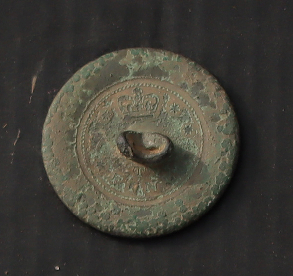
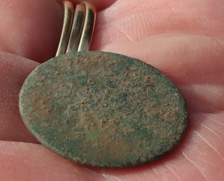
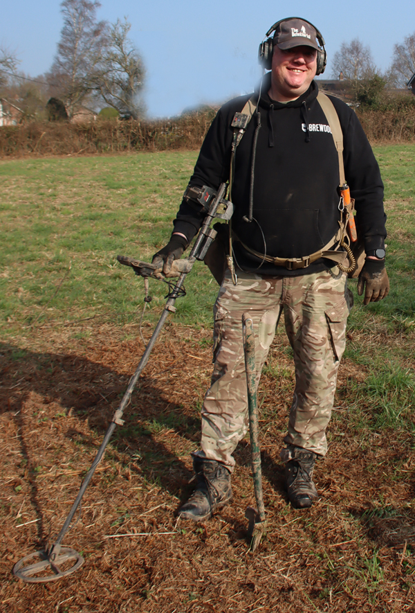
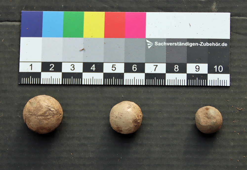
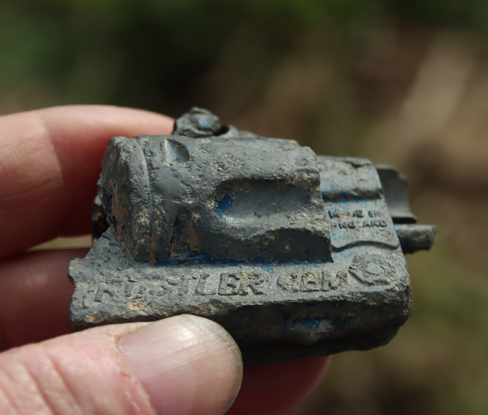
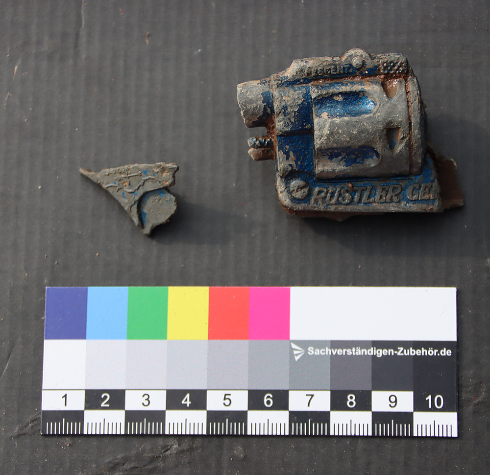
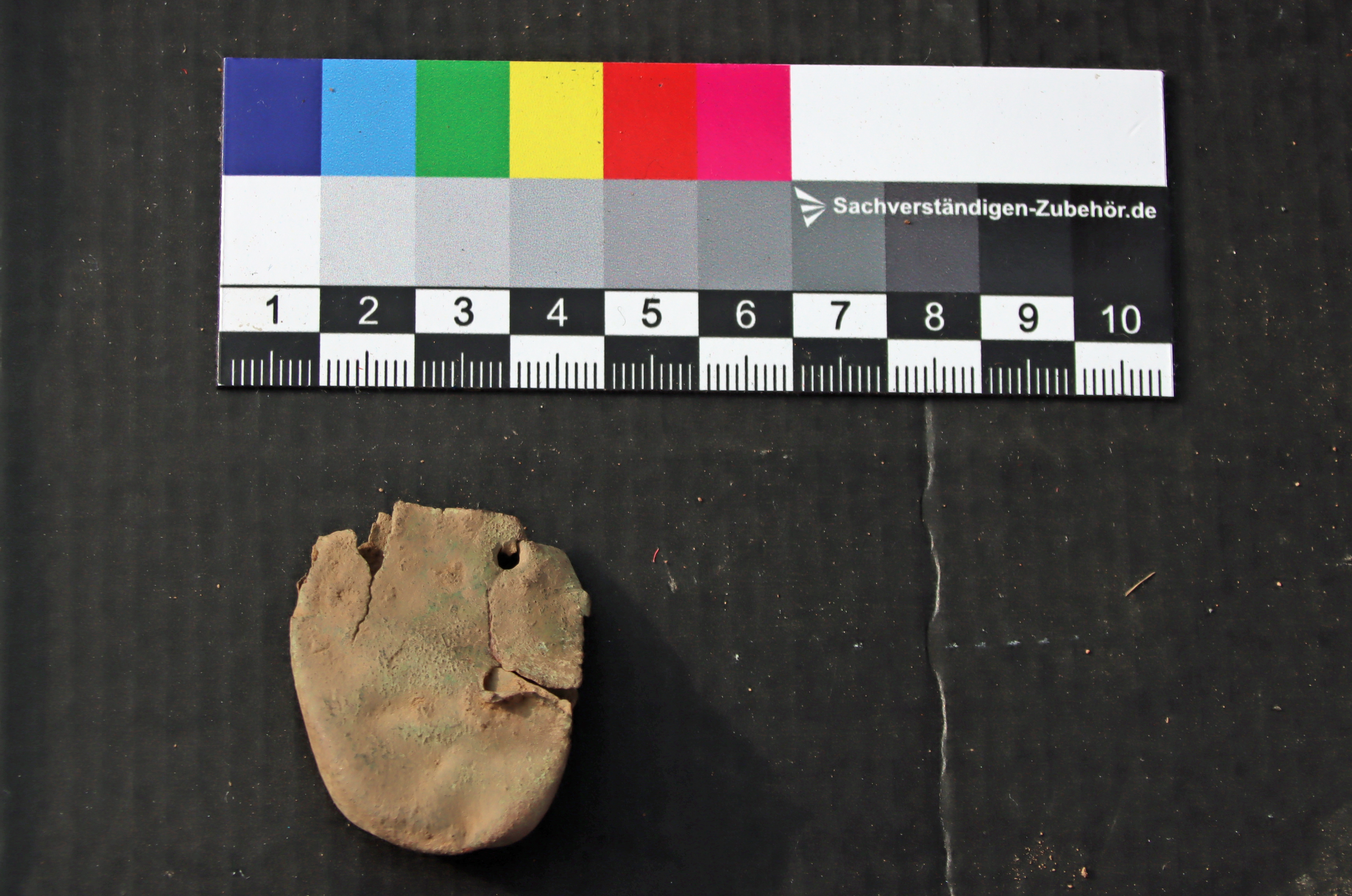
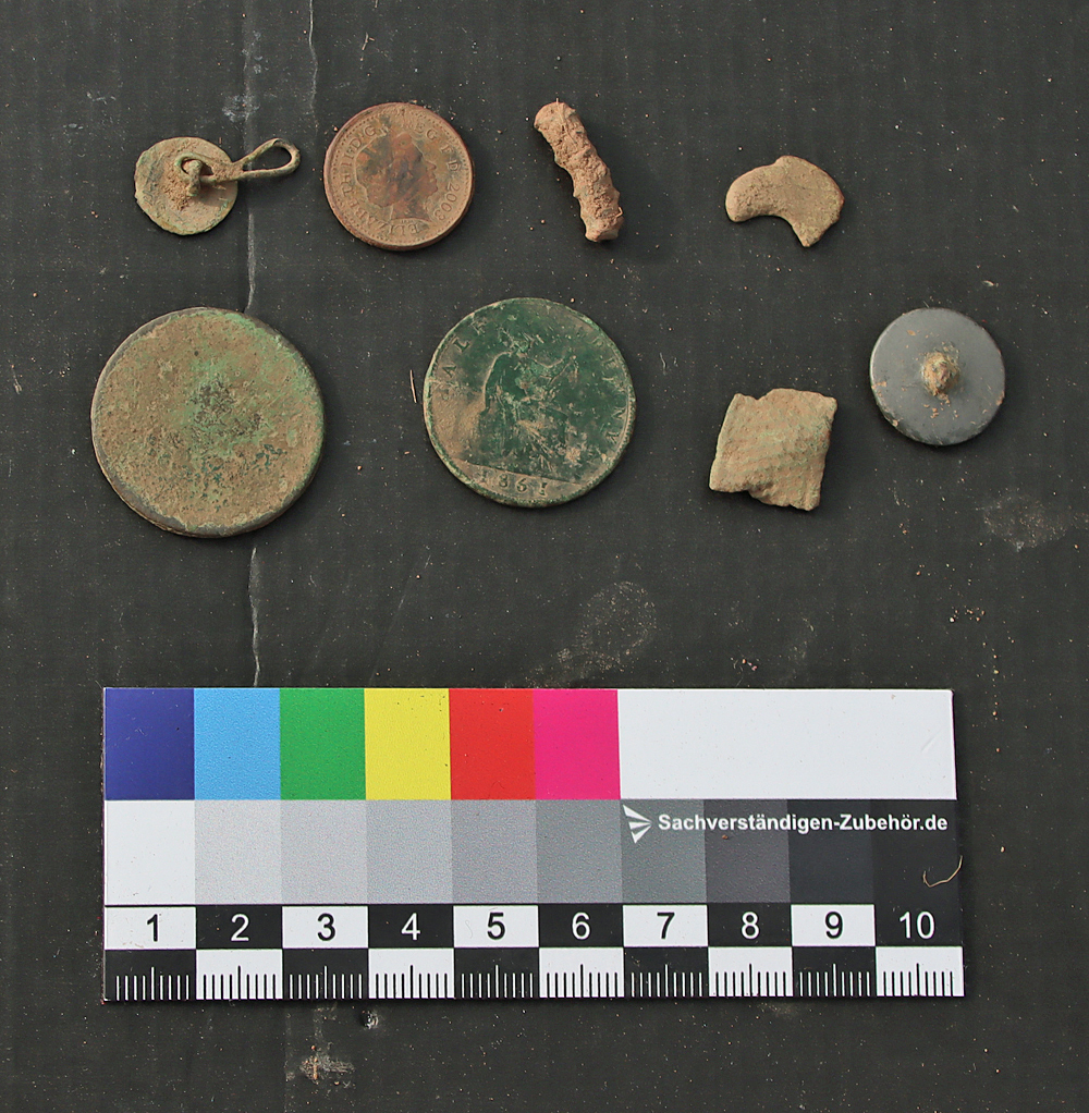
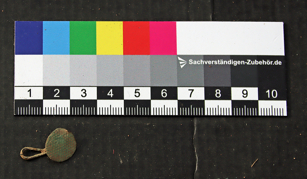
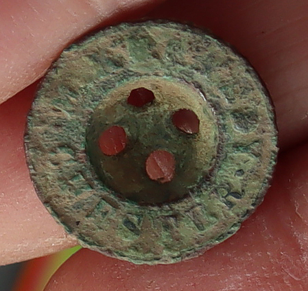
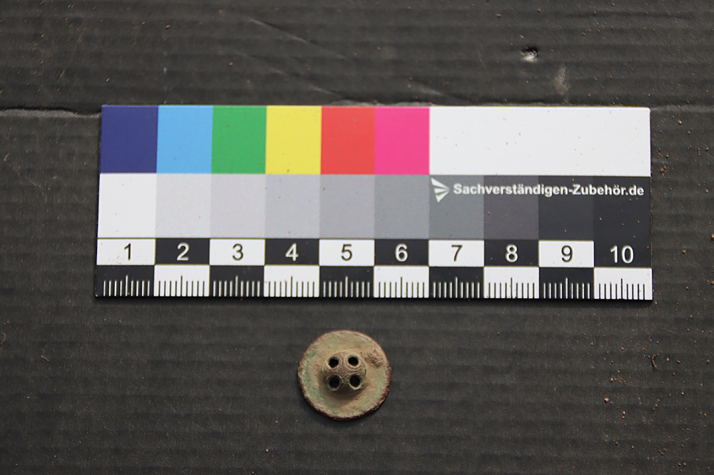
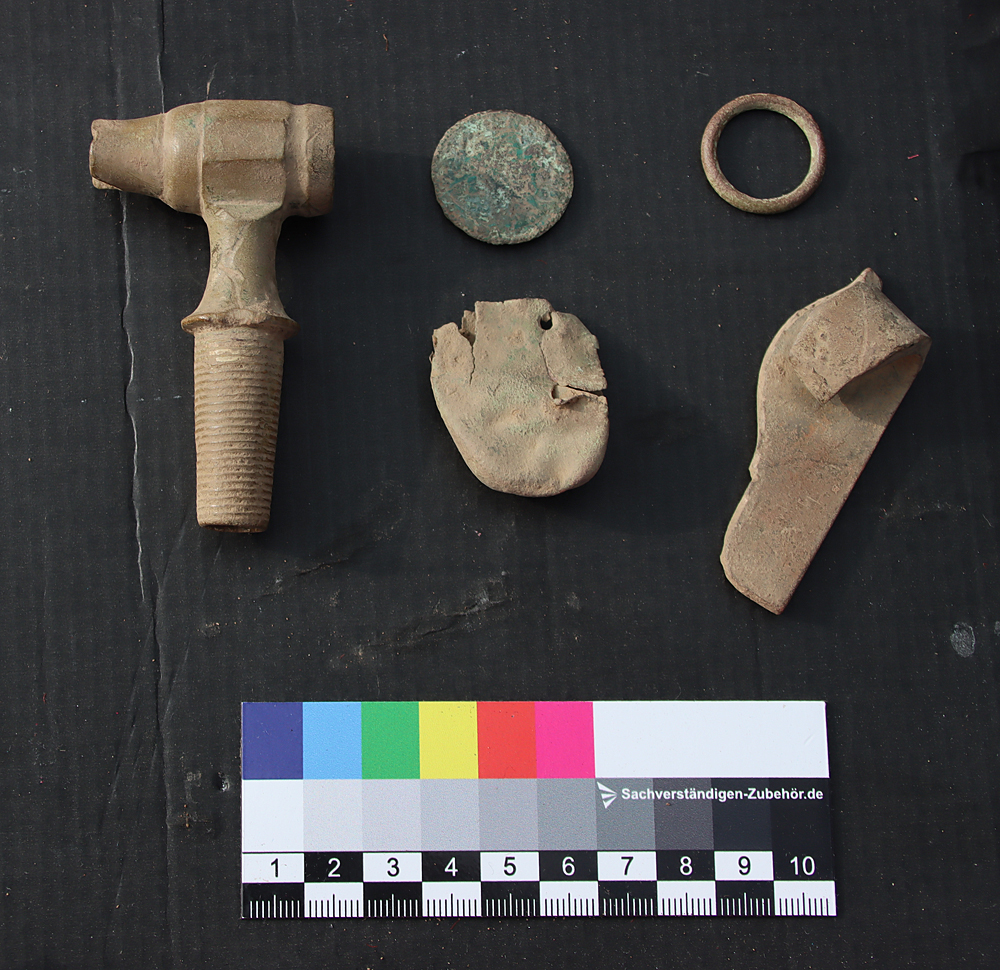
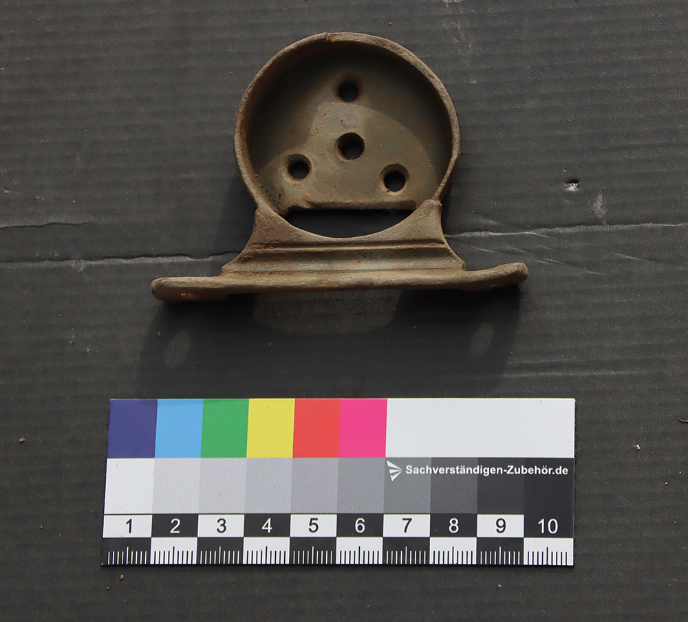
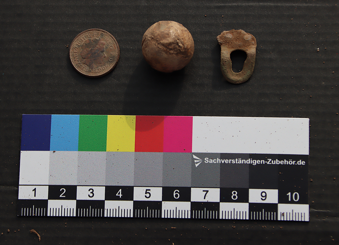
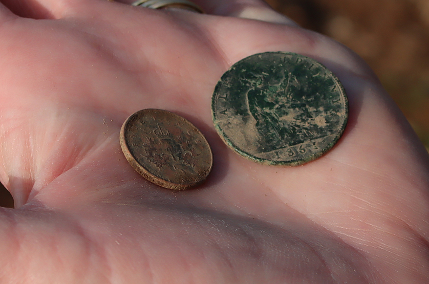
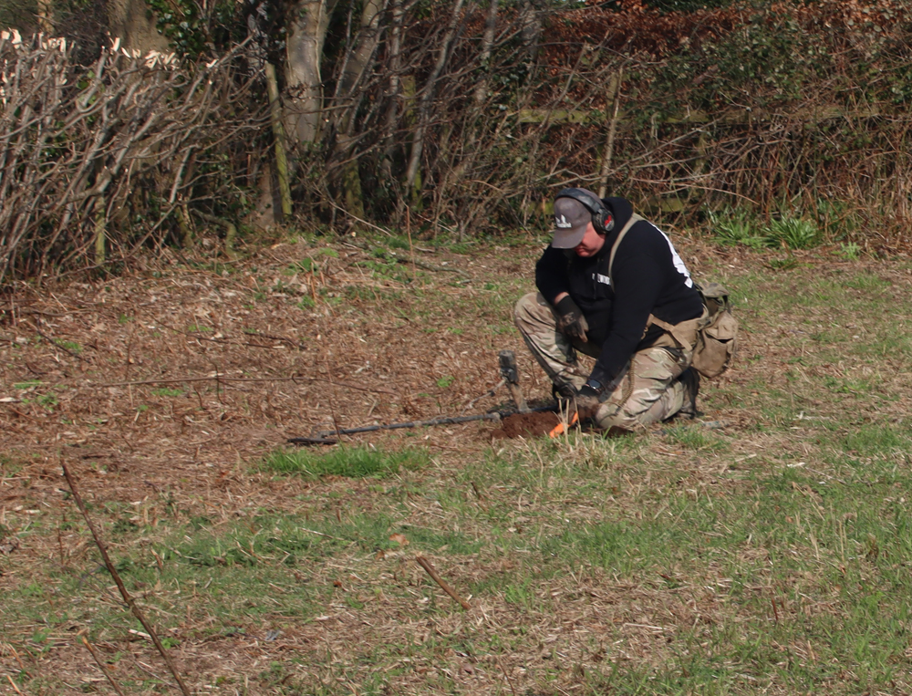

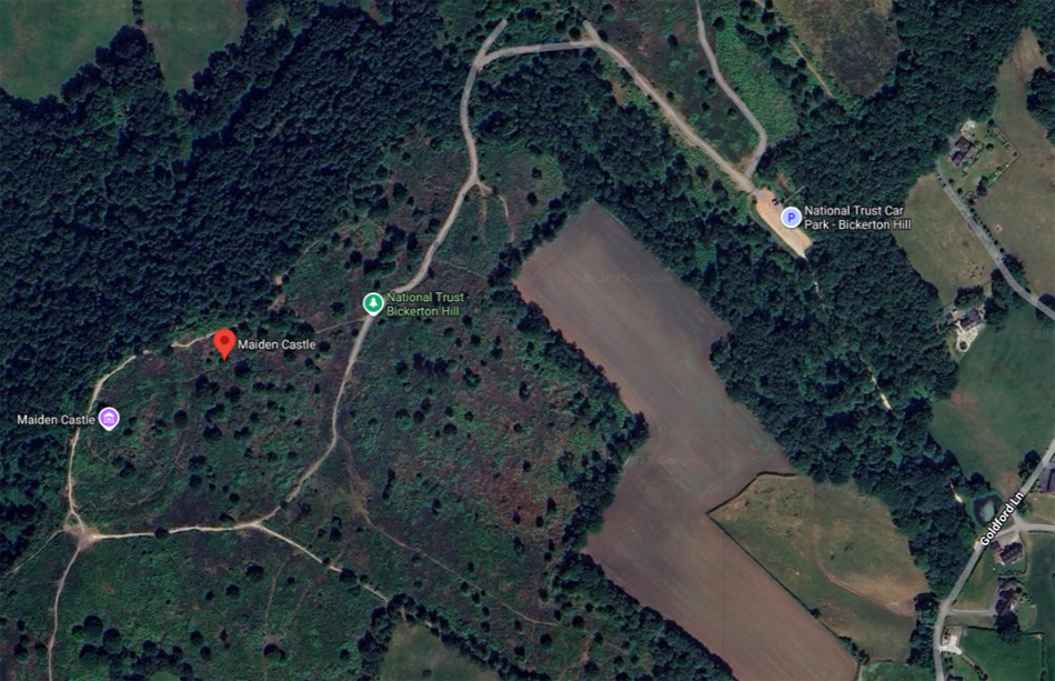


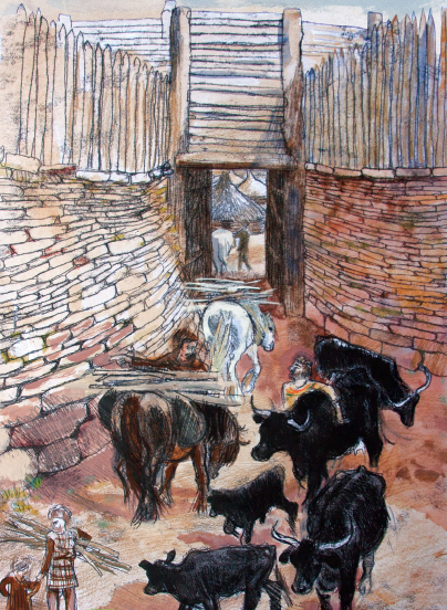


