Category Archives: Chester

Beeston Crag Prehistory #1 – The Earlier Prehistory

Beeston crag is a superb landmark, a small outcrop of the Cheshire Sandstone Ridge that was first occupied by people during the post-glacial period. Today, Beeston crag’s main claim to fame is the ruined 13th Century castle of Ranulf III, 6th Earl of Chester, built to intimidate his enemies, impress his allies, and provide himself with a magnificent legacy.  Following the Ranulf III’s death in 1232 and the subsequent death of his heir in 1235, the castle was repaired and rebuilt on several occasions until the 17th century when it was deliberately destroyed.  After this, the romance of the ruins attracted artists and tourist alike.  Today it is managed by English Heritage and is an engaging visitor attraction.  This has all been covered on two previous posts. Ranulf III’s Beeston Castle Part 1 looks at the remarkable magnate Ranulf III;  Ranulf III’s Beeston Castle Part 2 describes the castle’s history and includes notes about visiting.
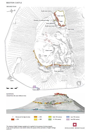
Beeston Castle, showing the excavated Bronze Age and Iron Age posthole locations, marking hut circles in the outer ward (pink circles).  The outer ward fortifications followed some of the lines of the Iron Age defences and the earlier Bronze Age banks.  Both contemporary and earlier prehistoric sites were also found in other parts of the site.  Source: Liddiard and Swallow 2007

Hidden beneath all of this rich Medieval and Civil War history is the archaeological story of the crag before history began.  The  impressive Medieval fortifications incorporate the remains of an invisible but remarkable prehistoric past, making the same use of a formidable location  that dominates the Cheshire plain, with clear views to the north, east and west, providing safety from predatory animals in what was dense woodland below.  Archaeologists between the 1960s and 1980s excavated these remains of the area’s prehistoric activity, some of it very exciting.

Although the Cheshire Sandstone Ridge as a whole is rich in prehistoric sites, in these two posts I simply want to get to grips with some of this particular crag’s prehistoric past.  I have divided Beeston’s prehistory into a post about the earlier  prehistory (in this part, part 1) and the later prehistory (in part 2).  Other sites on the ridge will be mentioned in passing, and future posts will discuss what all of the research on the Cheshire Sandstone Ridge contributes to our knowledge of prehistory in Cheshire.

For anyone wanting to find out more about each of the periods of British prehistory mentioned, some excellent books are listed in the Sources at the end of each of the two posts.

This post has been divided into the following sections:

  • Survey and excavation history
  • A note on the Three Age system
  • The role of the geology, geography and environment
  • The archaeological sequence at Beeston
  • Raw material acquisition at early prehistoric Beeston
  • Final comments
  • Next
  • Sources

Survey and excavation history

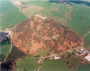
Aerial view over Beeston crag showing its prominent position over the landscape. Source: Sandstone Ridge Trust

Some of the hillforts on the Cheshire Sandstone Ridge were excavated in the mid-1930s by William Varley, an archaeologist with the University of Liverpool.  His excavations were focused on  hillforts, and although there were some inconsistencies is his approach, and his interpretations are sometimes questioned, he established that there was information under the ground along the ridge, and that it was worth investigating further.  Varley bypassed Beeston, but thirty years later new excavations filled this gap, focusing on both prehistoric and Mediaeval remains, a suitable endorsement of Varley’s initial exploratory work.
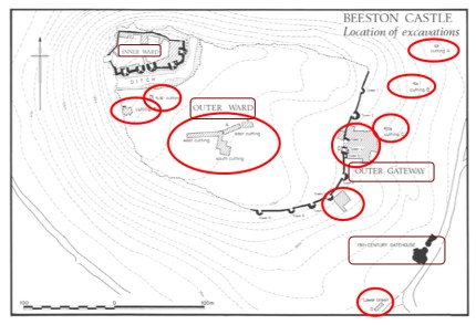
In the excavations of the 1960s-80s there were two main concentrations of excavation, one in the centre of the outer ward, and another by the outer gateway. Another fairly large area was opened to the south of the outer gateway, and some small cuttings were opened in other areas. Source: Ellis 1993 (with red circles added)

Two closely connected stretches of investigation are responsible for our understanding of the prehistory of the Beeston.  These are Laurence Keen’s work between 1968 and 1973 and Peter Hough’s work between 1975 and 1985.  These excavations found evidence of early as well as later prehistory, and made use of radiocarbon dating to establish a sound chronological sequence.    The account on this blog post makes extensive use of those excavations, reported in Beeston Castle, Cheshire. Excavations by Laurence Keen and Peter Hough, 1968-1985 edited by Peter Ellis and published by  English Heritage in 1993. Unfortunately, many of the tables and images were on microfiche, and although the core text is now available for download, the microfiches have presumably not been digitized.
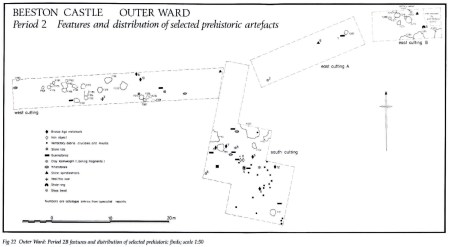
Plan of the Outer Ward excavation findings. Source: Ellis 1993

Although a lot of interpretive schemes in archaeology extrapolate from very small samples of big sites, particularly hillforts, in the case of the Keen and Hough excavations, there were two reasonably large areas where the work was concentrated, a smaller but still significant trench and several useful cuttings to sample other areas within the locale.  It is by no means straightforward to collate all this information into a coherent narrative, even if that is actually desirable with this sort of sampling, but some very useful findings were reported.

Some of the results of one of the sub-surface surveys in 2010. Source:  an unpublished report, via Garner 2016.

No recent excavation has taken place at Beeston, but a series of geophysical and LiDAR (Light Detection and Ranging) surveys were carried out by the Habitats and Hillforts Project in 2009 and 2010, at the outer ward and outer gateway.  Although these produced no definitive results, they did identify some anomalies that could indicate where future excavation projects might concentrate their attentions.  Much of the Habitats and Hillforts work has been published.  Dan Garner’s 2012 short introductory booklet  Hillforts of the Cheshire Sandstone Ridge, which looks at multiple periods of occupation, is very useful for becoming acquainted with the Cheshire Ridge archaeology.  Garner’s 2016 academic volume Hillforts of the Cheshire  Ridge is of considerable value for understanding both previous and current survey and excavation works at the other Cheshire Sandston Ridge sites in greater detail, particularly Eddisbury Hillfort.

A note on the Three-Age system
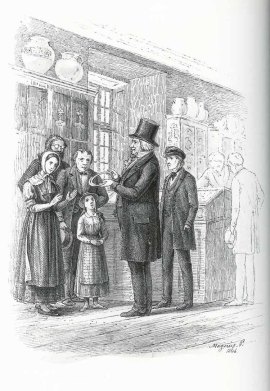
Thomsen explaining the Three-age System in Copenhagen, 1846. Drawing by Magnus Petersen, Thomsen’s illustrator. Source: Wikipedia

The 19th Century vision of a Three Age System, (Stone Age, Bronze Age and Iron Age), devised by Danish antiquarian Christian Jürgensen Thomsen and published in 1836,  was a spirited attempt to create a chronological framework for Danish prehistory that was widely adopted.  It became associated with the idea that technological innovations were inextricably linked to human progress and, by extension, the superiority of industrial nations.

Although ideas have now changed, the Three Age system is still the main organizing framework within which prehistory is discussed.  Having noted that the early Neolithic (New Stone Age) is an extension of the Mesolithic (Middle Stone Age), that the later Neolithic segues into the Early Bronze Age, as does the later Bronze Age into the early Iron Age, it is possible to move on.  These issues are all dealt with comprehensively in the academic literature.  The Three Age model still provides a framework within which most prehistoric archaeology is bashed out and bullied into shape, and as long as its limitations are kept to the fore, it need not be a wholly unyielding strait-jacket.

The role of geology, geography and environment
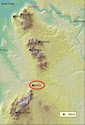
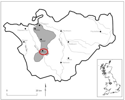
The location of Beeston within the Cheshire Sandston Ridge. Source: Garner 2012 (with red ring added)

Beeston is part of the fabulous Cheshire Sandstone Ridge, and those who selected it as an ideal place to settle, either temporarily or in the long-term, were presumably attracted by its height 150m above sea level, its location in a vast area of mixed deciduous woodland and, eventually, its defensive potential.

From a distance this prominent piece of geology looks like a complete anomaly, rising like a fossilized dinosaur’s spine out of the Cheshire Sandstone Ridge, knobbly and incomplete, but obviously the product of the same geological engine, the rocky components of the same machine.  Beeston sits towards the southern end of the ridge.  The Cheshire plain spreads from its base in all directions, the hills of the Welsh foothills to the west and the Peak district to the northeast, visible only in the far distance.  The Cheshire Sandstone Ridge is made up of desert sands and pebbles up to 225 million years old.  Questions about how the ridge formed and why it looks as it does are going to have to be the subject of a future post, written by someone else, but its upstanding presence in the otherwise flat landscape tell us, on its own, something about the prehistoric communities that, on and off over a period of nearly 8000 years, decided that it was a good place in which to camp or settle.
Archaeologically speaking, the sandstone composition is interesting because sandstone does not contain any of the stone types used used for the manufacture of stone tools.  This means that the flint and chert used for such tools was brought here from somewhere else.  This suggests not only that people were here for something other than the raw materials for tool manufacture but that they had to bring either the stone for tool manufacture with them, or the tools themselves.
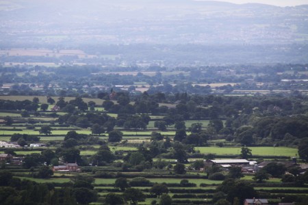
View from Beeston crag today west towards the Welsh foothills. In the Mesolithic and early Neolithic this would have been dense woodland. Clearance on the plain started in the later Neolithic but probably did not make significant changes to the patterns of vegetation until the mid Bronze Age to early Iron Age.

What the Cheshire Ridge has in abundance, other than sandstone, is height.  This provides truly impressive visibility across the landscape, as well as respite from the dense woodland below.  Whether or not the views across the plain would have been much use in earlier prehistoric phases is debateable, as the dense woodland would have disguised the approach of any but the largest groups of people.  Even after extensive woodland clearance had carved out agricultural fields,  this might have remained true.  On the other hand, lines of sight to other communities on other parts of the ridge might have been important, and clear views of weather fronts could also have been value.  Respite from dense woodland may have been relevant, especially when brown bear and wolves stalked the plains in hunt of meat of any description.  The best way to avoid becoming something else’s dinner is always to remove oneself from its preferred habitat.  It’s not a fool-proof strategy, but it’s certainly a step in the right direction.
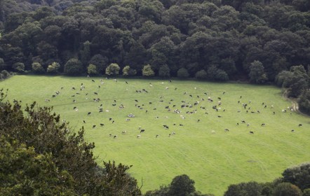
Cattle grazing in a field below Beeston.

According to the Sandstone Ridge Trust, farming remains the major land use, with livestock farming dominating the area.  This is interesting, as it tends to confirm the general impression that the damp clays of the Cheshire plain would have been difficult to cultivate in the past, particularly in early prehistory when the environment was much wetter and the area around the ridge included a network of freshwater springs.  Woodland cover today exceeds 13%, which is high compared to nearby areas, but low compared to the probable coverage throughout most of prehistory.

A multi-period location
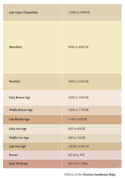
Archaeological chronology of the Cheshire Sandstone Ridge. Source: Garner 2012

Wherever there is a medieval castle perched on a hilltop, it is worth looking for an Iron  Age hillfort.  They are often there to be found.  It is also worth looking even further down the chronological funnel because some of the fortified prehistoric hilltops once synonymous with the Iron Age, are now known to have been built centuries before the Iron Age began.  So wherever there is an Iron Age hillfort, it is worth bearing in mind that there may be a late Bronze Age predecessor, as was the case at Beeston.   At Beeston the two phases of Iron Age hillfort were preceded by two phases of later Bronze Age settlement, one of which included an enclosing bank, and these were themselves preceded by even earlier prehistory – the Mesolithic, Neolithic and Early Bronze Age.

On the basis of previous work in the area, the excavators may have been hoping for prehistoric as well as Medieval finds, and they found evidence from the Mesolithic occupation from around 8000BC, dotted around all the way to the Romano-British period, which in Cheshire dates to c.70AD.  These were small outposts of earlier prehistoric activity Mesolithic (Middle Stone Age), Neolithic (New Stone Age) and Early Bronze Age, as well as more comprehensive discoveries of the later Bronze Age and Iron Age.  The earlier prehistoric phases will all be discussed below and the later prehistoric in Part 2.  Although there were discontinuities between the various occupations of Beeston, the crag was clearly of value to people of very different economic and social profiles over a very long period of time.
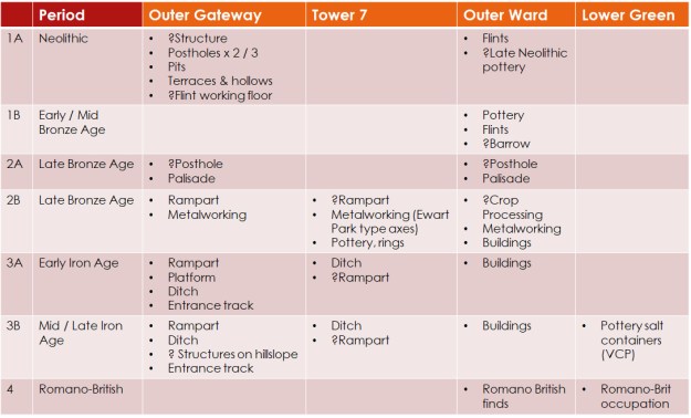
Archaeological periods at Beeston crag. Collated from Ellis 1993.

The Archaeological Sequence at Beeston

After the Ice Age, 9000-4000BC
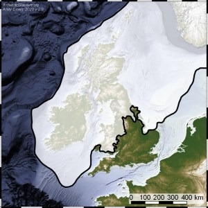
Maximum extent of the Devensian ice-sheet. Much of the rest of southern England will have been encased in permafrost which only began to melt as the ice sheets retreated, starting at around 10,000BC. Source: Antarctic Glaciers

During the last Ice Age, the Devensian, glacial ice-sheets extended in an uneven line towards southern England, covering Wales and Ireland.  The ice sheets carved out the u-shaped valleys that we all remember from school geography lessons, transporting huge amounts of debris from north to south, dropping thick deposits of soil and gravel, and creating meltwater channels.  Vegetation was demolished either by the ice or by the temperatures, animals and people departed, and most of Britain was empty of life.  Connected to the continent by a substantial land bridge, Britain only began to revive when the climate started to warm, and the ice began to melt.  Vegetation, consisting of  deciduous woodlands, shrubs and grasslands slowly returned to the lowlands, followed across the land-bridge by, amongst others, red deer, wild cattle (aurochs), reindeer, elk, brown bear, wolf and lynx.  In their wake followed small communities of people who lived by hunting game, foraging for wild vegetables, roots, seeds, herbs and fruit, and fishing on the coast and in rivers.  Today the period during which these groups of people returned and occupied post-glacial Britain is known as the Mesolithic, or Middle Stone Age. As the ice continued to melt and sea levels continued to rise, Britain was eventually physically cut off from the mainland, but that did not prevent other types of connection being established.
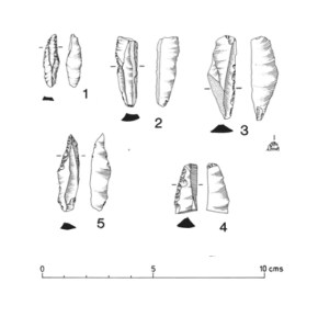
Mesolithic tools found from Beeston Castle, all less than 5cm long. Source: Ellis 1993

The Beeston Mesolithic finds are restricted to a small handful of stone tools that had been dislodged from their original context.  These are very typical of the period, consisting of microliths (tiny stone tools), and other very small pieces.  They do not say much on their own, but other Mesolithic sites in the area argue that the Beeston finds are a very small part of a much bigger Mesolithic story in the area.  In particular, Harrol Edge near Frodsham produced over 1500 tools from the period and will be discussed further below.  Other small sites are dotted along the Cheshire Ridge although most are as ephemeral as those at Beeston.  These include an earlier and later Mesolithic phase at Carden Park near Broxton; Riley Bank Farm, Alvanley Cliff (all at the northern outcrop); and Seven Lows on the east edge of the central outcrop (a Late Neolithic/Early Bronze Age site where around 100 pieces of worked flint were found).  These are all surface scatters, not clearly defined and stratified sites, but they are valuable for indicating the presence of people at this time, suggesting the size of  individual occupations and the period of time over which visits were made.  Together, they argue for small, temporary stopping off points as the landscape was exploited for food, craft and tool manufacturing resources.  They combine with other evidence to give an impression of a very busy pattern of landscape use in the Cheshire Ridge area, probably on a seasonal basis.

The Neolithic, 4000-2500BC

The later Mesolithic did not come to an abrupt end, any more than the Neolithic began as a rocket launch.  The long period of transition between the two livelihood strategies were influenced by processes taking place on the continent, themselves innovated in the Near East.  These presented opportunities and options, perhaps attractive to some and not to others, and take-up was no overnight phenomenon.
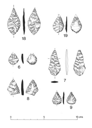
Neolithic stone tools from Beeston crag.  Numbers 18 and 19 at the top of the image are earlier Neolithic leaf-shaped arrowheads. Source:  Ellis 1993.

The changes that help to define the Neolithic (New Stone Age), when they began to gather momentum in around the third millennium BC, were characterized by a number of transformations that took place over the following 2500 years.  The spread of the main features generally characterizing the Neolithic did not spread at the same rate throughout Britain, and not all characteristics were adopted at the same time, even in neighbouring areas.  The main components defining the Neolithic are new forms of technology, a change of food acquisition practices, accompanied by new types of social statements.  Continuities and discontinuities between the Mesolithic and Neolithic are eternally under debate, because they are central to the question of how the domesticated crops and livestock, stone tool technology and more nebulous spiritual ideas were introduced from the continent, adopted in Britain and then spread.  Whatever the mechanism of their arrival in Britain, they became cornerstones of everyday life, and eventually found throughout Britain and Ireland, taking different forms in different areas, but based on a similar package livelihood opportunities, both economic and conceptual.

Early Neolithic of the Grimston/carinated tradition in northern Britain. Source: Malone 2001.

In parts of Britain, the Neolithic represents the first foray into mixed agriculture, with domesticated cereal crops and livestock and the adoption of pottery, which helped to introduce new cooking techniques, and to increase the variety of foodstuffs that could be consumed.  It also improved storage of both solids and liquids, protecting them from insect and vermin, and  took on cultural as well as economic roles. It is possible that after an initial foray into cereal production, pastoralism became the dominant approach to Neolithic food production.  This was probably particularly true in areas like Cheshire, where the clays, meres, mosses and heathlands would have been anything other than ideal for crop cultivation, and where dairy and other livestock farming dominate today.

As people began to manage their livelihoods in new ways, novel ceremonial and funerary monuments were built, and pottery and stone tools began to enter the realm of the dead as well as the living.  Long distance relationships, already a feature of some Mesolithic communities, extended, as the trade in axes and exotic materials expanded.
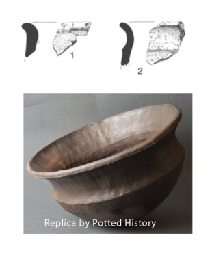
Grimston Ware sherds from Beeston (Royle and Woodward in Ellis 1993). The lovely replica showing what a complete carinated Grimston bowl would look like, is by Potted History

Information about the Neolithic in Cheshire, and particularly the Cheshire Ridge, is at best fragmentary, and it is not yet possible to pull together a coherent narrative of what is happening.  As with the Mesolithic, settlement data, rarely in the form of structural remains and usually in the form of  secondary scatters of objects on the surface, are generally small and dispersed but together contribute to  distribution maps to indicate, at the very least, where Neolithic people were present, and what form their presence took.  

At Beeston, objects of both the earlier and mid Neolithic were placed by Ellis in his 1A phase.  Objects diagnostic of the earlier Neolithic include leaf-shaped arrowheads (above), and carinated bowls (right) that used to be referred to as Grimston or Grimston-Lyles Hill ware, generally in circulation from c.3750BC.  The carination here is the rim that circles the centre of the vessel, and in general refers to a vessel’s wall making a sharp change of direction.  At Beeston both leaf-shaped arrowheads and sherds of carinated bowl are present, although the pottery is very fragmentary.  Because clay was fired at relatively low temperatures, and because temper in the fabric was often organic or composed of stone pieces, the pots were relatively fragile and once abandoned, were vulnerable to frost and heat damage and to erosive forces.  It is therefore comparatively rare to find Neolithic pottery found in tact.  Although Grimston carinated wares continued to be used for hundreds of years in some areas, in most they were replaced by more regionally distinct styles. 

The leaf-shaped arrowheads that were spread widely through Britain had no antecedents in the Mesolithic, they suggest that hunting still formed part of subsistence activities.  The hand-made (as opposed to wheel-thrown) carinated pottery.  Carinated bowls were found in a wide range of contexts in Britain, from pits and middens to early burial contexts, but there is no evidence of burial sites of this date either at Beeston or nearby.
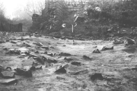
The early to mid Neolithic phase at Beeston’s outer entrance under excavation. You can see the stone walls of the Medieval castle in the background. This area is at the entrance to the outer ward, so when you pause to walk through the gap in the walls, remember that a Neolithic site was found underfoot. Source: Ellis 1993.

Another area of Neolithic at occupation at Beeston was found during the excavation at the outer gateway to the Medieval castle.  The Neolithic phase in this area was marked by terraces, hollows, pits and postholes.  There had clearly been an attempt to provide a level surface, implying some investment in the site, suggesting either the intention to stay put for some time, make repeat visits annually, or return at seasonally.  As well as this evidence of settlement, there were stone tools including small axe heads and the sherds of four types of Neolithic pottery, spanning the early to mid Neolithic. 

Additional Neolithic material was found on the plateau edge.  A deep pit cut into the bedrock and a smaller pit or posthole were accompanied by a single early-mid Neolithic sherd, at the base of the deep it.  It is difficult to assess, but the excavators suggest that it may mark a former entrance.  Finally, a single Late Neolithic sherd was found in Post-Medieval layers in the outer ward, where the Bronze Age and Iron Age hut circles were found.

Were these Neolithic occupants permanent cultivators who carved out fields in the woodland below, peripatetic livestock herders, or occasional visitors making use of the outcrop as a supplement to activities on the plain or elsewhere?  There are no plant or animal remains surviving to give us a hint.  The evidence from pollen analysis indicates that post-glacial Beeston developed in the context of mixed oak woodland and Ellis says that pollen data from north of Beeston suggests an initial clearance phase, but that this did not happen until the third millennium (i.e. between 3000BC and 2000BC, in the later Neolithic).   At Eddisbury hillfort, excavations in 2010 produced wood charcoal and other vegetation remains that suggest heath or moorland conditions that are generally associated with human manipulation of the landscape, in particular livestock grazing.  It is possible that the ridge outcrops were being used for seasonal upland herding activities.  Patches of grassland would have been ideal for grazing sheep, and coarse shrub for browsing goat, whilst cool woodland on the plain, particularly oak with its acorns, would have suited pigs perfectly.

Neolithic worked tools from Beeston Castle. Source: Liddiard and Swallow 2007

There are other explanations possible as well.  The small size of the assemblages may suggest scouting parties or small detachments engaged in resource aquisition tasks, heading east to west or north to south, and heading up hill for safety en route somewhere else.

All of the above is pure speculation, based on livelihoods practiced elsewhere, but it is the sort of speculation that ensures that when new data emerges, different models of occupation can be tested against the cumulative findings.

Although ceremonial and burial monuments are characteristic of some regions, nothing of this sort on the ridge or, to date, in the immediate landscape have been found in the early/mid Neolithic. Not until right at the end of the Neolithic and the beginning of the Early Bronze Age, when round barrows begin to appear on the sandstone ridge, and beaker remains were found at Beeston.  This is at least 2000 years after the leaf-shaped arrowheads that we looked at above.  I’ve covered beakers and round barrows in the Early Bronze Age section below, although they might just as well be termed Late or Final Neolithic.

Although only a small area of Neolithic land modification was identified, and there are only a handful of artefacts, it is worth remembering that only a small part of the entire crag was sampled.  That’s not anyone’s fault, because it would take decades to dig up the entire thing.  The excavation sample was actually impressive, and it does mean that there may well be other examples Neolithic land modification and objects to discover both on Beeston and other outcrops, as well as in the surrounding landscape.  Although it’s a trite analogy, every new site, however small, is an important part of the Neolithic jigsaw, not only allowing insights locally, but contributing to how we understand differences from and linkages between geographical areas in Britain.  Fortunately, excavation programmes are ongoing under Habitats and Hillforts Project and as all of this Cheshire Sandstone Ridge data is collated, it will hopefully provide an increasingly coherent understanding of Neolithic livelihoods on parts of the ridge and the surrounding area.

Early Bronze Age / Beaker period c.2500-1700BC
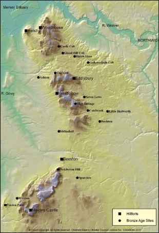
Earlier and Later Bronze Age sites along the Cheshire Ridge. Source: Garner 2012

In most parts of the country there is no clear delineation between the Late Neolithic and earliest version of the Bronze Age, sometimes referred to as the Copper Age or chalcolithic (roughly, the copper stone age) because copper appeared before bronze was introduced.  A new type of pottery, the Beaker, is also characteristic of this cross-over period, together with a range of associated objects.

It has been clear to archaeologists for a long time that the Beaker tradition was communicated to Britain and Ireland from the continent, where its geographical presence was widespread, found in Netherlands, Belgium, Germany, France, Italy, and the Iberian peninsula.  A  multi-disciplinary DNA analysis research project in 2017 proposed that a significant percentage of the indigenous population of Britain was, by the Middle Bronze Age, replaced by those who brought the Beaker tradition with them at the end of the Neolithic. Here’s an excerpt from the report (Olalde et al 2017).

The arrival of the Beaker Complex precipitated a profound demographic transformation in Britain, exemplified by the absence of individuals in our dataset without large amounts of Steppe-related ancestry after 2400 BCE. It is possible that the uneven geographic distribution of our samples, coupled with different burial practises between local and incoming populations (cremation versus burial) during the early stages of interaction could result in a sampling bias against local individuals. However, the signal observed during the Beaker period persisted through the later Bronze Age, without any evidence of genetically Neolithic-like individuals among the 27 Bronze Age individuals we newly report, who traced more than 90% of their ancestry to individuals of the central European Beaker Complex. Thus, the genetic evidence points to a substantial amount of migration into Britain from the European mainland beginning around 2400 BCE.
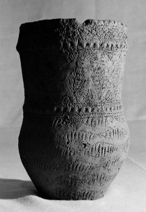
Cheshire’s only complete beaker, from Gawsworth. Source: Megalithic.co.uk

As is so often the case with this sort of DNA research, as highlighted in the study itself, there are questions remaining about the extent to which it is possible to extrapolate from the data used, including sampling issues (statistical, geographical and relating to the quality of the material).  However, although the question about how and why the continental Beaker objects and ideas became so popular remains open to some extent, it seems probable that as well as cultural dispersal of ideas and practices, some level of migration took place.  However it happened, at the end of the Neolithic the continental Beaker and associated objects did become desirable, and were found extensively under round barrows, as well as occasionally in other contexts, in many parts of Britain.  The cultivation of cereals also appears to have been resumed in some areas and intensified in others at this time, with new roundhouses being built in domestic contexts.

Distribution of some of the round barrows in Cheshire. Source: Morgan and Morgan 2004.

Beakers are not as common in northwest England as they were in the south, and only one complete Beaker, a long-necked type, has been found in Cheshire, in a round barrow burial Gawsworth, which is in the far east of the county, near Macclesfield.  The Beeston Beaker-related finds fall within Ellis’s 1B phase.   They were found at the Outer Gateway and in the Outer Ward.  In all cases they were found in amongst later material, within later prehistoric and Medieval material and postholes.  They consist of Beaker fragment, collared urn and/or pygmy cup fragments, a barbed and tanged arrowhead and four knife blades.  In Ellis’s collation of the excavations by Keen and Hough, the pottery analysis by Royle and Woodward interpreted the Beeston Beaker and its associated finds, as evidence for a vanished barrow burial.  There has been extensive use of the outer wards since prehistoric times with considerable quarrying and levelling on all areas of the plateau, so it is not impossible that a round barrow had been built and later destroyed. Beakers could, however, also be found as broken sherds in isolated pits, as well as in domestic contexts.  Other new forms of pottery followed in the Early Bronze Age, including food vessels, cordoned urns, collared urns and pygmy/accessory cups, of which a number of examples have been found along the Cheshire Ridge.
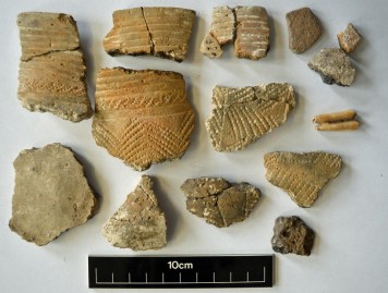
Seven Lows assemblage with Beaker sherds. British Museum 1862,0707.64. Source: British Museum

Round barrows with Early Bronze Age finds in them have been found in the Cheshire Ridge area.  Examples shown on the map above are Carden Park at Broxton, Castle Cob, Glead Hill Cob, Peckforton, High Billinge, Little Budworth and the Seven Lows barrow cemetery.  Few have been excavated in modern times, but most were cremations.  Only Clead Hill produced metal, in the form of a single bronze pin.  It was accompanied by two barbed and tanged arrowheads, collared urns and a pygmy/accessory cup, all consistent with Early Bronze Age burial assemblages.  The most common form of metal dating to the Early Bronze Age in the area was in the form of isolated finds of flat axe heads, but there are only four of those in the general vicinity.  The recent excavation report for Seven Lows has just been reported (it arrived through my letterbox yesterday) by Dan Garner in the Journal of the Chester Archaeological Society, so there will more on that site on a future post.

There is even less information for the Beaker-related presence at Beeston than the Neolithic, but what has been found is not inconsistent with other finds in the area, and it is to be hoped that further excavation will lead to a more complete understanding of the Beaker tradition in the Cheshire Ridge area.


Raw material acquisition at early prehistoric Beeston

Sourcing stone

Flint and chert were the materials used by the tool makers who left their tools at Beeston Crag.  Because of the way in which the stone fractures predictably when hit by a hard or soft object, flint and chert are favoured for flaked stone tool manufacture.  A remarkable amount of precision is achieved, meaning that multiple classes of foot types can be manufactured which, once identified by archaeologists, can be categorized and can contribute to an understanding of livelihood transformation and regional differentiation.

Mesolithic flint and chert tools from the Adams collection, collected at Harrol Edge, Frodsham. Source: Brooks, in Garner 2016

The sandstone ridge was not the source of the raw materials used in the earlier prehistoric period for stone tool manufacture.  At  Harrol Edge, near Woodhouse Hill at Frodsham, over 1500 pieces of Mesolithic worked stone pieces were gathered during unofficial fieldwalking in the 1950s by local resident J. Adams, since donated to the Grosvenor Museum in Chester.

For the flint, an analysis of the Harrol Edge tools by Ian Brooks identifies two sources, in chalk deposits of the Lincolnshire/Yorkshire wolds or Northern Ireland.  This does not necessarily mean that people had to go to either place or engage in trade to source the stone, because the ice-sheets transported considerable amounts of stone material to parts of the country to which it was not native, and Irish Sea till (unsorted material deposited by the movement of glacial ice) and associated gravels have been found in the valley of the River Weaver, which runs to the east of the sandstone ridge.

The nearest chert deposits were found in limestones in the Peak District and on the edge of the Vale of Clwyd (sometimes referred to as Gronant chert but properly part of the Pentre Chert Formation).  This means that however these stones were being sourced, they had to be transported to the site either as a raw material for working into tools, or as finished objects.
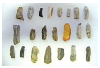
More Mesolithic stone tools from Harrol Edge, Frodsham. Source: Garner 2012

Hunter-forager-fishers of the Mesolithic were seasonally mobile, moving base camps to make the most of food and craft resources.  It is more than probable that in their seasonal rounds they were able to source chert and flint.  There is insufficient evidence from Beeston itself to suggest how stone was being processed, but of the 1500 pieces from the Harrol Edge collection, only 266 were actual artefacts, consisting of 232 blades and 34 scrapers, and the rest were by-products of the manufacturing process, representing multiple took making events.  This suggests that most of the artefacts were being made here, wherever the finished tools were eventually discarded, meaning that the raw material was brought to the site to be worked, rather than being worked where it was found.  Most of the objects were made on flint, mainly a distinctive banded variety, and only 8.6% were on a dark-coloured chert.  The chert tools may have been earlier in date than the flint examples.  Brooks says that the banded flint was not wholly ideal for knapping into shape, and probably would not have been the first choice if an alternative had been readily available.  Brooks felt that it probably came from the Peak District, but did not rule out north Wales as a possibility.
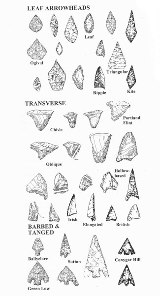
Knapped stone arrowheads from the Neolithic. Source: Malone 2001

In terms of the Neolithic stone use at Beeston, even early farmers were often far from sedentary, making their way through the landscape as they herded, seeking out craft materials on a seasonal basis and looking for new opportunities to exploit tracts of lowland and upland.  Early farmers were often far from sedentary, making their way through familiar landmarks of the landscape as they herded on a seasonal basis, seeking out craft materials on a and looking for new opportunities to exploit both lowland and upland environments.  It is possible that the local glacial tills provided the necessary flint for small tools, but even if travel had been required or the acquisition of raw materials, it would not have been necessary for the entire community to relocate.  For example, a dedicated resource acquisition group could have been dispatched from the group for this specialized task.  At the moment all we know for sure is that Neolithic groups were in the area, and that they imported flint and chert, either as raw material or as completed tools, from outside the area.

At Beeston the Early Bronze Age stone tool assemblage consists of a flint barbed and tanged arrowhead and four knives, all flint, and all nicely worked.  There is not much to be added to the above comments, but the knives were made of bigger pieces of flint than previous items, and it seems less likely that the raw material for such items would have been carried for any distances.  I have no idea whether or not flint pieces this size could have been found in the nearby valley gravels.

Sourcing materials for pottery
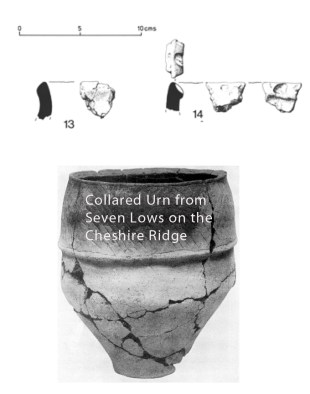
Collared urn sherds from Beeston (Royle and Woodward in Ellis 1993) and a photograph of collared urn from Seven Lows (source: Megalithic Portal)

The excavation report refers to three types of phase 1a and 1b pottery at Beeston.  All of them are made from local glacial drift clays characteristic of the Cheshire/Shropshire basin.  For example, the mineral inclusions (called temper) that were added to the collared urn clay during the pottery making process included quartz, sand, granite, rhyolite and basalt, all of which were common to other collared urns in Cheshire, and all of which could be sourced from local river valleys and glacial gravels in the area.  Because both the clay and the temper  were available locally, vessels could be manufactured within the immediate area, although there is no actual evidence to date for pottery manufacture at any of the Cheshire sites.  Although these vessels were hand formed rather than wheel-thrown, they still needed to be fired, and so far no evidence has emerged in the area for Neolithic kilns (usually simple pit kilns).


Final Comments

Although Beeston crag has produced the greatest evidence of early prehistoric occupation along the line of the Cheshire Ridge, this is probably due mainly to an accident of sampling.  Other hillforts were simply not excavated as extensively as Beeston, meaning that there could be plenty of early prehistory to be found at other Cheshire Ridge outcrops.  There have been some indications that there is more to be found.  At Eddisbury hillfort, for example, a possible late Neolithic cremation cemetery has been identified; at Seven Lows barrow cemetery at the eastern foot of the central outcrop, a recent excavation has just been published in the Chester Archaeological Journal (issue 8);  at Woodhouse  a small assemblage of Late Neolithic/Early Bronze Age stone tools were found, and at Helsby some early Neolithic activity has been identified.  Stray finds have been found elsewhere along the line of outcrops.
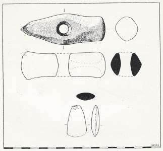
The so-called Beeston Hoard. Source: Varley and Jackson 1940

So far all the archaeological focus has been on the outcrops of the ridge, but that too is something of a sampling problem.  Because of the considerable agricultural value of the land across the Cheshire plain, it is unlikely that many upstanding sites are left to be found, and any settlement sites are likely to have been ploughed in. Aerial photography has proved to be of marginal value due to the water retentive properties of the glacial soil, which prevents it drying out sufficiently to show variations in the soil during dry weather.  However, there are hints that  prehistoric archaeology may yet be found.  On the plain not far from Beeston, the so-called “Beeston hoard” was found on the edge of a former freshwater spring, consisting of a Neolithic polished stone axe and an Early Bronze Age perforated stone axe-hammer.  The remains of a round barrow surrounded by a ring of stones and a circular ditch were found at Morreys garden centre at Kelsall, containing the cremated bones of a child in an inverted collared urn.  Unfortunately, discoveries like that have been few and far between.

Barbed and tanged arrowhead from Beeston – Late Neolithic/Early Bronze Age. Source: Ellis 1993

The discovery of earlier prehistoric sites along the course of the Cheshire Sandstone Ridge, many only excavated only briefly and some not excavated at all, establishes that there is the opportunity for further investigation, and hopefully further illumination.  There are a lot of questions remaining open about the earlier prehistory of both the ridge and the surrounding landscape.  Clearly, there is a lot of future potential for both non-invasive survey and excavation, should the funding be available.

Next

Following a visit to Beeston to enjoy the castle on a fine, sunny day last year, I became aware that Beeston had something of a prehistoric past, but I was surprised by how rich that past turns out to be, particularly when seen within the context of other sites on and around the Cheshire Sandstone Ridge.  At Beeston it begins with the Mesolithic occupation from around 9000BC, and then takes in the early Neolithic and the later Neolithic/earlier Bronze Age.  In Part 2, the very striking Bronze Age and Iron Age round-house and related discoveries on the Beeston crag take us all the way to the Romano-British period.


Sources for Parts 1 and 2:

Items in bold were used extensively in this post, with my thanks.

Books and papers:

Berridge, P. 1994. The Lithics.  In (ed.) Quinnell, H., Blockley, M.R. and Berridge, P. Excavations at Rhuddland, Clwyd, 1969-1973. Mesolithic to Medieval.  BAR 95, CBA.

Bradley, R. 2019 (2nd edition).  The Prehistory of Britain and Ireland. Cambridge University Press

Callaway, E. 2018.  Divided by DNA: The uneasy relationship between archaeology and ancient genomics.  Nature, March 28th 2018

Cunliffe, B. 1995. Iron Age Britain. English Heritage/Batsford

Cunliffe, B. 2005 (4th edition). Iron Age Communities in Britain. Routledge

Ellis, P. (ed.) 1993.  Beeston Castle, Cheshire. Excavations by Laurence Keen and Peter Hough, 1968-1985. English Heritage
https://archaeologydataservice.ac.uk/archiveDS/archiveDownload?t=arch-1416-1/dissemination/pdf/9781848021358.pdf 

Fairhurst, J. M. 1988.  A Landscape Interpretation of Delamere Forest. May 1988
http://delamereandoakmere.co.uk/wp-content/uploads/2017/03/fairhurst-delamere-landscape.pdf

Garner, D. 2012.  Hillforts of the Cheshire Sandstone Ridge. Cheshire West and Chester
https://www.sandstoneridge.org.uk/doc/D234636.pdf

Garner, D. and contributors 2016.  Hillforts of the Cheshire Ridge.  Archaeopress (appendices only available online)
http://www.archaeopress.com/ArchaeopressShop/Public/displayProductDetail.asp?id={2B433802-E7A0-4302-B2DD-95B7F3B2A493}

Garner, D. and contributors 2021. The Seven Lowes prehistoric barrow cemetery, Fishpool Lane, Delamere, Cheshire: a reassessment.  Journal of the Chester Archaeological Society, volume 91, 2021

Gibson, A. 2020. Beakers in Britain. The Beaker package reviewed. Préhistoires méditerranéennes no.8 (Ethnicity? Prestige? What else? Challenging views on the spread of Bell Beakers in Europe during the late 3rd millennium BC)
https://journals.openedition.org/pm/2077

Liddiard, R. and Swallow, R.E. 2007.  Beeston Castle.  English Heritage

LUC 2018. Cheshire East Landscape Character Assessment 2018. Land Use Consultants
https://www.cheshireeast.gov.uk/planning/spatial-planning/cheshire_east_local_plan/site-allocations-and-policies/sadpd-examination/documents/examination-library/ED10-Cheshire-East-LCA.pdf

Mackintosh, D. 1879.  Results of a systematic survey in 1878 of the direction and limits of dispersal, mode of occurrence and relation to drift deposits of erratic blocks our boulders of the west of England and east Wales, including a revision of many years’ previous observations.  The Quarterly Journal of the Geological Society of London 53, p.425-55

Malone, C. 2001.  Neolithic Britain and Ireland.  Tempus Publishing

Matthews, D. 2014.  Hillfort intervisibility in the northern and mid Marches.  In Saunders, T. (ed.) Hillforts in the Northwest and Beyond.  Archaeology NW new series, Vol.3, Iss.13 for 1998.  CBA NW.

Mayer, A. 1990. Fieldwalking in Cheshire.  Lithics 11, p.48-50
http://journal.lithics.org/wp-content/uploads/lithics_11_1990_May_48_50.pdf

Morgan, V.B. and Morgan, P.E. 2004.  Prehistoric Cheshire.  Landmark Publishing

Needham, S. 1993.  The Beeston Castle Bronze Age Metalwork and its Significance.  In Ellis, P. (ed.)  Beeston Castle, Cheshire. Excavations by Laurence Keen and Peter Hough, 1968-1985. English Heritage

Olalde, O. 2017. The Beaker Phenomenon and the Genomic Transformation of Northwest Europe.  bioRxiv May 2017
https://www.biorxiv.org/content/10.1101/135962v1.full.pdf

Ormerod, G. 1882.  The history of of the county palatine and city of Chester. Routledge

Ray, K. and Thomas, J. 2018.  Neolithic Britain. Oxford University Press

Royle, C. and Woodward, A. 1993.  The Prehistoric Pottery.  In Ellis, P. (ed.)  Beeston Castle, Cheshire. Excavations by Laurence Keen and Peter Hough, 1968-1985. English Heritage

Stuart, R. 1993. The flint.  In Ellis, P. (ed.)  Beeston Castle, Cheshire. Excavations by Laurence Keen and Peter Hough, 1968-1985. English Heritage

Varley, W.J. and Jackson, J.W. 1940.  Prehistoric Cheshire. Cheshire Community Council

Weaver, J. 1995 (second edition). Beeston Castle.  English Heritage


Websites

Habitats and Hillforts Project
https://www.sandstoneridge.org.uk/projects/habitats-hillforts.html

Sandstone Ridge Trust
Leaflets about the archaeology of the Cheshire Sandstone Ridge, available to download as PDFs
https://www.sandstoneridge.org.uk/about-sandstone-ridge-trust/publications.html

Archaeology

The Archaeology of Helsby Hill (PDF, 475KB)
The Archaeology of Woodhouse Hill (PDF, 487KB)
The Archaeology of Kelsborrow Castle (PDF, 495KB)
The Archaeology of Eddisbury Hill (PDF, 451KB)
The Archaeology of Beeston Crag (PDF, 498KB)
The Archaeology of Maiden Castle (PDF, 432KB)

Habitats

Broadleaf woodland (PDF, 352KB)
Meres and mosses (PDF, 391KB)
Lowland heath (PDF, 337KB)
Species-rich grassland (PDF, 331KB)

Insights Paper. The Sandstone Ridge Trust, 2018 (PDF, 7.6MB)
Sandstone Ridge Atlas. The Sandstone Ridge Trust (PDF, 22.3MB)
Delivery Model Options Appraisal. The Sandstone Ridge Trust (PDF, 2.4MB)

Ridge: Rocks and Springs

Ridge: Rocks and Springs Evaluation Report. The Sandstone Ridge Trust, 2017 (PDF, 37.4MB)
The Ridge: Rocks and Springs — a sandstone legacy. The Sandstone Ridge Trust, 2017 (PDF, 108.8MB)
Interim Report: Urchin’s Kitchen. The Sandstone Ridge Trust, 2017 (PDF, 67.5MB)
Ridge: Rocks and Springs Project Handbook 2015. A volunteer’s guide. The Sandstone Ridge Trust, 2015 (PDF, 7.7MB)

Habitats and Hillforts

Habitats and Hillforts Evaluation Report. Cheshire West and Chester Council, October 2012 (PDF, 12.5MB)
Hillforts of the Cheshire Sandstone Ridge. Dan Garner, Cheshire West and Chester Council, October 2012 (PDF, 10.8MB)
Captured Memories. Cheshire West and Chester Council, 2011 (PDF, 100.2MB)
Fertile Ground. Art & Photography inspired by Cheshire’s Sandstone Ridge. Cheshire West and Chester Council, 2012 (PDF, 66.5MB)

Geology
Introduction
Our Geological Heritage

https://www.sandstoneridge.org.uk/special-place/rural-land-uses.html

 

The redevelopment of Chester Marketplace – more imminent changes

Yesterday I posted about the vision for the new shopping and parking complex in Chester based around the Town Hall and the former library (a.k.a. the Motor Works).  Today I wandered into another relevant website, which describes the upcoming move of the market to a new location in 2022.

This website is entitled Chester Market and can be found at https://newchester.market.  Their vision is captured in a poem of sorts on their home page.  Here’s an excerpt:

“Tune in to the modern vibe… and the tribes of butchers and bakers, artists and makers… Creating the reasons for trying and buying, playing and staying… Sharing and caring…for people and planet.
Balancing learning, entertaining…and playing tasting the best – not wasting what’s left…in our city we invest.
The heartbeat and art-beat of Chester combine… Reaching out and drawing in… The young and the old… the shy and the bold. Fathers and mothers… Significant others… 

Most of the website is a bit like that, full of chunky soundbites and big colourful blocks of texts and organic, leafy motifs (Matisse might have done a somewhat aggrieved double-take at bits of it).

On the other hand, the history page has this wonderful photograph in its favour.

Here’s the description that goes with it, genuinely interesting if a tad brief:

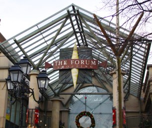
Chester’s market charter was granted in 1159.  The markets were originally hosted on the streets and Rows, with the focus in Market Square, outside the current Forum entrance.

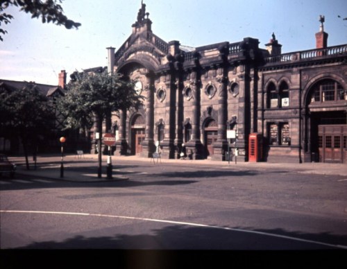
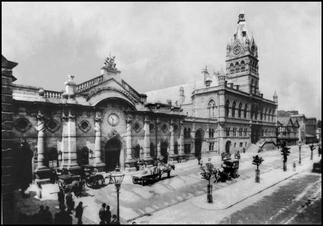
The first permanent building was the Exchange, built in the square in 1692 until it burned down in 1862. It was replaced by a grand Victorian construction in 1865, designed to complement the new Town Hall next door, although sadly this was demolished in 1967 and replaced by the current Forum building.

A second photograph below, from Wikipedia, but without attribution to an original source, is also excellent.  What it was replaced with was really bad, but even if it had been something halfway acceptable, the loss of this façade was tragic, a lapse of judgement and a thorough abdication of cultural responsibility.  Heritage was simply swept aside, and for what?  One wonders what went on behind closed doors.

The 1865 marketplace façade, next to the town hall, torn down in 1967. Absolute tragedy. Source: Chester ShoutWiki

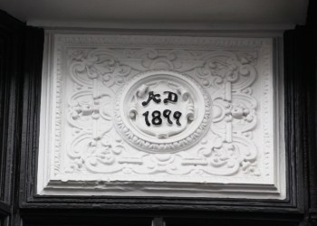
Quite by coincidence, a few weeks ago I took this photograph as I was attending the Local List  Workshop, and was on the lookout for anything slightly unusual or amusing.  This turned out to be the tragic sole remainder of that wonderful façade.

I am just hoping that the 2022 version of the market and town hall square heads us in the right direction.  Here’s their stated ambition:

“The vision driving the new market is to be a ‘modern traditional market’ that takes the best of the new breed of thriving city produce markets such as Borough Market in London, Barcelona market, combined with communal foodhall markets such as Altrincham and Liverpool’s Baltic.”

The entrance to the market as it looks at the moment

It’s a laudable ambition, but we will just have to see how it looks and feels when it comes to using itThe website states:  “Applications have now closed to trade at the new Chester Market. We expect to announce which traders have been successful over the summer.”  When the market moves, I sincerely hope that Mr Fernyhough the butcher, from where I buy game, is going with them.  I’ll ask him when I see him.

I am all in favour of a programme change for the more demoralized corners of Chester, including removal of some of the ugliest  previous attempts to revive it.  In this particular convergence of some great buildings, (Chester Cathedral, the Motor Works, the Town Hall and even the Story House) the space between them should be a vibrant and attractive place for people to enjoy, a  Cestrian piazza, so the hope is all there.  I am balancing optimism against past experience, but crossing fingers that the change will be substantially better, and will deliver something that everyone can feel good about.  

Architect’s impression of what the new marketplace will look like.  Source:  Chester Market website

The redevelopment of Chester Northgate: the imminent future

Architect’s view of two aspects of the new arcade, with the motor works at top.  Source: https://chesternorthgate.com

A couple of days ago I was trying to find out what the construction works were all about at the delightful Westminster Coach and Motor Car Works building next to the Town Hall on Northgate, its façade formerly fronting the library.  I found a whole website dedicated to the redevelopment of Northgate at https://chesternorthgate.com.

Too late to have any influence on the outcome, because the public consultation is over, but for those wondering what the redevelopment is going to look like, there are indications on the above site, including many more details and architects’ illustrations of what’s being planned.

It’s a matter of waiting and seeing what it looks like when it’s up, although one or two of the proposed new buildings seem completely out of keeping with Chester’s personality.  The new multi-storey car park, in particular, looks like a step in quite the wrong direction.

Architect’s view of the new car park. Source: https://chesternorthgate.com

The FAQs are well worth a look.  There’s also a history section with some interesting details about past developments intended to improve the marketplace itself.

Although there is always the worry that new shopping centres and arcades will concentrate shopping activities in new locations at the expense of older ones, I do hope that it brings renewed life to Chester.  The number of shop-fronts boarded up or simply abandoned in Chester is sad, including the former Browns/Debenhams, Patisserie Valerie, Edinburgh Woollen Mill and the entire of the Grade II listed St Werburgh’s Row.

Architect’s view of the new market place at the rear of the Town Hall.  The view below shows it as it is at the moment.  Source: https://chesternorthgate.com

A Chester Local List Workshop – what is local listing all about?

A few weeks ago, Chester Archaeological Society forwarded a request from Cheshire West and Chester (CWAC) for participants to attend a Local List Workshop.  I volunteered, but at that time I had only the fuzziest idea of what a local list actually is.  This post aims to clarify the subject of local lists and provides an account what happened during the fascinating Chester workshop.

A lot of county and city councils have programmes dedicated to local listing, and are running their own workshops and other forms of interaction with the public in order to launch their own local lists.  So what is a local list when it emerges from its burrow?

What Local Listing is not

The Grade 1 nationally-listed Chester Cathedral. Shame about the big purple sign, which completely destroys the first impression.  One of the lessons of Chester is that inappropriate signage and shop frontages can intrude very negatively on an otherwise beautiful city.

First, it’s useful to understand what local listing is not.  Local listing is not the same as the more familiar sense of the term listing, which is where a building or monument is “graded.”  Most of us are aware that when a building is officially listed and allocated a grade (Grade 1, grade 2 etc), it is given a special status and there are limits on what can be done to it and how it can be used.  Here’s part of the English Heritage explanation:  “Listing marks and celebrates a building’s special architectural and historic interest, and also brings it under the consideration of the planning system, so that it can be protected for future generations.  The older a building is, and the fewer the surviving examples of its kind, the more likely it is to be listed.”  There are currently 511 listed buildings (Grade 1, Grade 2* and Grade 2) in Chester City Ward alone.  Chester Cathedral, for example, is Grade 1 listed.  This is a national designation, and usually referred to as National Listing.

Local Listing

Local listing is different.  For a start, it is not a national designation and is not determined by a centralized national unit.  It is organized on a local basis by the council.  Here are some of the details on the Cheshire Local List Project website:

“In addition to the National designations, (including Listed Buildings, Scheduled Monuments, Registered Parks and Gardens and Registered Battlefields) local heritage can also be identified through the production of Local Heritage Lists of non-designated heritage assets. These enable the significance of any building or site on the list to be better taken into account in planning applications affecting the building or site or its setting.”

As I discovered when contesting a planning application in London a couple of years ago, one of the sticking points in objecting to any planning application is the concept of a “material consideration.”  A material consideration is something that a planning department takes into consideration when accepting or rejecting a planning application.  More to the point, anything that is not a material consideration is ignored when objections are made.  Local listing ensures that even those aspects of the built environment that are not nationally listed and have no grading are included as a matter of material consideration, which may make all the difference to communities attempting to care for their assets.

National, graded listing is designed to protect buildings and other sites, and ensures that when changes are proposed, a process of consultation takes place, but there are many other buildings, sites and objects that are not nationally listed, but nevertheless have an important role in communities, either because they contribute to community identity, or represent significant markers of local history.   As locally listed entities, these become subject to material consideration in the planning process.

The Cheshire Local List Project (CLLP) website goes on:

The Cheshire Local List gives importance to local heritage within the planning system, but also allows the expression of community identity, both through the list itself and through engagement in the research and designation process. It is a key component of conservation area management and Neighbourhood Plan development, and allows numerous stakeholders to better understand and appreciate the heritage of the county and its communities.

It would have been helpful if the word “listing” had been confined to national graded listing (such as when we refer to something as Grade 1-listed)  to avoid any confusion, but hey-ho, we’re stuck with it, and whatever it is called it is a really good idea, assuming that it is well implemented and becomes an integrated part of local planning procedures.  Local listing is a government initiative that sits at a level beneath graded listing, and is a much less formal designation, but could be just as important for communities if they work with councils to identify important local sites that cannot be nationally listed.  It puts the onus on councils to engage with the idea, but my hour on Google suggests that many have taken up the gauntlet.

The idea of the workshop

One of the Project’s aims is to be community-lead.  Here’s the official wording:  “We see the Cheshire Local List as a community-driven dataset. Rather than impose detailed criteria, which may be restrictive and exclusive, we have developed non-asset-specific criteria which we hope will enable local communities to define local heritage significance on their own terms.”

The term “community-driven” is often an indication that an organization intends to do nothing at all unless poked firmly in the ribs by some community-based pressure group, but here we had excellent James Dixon, Built Environment Officer (Conservation and Design) at CWAC, reaching out to Chester Archaeology Society, amongst other groups, for people to come and participate in a series of workshops.  The objective, ongoing, is to understand sensory experiences of small groups of people walking the same route through Chester to see how this might help to build an idea of what the concept of local listing might contribute to a city that already has 511 nationally designated listed buildings.   Rather than looking at the merit of individual buildings, this approach sought to develop an idea of how people respond to and interact with the city as a whole.

The approach is evidence-based.  Evidence-based approaches have become popular in all sorts of research that involves human interaction, including archaeology, social science and economic development as well as urban planning.  They have largely emerged from the basic idea of phenomenology – the way in which different living spaces are experienced and interpreted by individuals and communities – but are now a tool for developing  strategies or policies.  It takes the idea that how people live their lives and how they perceive their built, natural and cultural environment should influence what decisions should be made about those environments.  First, of course, is the requirement to understand people’s responses, both conscious and subconscious to the context under discussion, in this case the city of Chester.  In our workshop group at least, it produced some interesting results.

Another concept that has been incorporated into the Cheshire approach is “group value.”  This divorces heritage in its own right from other things we appreciate, such as assets, objects and spaces and how we experience all of these in a sensory way.  Valuable buildings are easy to put a finger on, describe and evaluate, but the open spaces in front of them, the odds and ends of  modern sculpture, ancient architectural lumps and bumps, and the occasional well-positioned tree or cobbled footpath are more difficult to evaluate.  And yet, they too are part of the heritage landscape, the built environment, the cultural context or whatever else we are calling it this year.  My above whinge about the purple sign in front of Chester Cathedral is just as important to people’s perception of how we move through our cultural space as the building we want to engage with, because signage is an attention grabber, and it manages expectations.

Archaeologists and historians are always flipping between what a site, building or object might have meant in the past and what it means in the present and how that distinction influences how we interpret the past.  That’s the archaeologist in me talking, but it works for any entity that we look back on from the perspective of time.  Cities and towns are accumulations, so we are reacting not to a single slice of time, but to an amalgamation that spans the oldest to the newest building and and is generally  experienced by the user (shopper, visitor, worker) as something that instead of having many multi-layered and multi-temporal identities, has one single identity in their own minds, in this case the identity of being Chester.

Because we humans are all so different from one another, a Chester identity is no single thing, because different people will respond to it in different ways depending on, for example, nationality, familiarity, personal interests, and the way in which they are intending to interact with it.  So Chester actually has multiple identities, each person perceiving the city as single cohesive entity but each doing so from a different perspective,  meaning that there are multiple identities of Chester, all of them compressing the complexities built up by time into a hurried present-day reality through which we pass, often in a tearing hurry.

In order to move beyond this sense of Chester being any single thing, James has come up with a method of directing participants in the workshop to look at Chester in an alternative way, something that had nothing to do with arranging its buildings chronologically or by function, but by asking us to think about how we reacted to different sensory aspects of it.

Participating in the workshop

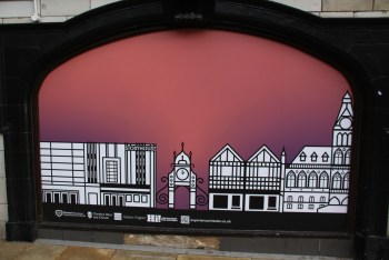
Post-Covid there are a lot of empty shops, looking abandoned and derelict, dragging down the image of their neighbouring shops. The entire of the St Werburgh Row is devoid of life, and tragic. This initiative, however, where empty shop windows are provided with imaginative Chester-themed boards is excellent, raising a smile. The one here is the former Patisserie Valerie on Bridge Street.

On the 18th of November, the 90 minute workshop started at the bottom of Bridge Street, where we received our instructions from James, an excellent, reassuring communicator who turns out to have a natural gift for herding cats.  From the bottom of Bridge Street to The Cross, and then from The Cross to the top of Northgate Street, the workshop set out to build an evidence base of sensory experiences including, for example, colour, sound, smell and texture, and more elusive concepts like fun and solitude.

James handed each of us a 6x4inch card, at the top of which was written a single word.  There were eight of us in the group, which was a good number for exploring some of the concepts, and enabled us to exchange notes on three occasions, once after we had walked Bridge Street, once after Northgate Street, and once in the town square, outside the town hall.  The topics were, in no order, were texture, colours, sound, stillness, views, words, and mine was fun.

There were Covid-aware latex gloves for those of us who wanted to explore texture by touch.  We could partner up with someone else, we could proceed en masse, or we could go off individually.  Apart from that we were given no direction so that the thoughts that came to us were not influenced in any way by James, or by the council’s objectives.

The idea was to write down words that occurred to us in relation to the given topic on the card.  I have to say my heart sank because I had no idea how I was supposed to interpret “fun,” but it was hugely enjoyable once I got into the swing of it.  The photos on this post are snaps that I took as I was walking around and thinking about my target word.  It came in very handy for consolidating my thinking as I went along.  If I had had a different word on my card, the photos would have been entirely different, which is an interesting thought in its own right.  For example, if I had had “stillness” or “texture,” both my words and photos would of course have been quite different.

The record cards

The keywords are clever, because they avoid simple reductionist descriptions based on liking or disliking, positives and negatives and instead focus on more nuanced responses and descriptions.

When he set us off on our own, James said that there was no right or wrong thing to write down, that the whole point was to let us react and write accordingly.  We had a card for Bridge Street and either the reverse side or a new card for Northgate Street.  One of mine is shown here, annotated to make it legible.  As well as capturing our thoughts so that we didn’t have to remember them, they helped us to marshal our thoughts when we gathered to discuss our findings.  We handed the record cards in at the end, so that James could collate them with those of other workshops.  The cards were an important part of the workshop.  Several of us had to apologize for our handwriting 🙂

Discussing the keywords

James was great at getting us together, on four separate occasions.  Two of the discussions were about what we had written on our record cards.  Here’s just a bit of  that, but I am sure that James received radically different comments when running different workshop groups, so this is just a sample of a sample.

In all the discussions it was clear is that we were all looking in different directions, and that’s partly because of the keywords, which directed attention to different parts of the built environment, and partly because of how we interpreted those keywords and what took our interest.

The Cross

Our first stop to exchange notes was at The Cross, where Bridge Street meets with the other three primary roads preserved from the legionary fortress, Eastgate Street, Watergate Street and Northgate Street.  We had at that stage walked only up Bridge Street.  James asked us what struck as what we found surprising about Bridge Street, within the parameters of the keywords on our cards.   I didn’t know anyone’s names, so these comments are all anonymous, and are shorter, simplified versions of what was discussed:

The Rows. There is a lot more stillness here than down on the streets, at least at the moment.  It makes for a nicer experience, but I am sure that the shops would prefer greater footfall.

Views:  As one looks up towards the Cross, the impression is of a great complexity pattern of walls and facades of buildings that forms an incredibly intricate pattern that frames the view from the floor up.  Some bits stick out, some don’t, and all the buildings have their own character, but they lead unambiguously to The Cross, along a road that is surprisingly wide given its Medieval past.  The rows give the whole thing a very distinctive feel, and means that the shops on those level are set back from the road. Everything converges on St Peter’s church, which is a big red sandstone building that draws the eye.  The path from one end to the other, seen as a view, is almost too much for the eye to make sense of.

Touches of colour in the old buildings above shop level stand out and are welcome.

Colours:  The biggest surprise was the contrast between the more or less uniform character of the builds above the shop frontages versus the brightly multi-coloured shop frontages themselves.  There were only a few details in colour on the older half-timbered buildings, which made the colour stand out.  Chester at street level is a torrent of colour, but when one captures a little of it in the buildings that soar above the shops, it is a lovely piece of deliciousness.

Sound:  In this area, the biggest surprise was what could not be heard.  There was such a cacophony of clinks, roadworks and street music, that the things that one could see going on around one, were lost in the other noise.  A pair of hard heels could be heard, but trainers and other soft-soled shoes were lost in the overall sound.  Even individual voices were difficult to make out.

Words:  At shop level the impact of words, in the form of text, was impossible to avoid, and overwhelming.  Branding and signage dominate, in a variety of lights and colours, and it is difficult to differentiate one from another.  Silent, in terms of audibility, they still manage to form a cacophony.

Different ideologies expressed in different building materials, different approaches, different design ideas,  different colours and textures.

Texture:  Texture occurs at every level.  It changes underfoot, but is most obvious in the walls, which are red sandstone, yellow sandstone, brick, wood, concrete and many other materials, which each has its own personality.  Decorative plasterwork is very distinctive and very fine, but not always noticed.  Each texture has its own character – granular, soft, smooth, slippery etc.  Each adds to the diversity of the buildings.

Stillness:  This one was rather sad in many ways at this point.  The main stillness was embedded in failed, closed-down shops.  There had been several before Covid, but there have been some tragic losses since.  These were all devoid of movement and interaction, dead areas that people walked past without looking.  More amusingly, anywhere not selling coffee had a certain stillness, by contrast to those places that were, which were busy, noisy and drew attention to themselves.

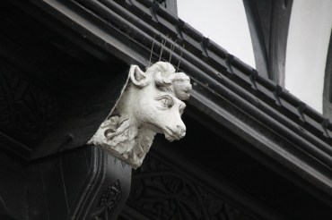
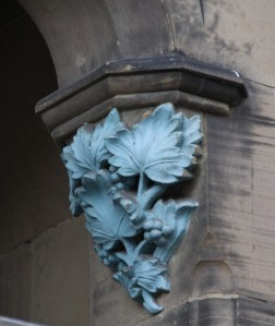
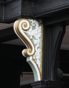
Fun:  There is not a lot of fun at foot level because it is all shops with unlovely frontages, but look up and there is a lot to make one smile in the decorative architectural elements that embellish the buildings, particularly the 19th century facades, a bit like excessively ornate wedding cake decoration, and improbable towers and incredibly ornate ironwork.  Often OTT, and very confident, these flourishes  are always very finely crafted.  They are both fine and truly great fun.

The Story House

The Story House is a thing of real ugliness, but even so I would defend it energetically if anyone were to threaten it because it is a monument to its era.  Not all heritage is pretty.  The same could be said for the telephone box in the foreground.  The bollards, however, at the edge of the road, were agreed by all to be cultural as well as physical barriers.

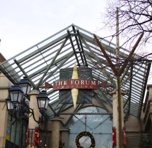
Our next stop was at the Story House.  Northgate Street had started out very like Bridge Street, with lots of engaging architecture similar to Bridge Street, again sitting on top of ordinary shop frontages, but as one proceeds, it opens out and there’s a lot of more architecture to see, some from more recent times, not all terribly positive.  The four most dominant buildings as one filters through the narrow entry to the market square are Chester Cathedral, the Town Hall, the Motor Works, and the Story House.  There is also a very conspicuous frontage to The Forum Shopping Centre, which incorporates the market.  At the moment, the Christmas market dominates the public space, closely clustered and overwhelmingly full of cooking smells.  We walked past the market and gathered in front of the Story House to discuss the walk up Northgate Street.

Inevitably and fascinatingly, we all talked about how interesting it was to compare the walk from the bottom of Bridge Street to The Cross with the walk from The Cross to the Story House.

Views:  This was a story of constriction within fairly narrow confines to a sense of release in the big space in front of the Market Square and the Town Hall, but it was also a story of disappointment.  The sense of being lead somewhere by views of trees beyond the narrow start of Northgate Street lead to nothing more than an untidy space that was undefined and offered nothing like the oasis that was suggested by the trees.  At this time of year, particularly, the trees lend very little because they are deciduous and have dropped all of their leaves untidily onto the ground.  The Christmas market did not improve matters.  The cathedral, to one side, was a pleasant presence but did not dominate.  The main dominating factor, in terms of being lead forward, was actually the Story House, not Chester’s most aesthetically pleasing building.  Beyond the Story House, the symmetry collapses and there is nothing to tempt one forward.

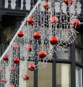
Colours:  This is so dependent, just as it was on Bridge Street, on where you happen to look.  Ground level is bright and full of aggressive colours, but although on Bridge Street these were very jarring, they are more restrained on Northgate Street.  Looking up things are far simpler with black and white facades, and reddish-brown brickwork that provide a warmer feel.  The Christmas decorations were felt, by everyone who expressed an opinion, to be just right, not overstated or understated, but entirely suitable for the job in hand.

Sound:  In contrast with Bridge Street, Northgate Street was a far richer audio experience.  There was tapping, humming, rattling, the sound of wheeled suitcases on cobbles, a bicycle, and more human traffic, as well as the inevitable street music.  The sound of heeled shoes versus trainers was again particularly noticeable.  Reaching the marketplace, the noise of people talking increased enormously, and there was more traffic.

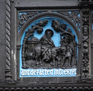
Words:  The plethora of promotional messages at street level was again dominant.  It was all very urban and vibrant, but there was also text in the historic buildings above the shops, where there were other messages to be seen that were resonant of the past.

Textures:  There were so many textures to be seen including the old versus the new, tiles versus glass, wood versus brickwork and the incorporation of carvings and sculptures into building facades.  As well as buildings, there were plants and trees to take into account, including moss on cobbles next to the cathedral.

Stillness:  The cathedral, a former abbey, is an oasis of stillness in the city, and offers a gateway into an inner peace, including its gardens.  The interface between the city and the peace beyond is provided by the Abbey Gate, and was probably the only entirely still place in the part of Chester that we walked on that day.

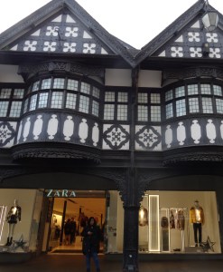
Fun:  Again there were a lot of excellent architectural details that were functionally unnecessary but expressed real exuberance.  Examples are the little sculptures in niches above the row of shops that includes Lakeland and Zara, little towers at the top of buildings and ornamental plasterwork on all sorts of buildings.  The overall impression of certain attention-grabbing buildings, like the town hall and the motor works lift the spirits, and both these draw attention to the positive impact of colour in building materials.

We did not, of course, explore internal spaces, but the idea of exploring interfaces between external spaces and internal spaces is an interesting one.  Little corridors leading from one space to another gave an almost secret feel to some of the city.

The good, the bad, and the highly nuanced

The other two discussions took place first in the public space in front of the Town Hall and the entrance to the market (The Forum Shopping Centre) and then at the point of Bridge Street where it becomes traffic-free and were less on what was on our cards than on our overall impressions.

Market / Town Hall Square

When we paused in front of the Town Hall, in what is usually an open area, we were asked what our impressions were of that public space.  The Christmas market was setting up, obscuring a sense of what it is like of most days of the week, but some interesting comments emerged.

Two of the dominant buildings, the Town Hall and the old Motor Works were exuberant, and were terrific examples of how whole buildings can express the enthusiasm and enjoyment (as well as ambition and pride) of those who created them.  They, together with the Story House and the Cathedral, surround the public open space.  The chap who was looking at “views” drew attention to how we had been funnelled from the lower end of Northgate Street, between buildings similar to those in Bridge Street into a space that, from a distance, with trees visible, had led to a sense of anticipation, but had very little to offer.  There were random odds and ends dotted around, leading to the sense that there was no cohesion in the space.  A very grubby Roman column here, a modern sculpture there, and an anti-terrorism barrier across the road.  I think that we all had the sense that nothing seemed properly integrated, and that a public space that might have had real potential was actually very drab, in spite of being surrounded by some great buildings, each of a very different but superb character.  We also looked at a bike rack that was very intrusive but could be placed somewhere less conspicuous and still be useful.  This was no piazza or plaza, and there was really nothing to celebrate.

The entrance to the indoor market.  A reminder of Chester’s Roman heritage, or just ugly?

I found myself almost back to back with a Roman soldier who was explaining something to a small group of visitors. I love the soldiers, who certainly come under the heading of “fun,” because wherever they go they raise a smile, but these soldiers, whether giving guided tours to adults or leading long strings of children wearing cardboard armour and carrying cardboard Legio XX shields, are a terrific innovation.  Some of us were also facing a Roman column that usually looks a little forlorn and isolated, and for which I have affection, but on that day looked more than a little farcical hemmed in on all sides by the Christmas market.   In Chester, a great effort has been made to incorporate the city’s Roman past, and there are constant, excellent reminders that help to reinforce the fact that as well as the built environment, the buried environment also plays an important role.  But that column could do with a rethink and a clean.

Little flourishes are worth looking out for.

Although the keywords on the record cards avoid simplistic likes and dislikes, positives and negatives, we found that in discussions value judgements were inevitable, because for every example of “fun” there is probably a “dull” in the next street, and for every ten tactile and aesthetically enjoyable examples of “texture” there is probably an edifice of brutal concrete nearby (the Pepper Street multi-storey car park springs to mind for both examples).  One of the interesting things from the discussions was that there are so many positives that the negatives stand out as noticeable intrusions on the positives.  One of the workshop members pointed out that anti-terrorist bollards, for example, are not only very ugly with their modern appearance and big lights, but give a misleading sense that there are better bits and less desirable bits of the city, separating  areas in which one is safe and where there are good thing to visit from those which may be not quite as safe, and not quite as worth visiting.  Once this was pointed out, everyone agreed, and we all understood that the city should not be seen in terms of what lies within and  what lies beyond those bollards, but that the perception is difficult to avoid.

Upstairs or downstairs – where does the fun lie?

Response to the keywords is a hugely personal thing.  I am guessing that many workshops would be required to capture even a small sample of what an entire community might think and feel about their living environment.  I interpreted “fun” as anything that would make me smile spontaneously.  I automatically looked away from the street level shopfronts to the upper levels where time, imagination and skill have wrought wonders. Some shop road level frontages are better than others, but for me all are brash, most of them frightfully ugly, and I hate shopping anyway, so nothing fun is to be found there.  But I have friends for whom shopping is hugely enjoyable, and the bright lights and colourful window dressings are all part of the enjoyment, and some of them would be puzzled by me describing architectural exuberance and decorative flourishes as “fun.”  So my interpretation of fun, confined to the upper levels where history looks down at me and I look back at it, would not be someone else’s.

Pausing again on Bridge Street

We paused again on Bridge Street, just on the uphill side of the anti-terrorist bollards, to discuss our views.  We were on borrowed time, as we had eaten up most of our 90 minutes, but we were all eager to point out the negatives of our immediate environment, because we all wanted to see improvement to encourage businesses to invest in that part of town.  Everyone agreed that the anti-terrorist bollards seemed, again, to cut one part of the street from another, and that the area north of Bridge Street was rather more prestigious than that to the south of them.  We also looked at some truly awful shop frontages, text-heavy, with lurid colours, tacky.  We asked about planning permission for frontages, as we were standing in front of a particular shocker at the time, and it turns out that they are indeed subject to planning permission, but that some retail outlets do not follow the procedures.  There is a lot of work to check up on those who ignore the rules, and it takes even longer to enforce the violated regulations.

The future

James said that he will feed back to Chester Archaeological Society about the results of the workshops once they have all been completed, and I really look forward to that.  Particularly, it will be interesting to know the answer to James’s own question – what can the local list do that designated graded listing does not already do in somewhere like Chester, which has listed buildings everywhere you turn?

The good news, even before the workshops have been completed and their findings collated, is that the Local List facility is already up and running and you can nominate an “asset” for local listing if you feel that it has particular community value and should be taken into account when planning and other issues are raised that might place it under threat.  You can find out full details on the Chester Local List Project website at the following address:
https://local-heritage-list.org.uk/cheshire/guidance:

The Proposal Process

When you make a proposal or proposals for the Cheshire Local List, you will first have the option of creating and revising a draft that will not be reviewed until you submit it. When you submit your proposal, a Conservation Officer will check it to see if more information is needed. If so, it will come back to you for revision, and if not it will be moved forward for approval.

Make a proposal for the Cheshire Local List here

Approvals for nominations to the Cheshire Local List will be done by a panel of Conservation, Planning and Built Environment officers from Halton, Cheshire West and Chester and Cheshire East.

The final list will be put forward for formal adoption by each of the three boroughs in due course as part of the development of new Supplementary Planning Documents for local heritage.

The Assessment Criteria are here:
https://local-heritage-list.org.uk/cheshire/assessment-criteria

The top-level asset categories are Buildings; Parks & Gardens; Landmarks, Art Works and Way Finders; Other Sites, Structures & Landscapes, but see the following page for more information on each category:
https://local-heritage-list.org.uk/cheshire/assessment-criteria-asset-type

If or when I hear more about the project, I’ll post about it on the blog.

Two more 1898 mileposts on the Chester-Worthenbury turnpike route located

Regular readers of the blog will know that I am on a minor quest to check up on all the 1898 milestones that were recorded in the 2018 Milestone Society survey and see what sort of condition they are in.  A full set should run from Chester to Worthenbury and I am slowly assembling a photographic record of the survivors, hoping that all are eventually located.  Last week I located two of the ones that were missing from Chester to Churton, respectively at Huntington and Crook of Dee.  I have updated the main post in which I talk about the 1898 milestones, including the What3Words address for each, but here are last week’s photos for those who have already read that post.

The first, at Huntington, was standing on a neatly mowed street-side road on the northern side of a pedestrian crossing, very easy to spot if a car is not parked in front of it.  It is in beautiful condition, and it was nice to be able to get a good look at the maker’s mark and the back of the milepost, which is usually very difficult to see clearly.

Huntington milepost

The second, opposite Cheavely Cottages at Crook of Dee to the north of Aldford, was completely hidden from view when I went looking for it in the summer, and it is only thanks to a recent trimming of the shrubby hedge and the autumn leaf-fall that I was able to see it.  Even then, it was covered in tendrils of ivy that I pulled gently away to take photographs, and the lettering at the base is fully embedded in fallen leaves and general build-up of earth and twigs.  I would have liked to do more for it, but it is an incredibly dangerous section of the road, on a blind bend with no pavement or verge, just a foot or so of raised ground on which to perch.

Cheaveley Hall Cottages milepost


The Roman villa at Rossett #3 – The Archaeology Open Day

Chris Matthews from Archaeological Survey West, explaining the puzzle of Trench 2. Note the dark areas of the trench, which contain remains of charcoal and are evidence of burning.

The Archaeology Open Day on Saturday 18th September was a super idea.  There has been so much interest locally about the recent Roman discoveries that it was always going to be a great success.   We were there at 1300 for the 1330 talk on a nice dry day, and the atmosphere was terrific.  The event, which was free but had to be booked in advance, was sold out.  It’s not often that a very local archaeological site becomes an A-list celebrity, but this has the badge, mainly because of the excellent work done to keep the public informed via Archaeology Chester and the #RomanRossett posts (or “tweets” if you really must) on Twitter.

I had already done a lot of reading to find out more about the rural hinterland of the legionary fort at Chester.  My first posts about the villa, part 1 (a summary of research about the nature of villas in general) and part 2 (about the background to the discovery of the Rossett villa, derived from the project team’s posts and tweets) provide some background about the excavation.   All that reading and typing was a nice prelude to the day, but seeing it in the ground, being exposed by trowel and brush as we watched, brought it all superbly to life.

There’s not a lot of point to this photograph, except that I really, really fancy that vehicle on the left, which I could really see myself driving.

Everything was so beautifully arranged on the day.  I picked up my Dad from his house in Rossett and we drove through Burton towards the site, which had been given a What Three Words location (the best way of providing a location for absolutely anything).  Initially the location of the site was very wisely kept secret, to protect it against night-hawking (illegal treasure hunting).  It is lovely that the decision was made to make the location public, so that visitors could see the excavation on an Open Day and learn more about the site.

As soon as we approached the site there were little signposts helping to direct visitors to the site, and there was a one-way system set up to let people into and out of the field next to the site, efficiently managed by some great volunteers who managed to be efficient, relaxed and humorous, which must take some doing when directing the chaotic general public into a field that was to serve as a carpark 🙂  Given clear direction by the volunteers, cars lined up beautifully without blocking anyone else in, and the mood as we all headed towards the excavation was one of gentle excitement.

Our names were checked at the gate between the parking field into the excavation field (perhaps a liminal zone 🙂 ), and we were handed an information sheet, English on one side and Welsh on the other.  Tables were set up in front of the excavation, one with some of the finds that had been excavated in the previous two weeks, another set up to explain the super Portable Antiquities Scheme, another with a set of things-to-do for children (questionnaires, word games and trails).  There were lots of leaflets to collect, and there was even a coffee trailer, which was doing very good business.  In short, lots to keep early arrivals for the talk happily busy.

The Portable Antiquities Scheme, it should be mentioned, is one of British archaeology’s greatest inventions, and there is a Welsh branch, PAS Cymru.  The idea was to set up a service for registering anything that the general public found that might be of archaeological interest, and is helping gardeners, walkers and metal detectorists to not only have objects identified, but to contribute those finds to a national database of objects that has become a massive resource for researchers from prehistory to the 17th Century.  That’s quite an achievement.

The first thing that attracted the eyes (and ears) as we moved towards the trenches was a big tarpaulin covered in children with archaeological sieves, who were all having a fabulous time.  What a brilliant idea!  “Artefacts” had been hidden in heaps of earth and the children had to sieve through the heaps to find them.  Looking at the sheer joy with which children, helped by  grinning parents, were sifting through the soil to find the objects, I suspected that an awful lot of tiny would-be vets, football stars and celebrity chefs decided there and then to become archaeologists instead.

Trench 3, the villa

We were free to wander around the site until the talk began.  The site had been opened at 1000 for wanderers, and then site tours arranged for 1100, 1230, 1330, and 1500 with Roman re-enactments at 1145 and 1415.  That’s a lot of public interaction for one day!  I believe that Stephen Grenter, Heritage Services Manager, at Wrexham Museum and our tour guide for the hour, said that there were going to be over 200 people turning up over the course of the day.

The first striking thing about the site, apart from the uncovered foundations, was how near the surface those foundations are, just a few inches down, probably less than a foot.  There were four trenches open, three at the villa itself and the fourth some distance away that is being excavated by local school children, a superb incentive.  There are plans to involve more school children from surrounding areas as the dig progresses in the future.

Trench 3, the villa

The excavation was just heading into its final week of a 21-day run, an intensive three-week opportunity to find out what’s down there.  That was a fascinating experience – all the interest of seeing what had already emerged, and a sense of the next chapter of the book missing because there was still a week to go.  Thank goodness for the project’s updates on Twitter to keep the momentum going.

The field in which the villa is located has ploughed for at least five years, which has the potential downside of disturbing upper levels, but has the upside of turning up all sorts of interesting finds that suggest the presence of something more substantial below.  It is often disturbance of this sort that suggests to archaeologists that survey, potentially followed by excavation, may be worth organizing.

I’ve talked about the background to the excavation in my previous post about the site, but Saturday was the first opportunity I had to see the site in all its glory.  It is years since I’ve done any Roman excavation but it made me want to whip out my trowel and leap in.  Super to see it all happening.

Trench 3, the villa

Trench 3 has been opened to explore the footprint of the former villa, approximately half of which has now been exposed.  It was great to see how the magnetometry survey image was being translated into real life stone foundations and floors.  Samien pottery, black-burnished ware (imported from France and Dorset respectively) had been found, as well as mortaria, a Roman coin from the date of Constantine (327-341AD), a bronze pin, animal bone and various other finds.

Trench 2, just a few feet away from the villa, and shown at the top of the post with Chris Matthews giving an impromptu talk on the subject, was an enigma at the end of week two, but two pieces of medieval pottery had been discovered.  By the end of the week, Chris Matthews reported on Twitter that it had been established that these were the remains of a medieval building with some fairly heft walls that had been robbed in the past, leaving just the foundations.  The walls retain some pieces of facing stone, which means that something of its external appearance survives.  Traces of carbonization were already visible, often a sign that a fire has contributed to at least one phase of a building’s history, and 14th Century pottery was beginning to emerge.

Trench 1, the possible bathhouse, showing a massive external wall

Trench 1 is a little farther away and lies close to a brook that circles part of the field within which the villa lies.  The proximity of the building both to a water source and to the villa would be ideal for a bathhouse, and excavations were well underway, but this has yet to be confirmed.  Some of the exterior walls were vast, the one above nearest to the camera about 1.2m thick.  A little piece of painted plaster had been found in the morning of the Open Day, so it is possible that the possible bathhouse’s internal walls were once decorated.

The project is  a good example of different interest groups, including academic, museum and commercial interests working together with amateurs, metal detectorists, and volunteer diggers to reveal the area’s past.  The dig was funded by a number of benefactors, which tells its own story of how many parties it takes to get something like this off the ground.  Hats off to all of them.

A seriously great time was had by all.  I suspect (or more precisely hope) that not only will the project receive more funding for the planned six week project next year, but that this dig will be just the beginning of a much bigger project to understand the Romano-British and prehistoric past in the Rossett-Burton area, and the poorly understood areas beyond.

Sources of information for this post were Stephen Grenter’s 1330 talk at the site, the #RomanRossett Twitter feed, and the University of Chester’s excellent video on the subject by Howard Williams and Caroline Pudney at https://www.youtube.com/watch?v=SVXrb45pCiw

For those wanting to read the previous news about the Rossett villa excavation, its aftermath and future plans, use the hashtag #RomanRossett on Twitter to keep yourself updated

You may also be interested in my two posts about the Roman Road
that once ran east of Churton and Holt


The Roman Villa at Rossett #2 – Some background to the excavation

It is difficult to imagine this field as a beating heart of a villa complex life in northeast Wales, but here it is.

This short series focusing on the Rossett Roman Villa began yesterday with Part 1  – What is a Roman Villa? , which was an overview of Roman villas in general, looking at how they are defined, their key features, what is known about who lived in them, how they changed over time and how they are dated.

Today’s post, part 2, looks at the background to the decision to start excavating at the site, information assembled from press releases, the villa project’s Twitter releases (impressive!) and the information imparted by Stephen Grenter, Heritage Services Manager at the Wrexham Museum on the Open Day.  Part 3 describes the excellent Archaeological Open Day that took us through what was happening in the three big trenches opened in the last two weeks, as well as plans for the future.  Again, I just want to say huge thank-you for such a great tour of the site and the sheer amount of knowledge imparted in such a relaxed but professional way.  I have included some of the information communicated on the day in this post, and much of the rest is taken from Caroline Pudney’s posts on Archaeology Chester, with thanks to both of them for being so generous with the information, but of course any errors are my own.

The Rossett villa before excavation.  Source: Archaeology Chester

The strategically important legionary fortress at Chester means that a Roman presence in the surrounding area was almost inevitable, and it has been known for a long time that there was a civilian settlement south of Chester at Heronbridge, Roman industrial activity in Holt (a brickworks and tileworks) to the east and at Halkyn Mountain to the west.  Also in the west, Ffrith has produced Roman remains, but it lies under the village so not much is known about it.  Up until now, however, nothing concrete was known about Roman activity in the Rossett-Burton area.

The Rossett site is located to the west of Burton and is the first villa known from northeast Wales, making it of particular importance.  Prior to any major discoveries, the existence of a Roman presence of some description in the area had already been inferred by archaeologists who had found Roman objects in local ploughed fields.  Ploughed fields are excellent for field walking, as the action of ploughing draws artefacts from lower down up to the surface of the field, and they are often clearly visible against the dark soil.  When the field is recently ploughed, there are no distractions like crop stubble or weeds.

A site plan taken from the geophysical survey of Rossett villa. Source: Archaeology Chester

Confirmation that from the 1st Century onwards Romans had at least passed through the Rossett-Burton area came with a discovery made by a responsible metal detectorist who reported an important find:  an inscribed lead pig that turned out to date to the 1st century AD, the century in which the Romans first arrived.   All of a sudden, the Burton area was in the archaeological spotlight.  A survey and excavation of the ingot site followed, funded partly with a grant from the Roman Research Trust and carried out by archaeologists from Wrexham Museum, the University of Chester and Archaeological Survey West.  There was sufficient time and funding remaining after the ingot investigations had been completed for further geophysical survey work to be carried out in a nearby field and this revealed a beautifully delineated buried structure with the typical layout of a Roman villa, staggeringly clear on the survey image shown below.  Additional structures were evident, but not so easy to interpret, and some of those too are now under excavation.


Background

The Rossett Ingot

The first indication of a site near Rossett was the discovery of a lead ingot or pig.  A pig is a roughly rectangular bar of mined metal that is shaped to be convenient for transportation to a location where it can be processed.  Its discovery by detectorist Rob Jones, who reported the find to the archaeological authorities, was reported on the Archaeology Chester (University of Chester) blog:

Lead pig in situ. Portable Antiquities Service ID WREX-8D3982. Source: Archaeology Chester.

Our story begins in September 2019 when a lead pig (ingot) marked with the name of Trebellius Maximus, the Governor of Roman Britain from AD 63 to 69 was found near Rossett, Wrexham County Borough, Wales. A responsible, skilled, and knowledgeable local metal detectorist found an impressive metal signature while out detecting. He immediately contacted the local Finds Liaison Officer based at Wrexham Museum and the object was subsequently excavated with the help of staff at Wrexham Museum and the Clwyd-Powys Archaeological Trust.

The find generated a lot of interest in academic circles and was widely reported in the media, because this is the first inscription known in Britain that mentions Marcus Trebellius Maximus, who was the governor of the province of Britannia between AD 63 and 69 during the reign of the Emperor Nero, one of Britain’s first governors after the AD 43 invasion.   An administrator rather than a soldier, he made no push to gain more territory, placing emphasis on consolidation and economic growth.  He was unable to secure the respect of the military and in AD 69, after the death of Nero and a period of instability in Rome, a mutiny in Britain forced him to flee.  He was replaced by Marcus Vettius Bolanus who had the twin assets of being both a Roman Senator and a soldier.

One of Julian Baum’s stunning impressions of Deva, showing the
beginning of Watling Street West (Margary 6a) and the Dee
crossing linking to roads south and west. Source: Julian Baum, Take27 Ltd.

Although as a legionary fortress Chester was an important Roman centre, with roads radiating out of it towards other Roman sites in all directions,  northeast Wales itself has not provided much data to support the idea of a significant Roman interest in the area, so the find raised two important questions that led to the decision to carry out further surveys and excavations in the area.  The first question raised by the pig itself was about the extent to which the Romans were exploiting local mineral resources from early on during their occupation of Britain.  The second concerned how a major new Roman find might shed light on the Roman occupation of northeast Wales, data for which is extremely thin on the ground to the northwest of Wrexham and southwest of Chester.

Not the most ideal conditions for excavating the ingot site!  Source: Archaeology Chester

The initial fieldwork, phase 1 of the project, took part during partial lockdown with atrocious weather conditions during September and October 2020, with financial support from the Roman Research Trust, the University of Chester and Wrexham Museum.   Although the surveys suggested some promising features, excavation by a small 6-person team, battling with rapidly flooding trenches only revealed remains from mainly much later periods.  The absence of Roman period finds during the excavations was, however, informative:

The absence of Roman archaeology and confirmation of alluvial deposits highlighted the likely watery or marsh-like setting that existed during the Roman and later periods. In turn this tells us that the ingot is reflective (perhaps) of a stray loss since no evidence of deliberate deposition or lead processing could be found nearby. [Pudnesy 2021]

The conclusion is that the lead was mined elsewhere and was lost in transit on its way to its intended destination.  The analysis of the lead at Liverpool University, which hopes to narrow down a source, is still ongoing but initial work suggests that it may have been mined from elsewhere in northeast Wales, perhaps at somewhere like Ffrith, where Roman remains have been found, including indications of lead mining, or Minera:

That the Romans mined lead at Minera has long been inferred; the mineral veins would have been easily discovered at outcrop, a Roman road passes close by, and residues of lead smelting have been recorded in a Roman context only three miles distant. Proof
remains elusive though ancient working is inferred by the discovery of a stone mortar. [Peter Appleton]

No further archaeological remains were discovered at the site during excavation.

Lead ingot from a river jetty site at the edge of Chester racecourse dating to 74AD.  Source:  David Mason’s book Roman Chester, p.45.

Other pigs have been found in the Chester area.  David Mason shows one in his book Roman Chester, excavated with the remains of a timber jetty at the Roodee (Chester racecourse on the side of the river Dee) in 1886 dating to AD74.  The text is abbreviated but reads “[Cast] while the Emperor Vespasian Augustus was consul for the fifth time and Titus, acclaimed Imperator, consul for the third time.  On the side is another inscription that reads “Deceangl” meaning that it was mined on Deceangli territory.  The Decaengli territory of northeast Wales ran along the borders of the Cornovii territory that occupied what is now West Cheshire, and probably extended up the Wirral.

Wales in AD47. To the east of the Deceangli, in what is now Cheshire, was the tribal area of the Cornovii, who were based at Wroxeter.  Source: Emerson Kent

Britain’s mineral resources were amongs the properties of Britain that was extremely attractive to Rome, and the territory of the Deceangli had numerous stone and metal resources including lead. Lead was used in building projects, but some of it was also a source of silver when subjected to a process called cupellation.  Lead mines at Prestatyn were established in c.75AD.  Others have been found at Meliden, Pentre-Oakenholt, Halkyn and Ffrith. Clwyd and Powys Archaeological Trust describes an ore vein that runs east to west at Halkyn.   A Roman ‘pig’ or ingot of lead was found in 1950 inscribed with the letters C NIPI ASCANI, the abbreviated name of a private lead producer, C. Nipius Ascanius, the lead thought to have been mined and smelted on Halkyn Mountain.  Excavations in the Pentre Oakenholt area of Flint have provided evidence of lead smelting, presumably from ores from Halkyn Mountain. Roman domestic buildings at Pentre Farm, Flint may have been the home of a mine supervisor.

Magnetometry results at Rossett Villa. Source: Archaeology Chester

There was sufficient funding from the Roman Research Trust grant left over for additional geophysical survey.  Stephen Grenter had visited the field in which the villa was found at an earlier date because pottery sherds and other small finds had been made there, and found additional objects that suggested that it would be worth carrying out additional fieldwalking and geophysical survey, so this was carried out.

The field walking recovered a total of 181 artefacts from the ploughsoil. A large proportion of artefacts were ceramic, including brick and tile (CBM).  A total of 76 sherds of pottery, 23 fragments of worked stone, 4 metal objects, 5 fragments of glass and one fragment of animal bone were also retrieved. Together with fragments of painted plaster and opus signinum, the assemblage reflected the likely presence of a Roman building, but potentially of higher status than we’d initially suspected. [Pudney 2021]

Geophysical survey (magnetometry) followed.  Geophysical survey results can be remarkably difficult to interpret, but the amazing scan of the villa’s foundations, was phenomenally clear, showing the perfect layout of a wing and corridor villa with rooms behind.  Other features suggested by the geophysical survey were not nearly as clear, and some of those are now under excavation.

The Rossett Villa

To the west of Burton Green, the villa is described as  Rossett Villa.  Clear evidence of Roman occupation in the immediate area had been indicated by objects produced in the process of agricultural ploughing as well as metal detecting.  These items included pieces of samian ware (terra sigillata, a Roman luxury ceramic), box tiles,  fragments of mortaria (food preparation mortars) and quern stones.   Other Roman objects  found in the general vicinity had been registered with the Portable Antiquities Scheme including Roman brooches and coins.  The presence of a villa had not been suspected as they are extremely rare in the northeast Wales/Cheshire areas.

Primary areas of villa occupation in Roman Britain. Source: Rowe, J.E. 2015.  Roman Villas of Wales.  M.A. Thesis, University of Regina, Saskatchewan

The Rossett villa is unusual in that its location is outside the main distribution area of villa sites.  The densest concentration of known villas is in the south of England.   Rossett is only one of two villas known in the area that potentially fell under the influence of the Chester legionary fortress, the other being located at Eaton-by Tarporley.  The discovery of signs of a hypocaust at Crewe-by-Farndon have led to suggestions that there may have been another a third one in that area (mentioned in the the Farndon Archaeological Assessment).  The nearest villa in Wales is at a substantial distance from Rossett, in a remote part of Ceredigion, near to Trawsgoed Roman Fort.

Some of the sites in the Chester area are connected to one another by the Roman road network, but it is not yet fully understood how northeast Wales was reached from Chester and how it was connected to west Wales, including the sites at Ffrith and Halkyn.

The wing and corridor villas at Sparsholt (top) and Lullingstone. These artists’ impressions are intended to provide an idea of what a villa might have looked like above the level of the foundations.  Source of Sparsholt image: Johnston, D.J. 1991 (cover photo).  Source of Lullingstone image:  English Heritage Lullingstone website)

The Rossett villa is located just off the proposed route of a potential Roman road from Chester. It has been suggested that the road may have run south from the fortress, across the bridge shown in Baum’s reconstruction of Chester above, before turning southwest and passing through Ffrith, where there is plenty of evidence both for Roman settlement remains and a stretch of Roman road, before proceeding via Bala to the fortlet at Brithdir to the south of Dolgellau.  This presumably also connected with the Cefn Caer fortlet at Pennal (about which I posted on another blog here), which guarded a crossing over the river Dyfi, connecting north and south Wales.  It is hoped that future LiDAR research will clarify the location of the road.  It worked a treat with clarifying Roman road 6A (also known as Watling Street West) that runs south from Chester via Aldford and Malpas to Whitchurch and beyond to Wroxeter (about which I have posted here).

The nearest villa to Rossett, as the crow flies, was actually at Eaton by Tarporley in Cheshire, excavated 1980-81 and again in 1982.  As far as I know, it remains Cheshire’s only known Roman villa, as reported by Morris in 1982 and 1983, and summarized  on the Heritage Gateway website.  The summary is copied here because it provides a useful illustration of the often multi-period character of villas:

Excavations of Eaton-by-Tarporley Villa. Source: Morris 1982 and 1983

During the laying of the Lake Vyrnwy-Liverpool water main in 1886, Roman tiles, mortar and a coin of Marcus Aurelius were found on the western fringe of Eaton-by-Tarporley (a). A field-walking programme in 1980 to investigate the context of these finds, led to the discovery at SJ 57176341 of a Roman winged-corridor villa, the first villa to be identified in Cheshire. Excavations were conducted on the site from 1980-82. These revealed 4 Roman phases.
Phase 1. Only two post-holes were found relating to the primary occupation of the site, perhaps beginning c. AD 150. The building was probably short-lived, quickly succeeded by the phase 2 construction on a different alignment.
Phase 2. A timber building was erected delimited to W and N by ditches perhaps serving to convey water to the site from a nearby spring rather than for drainage. Again the building seems to have been short-lived, this time destroyed by fire.
Phase 3. About the last quarter of the 2nd century, the first stone-built villa was constructed, of winged-corridor plan and of a single storey only. The S wing formed a baths suite. All rooms in the main range were decorated with painted wall-plaster and had floors of opus signium or mortared pebbles. One room here was heated, plus two in the N wing.
Phase 4. c.AD 350 the villa underwent thorough reconstruction. The colonnade was demolished and the living space extended out to this line. Thickening of the walls indicates a second storey was added at this time. No evidence survived for the destruction/abandonment of the villa due to Medieval stone-robbing and PM ploughing.
Medieval. Large numbers of pottery wasters were recovered from the villa, and excavation SW of it located a complex of 14th century pottery kilns. At some later date but still within this period, a building of unknown function was erected out of re-used Roman materials over the SW corner of the villa.  

The villa included a bath suite including a calidarium and tepidarium sitting over hypocausts (raised floors on short pillars, the spaces created heated with fires), and a frigidarium for cooling off.

Two different ideas about the appearance of Abermagwr in Ceredigion, a small villa dating to c.AD 230, both views drawn by one of its excavators, Toby Driver.  This demonstrates that although foundations may look much the same from one villa to the next, the actual appearance may differ considerably.  The two interpretations also usefully suggests that the survival of inorganic building materials, particularly wood, may potentially offer an alternative interpretation. Sources: RCHAMW (top) and Wales Online (bottom)

In Wales itself, the only other villa site known north of south Wales is in Ceredigion, less than a mile from Trawsgoed Roman Fort, and in a very remote area.  Abermagwr villa was first identified from aerial photographs taken during the drought of 2006, was subjected to geophysical survey in 2009 and was partially excavated in 2010 by by Jeffrey Davies and Toby Driver.  Described by its excavators as “a comparatively modest late third- to early fourth-century AD house,” was established around 230AD, which is interestingly around a century after the Trawsgoed fort was abandoned, and it is suggested that building material from the fort’s bathhouse was used to build the villa.  It had a very fine slate roof, and finds included pieces of a remarkable glass bowl that was made in Germany’s Rhineland. The villa burned down in c.330AD, and was abandoned.

This is a very poor showing for villas in northeast, northwest and mid Wales, and for Cheshire as well.  The scarcity of villas in this area seems to require an explanation, particularly as Chester was such an important fort, there was a civil Roman settlement at Heronbridge just to the south of Chester near Ecclestone, a tile and pottery manufacturing base was located immediately to the north of Holt and there was another pottery production centre at Plas Coch on the outskirts of Wrexham.  This was an area of prime agricultural land that one would have thought would be ideal for the establishment of one or more potentially profitable estates.  There are two primary reasons why sites do not occur on distribution maps. The first is because they were simply not built in certain areas, and the second is that they have not yet been found.  There are more reasons too, such as sites that have been completely destroyed, or those that whose building materials were robbed for the building of other buildings, but a complete absence of evidence in an area tends to fall into one or other of the first two categories.  In practical terms, this means that a gap on a distribution map is a question mark, not a sign that nothing was build there.  This is perfectly demonstrated by the Eaton-by-Tarporley, Abermagwr and Rossett villas, all of which turned up in places that were empty patches on villa distribution maps.   With more grants for future research, a lot more field work and a bit of luck thrown in, the Rossett and Burton areas may reveal more previously unrecognized archaeology, including that from both previous and later periods. Indeed, Toby Driver has recorded cropmarks at Rossett similar to those at Roman villas in other parts of Wales (noted on the Coflein website).  However, with the discovery of the Rossett villa, it seems likely that others will now turn up.


Conclusions

Findspot at the Rossett Roman villa excavation.

Even before I went to the Open Day, the team had made it clear in their reports that the Rossett and Burton Green finds are exciting hints of a greater Roman presence to the southwest of Chester than had previously been suspected.  Both the original discoveries and the work that has since taken place will hopefully form a platform for the launch of future survey and excavation work that will help to clarify how northeast Wales fits into the bigger Roman and Romano-British picture.  The team is hoping to reconvene next year for a six week dig, assuming that funding is forthcoming.

The last words today go to Dr Caroline Pudney:

Both the lead pig and the villa whisper to us of great potential. The prospect that this villa complex does not exist in isolation is very real. There are not many Roman villas known across north Wales. North east Wales specifically, was until now, yet to reveal one buried beneath its soils. Who knows how many more lurk beneath the surface? There are also a surprisingly low number known further west and south into Cheshire and Shropshire. This is strange considering the presence of a whacking great Roman fortress (Deva Victrix) and the civitas capital at Viriconium (Wroxeter). One would surely expect a richer character of rural settlement in this area than is presented in the known archaeological record to date.  [Pudney 2021] 


Follow the Roman Villa excavations, their post-excavation findings and their news about future work on Twitter using the hashtag #rossettvilla.  

You may also be interested in my two posts about the Roman Road
that once ran east of Churton and Holt


Sources:

The main source of information about the Rossett discoveries is Dr Caroline Pudney’s report on the Archaeology Chester (University of Chester) website, which has been quoted extensively above:  The highs and lows of archaeology: In the footsteps of Trebellius Maximus. By Dr Caroline Pudney, 16th Apr 2021
https://archaeologychester.wordpress.com/2021/04/16/the-highs-and-lows-of-archaeology-in-the-footsteps-of-trebellius-maximus/

Additional background information as well as some notes about the villas in Cheshire and Ceredigion have been sourced as follows:

Books and Papers:

Clark, J. 2003.  Cheshire Historic Towns Survey.  Farndon. Archaeological Assessment.  Environmental Planning, Cheshire County Council
www.cheshirearchaeology.org.uk/wp-content/uploads/2013/06/HTS_Arch_Assess_Farndon.pdf 

Clark, J. 2003.  Cheshire Historic Towns Survey. Tarporley. Archaeological Assessment.  Environmental Planning, Cheshire County Council
http://www.cheshirearchaeology.org.uk/wp-content/uploads/2013/06/HTS_Arch_Assess_Tarporley.pdf

Greene, K. 1986.  The Archaeology of the Roman Economy.  Batsford

Johnston, D.E. 1994.  Roman Villas.  Shire Archaeology

Mason, D.J.P. 2007 (2nd edition). Roman Chester. City of the Eagles. Tempus

Morris, M.G. 1982.  Eaton By Tarporley, SJ57176341. Cheshire Archaeological Bulletin 8, p.49-52
http://www.cheshirearchaeology.org.uk/wp-content/uploads/CAB-Vol-8.pdf

Morris, M.G. 1983.  Eaton By Tarporley, Roman Villa. Cheshire Archaeological Bulletin 9, p.67-73
http://www.cheshirearchaeology.org.uk/wp-content/uploads/CAB-Vol-9.pdf

North, F.J. 1962. Mining for Metals in Wales. National Museum of Wales
https://www.aditnow.co.uk/documents/personal-album-128/Mining-for-metals-in-Wales.pdf

Pudney, C. 2021.  The highs and lows of archaeology: In the footsteps of Trebellius Maximus.  Archaeology Chester, 16th Apr 2021
https://archaeologychester.wordpress.com/2021/04/16/the-highs-and-lows-of-archaeology-in-the-footsteps-of-trebellius-maximus/

Rowe, J.E. 2015.  Roman Villas of Wales.  M.A. Thesis, University of Regina, Saskatchewan
https://ourspace.uregina.ca/bitstream/handle/10294/5853/Rowe_Jennifer_200205672_MA_HIST_Spring2015.pdf?sequence=1


Websites:

Aberdovey Londoner
Cefn Caer, the Roman auxiliary fort at Pennal.  By Andie Byrnes. 3rd February 2019
https://aberdoveylondoner.com/2019/02/03/cefn-caer-roman-auxiliary-fort-pennal/

Based in Churton
A touch of Rome just east of Churton #1 – Background to the Roman Road. By Andie Byrnes. 3rd April 2021
https://basedinchurton.co.uk/2021/04/13/a-touch-of-rome-just-east-of-churton-1-background/

Coflein
The Abermagwr Roman Villa, Cerdigion
https://coflein.gov.uk/en/site/405315/
Lane Farm Cropmarks, Rossett
http://www.coflein.gov.uk/en/site/409231/details.html

CPAT Regional Sites & Monuments Record
PRN 100020 – Ffrith Roman site (multiple site). Scheduled Ancient Monument FL164(FLT)
https://www.cpat.org.uk/ycom/ffrith/100020.htm
PRN 86912 – Ffrith, Roman Road
https://www.cpat.org.uk/ycom/ffrith/86912.htm
Holywell Common and Halkyn Mountain
https://www.cpat.org.uk/projects/longer/histland/holywell/hoindust.htm

Heritage Gateway
Historic England Research Records – Monument Number 71430 (Eaton by Tarporley villa)
https://www.heritagegateway.org.uk/Gateway/Results_Single.aspx?uid=71430&resourceID=19191

Royal Commission on the Ancient and Historic Monuments of Wales
The Roman villa that made history: Abermagwr Villa, Ceredigion. By Toby Driver, 24th July 2020
https://rcahmw.gov.uk/the-roman-villa-that-made-history-abermagwr-villa-ceredigion/

U3A Ruthin and District
Mineralisation and Mining at Minera, North Wales.  By Peter Appleton.  Date unknown.
https://u3asites.org.uk/files/r/ruthin/docs/mineralisationandminingatminera.pdf 

Wrexam.COM
Rossett Roman villa dig underway in ‘history-changing project. 6th September 2021
https://www.wrexham.com/news/rossett-roman-villa-dig-underway-in-history-changing-project-208603.html

Wrexham County Borough Museum and Archives
The Rossett Lead Pig
www.wrexhamheritage.wales/explore/#rossettpig


Rossett Roman Villa #1 – What are Roman villas and who lived in them?

A site plan taken from the geophysical survey of the winged-corridor villa to the west of Rossett.

In this and the next two posts I will talk about the Rossett Roman villa.  Part 2 talks about the legwork, geophysical surveys and discoveries that built up to the Rossett Villa excavation, and part 3 will describe the truly excellent Rossett Villa Open Day on Saturday 18th September 2021, what visitors learned about what has been surveyed and excavated at the site to date, and what the plans are for the future.  Parts 2 and 3 will be posted early next week.

In Part 1 today, I simply want to look at what a Roman villa in Britain actually was and what we know about them in general terms.  I am far from being anything resembling a Roman expert, so this is intended to provide  a top-level context for the discussion of the Rossett villa itself.  Obviously this is a very short summary of an complex subject, so in Sources at the end, I have highlighted in orange the books, papers and websites that might be most of use to those wishing to read more about British Roman villas.

The archaeologist who guided us so excellently on the Open Day was Stephen Grenter, Heritage Services Manager at the Wrexham Museum, who balanced a natural gift for delivering information to a mixed crowd, with an encyclopaedic knowledge on the subject.  He was great.  Only a few points from his talk have been repeated here because most of his excellent explanations are incorporated in parts 2 and 3, but I just want to start with a huge thank you for such a great tour of the site, the enthusiasm with which so much information was imparted, and the friendly clarity with which the visitors’ many questions were answered.  For those wanting to keep an eye on the Rossett villa excavation, its aftermath and future plans, use the hashtag #RomanRossett on Twitter to keep you updated.

This is a very long post, something of an essay, so if you might find it easier to save it or print it off.  The entire post can be downloaded as a PDF here:  Rossett Roman Villa #1 – What are Roman Villas

This page is divided up into the following short sections:

  • The arrival of Rome in England and Wales
  • Rome in the ground
  • What is the purpose of a Roman villa?
  • What features make up a Roman villa?
  • Who lived in a Roman villa?
  • Dating Roman villas
  • Conclusion
  • Sources


The arrival of Rome in England and Wales

The emperor Claudius. Source: Encyclopaedia Britannica

The Roman Empire first dipped its toe into Britain’s Iron Age waters in 55BC, when Julius Caesar mounted an expedition to Britain.  It was not, however, until AD43 that the Emperor Claudius decided to expand the empire and shore up his precarious position by providing himself some kudos as a military leader, and sent in the legions once again.  This time, Rome came to stay for a very long visit, not leaving until the early 5th Century.  That, as author David Johnston evocatively points out, is as long as the time between Queen Elizabeth I and the present day.  For many generations life under Roman rule was simple normality.  400 years of Roman presence in Britain left an indelible stamp in the form of hundreds of archaeological sites, assemblages and individual objects, all connected by a phenomenal network of roads.

Aulus Plautius was the chosen commander of Emperor Claudius.  He was the man who led an invasion force to Britain and  landed in the southeast before expanding throughouth southern Britain.  Aulus Plautius first found himself in the territory of the prosperous and sophisticated Catuvellauni tribe, whose reach extended from Essex to Surrey under the leadership of Caratacus and his brother Togodummus.  Caratacus and Togodummus were defeated when confronted with the 40,000 men in four legions and supporting auxiliary forces.  Caratacus abandoned his family and fled to the Silures tribe in southeast Wales to rethink his strategy.  An alliance with the Ordovices was struck.

It was not until AD 47 that the Romans felt the need to turn their attention to the tribal areas of what is now known as Wales. Wales had many benefits from a Roman point of view, including rich mineral resources, fertile valleys and a long coastline. It would also have been a good source of manpower via voluntary enlistment or conscription. Perhaps most important, strategically, without peace in rebellious Wales, all Roman-controlled land to its east was potentially under threat. The first period of military hostilities between Rome and Wales lasted between AD 47 and AD 60, with multiple campaigns against the Marches and Welsh communities, starting in the southeast.

A gold stater (coin) of Caratacus, showing him on horseback in suitably fearsome mode. Source: Sunday Times

A significant event was the Battle of Caer Caradoc in AD 50, where Caratacus led armies composed of the Ordovices and Silures against the Roman military. In spite of the strategic advantage of Caratacus and his armies, holding the high ground, the Roman forces under the governor Publius Ostorius Scapula had weaponry, body armour and military experience that outclassed Silurian and Ordovician resources. Caratacus was defeated and ultimately taken into custody and carried to Rome where the Roman senate were sufficiently impressed by his speech that he earned a pardon from Claudius and lived out his life in Rome.

During the later 1st Century Rome began to expand out of the south of England towards the north.  Towns were expanded and administrative civic centres were established.  As well as soldiers, other professionals began to arrive from elsewhere in the empire, including officials, professional classes, traders and craftsmen, slaves and freed slaves.  Some of these arrivals may have brought their families with them.  Some of these newcomers stayed only on a temporary basis, others will have settled permanently, and all beginning to change the character of many areas of Britain.

The Romans did not have it all their own way.  For example, the Silures went on to defeat a Roman legion in AD 52, and there was a brief respite for British dignity when the Boudiccan rebellion in East Anglia in AD 60 required the redeployment of troops, including those stationed in Wales. Full-scale invasion of Wales was temporarily abandoned and a strategy of containment was practised in Wales, with all of the only permanently occupied military bases lying along the border. David Mason, in his book Roman Chester, argues that “while there is no evidence of military activity at Chester in this period, the whole of Cheshire and the neighbouring portions of north-east Wales was undoubtedly in the firm grip of the Roman Army by the mid-50s” and that Roman forces had been active in the area for more than 20 years before the fortress was founded at Chester.

Wales in AD47. To the east of the Deceangli, in what is now Cheshire, was the tribal area of the Cornovii, who were based at Wroxeter.  Source: Emerson Kent

In AD 73 under the Emperor Vespasian, Sextus Julius Frontinus was appointed Governor of Britain (AD 73-77), and it is during his tenure that much of Wales was fully conquered. Three legionary fortresses were established as campaign bases, at Caerleon (Isca Silurum), Wroxeter (Viroconium Cornoviorum) and the port of Chester (Deva Victrix) the latter on the river Dee, navigable at that time to the Irish Sea.  A number of temporary camps were also set up within Wales itself, setting the scene for “a network of garrison posts, incorporating fortlets and watchtowers, eventually linked by an all-weather road system” [Arnold and Davies] which was used to maintain control over rural areas.  David Mason comments on the strategic value of Chester’s location: 

Although of limited strategic importance during the initial phases of Roman penetration into the region, Chester came into its own with the expansion of the province in the AD 70s.  The occupation of the Cheshire Plain as a means of driving a wedge between the Ordovices and the Brigantes had long been recognized and in the period of consolidation following their subjugation it made sense to exploit this natural advantage by installing a legion in the area.

Northeast Wales, in which Rossett and Burton are located, was the territory of the Deceangli whose territory abutted that of the Cornovii in what is today West Cheshire.  Although there are a number of Iron Age hillforts in their territory, particularly along the Clwydian Range, there is no sign of conflict.  Unlike other areas of Wales it seems as though the Deceangli offered no significant resistance to the arrival or Rome, and probably functioned as a useful buffer zone between the Ordovices and the troublesome Brigantes in the northeast.  

Plan of the Chester legionary fortress at around AD75 showing the main features, including headquarters (principia), barracks (centuriae), the legionary commander’s residence (praetorium), workshops (fabrica), granaries (horrea), and baths (thermae). Source: Mason 2007, p.50, fig 20a

The establishment of the legionary fortress at Chester, the appearance of Roman roads and the presence of soldiers would probably have been seriously alarming to local inhabitants.  A legion was made up of around 5500 men but together with slaves, servants and ancillary personnel this could have reached a number in excess of 6600.  In addition, there were those who followed the legions, civilians who supplied the legions with the small luxuries of everyday life, as well as inamorata and unofficial families.  How this impacted the Deceangli residents is impossible to assess at the moment because no Iron Age homes or villages have been found in northeast Wales.  If Iron Age farms and/or villages had existed, It is difficult to assess whether any impacts caused by the legionary fortress would have been good or bad for local livelihoods.  It is possible that local villages could have benefited from opportunities to sell their goods, because food would have been an urgent and ongoing requirement for the Roman fortress in Chester, and farming communities would have supplied it, probably via middlemen who lived in the sprawl of buildings that grew up outside forts.  It is, however, also likely that the countryside was scoured for recruits to be pressed into the army, and taxes would have been imposed, which would not have been popular. The arrival of the Roman legion was always going to be a mixed blessing.


Rome in the ground

Chester Roman Amphitheatre.  Source:  English Heritage

Some of the structural remains of Roman buildings in Britain are visible above ground level, like bits of Roman walls in Chester that were later repaired and expanded in the Middle Ages, and still visible when you know where to look.  Some of Roman Britain was below ground until excavated and is now on permanent display, like the Chester amphitheatre.  Some sites have been excavated and reburied to preserve them, and others are currently under excavation.  Other buried sites have been identified via aerial photographs or geophysical surveys, but have not yet been excavated, and there must be dozens of sites that have not yet been recognized.   One of the most complete sites in Britain, under excavation for decades, is the walled town of Silchester (Calleva Atrebatum) in Hampshire, which is remarkable for not having been built over in modern times, apart from one or two farm buildings.  It is a complete Roman town, in the middle of farming country (and it was my first ever dig!).

Fortunately, even if you can’t see the remains of buildings in the field, you can learn about Roman Britain via its objects.  Finds from Roman sites fill museums throughout Britain, including the Wrexham Museum and Chester’s Grosvenor Museum.  The current Hidden Holt exhibition at the Wrexham Museum (open til January 2022), which I reviewed on an earlier post, is a brilliant example of how objects and information boards based on surveys, excavations and ongoing research can continue to illuminate Rome’s impact on Iron Age Britain.

Rome’s impact on Britain, dotted all over the urban and rural landscape and preserved either in the ground or in museums and excavation reports, is remarkable.


What is the purpose of a Roman villa?

Artist’s hypothetical reconstruction of Sparsholt villa in Hampshire under construction. Source: Johnston, D.J. 1991 (cover photo)

A simple definition would state that villas are essentially rural farms or farming estates, with residential facilities, which were common to many areas of the western Roman empire.  Villas are usually associated with well-watered lowland areas suitable for agricultural exploitation.  Buildings described as villas were dotted through the landscape at reasonable distances from one another to avoid conflict over land.  

Kevin Greene in his book The Archaeology of the Roman Economy (p.89), makes it clear that defining a Roman villa in terms of its job description is by no means straightforward:

Most British archaeologists would agree about the definition of perhaps 80 per cent of supposed villa sites in Britain, and will entertain no doubts about those endowed with fine mosaic floors and bath-houses.  The problem arises over borderline cases – when does a farm become a villa?  Excavation in Italy, Germany and Britain has demonstrated that many indisputable villas had humble origins, and developed gradually over several centuries from pre-Roman ‘native’ houses to rectangular buildings, first in timber and then in masonry or half-timbering. . . . At what point did they become villas rather than Romanised farmhouses?

It is a similar problem with much later landed estates, from the Middle Ages to the present day.  When does a wealthy farm become a grand estate?  Often so-called stately homes have rather more humble beginnings, sometimes as farms, and some of them have burned down by accident or have been deliberately demolished and, in both cases, rebuilt more than once over the centuries. 

An artist’s impression of the Roman villa Latimer in Buckinghamshire, showing some of the main external features of a winged corridor villa. There is always a lot of guesswork in reconstruction pictures, because all that is left are the foundations of the buildings, and some post-holes of wooden structures if lucky.  It is a useful way of visualizing what a building might have looked like, a way of imagining the past, rather than a set-in-stone vision of what it actually did look like, which is impossible to recreate.  Source: Johnston 1994, p.35

There are at least three ways of answering Green’s question.  The first is to say that all rectangular homes consisting of a run of rooms arranged along the horizontal axis are villas, whether simple or complex.  That certainly makes life simple, but function.  Another way of defining them is to say that they are Romanized rural homesteads attached to specific economic activities, made to a model that re-used a basic idea that was elaborated over time (i.e. the started off simple and became more complex).  Ken and Petra Dark distinguish between the more luxurious villa  and four types of “non-villa,” the latter defined as enclosed farms, unenclosed farms, dispersed settlements and villages.  

Greene makes the point that not all villas were built for agricultural enterprise, but could be associated with other economic activities and that still others might have very little to do with income generation, but were built where they were because they were nice places for non-resident owners to visit.   All these types of activity are very recognizable in today’s society.  This is explored below in Who Owned and Lived in Roman Villas?

Two different ideas about the appearance of Abermagwr in Ceredigion, a small villa dating to c.AD 230, both views drawn by one of its excavators, Toby Driver.  This demonstrates that although foundations may look much the same from one villa to the next, the actual appearance may differ considerably.  The two interpretations also usefully suggests that the survival of inorganic building materials, particularly wood, may potentially offer an alternative interpretation. Sources: RCHAMW (top) and Wales Online (bottom)

If the purpose of a villa is essentially analogous to a farm, or as a base light industry, like pottery manufacture or metalworking, one would expect the internal rooms of the villa to reflect the way in which people lived in them.  In the case of the more elaborate villas, some of the rooms can be understood as reception rooms because they have walls covered with decorative painting, and floors covered with sophisticated mosaics, but these were confined to the homes of the wealthy.  Sadly, most of the time, the archaeologist is left with rubble and rubbish, and these scattered remains rarely make it easy to decide which room was allocated to which everyday function.  As well as reception rooms, there will have been bedrooms, a dining area, a kitchen and storage areas, but it is not always possible to determine which room corresponds to which function.

Roman villas arrived rapidly, first appearing in southeast England during the 1st Century AD.  Various types are known, and most correspond to areas where there was fairly dense occupation during the late Iron Age, where tribal elites were in power, and with whom sophisticated material remains were associated.  Some villas were built over the top of Iron Age structures.  In south Wales, Whitton in Glamorgan is a particularly good example of an Iron Age farm that developed into a simple villa within the enclosure that had defined the earlier building.  Unless the Rossett Villa excavation reaches levels below the villa itself that change the picture (which would be terrific) no Iron Age sites are known in the immediate area, in spite of its water sources and excellent agricultural potential.

What features make up a Roman villa?

Villas are usually understood only from the surviving foundations of the building.  Most were robbed of their walls for other building projects, and wood has mostly rotted into oblivion.  There are very few clues about the appearance of internal and external walls.  Gaps in walls indicating doorways may provide evidence of  points of access and the width of a given doorway, but give no indication of what the doors looked like or how impressive they may have been. The location, size and character of window openings is only rarely preserved.  Furniture almost never survives.  

Of the four types listed by Ken and Petra Dark, aisled houses are shown at the top, and winged corridor villas (like Rossett villa) are shown beneath. Source: Dark and Dark 1997, p44-45

The foundations, however provide a lot of information, including the layout, scale and complexity of a building, and sometimes the floors and bits of fallen external and internal wall are preserved.  Thin outer walls sometimes suggest a single storey building whilst wide walls suggest that two storeys may have been present, although de la Bédoyère points out that even thin lower walls could support a second storey superstructure built of wood.  Imbrex and tegulae, Roman roofing tiles, found in amongst the rubble will suggest a tiled rather than thatched roof, but how the roof was built and what it looked like are rarely entirely clear.  It is worth remembering that buildings with similar floorplans may actually have had very different appearances above ground level.    

Ken and Petra Dark, building on the foundational work of the archaeologists R.G. Collingwood and I.A. Richmond from the 1960s, describe four main types of villa, based on the layout of the ground plan.  A simple “cottage villa,” a simple rectangle subdivided into rooms with no corridors or wings.  The “aisled house” was a slightly more refined version, with parallel internal walls or columns running the length of the rectangle to create parallel aisles, much like many churches today.  Most common in Britain is the “winged corridor” villa like Rossett villa, which includes a separate corridor or veranda running along the rooms, and has two or more protruding rooms that form the wings.  A “courtyard villa” extends the wings to create a u-shaped plan in which the house and its wings frame a square or rectangular space.  A “corridor house” is the same as a winged corridor villa, but minus the wings.  As with all typologies, these are just the basic forms, but of course there were many variations on these basic layouts.

The fully evolved villa shares some or all of the following features that are combined to make a recognizable entity:

  • A rectangular house consisting of a row of rooms.  The more elaborate buildings had a long corridor at the back of the rooms, and a wing at each end, sometimes a long veranda at the front
  • Located in a rural area, usually lowland, often floodplains
  • Consisting of a number of rooms separated by internal walls, usually including reception rooms, dining rooms, bedrooms, and a food preparation area
  • Thatched, slated or tiled roof
  • Stone walls with doorways and windows.  Windows were rarely glazed due to the expense
  • Plastered interior walls (the wealthiest of which were painted with patterns or scenes)
  • Floors that could be surfaced in a number of ways (the most luxurious of which were mosaics, but which were usually a lot simpler)
  • Storage areas, including under-floor storage (a cellar)
  • Internal columns and sculpted stonework
  • Use  of decorative stones like imported marble (for very wealthy owners)
  • Underfloor heating in the main reception rooms or just a central brazier to provide warmth (you would require something in Wales!)
  • A central courtyard around which other structures were built
  • Garden / kitchen garden / orchard
  • Ancillary buildings, sometimes including bathing facilities that included of one or more heated rooms on raised floors, but also including storage facilities and stables
  • High quality objects found within the confines of the villa building
  • Fields surrounding the villa

Some houses were very simple and included only a few of these features whilst others could be very elaborate.  Most lay somewhere in between, and no two were precisely alike.  Some began as a simple row of rooms, and were later modified with the addition of a corridor to allow rooms to be accessed individually.  Wings were often included in the original design but they too could be added later as the family grew, or the owner acquired more wealth and wanted to make the villa more impressive. Some villa complexes included outbuildings that created a courtyard, and some grew to include a second courtyard.  These elaborations simply extended the original concept of the villa, and did not re-invent it.  Even the so-called palace of Fishbourne in West Sussex is still recognizable as a villa, albeit a very ambitious one.

An undecorated tesselated floor made with chunky stone pieces under excavation in Bath. Source:  Wessex Archaeology

Looking a little more closely at some of the features that often survive, there are many that tell us a lot about how villas were built, as well as what sort of financial resources the villa owners had available to them.

When one thinks of Roman flooring, the word “mosaic” springs immediately to mind, but even in the most impressive of the villas like Bignor, mosaic floors were restricted to only a few rooms.  A mosaic floor is made up of up to thousands of individual pieces of stone called tesserae.  Ornamental mosaics made of very small tesserae in different colours are arranged in complex patterns to form patterns or scenes.  Very beautiful, these are works of art, and were correspondingly expensive, unambiguous indicators of wealth and status as well as good taste.  The costs involved in the creation of individual pieces of the right shape and colour, the copying of patterns and scenes, and the laying of the pieces to create the required scene must have been enormous.  There are much simpler versions as well.  Some tessellated floors are very simple arrangements of blocks of about two inches (5cm) square and all of the same local stone.  Nothing like the expense of an ornamental mosaic, they were still a significant investment.   More common were floors of opus signinum (a mixture of mortar and crushed pottery sherds or stone).  Examples of opus signinum have been found at the Rossett villa site.  

Imbrex and tegula tile arrangement. Source: Wikipedia

Roofing tiles, called imbrex and tegula (plural imbrices and tegulae), worked.  The arched imbrices, sit snugly over the upright edges of two facing tegula tiles, as shown in the above photograph, and the the triangular antefix tiles were placed to cover the ends of the imbrex.  Less wealthy homes could thatch their villas.

In some of the rooms that would have been used for receiving visitors and entertaining, where mosaics would have been laid, plastered walls were sometimes painted with either patterns or scenes derived from Rome.  Again, this represents a serious investment.  A piece of painted plaster was discovered at the Rossett villa, but no details about it have yet been released.

Screengrab of a YouTube video of the hypocaust at Brading Roman Villa on the Isle of Wight, showing how their hypocaust works to heat a room. Arrangements could be different, with the heat delivered by pipes instead. An excellent way of visualizing how a hypocaust worked.  Well worth a look – and there are other excellent animations on the Brading YouTube channel. Source:  Friends of Brading Roman Villa YouTube Channel

Under-floor heating was a sign of wealth.  Some homes were heated only by braziers in the main rooms, but under-floor heating (a hypocaust) was a sign not merely that the owner had the wherewithal to afford its installation, but sufficient slaves to maintain it.  See the animation to the left from Brading Roman Villa on the Isle of Wight to show how a hypocaust works.

Bath houses, operating in the same way as under-floor heating, were common even in some of the simpler villas.  They consisted of up to three rooms:  a hot room, a warm room and a cold room.  The floors of the hot rooms were built on short pillars called pilae, creating a space beneath the floor.  The space was heated by creating a fire in a furnace, the heat from which was passed through a short arched tunnel or pipes into the underfloor space before being expelled through the walls.   A separate bath building and, again, the slaves necessary to keep the heat coming, were indications of wealth, and was probably used to puff off a villa’s status.  It is thought that a side-building at the Rossett Villa may have been a bath house, but this has yet to be confirmed through more excavation.

Samian ware (terra sigllata) found at Vindolanda on Hadrian’s Wall. Source: Vindolanda Charitable Trust website

Pottery is usually found in large quantities at Roman sites, and villas are no exception.  Pottery was used for preparing food, cooking, eating, drinking, storing, transporting, and at the top end, was displayed for its decorative properties.  The most prestigious of Roman pottery is terra sigillata (or samian), which was imported from what is now France (eastern Gaul) and often featured beautiful decorative motifs in relief.  These are often very complex and detailed patterns and would have been much-valued by their owners.  Another form of pottery, black burnished ware, is a very common in sites in southern Britain because it was manufactured in Dorset, but it is also found on sites in the north, where it must have been imported because of its desirable properties.  Sherds of both have been found on the Rossett site, together with other types as well.


Who owned and lived in Roman villas?

Whether they were simple or elaborate, villas were built by people who had ideas about what they wanted out of a building that would be both a home and a base for whatever commercial activity they were engaged in, usually on agricultural land, sometimes incorporating light industry, and were usually located in rural lowland areas. But who were the people building them?

Museum of London hypothetical but informed reconstruction of a villa room, including the original mosaic, from Bucklesbury villa. Source: Archaeology Travel

Guy de la Bédoyère comments that as well as having no names of any villa owner in Britain, we do not even know if a house remained with one family throughout its occupation, whether it was owned by one person and rented to another, whether a town resident employed a manager to care for the operation, or whether, in the bigger and more complex arrangements of multiple buildings, multiple families occupied the villa.  It is not even known whether villas were inherited by family members on the death of the owner, although it is assumed that this must have been the case, unless the villa was built with a financial loan, in which case it may have reverted to whoever had made the loan.  There’s no single answer to who owned both the villa and the surrounding land, but archaeology is always the realm of multiple possibilities.

Holme House villa in Yorkshire. Source: PJO Archaeology

First of all, building a villa required wealth.  Coinage was in use, but payments could be made in the form of farm produce (e.g. barley, wheat and oats), livestock (e.g. cattle, sheep and pigs), manufactured goods, and anything else that builders and craft specialists particularly required.  The arrival of Rome probably created wealth amongst the best-positioned farmers and craftsmen.  As the requirements of the Roman army and Rome’s administrators became clear, middlemen will have thrived, and certain craft specialists will suddenly have become important suppliers.  Farmers produced the food that fed the army.  There were doubtless many downsides to the arrival of Rome, but for those in a position to take up the opportunities offered, there was the chance to become very wealthy very quickly.  The opportunity to contribute to an organized economy, may have created layers of wealth in the areas around forts and towns.  “Romanization” of British people, at first a tactic, will have created its own momentum, and as this happened the once alien styles of Roman life were copied. 

I bought this piece of willow pattern china on eBay for £2.99 for a post I am writing about objects that I dig out of my garden. No-one would mistake it for a piece of 17th or 18th Century Chinese porcelain because for one thing it’s not porcelain (it is dishwasher proof, microwave proof and a very solid piece of crockery) and it is clearly not hand-painted. Finally, willow pattern was invented in Britain, not China.  It illustrates how something exclusive, prestigious and elite will always eventually find a path to the lower echelons in the form of something with a similar appearance but much less refined in all its elements.

Whether looking at buildings or objects, it is worth remembering that grand cultural innovations, originally exclusive to invaders or the super-rich, inevitably trickle down from the wealthiest upper echelons to those further down the status ladder as cheaper versions become available.  The process of fashion tied in with social ambition is an ancient phenomenon, but a useful analogue is Chinese porcelain in the 17th and 18th Centuries.  At first only the super-wealthy could afford Chinese porcelain, but as it became popular in Britain, local potteries began to make inferior copies and cheaper ways of producing it were invented, making it even more affordable.  Eventually, tea-sets and dinner sets that looked like Chinese ones were fashionable in all but the most impoverished households.  It’s the same with imported foods, like exotic spices and interior design.  As Rome became part of everyday life, and the wealthy, whether Roman or Romano-British, conspicuously differentiated themselves from the poor by their adoption of Roman ideas and designs, those who could eventually afford to copy the rich, even in small, simple ways, would do so, differentiating themselves from their own social inferiors.  Quality and integrity of concept was usually compromised in this process, but a degree of  the original idealized vision would be reproduced.

Gorhambury villa, near St Albans, was built within an Iron Age enclosure. Source: Neal et al 1990 (cover image)

Some of the villas were probably built by what are known as Romano-British landowners on their own land.  Romano-British is a term used to describe indigenous British people living under Roman occupation.  Rossett and Burton were on the land of the Deceangli, who were mentioned above.  Although not much is known about them, the absence of any records of conflict implies that the transition to a life under Roman rule was relatively painless, with life continuing much as it had before.  Still, the influence of Rome filtered within a generation into many areas of life, and villas began to spring up in the landscape.  Sometimes rectangular villas are built over the remains of circular Iron Age roundhouses, which suggests that they were built by local people rather than Roman opportunists and may have had something to do with the relationship between these villa builders and the Roman economy.   

Julian Baum’s reconstruction of the fortress at Chester and the outer buildings in the mid 3rd Century.  Source: Take27 Ltd

Where a villa does not appear to have been built on the site of an earlier Iron Age farm, this may have been the result of new opportunities being taken up by Romano-British entrepreneurs in the vicinity of major Roman centres.  Urban areas were a new concept in Britain in the 1st century AD, and they will have changed the economic landscape of Britain where they were established.  Agriculture and livestock herding, once exclusive to the support of families and the local elite would now be feeding the Roman army, and although there may have been tensions about how this happened early on, some form of commercial arrangements must have been arranged as time went on, and this could have lead to considerable improvements for farmers who could take advantage of such arrangements.  As discussed above, some of these new opportunities may have been converted into wealth-producing commercial ventures, and the role of middle-men in these commercial times would have been conspicuous.  Perhaps they too invested some of their newfound earnings into the building of villas where they could emulate Roman traditions, entertain in style, and display their growing status.

Artist’s impression of Great Witcombe Roman villa, Gloucestershire, in the 4th century. Source: English Heritage

Other villas may have been established by Roman arrivals, long term occupants of Britain such as retired legionnaires who wanted to remain, perhaps because they had families.  As mentioned above, legionnaires were not permitted to marry, but there was little to stop them forming unofficial relationships with local women and having families.  The illegitimate children of such alliances were given Roman citizenship if they enlisted in the army.  So in some cases, retired legionnaires may have wanted to stay either to remain with their families or because they could see a viable way of making a living, and in doing so incorporated Roman cultural and aesthetic ideals into their new homes or investments.

Villa owners would have shared the landscape with other Romanized sites such as burials and small temples, as well as more traditional farmsteads that owed more to Britain’s Iron Age past than Rome’s arrival.  In the Rossett area none of these have been discovered, but the discovery of the villa suggests that many more sites, of various periods, have yet to be located.  It is not known what sort of relationship, if any, villa owners will have had with more traditional neighbours.

Whilst we have no idea who lived in these villas, or even if they were all lived in on a full-time basis, they represent a considerable investment of money and time, and they were clearly highly valued as places of relaxation, commercial activity and social display.

Dating Roman villas

A reconstruction of how the early villa at Sparsholt may have looked, based partly on excavations. Source: Wikipedia

Although the earliest villas were simple, and the most complex appear only in the 3rd and 4th centuries, there is no straightforward progressive model that leads us from simple=early to complex=late, because although the earliest types are simple forms, the building of simple forms continues throughout the Roman occupation of Britain.  As complex villas were built over a period of two centuries, being able to state that they were “later” than more simple ones is not actually particularly helpful.

Size, internal complexity, external flourishes, the presence of mosaics and painted plaster, underfloor heating, and a separate bath house, sometimes very large, would be examples of wealthier villa complexes.  These may have been ambitious from the start, but more usually they grew in scope over time either as their owners became wealthier, as new generations tried out new ideas, or for that matter, as they changed hands.   Putting villas into their correct chronological, social and economic context therefore requires more than a simple model of progression. Small and simple villas were built at the same time as complex villas and so, it should be remembered, were traditional round houses. 

A selection of pottery found in Roman Britain showing some of the variety  of shapes and styles available. The British Museum display includes Black-burnished ware jars, a Rusticated Ware jar, a Central Gaulish Colour-Coated Ware beaker, Trier Black-slipped Ware with white trailed decoration, Nene Valley Colour Coated Ware, a coarse ware cheese press and other fine wares. Source: Wikipedia. Photograph by AgTigress

For most archaeological structures, typology is a useful analytical tool for describing structures, but in order to place villas in a chronological sequence additional information is required.  The objects found within the villa during excavation are much better indicators of date than the building itself, and can help to build up an idea of not merely when a building was first erected, but what happened to it through its life, and how long it was occupied for.  Some objects are more diagnostic than others.  Coins are invaluable, as they were produced during fairly narrow date ranges, which are known.  The value of pottery to dating depends on the type and the style.  Some pottery types were found throughout the Romano-British period, whilst others were specific to certain time ranges and are more useful.  Mosaics, where they appear, may be used to help date a building, thanks to research that has focused on putting known mosaics into a chronological framework.

At the top is Lullingstone villa in Kent in the 1st Century, in the middle is Lullingstone villa in the 4th century (both from the English Heritage Lullingstone website, and the photo at the bottom is Lullingstone as it is today, from Guy de la Bedoyere’s book Buildings in Roman Britain.

One of the best known villa sites is Lullingstone villa.  It is extremely useful for demonstrating the multi-period nature of some of these sites, and the odd things that can happen on their route from one state to another.  It was apparently built in the decades immediately following the Claudian invasion, in the 1st Century A.D. 

  • The earliest phase was very like the Rossett villa, a winged-corridor construction, with a row of rooms backed by a linking corridor and two short wings.  One wing contained a single room, beneath which was a late 2nd century cellar, that has sometimes been interpreted as a cult room.  Unfortunately, later modifications of the building have eliminated more information about the earliest phases.  Little is known about this phase of the structure as it is obscured by later modifications and reconstructions.
  • In the early 2nd Century another building was added to the north of the house, an unusual circular shape that may have been a shrine.
  • In the later 2nd century, a number of improvements were made, suggesting either that the owners were doing rather well for themselves, or that the villa had changed hands.  A bath suite was built onto the side of the house, with an external door at the far end, perhaps indicating that it was used by visitors rather than the owners.  The cellar, whatever its use in the past, was now unambiguously a cult room, decorated with wall paintings.  Again, external access was provided.
  • The most elaborate and luxurious version of the villa dates to the mid-4th century when gorgeous mosaics, a clear indication of wealth, were put down.

The greatest and best known of the villas are in southern Britain, and are deservedly regarded as the most impressive of Rome’s contributions to British cultural life.  These include Bignor, Woodchester and Fishbourne (the latter built on top of the remains of an early Roman military installation).

Screengrab of a YouTube animation of the Roman villa at Brading on the Isle of Wight, complete with mosaics and painted internal walls.  Even though this is a late villa, in the 4th Century AD, it is a simple wing and corridor type. Source: Friends of Brading Villa YouTube Channel

The Rossett villa appears to be along the simpler end of the scale, a step up from a simple aisled house, and typical of the winged corridor type that make up the majority of the villa types found in Britain.  Pottery from the 2nd to 4th Centuries has been found.  If Trench 1 turns out to be a bath-house, this would indicate an additional level of comfort and display, although I personally wouldn’t fancy the short walk from villa to bath-house on a typical Welsh wet winter day 🙂  Stephen Grenter was saying on the Open Day that surprisingly little pottery has been found, but as the dig continues, both this week (its final week in 2021) and next year, when they hope to open the site for another six weeks, hopefully a lot more diagnostic material will be pulled out to help to define more clearly both the date (including duration) and the character of the villa and its surroundings.

A final word

Flower mosaic from Sparsholt Roman villa in Hampshire. Source: Hampshire Cultural Trust

The winged corridor villa’s footprint is so familiar that it is almost an icon in books about Roman Britain, but at the same time villas are not well understood.  It is not known what most of them looked like, from the ground up, and they could have looked very different from one another in spite of the similarity of floor plans.  It is not known who lived in them or for how long, and although it is generally thought that they were owned by their inhabitants, exceptions may have occurred and there are few indicators to suggest which were owned, which rented (if any), whether there were absentee owners who left managers in charge, how often they changed hands, and what they cost to build or buy.  It is not even known how they relate to the local and Roman economies.  In spite of all the unanswered questions, archaeologists have done a great job of building what is known from the clues within and surrounding the villas distributed across Britain.

I would like to leave the very last words with an expert, so here are Ken and Petra Dark’s conclusions about villas and the landscape in which they existed:

Through the Roman period both the villa landscape and its extent changed and acquired new attributes.  Likewise, the social and cultural system that produced it, and was enacted through it, changed.  However, the villa landscape never came to cover the whole of Britain, despite its centrality to the society and economy in those areas in which it was established.  In other parts of Britain other landscapes continued to co-exist with it, whether the ‘barbarian’ native region to the north of Hadrian’s Wall . . . or the ‘native’ landscape of the north and west [Dark and Dark. p.75]

Hopefully, the Rossett villa will contribute more to our developing understanding the landscape of northeast Wales.

For those wanting to keep an eye on the Rossett villa excavation, its aftermath and future plans, use the hashtag #RomanRossett on Twitter to keep you updated


Sources (for parts 1 – 3):

Good further general reading about villas are highlighted in orange


Books and Papers:

Arnold, C.J. and Davies, J.L. 2002.  Roman and Early Medieval Wales.  Sutton Publishing

de la Bédoyère, G. 2001.  The Buildings of Roman Britain.  Tempus

de la Bedoyere, G. 2003.  Defying Rome. The Rebels of Roman Britain. Tempus

Clark, J. 2003.  Cheshire Historic Towns Survey.  Farndon. Archaeological Assessment.  Environmental Planning, Cheshire County Council
www.cheshirearchaeology.org.uk/wp-content/uploads/2013/06/HTS_Arch_Assess_Farndon.pdf 

Clark, J. 2003.  Cheshire Historic Towns Survey. Tarporley. Archaeological Assessment.  Environmental Planning, Cheshire County Council
http://www.cheshirearchaeology.org.uk/wp-content/uploads/2013/06/HTS_Arch_Assess_Tarporley.pdf

Collingwood, R.G. and Richmond I.A. 1969, 2nd edition.  The Archaeology of Roman Britain. Methuen

Dark, K and Dark, P. 1997.  The Landscape of Roman Britain.  Sutton

Davies, J.L. and Driver, T. 2018. The Romano-British villa at Abermagwr, Ceredigion: excavations 2010–15. Archaeologia Cambrensis, Vol. 167 (2018)

Davies, J. and Lynch, F. 2000. The Late Bronze and Iron Age.  In (eds.) Lynch, F., Aldhouse-Green, S. and Davies, J.L.  Prehistoric Wales.  Sutton Publishing

Greene, K. 1986.  The Archaeology of the Roman Economy.  Batsford

Johnson, P. 2002 (fourth edition). Romano-British Mosaics. Shire

Johnston, D.E. 1994.  Roman Villas.  Shire Archaeology

Mason, D.J.P. 2007 (2nd edition).  Roman Chester. City of Eagles.  Tempus.

Morris, M.G. 1982.  Eaton By Tarporley, SJ57176341. Cheshire Archaeological Bulletin 8, p.49-52
http://www.cheshirearchaeology.org.uk/wp-content/uploads/CAB-Vol-8.pdf

Morris, M.G. 1983.  Eaton By Tarporley, Roman Villa. Cheshire Archaeological Bulletin 9, p.67-73
http://www.cheshirearchaeology.org.uk/wp-content/uploads/CAB-Vol-9.pdf

Neal, D.S., Wardle, A., and Hunn, J. 1990.  Excavation of the Iron Age and Medieval Settlement at Gorhambury, St Albans.  English Heritage
https://archaeologydataservice.ac.uk/archiveDS/archiveDownload?t=arch-1416-1/dissemination/pdf/9781848021464.pdf

Richmond, I.A. 1969. The plans of Roman Villas in Britain.  In Rivet, A.F.L (ed.) The Roman Villa in Britain.  Routledge

Rowe, J.E. 2015.  Roman Villas of Wales.  M.A. Thesis, University of Regina, Saskatchewan
https://ourspace.uregina.ca/bitstream/handle/10294/5853/Rowe_Jennifer_200205672_MA_HIST_Spring2015.pdf?sequence=1

Salway, P. 1984, 2000. Roman Britain. A Very Short Introduction.  Oxford University Press

Websites:

Aberdovey Londoner
Cefn Caer, the Roman auxiliary fort at Pennal.  By Andie Byrnes. 3rd February 2019
https://aberdoveylondoner.com/2019/02/03/cefn-caer-roman-auxiliary-fort-pennal/

Based in Churton
A touch of Rome just east of Churton #1 – Background to the Roman Road. By Andie Byrnes. 3rd April 2021
https://basedinchurton.co.uk/2021/04/13/a-touch-of-rome-just-east-of-churton-1-background/

Brading Roman Villa YouTube Channel
https://www.youtube.com/channel/UCuFMK_4SltShKivk0P1VG2g

Coflein
The Abermagwr Roman Villa, Cerdigion
https://coflein.gov.uk/en/site/405315/
Lane Farm Cropmarks, Rossett
http://www.coflein.gov.uk/en/site/409231/details.html

CPAT Regional Sites & Monuments Record
PRN 100020 – Ffrith Roman site (multiple site). Scheduled Ancient Monument FL164(FLT)
https://www.cpat.org.uk/ycom/ffrith/100020.htm
PRN 86912 – Ffrith, Roman Road
https://www.cpat.org.uk/ycom/ffrith/86912.htm

English Heritage
History of Lullingstone Roman Villa
https://www.english-heritage.org.uk/visit/places/lullingstone-roman-villa/history/

Heritage Gateway
Historic England Research Records – Monument Number 71430 (Eaton by Tarporley villa)
https://www.heritagegateway.org.uk/Gateway/Results_Single.aspx?uid=71430&resourceID=19191

RCHAMW
Abermagwr: The remote Welsh Roman villa which produced a unique cut-glass bowl and early evidence for the slater’s craft in Wales
https://rcahmw.gov.uk/abermagwr-the-remote-welsh-roman-villa-which-produced-a-unique-cut-glass-bowl-and-early-evidence-for-the-slaters-craft-in-wales/

Royal Commission on the Ancient and Historic Monuments of Wales
The Roman villa that made history: Abermagwr Villa, Ceredigion 
https://rcahmw.gov.uk/the-roman-villa-that-made-history-abermagwr-villa-ceredigion/

U3A Ruthin and District
Mineralisation and Mining at Minera, North Wales.  By Peter Appleton.  Date unknown.
https://u3asites.org.uk/files/r/ruthin/docs/mineralisationandminingatminera.pdf 

Wrexam.COM
Rossett Roman villa dig underway in ‘history-changing project. 6th September 2021
https://www.wrexham.com/news/rossett-roman-villa-dig-underway-in-history-changing-project-208603.html
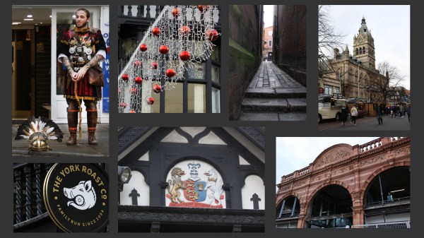
Wrexham County Borough Museum and Archives
The Rossett Lead Pig
www.wrexhamheritage.wales/explore/#rossettpig


Cheshire Proverbs 4: “When the daughter is stolen, shut the Pepper Gate”

“When the daughter is stolen, shut the Pepper Gate”

J.C. Bridge no.387, page 151


Source: Ballads and Legends of Chester by Egerton Leigh, 1867 (full book available online)

This proverb refers specifically to Pepper Street in Chester.  Pepper Gate was presumably located exactly where Newgate was built, along the line of the Roman walls.

Bridge devotes three and a half pages to the proverb, and there is a complete account of one version of the story in Egerton Leigh’s Ballads and Legends of Cheshire.  As Bridge says, the proverb is a local (and more amusing) version of locking the stable door after the horse has bolted.  In this case, it was a girl rather than a horse.  There are two versions of the story, one that claims that she was actually stolen (i.e. kidnapped) and the other that she engineered her own departure through the gate.  In the latter context, the word “stolen” perhaps refers to her lover’s persuasions, convincing her to leave her home and run away with him.  Bridge gives the latter version first:

A daughter of a certain Mayor of Chester was playing at ball – Nausicaa like – with other maidens one fine summer’s day in Pepper Street.  The Gate of the street was shut, but there was a small postern open, and through this the maid threw the ball – no doubt by design though it seemed at the time by accident.  She ran through the postern to get it, and found herself in the arms of her lover who was waiting.  he threw her on his horse, rode off with her and married her.  Hence the Gate was afterwards kept entirely shut. [Bridge, pages 151-152]

A postern is a secondary door or gate to the side of a much larger one, common in castle and church architecture.  Bridge’s reference to Nausicaa refers to a young woman in Homer’s Odyssey.  The daughter of King Alcinous and Queen Arete of Phaeacia is playing ball with her handmaidens whilst waiting for laundry to dry at the water’s edge, unaware that Odysseus has been shipwrecked on their island.  A ball landing in the water wakens Odysseus and although the handmaidens flee in fear, Nausicaa stands her ground.  However, unlike our Pepper Street girl, she never gets together with Odysseus, although there was obviously a lot of meaningful eye-contact going on.

A detail of the delightful (and useful) Chester 1599 map by Braun & Hogenberg, annotated to show Pepper Street and the gate. Source: Sanderus Antique Maps and Books

A thirteenth century story , quoted by Canon Morris, bears a resemblance to the proverb, but involves the daughter being taken by a young man, rather than her running away to him:  “A younge man in the somer season toke a Mayres daughter and bere hur out of Pepur strete as she was playnge at the baule amongst other maydens and youd wyth her awaye and after he maryed the same mayde.”

The identity of the Mayor, the girl and her lover take up much of Bridge’s text.  Again quoting Canon Morris, Bridge repeats a similar story relating to the 1570s in which the father was in fact an alderman, Rauff Aldersey, the daughter Ellen Aldersey and the lover Rauff Jaman, a draper, to whom she was married “by an unlawful minister.”  Both of the men accused of “enticing and stealing away” were said to have been punished with fines.  In both the 13th and 16th Century versions the gate was closed completely at first following this offense, and then, apparently following objections, was open during the day but closed at night.  In Morris’s version the gate is described as “Wolfe-gate or New-gate.”  All three names for the gate are recorded.

Looking around for more on this proverb, I found an online version of the book Ballads and Legends of Cheshire by Egerton Leigh, 1867, which you can download here.  In this version, rhyming and hugely entertaining, the girl is called Rose.  The full story is five small pages long in Leigh’s book.  The opening lines of the tale are shown right, which gives an excellent flavour of it.  I love the bit about girls being prone, at a certain age, to exchanging their dolls for a man with a beard.  A superb insight into teenagers of every era.  The ballad goes on to describe her as a very beautiful young woman:

Her long curling tresses, though dark as the night,
When kissed by the sunbeam shone golden with light.
Her eyes of that sort, should she once glance at you,
You’d forever to all peace of mind wish adieu

Her lover was no less attractive:

He was not the man for whom fair maids might say
That most disagreeable of short words Nay.
Young, noble and handsome and devil-may-care
With the brain to conceive and brave heart to dare
Amongst men a lion; with ladies a lamb;
A look that said, laughing, ‘Refuse me who can!’

According to the ballad, Rose’s father was seriously unimpressed by her suitor’s lack of wealth and was prejudiced against the match, hence the requirement for the ball-game elopement:

Backwards and forwards bounds the ball,
Pursued by nymphs it leaps the wall ;
Through Pepper Gate in crowds they run ;
Back to the street the ball is flung ;
Hotter and hotter grows the fun

And here, Rose is swept up onto her lover’s horse, Lochinvar-style, and the couple ride away into the distance.  Rose’s father was distraught:

Bad news flies fast, and Chester’s mayor
At once began his locks to tear,
Bustled for nothing here and there.
Swore his daughter he’d ne’er forgive;
Vowed her lover should never live !
Declared his wealth he’d leave the poor,
Nor Rose should never cross his door.

The Pepper Gate is blamed by Rose’s father, the mayor, for Rose’s departure, and measures are accordingly taken:

The case is put; it seemed quite clear
That the mayor’s daughter (Rosy dear)
Could not through Pepper Gate have run
Had not the bars been left undone.
They pass a law to close the gate
Through which the wild Rose sought her mate.

The residents of Chester, however, know that this measure is redundant, because Rose has already gone, never to return. It is done anyway, but is derided by the towns-folk:

The townsmen smile : say they, “What for,
“when steed is gone, close stable door ?
When stolen the daughter, all too late
It is to close the Pepper Gate.

In all of the different versions, the girl, whether Ellen or Rose, is long gone, and it’s a bit late to slam shut the gate through which she vanished.

The ballad describes Rose’s lover as Welsh.  Bridge also considers “the original Chester ‘Lochinvar’ ” to be Welsh, basing his suggestion on a Welsh proverb “Gurru, gurru, gurru i’ Caer I briodi merch y Maer” (Trotting, trotting, trotting to Chester to marry the Mayor’s daughter.”

Newgate (formerly, in previous guises, Peppergate and Wolfgate) in 1925. Source: The impressive “Chester: A Virtual Stroll Around the Walls” website (the Newgate page)

Proverbs are time-twisted and tangled, but the themes that emerge from the spaghetti become well-honed and much-tested forms of vernacular wisdom, and are always worth some pondering.  The bolting daughter has not survived in common parlance, but the bolting horse has become a shorthand for (for example) buying a burglar alarm only after the thief has stolen the family jewels.  Such phrases have become so embedded into language that only the first half of the proverb is usually needed to make the required point.  The phrase “shutting the stable door” is nowadays quite sufficient for anyone to know that something was done too late to prevent an undesirable outcome, be it a daughter eloping, a horse bolting, or the family heirlooms being whisked away for nefarious profit.

For more about J.C. Bridge and this Cheshire Proverbs series, see Cheshire Proverbs 1.


The 1898 mile posts between Farndon, Churton, Aldford and Huntington

The milepost just outside Holly Bush Cottage, the nearest one to Farndon, close to the Barnston Monument. It sits at a slight tilt today.  This is the best one for seeing the manufacturer’s logo, which reads W.H. Smith and Co, Makers, Whitchurch. Milestone Society National ID: CH_CHTP08a.  What3Words ///dressing.sublime.lunge

Between Aldford and Farndon there are three very fine 1898 milestones dotted along the road, following the line of the Farndon branch of the old Chester to Worthenbury turnpike (toll road), all on the west side of the road. The photos here show those mileposts that remain between Farndon and Aldford along the B5130.  Other photos show milestones between Aldford and Huntington, plus one in Farndon, but I have no idea if there are some missing along that particular route.  At the moment they are in no particular order but I will eventually, when I have found a few more, organize them from north to south.

The photos of the milestones along the Farndon to Aldford stretch are mine, but the two to the north of Aldford, as the B5130 approaches Huntington, are by other people, found online, because I have not yet managed to track them down in the real world.  Please see the captions for image credits.  All photos can be clicked on to see the bigger image, in which the text on the mileposts can be read clearly (except, of course, where vegetation blocks the view).  For the ones I’ve seen myself, I have taken What Three Words readings to fix the location.  What Three Words is a smartphone app that assigns three words to uniquely describe areas a little smaller than the size of a parking space.  It’s simpler than other location systems, and fixes locations very precisely, world-wide.  It is particularly useful for finding people in emergencies, but I thought it would be useful for enabling people to relocate the mileposts when they become overgrown.  

Churton milepost, next to Greenfields, the last house in Churton at its north on the way to Aldford. Milestone Society Milestone Society National ID CH_CHTP07. What3Words ///blatnatly.backers.comic. My photos, CC BY-NC-ND 4.0

All English turnpike Acts, each created by a separate Act of Parliament, had expired by the end of the 19th Century.  The Local Government Act of 1888 put responsibility for roads into the hands of local councils, making nearly all of the remaining turnpikes redundant.  Sections 92 to 98 of the 1888 Act, however, provided for some exclusions and section 97 enabled Chester County Council to initially avoid taking responsibility for the Chester to Worthenbury turnpike.  Eventually, the Council was forced to take over all the local roads and in 1898 it erected a number of particularly handsome mileposts in Cheshire, including those along the route of the former Chester to Worthenbury turnpike, by then defunct, as well as the Farndon branch of the turnpike.  I have posted about the Chester to Worthenbury turnpike – part 1 about the background to turnpikes and part 2 about the Chester to Worthenbury turnpike in particular.

The milepost outside Glebe Farm, between Churton and Aldford. The red dot is apparently something to do with a cycle race.  Milestone Society National ID CH_CHTP06. What3Words ///decently.hatter.slide. My photos, CC BY-NC-ND 4.0

None of the  mileposts that must have been erected during the 1854 turnpiking of the road have survived.  Milestones or mileposts were erected from the first half of the 17th Century onwards, starting in southeast England, mainly for the benefit of mail coaches and other passenger vehicles.  Turnpikes were merely encouraged to install mile posts from the 1740s but they became a legal requirement from 1766 when it was found that as well as being useful for coachmen and passengers, it enabled accurate measuring of distances for the pricing of different routes.  It also helped to improve improved the reliability of timetables, something to which the turnpikes themselves, had enabled, particularly relevant in bad weather.  Assuming that mileposts were erected when the 1854 turnpike was established, they were presumably removed when the 1898 milestones were installed.

I was unable to find the Crook of Dee milestone, but in the Milestone Society’s survey (over 18 years ago) it is listed it as near Cheaveley Hall Farm, opposite Cheaveley Hall Cottages.  It is marked on the Ordnance Survey Map and on the above Public Map Viewer with the letters MP. Milestone Society National ID CH_CHTP04. Image sources: Geograph and the Cheshire West and Chester Public Map Viewer

The 1898 mileposts are all the same, painted white with black lettering, and consisting of hollow metal posts with two sides meting in the middle, topped with a triangular cap that is tipped towards the road.  The triangular cap says, in all cases, “Chester County Council 1898.”  The two sides, each facing into the oncoming traffic, give the number of miles to key destinations in each direction.  On the southernmost face, the manufacturer’s mark “W.H. Smith and Co., Makers, Whitchurch” is shown below the mileages.  There are no backs on the mileposts.  The ones shown here are in good condition. Being on the side of a very busy road, they are vulnerable to exhaust fumes and road dirt sprayed during rainy periods.  I don’t know who maintains them, but in other parts of Cheshire many have needed to undergo restoration, some having been in very poor condition.  A lot of this work has been lead by the Milestone Society in co-operation with the relevant council.

The Crook of Dee milestone at Cheavely Cottages. What3Words address: ///liner.apprehend.stitch

The survival of these mileposts is remarkable and a pleasure to see.  I have now found all of the ones on the former Chester to Worthenbury turnpike.   I only found the Crook of Dee milepost in November 2021, after hunting for it for ages.  It was completely concealed by undergrowth in the summer and it was only after leaf fall, and with the hedge cut back, that I eventually found it, covered in ivy but still there.  The photograph of the Crook of Dee shown above left, decoratively peeping through a fine show of dandelions and dead nettles is from the Geograph website, taken during the Milestone Society’s national survey over 18 years ago, and is a particularly nice photograph so I have left it here.  My own photograph is at right.  I cleared the ivy as best I could on a very dangerous stretch of road with no footpath and only a tiny verge, but it is in fair condition, albeit very rusty.  The What3Words address for it is shown on the image to the right.  It is located opposite the Cheaveley Hall Cottages,

Huntington milestone. What3Words ///shine.knee.reject

There is also one at Huntington, for which I kept an eye open for months, and found on the same day as the Cheaveley Hall one.  It is shown left, along with its What3Words location.  It is in excellent condition on a grass verge, just north of a pedestrian crossing.

The Ordnance Survey map, shows another run of mileposts between Churton and Worthenbury.  The first heading south from Churton towards Worthenbury should be somewhere along Sibbersfield Way (which I have repeatedly looked out for in the car when nothing has been behind me, but I still haven’t found)

The rest on the leg of the road south of the bypass that runs towards Worthenbury via Crewe by Farndon and Shocklach through blissful rural fields and past several estates and  farms. I made an attempt to locate them during the summer, few months later I found the one to the north of Crewe by Farndon, which had been revealed by hedge-cutting.  It is in the grass verge on the west side of the road, just before Caldecott Farm.

Not so shiny and new as some of them, but still hanging on in there!  It is located just short of a farm on the left heading south (the east), and is on the west side of the road about two or so metres to the right of a telegraph pole.  I will go back and get an exact What Three Words location for it next time I’m in that area, but for the time being it is roughly at ///rainfall.duplicity.proofs.

During the summer I was able to find the nice one in Shocklach, thankfully not hiding in a hedge and at that time pleasingly accompanied by some lovely roses.

The milepost at Shocklach, on the route to Worthenbury. Milestone Society National ID CH_CHTP12. My photo, CC BY-NC-ND 4.0

I suspect that the rest are still hiding in overgrown verges.  As with the Crook of Dee milepost, as the vegetation dies down this winter I will continue to look for them.  When I have the full set I’ll put them into north-south order.

The Sibbersfield Lane milepost, which is on the stretch of road from Churton towards Crewe-by-Farndon, about halfway down before reaching the bypass, is slowly diving into a ditch.  It’s a terrible photograph but I was not going to risk getting out of the car to take it, as it is a very nasty and fast stretch of road.  I forgot to take its What3Words location, but will go back and re-take the photograph and note the location on a quiet day, preferably when the road is closed!  Taken in March 2022:

In May 2022 I was diverted due to the Holt-Farndon bridge closure down Barton Road, the road that runs through Farndon from the bridge, and noticed a milestone on the south side of the road.  I was in a hurry so didn’t stop, but went back in early July, half expecting it to be completely subsumed into the hedge that stood behind it, but not a chance.  Someone is looking after it beautifully (with thanks).  It’s What3Words location is ///warned.tower.mascots, which you can see on a map at https://what3words.com/warned.tower.mascots.


Sources:

Books and papers

Benford, M. 2002. Milestones.  Shire Publications

Crosby, A.G. 2012.  New Roads for Old. Cheshire Turnpikes in the Landscape 1700-1850.  In (eds.) Varey, S.M. and White, G.J. Landscape History Discoveries in the North West.  University of Chester Press, p.190-223.

Local Government Act 1888 (51 and 52 Vict. c.41). Section 97, Saving as to liability for main roads.

Wright, G. N. 1992. Turnpike Roads. Shire Publications Ltd.

Websites

Milestone Society Restorations in Cheshire 2008-2009
The Milestone Society
https://www.milestonesociety.co.uk/archives/Downloads/In%202008%208-Cheshire%20County%20Council%20Highways%20Services%20were%20suc..pdf 

Turnpike Roads in England and Wales
Turnpikes.org.uk
http://www.turnpikes.org.uk/Tollhouse%20design.htm