The Chester Archaeological Society 2024 season of excursions started excellently today with the CAS visit to the Church of St Collen, who gave his name to Llangollen. It is the only church in Wales to have taken the saint’s name. Like most Medieval churches in Wales, St Collen’s has undergone considerable alterations, including an 18thcentury tower and a 19th century chancel, vestry and south nave, but there are some very fine 13th century features to be seen, in the Perpendicular Gothic style, including an impressive shrine canopy and mason’s marks. There are also intriguing signs that a Lady Chapel was once incorporated into north aisle. The most remarkable feature of the church is a really superb hammerbeam roof bedecked with ornamental sculptures, both religious and secular, from the early 16th century.
Today, to ensure the survival of the church as a living and breathing community asset, it is undergoing extensive but very sympathetic re-forming. Suzanne Evans is the Project Manager of this massive task, and was our superb guide today. Suzanne described how the reinvented church will be fully inclusive, not only of the existing congregation who are much-attached to the church, but of the wider community as well, taking into account the needs of those currently unable to make the most of what St Collen’s has to offer. At the same time, the exciting opportunity will be taken to investigate as much of the church’s architectural and funerary history as possible, adding to the community’s understanding of this important contributor to the town’s impressive ecclesiastical heritage.
Suzanne guided us around both the key features and recent discoveries, explaining all the steps to be taken in the upcoming weeks and years. As well as replacement glass doors and the opening up of the nave to enable the interior to be visible by passers-by, there will be new lighting, heating, kitchen and toilet facilities, as well as a large stage, which will all contribute to enhancing the value of the space and improving the visibility of the superb architecture. All archaeological and architectural discoveries will be professionally recorded and published.
After a very welcome cup of tea, there was a round of applause as we thanked both Suzanne for being our terrific guide and Pauline for making all the arrangements. It was great to meet some of the other CAS members, and to hear all the questions and observations. There was a lot of information sharing, which is exactly what one expects of CAS members. What a great start to the year’s excursions! Many thanks again Suzanne and Pauline.
This is a slight departure for this blog, the usual premise of which is that every visit can be accomplished in a day, there and back, from where I live in Churton. The visit to Peterborough required a stop overnight. I have always wanted to see the Romanesque cathedral at Peterborough, which is a former Benedictine abbey. I set out by car early on a Wednesday in November 2023 and stayed one night in Peterborough near the town centre, visiting the cathedral both on the Wednesday afternoon and again on the Thursday morning. On my way home on Thursday afternoon I visited the lovely Normanton Church. The routes taken and other visiting details are at the end.
Peterborough Cathedral is covered in part 1 (here) and a very brief snapshot of Normanton Church on its custom-made plinth on Rutland Water is in part 2. Needless to say, I have barely skimmed the surface of the cathedral’s history.
Introduction
South transept
Peterborough Cathedral is somewhere I have wanted to visit from the moment that I laid eyes on photos of it in a book. It has an almost split personality with its magnificent and unique 3-bay Gothic frontage, its sublime Norman-Romanesque interior, the stunning painted nave ceiling and the almost organic delicacy of the fan vaulting in the date eastern extension.
The abbey was terminated in Henry VIII’s dissolution of all the monasteries, but like Chester Cathedral was fortunate to escape some of the indignities of this process when it was converted to a cathedral. The building that visitors see today, dedicated to St Peter with St Paul and St Andrew, is the third abbey. The first abbey, Medeshamstede, was destroyed by Danish invaders. The second abbey church, built over a century after the demolition of the first, burned down by accident although the cloisters survived. The third abbey church was started from scratch, and is remarkable for the survival of the magnificent Romanesque vision. All three abbeys were built on the same site, and there is some evidence for a Roman building beneath them. The three phases are described very briefly below. For detailed descriptions see one of the guide books available, or the cathedral website’s History page (details in Sources at the end). If you go in person, I recommend the guided tour.
The 7th Century Abbey – Medeshamstede
Artist’s impression of Medhamstede, shown on an information poster in the cathedral
Bede’s 8th century Ecclesiastical History says that the first abbey on the site, Medehamstede, was established in the 7th century, and it is now thought that it was founded in around 654, and was probably built of wood. A later phase may have seen the rebuild of the wooden walls in stone, imported from a quarry to the west. Very little is known about the building and its phases, although the artist’s impression to the right is a useful suggestion of what might have been on the site. The first abbey was very isolated, deliberately divorced from human settlement to provide a suitable environment for contemplation and prayer.
The River Nene in Peterborough
Perched on the side of the River Nene and on the edge of the marshlands and mudflats of the Fens, it was an ideal location for peaceful contemplation and prayer. For this and subsequent abbeys on the site the nearby marshy Fenlands provided one of the best resources for freshwater fish in England, offered a rich habitat for wildfowl and supported reed beds that provided the raw materials for thatching roofs. The land also had the farming potential required for an expanding self-sufficient and isolationist community, providing summer pasture for livestock, and later on, when improved techniques of land drainage were mastered, the opportunity for agricultural development. Communication links were provided by the River Nene and the nearby Roman road.
The monastic community would have been organized along very austere lines adhering to the so-called Celtic tradition of monasticism. The abbey became an important early religious centre, and founded a number of daughter houses in Leicestershire, Northamptonshire, Kent, Surrey, and Bermondsey (now in southeast London), which were important vanguards of the spread of Christianity. I
The Hedda Stone
Housed today in the cathedral chancel / presbytery is the Hedda Stone shown above, a large and beautifully sculpted piece of limestone belonging to this period of the abbey’s history, showing Christ, Mary and the Apostles. It is carved on both sides and pierced with holes that have no generally agreed purpose. It is quite easy to miss, so do make a point of finding it, as it is delightful.
In 870 the abbey was plundered and destroyed during a Danish attack on the east coast, and the site, now abandoned, became part of the Danelaw territory.
The 10th Century Abbey – Gildenburgh
Plan of Saxon and Medieval Peterborough showing the outline of the second church. F is the site of the gate stormed by Hereward and the Danes. It is thought that E is the old marketplace, replaced by the new town in 1133-1155. The motte is thought today to have been built by Abbot Thorold. Source: Current Archaeology 89, 1983
In the 10th century, Æthelwold of Winchester had a vision of Christ in which he was instructed to rebuild the abbey of St Peter. He was assisted in this challenge by Dunstan of Canterbury and by King Edgar and Queen Ælfthryth. It was consecrated in the early 970s by Dunstan as a Benedictine monastery (i.e. one following the guidelines for monastic life developed in the 6th century by St Bendict of Nursia, Italy). From fairly early on it was decided to provide it with a defensive wall, making it a fortified settlement or “burgh.” The church was laid out along traditional lines with a nave, two transepts and a chancel at its east end. It must have been provided with a belfry, because Æthelwold provided 10 bells for the church. Although there were no sources of stone and wood close to the site, these were imported from Barnack and Rockingham Forest respectively.
The prestige of the monastery rose when it acquired an important relic, the right arm of Oswald, a Saxon king and saint who was noted for his kindness to the poor and whose arm, with which he handed out so many alms, survived, perfectly preserved, after he was killed in battle. The monastery’s position was again strengthened in 1041 when one of the monks, Æthelric, was chosen as Bishop of Durham. The selection of the abbey as the final resting place for Ælfric Puttoc and subsequently Cynesige, both archbishops of York was an indication of how well regarded the abbey was in the 11th century. Like many Benedictine monasteries, it became a major landowner, becoming wealthy and both economically and architecturally ambitious, accumulating books for a library, and fine objects for its ceremonies and liturgies. It was so rich that it became known as the golden burgh, Gildenburgh.
Reconstruction of the abbey precinct at the time of Hereward’s attack. Source: Peterborough Abbey
The second abbey was still standing proud when William the Conqueror landed in England. Its abbot, Leofric, died in the Battle of Hastings. Abbot Brand, who followed him, was also Saxon and supported opposition to the Norman invasion. This opposition was punished with heavy taxation, and when Brand died in 1069 the abbey was put into the hands of an abbot, Thorold, loyal to William. In the event, a local Saxon rebel, Hereward, had found an ally in King Swein of Denmark, and in 1070 the Saxons and the Danes marched on Peterborough and plundered it. Although the arm of St Oswald was saved by the prior (second in command) the rest of the treasure vanished with the rebels. The abbey itself was badly damaged, and what survived was occupied by the abbot and sixty knights and significant portions of land that had once formed the basis of the abbey’s wealth was now allocated to many of those knights, filling the formerly rebellious countryside with loyal Normans.
When Thorold died in 1098 he was replaced by two successive abbots who had very little impact, but the third abbot to be appointed, in 1107, was Ernulf who was prior of Canterbury, a scholar with a good understanding of political manoeuvring, who had plenty of ambition for his new posting. He began by rebuilding the damage to the cloister buildings that had been largely destroyed by Hereward. In 1114 Ernulf moved on to Rochester and was replaced by Abbot John de Séez.
In early August 1116 when a fire broke out in the bakery and took most of what remained of the abbey church with it, although Ernulf’s new claustral buildings survived beyond the abbey church. A new church was now not only desirable but necessary.
Today’s abbey, established in the 12th Century
The Romanesque architecture
Plan of Peterborough Cathedral. Click to expand. NB – the “sanctuary” is referred to in most of the Peterborough Abbey literature as “presbytery” so I have stuck with the latter throughout. Source: Sweeting 1899, Project Gutenberg
Abbot John de Séez oversaw the construction of a stunning new Romanesque building, complete with a vast vaulted presbytery. The scale of his ambition saddled the abbey with such an enormous financial and logistical commitment that it took 120 years to complete. Masons who had worked at Durham were brought in to ensure that the most up to date civil engineering techniques were employed, and what unfolded was a mixture of magnificent vision and superb skills. The church was laid out on the usual cross-shape, with a long nave, side transepts (containing chapels) and a shorter east end. The south wall of the church (the righ thand side of the plan) made up the north wall of the cloisters, the administrative and domestic buildings were located, arranged around a square garden called the garth.
Entering the nave, the interior is light-filled and breathtaking. With windows on three levels, light pours in. Cromwell’s soldiers destroyed the medieval stained glass, and the plain replacement glass allows in much more light than the stained glass would have permitted. Of course it does help that the cathedral has installed artificial lighting, but even allowing for the changes, the layers of window and the soft, faintly reflective pallor of the Barnack limestone walls must have provided a degree of light that was remarkable in the Middle Ages.
View from just inside the west entrance to the end of the presbytery, with the pulpit in the foreground, and the modern rood (crucifix) hanging over the entrance to the Victorian choir
Because there is no surviving pulpitum (a stone division between nave and choir in monastic churches) or rood screen (again, between nave and choir), there is a very rare almost uninterrupted view from the west end entrance to the restored stained glass windows at the east end. In spite of the 19th century marble edifice that sticks up in the middle of the presbytery, the impression of a vanishing point is dramatic and gives a real sense of the length of the building. The walls soar upwards too, meeting a unique and fabulous painted ceiling.
On the death of Abbot John, the new Abbot Benedict, from Canterbury, persisted with the same vision. This is interesting because at Canterbury new ideas from France, captured in the Gothic style, were being implemented, but for whatever long-lost reason, Benedict retained the Romanesque plan that Abbot John had initiated, including semi-circular apses at the east end, one of which survives within the rectangular “New Building” that surrounds it. This apse is a rare survivor as most British churches had their apses removed for replacement by rectangular extensions such as Lady Chapels and similarly prestigious expansion projects. Benedict extended the original design west by two bays, and if you stand at the west end and look at the arches of the aisles you can clearly see the difference.
Blind arcading in the north aisle beneath the great arches of the windows
The nave and the two transepts contain the bulk of the easily visible Romanesque architecture. That within the east end presbytery is more difficult to view. The long nave with its side aisles is monumental. The massive arches of the aisles, with characteristic geometric decoration, are supported on vast octagonal piers. They are topped with another set of arches, each of which contains twin arches separated by slender columns topped with square capitals. The top level features rather smaller central arches, each flanked by even smaller blind arcades. The transept ends are simpler, each with three levels of of arches, each of the same size, with unpainted roof panels in the same lozenge shapes as those in the nave.
The lost cloister and infirmary
Artist’s impression of the cloister on an information board in the remains of the abbey cloisters.
Today’s cathedral was once the abbey church, and is a wonderful survival, but it was only one part of the monastic establishment. A cloister was always an integral part of the monastic establishment, with buildings along three sides of a courtyard or garden, with the church making up the fourth side. This cloister was usually on the south side of the church, sheltering it from the worst weather and providing it with seasonal sun. The central part of it was often a garden of some description, called the garth. The buildings arranged along the three sides included the refectory, where the monks ate, the dormitory where they slept and the chapter house where they held daily meetings. Some of these buildings could be very elaborate and ornate, particularly the chapter house.
If you leave through a door in the south side of the cathedral (on the right as you head from the entrance towards the end of the nave) or turn right in front of the cathedral and head down a narrow pathway, you will find yourself in what remains of the cloister. There is some very fine stonework left behind, giving a hint at the magnificent buildings that once stood here, and many of the changes that the buildings clearly underwent. The buildings were robbed for building materials following the Civil War.
Cloister wall, where it meets the abbey church
Beyond the cloister was the infirmary. Many monastic establishments were furnished with an infirmary, mainly to take care of the elderly and unwell within the monastic community, but most of these are long gone, and again there is some attractive gothic arcading that indicates where the monastic ifirmary was located, to the east of the cloister. It was built by Abbot John de Caux in around 1250. It is worth mentioning, because it gives some idea of the scale of the monastic operation at Peterborough.
Relics
The 12th century Becket Casket (Height 29.5cm; Width 34.4cm; Depth 12.4cm). Source: V&A Museum
No important abbey was viable without relics of saints, which gave it great spiritual credibility, prestige and integrity. Amongst the valuable relics collected were the arm of the Saxon saint Oswald of Northumbria. More prestigious by the 12th century were the bloodstained objects directly connected to the murder on 29th December 1170 of St Thomas Becket of Canterbury (the reliquary for which survives in the V&A museum). A 12th century genuine British martyr, canonized in 1173, was a remarkable thing, and the snaffling of authenticated relics for Peterborough was a real coup. Benedict did not witness the martyrdom, but he became an ardent collector and collator of Becket miracles. Becket had actually been to Peterborough, visiting with King Henry II in 1154. A chapel was built to St Thomas at the abbey gate in 1174 to hold this and other relics, allowing pilgrims access to monastic relics without permitting them to disrupt the abbey church itself.
Painted walls and woodwork
Romanesque cathedrals in Europe often preserve painted decorative patterns on walls and ceilings, some emulating red mortar, but only faint hints survive in Britain. Fortunately, some very delicate paintwork in Peterborough survives. As well as imitation mortar, and some lovely swirling curves, there is a truly charming section on the ceiling with tiny red flowers that may have been intended to evoke the Virgin Mary, who is often associated with red and white roses.
Within the apse, at the rear of the Presybytery, accessible from the New Building ambulatory, there are coats of arms painted on the white walls. Given that the eye is inevitably drawn first to the Hedda stone and the enormous marble high altar, it is easy not to notice the paintings. I have been unable to find out anything about them either in the literature I have to hand or on the Peterborough Cathedral website, but they probably belonged to wealthy benefactors of the abbey or the later cathedral.
The chapels in the south transept were provided with wooden screens to provide access and entry, and provide privacy. Remarkably, some of the decorative painting on these also survives.
The west front, the porch and the Lady Chapel
The Romanesque building did not escape the fashion for Gothic style embellishments. Tracery in the window arches, for example, is Gothic, and the Romanesque interior was topped and tailed with a remarkable Early English west front and a stunning fan-vaulted rectangular ambulatory around the central semi-circular apse at the east end.
The unique 3-bay frontage was started in 1195 but progress was halted when King John, and England as a whole, were excommunicated from the Catholic church in 1209. When the crisis was over, building resumed under Abbot Hugh, and it is thought that he made some changes the original design. The result is three 29m high arches at the front, the central one narrower than the two flanking ones. Inset into these are further arches. Flanking the arche tops and and built into the triangular gables above were a total of 22 figures looking out from the front, although many have crumbled and have now replaced. The three at the top of the gables are Saints Paul, Peter and Andrew. The figure at the very top of the central gable is St Peter, overlooking the entrance, and marking the transition from the impure outdoor world to the heavenly space within.
Following the 13th century fashion for adding a Lady Chapel to a church, dedicated to the Virgin Mary, one was built at Peterborough 1272-1286 to the north of the presbytery, accessed from the north transept, and was still standing by the 17th century, when it was taken down during the Civil War. It was in the Gothic style and was probably elaborately decorated and furnished.
A later Gothic porch, dating to 1375, protrudes from the middle of the west front. I was inclined to be more than a little judgmental about the porch, which looked like a very misguided vanity project, but I stand corrected. It was found that the central arch of the west front was beginning to tip forward, and the engineering solution was to create a wedge to prop it up. The structurally necessary wedge was designed as a Gothic style galilee porch with perpendicular windows, and although it breaks up the magnificent frontage, has done a great job of preventing its collapse.
The 15th century “New Building”
The so-called “New Building,” a sublime gothic vision, is in fact an eastward extension of the Romanesque cathedral. The New Building was probably built between 1496 and 1508 by star architect John Wastell of Bury St Edmunds (later responsible for the fan vaulting at Westminster Abbe, under the abbey’s superior, Abbot Robert Kirkton. This was no mere add-on, but a fabulously imagined and beautifully crafted piece of fan-vaulted delight. The abbot who took the gamble of gluing on an extension to a perfectly conceived Romanesque delight lived up to the legacy of his predecessors. The ceiling bosses, some of which are shown in the above photograph, were carved with both secular and religious themes showing coats of arms, symbols of the saints, and other familiar subjects. The job of the extension was to enclose the central semi-circular apse within a rectangular extension, providing a low-level ambulatory around the inner sanctum, which rises above it, for ceremonial processions. Ambulatories often contain additional chapels, but the cathedral’s architecture remains largely uninterrupted and therefore retains the impact of the fabulous fan-vaulting, which is one of the largest examples in England.
Ceiling boss showing the instruments of the passion
The New Building also, of course, delivered some fairly glossy feathers to the cap of the abbot who was so pleased with himself that he incorporated his name, a partial rebus, into the building itself. Abbot Robert Kirkton was not a self-effacing man – his initials are also conspicuous in the elaborate Prior’s Gate that he built and which celebrated key royal figures in the form of their heraldry, and ornamented with Marian roses, managing to be both obsequious and self-congratulatory.
Prior’s Gate by Abbot Kirkham
The unique 13th century painted ceiling
Magnificent painted ceiling of the nave
Deserving a post in its own right, the wooden ceiling is a marvel. Unique, it was started in around 1238 and was finsihed sometime in the 1240s. It is made up of a series of lozenge-shaped panels, which one painted either with a small scene or with leaf and floral motifs. The repeating pattern of the lozenges is dramatic from below. Interpretation of the scenes has established that the individual subjects are arranged into a series of core themes, but there is much that it still unclear. Obvioulsy religious scenes like the Creation, The Lamb of God, Saints Peter and Paul and the Anti-Christ are accompanied by historical clerics and kings, music, astronomy and the liberal arts. A scene showing a money riding backwards on a galloping goat whilst holding an owl is a representation of folly. John Foyles dedicates several pages to the ceiling in his book and there is a book about it by Jackie Hall and Susan Wright for those who want to delve deeper (see sources at the end).
Unpainted wooden ceilings over the apses are also arranged in lozenges, and are very fine in their own right.
Lozenge-shaped framed painting on the ceiling of the nave., showing St Paul holding a sword in his right hand and a book in his left (panel C7). The sword evokes the means of his martyrdom (beheading) and the book represents his epistles.
The Tudors before the Dissolution
The main contribution of the Tudors to the cathedral are the tombs of Katherine of Aragon, who died in 1536 and Mary Queen of Scots in 1587.
Katharine of Aragon had been married to the heir to the English throne, Arthur, elder brother of the future Henry VIII. When Arthur died, Henry VIII married his widowed sister-in-law. When the marriage failed to produce the necessary male heir, Henry decided to annul the marriage. Unable to obtain papal permission to do so, he split from the papacy and established the Church of England. Katherine was shuffled off to Kimbolton Castle, where Henry hoped that if she was out of sight of the public, she would also be out of mind. When she died she provided, on Henry’s orders, with a tomb in Peterborough Abbey, the nearest important ecclesiastical building to Kimbolton. Here she was identified as the widow of Henry’s brother Arthur. This was presumably Henry’s excuse for not granting her a place in Westminster Abbey. Deposited under the floor up against the south side of the presbytery, where she would be close to God, she was provided with a monument above the grave. This was destroyed in the Civil War, but the grave beneath remainsin situ, marked by a stone slab and gold lettering.
The Dissolution
The opening page of the Valor Ecclesiasticus (the survey of monastic establishments that paved the way to the Dissolution), showing Henry VIII. Source: Wikipedia
The New Building had only just been finished in the first years of the 1500s when Henry VIII fell out with the Catholic papacy. Henry, having found a way to both dissolve a marriage that produced a daughter but no male heir to his throne, and simultaneously remove papal authority over both his personal affairs and the management of the church, also found that being the head of his own Church of England enabled him to raise substantial funds by laying claim to all the properties and goods of the monasteries, priories and friaries, by simply denying their ongoing right to exist. The Dissolution caught up with Peterborough abbey in 1539, which had survived the first round of closures that took place in 1536. The abbot at the time was John Chambers, and he was unusually fortunate. He took no part in the protests in Lincoln or the Pilgrimage of Grace, and although initially pensioned off his meek resignation to the inevitable was rewarded. Whether it was because of the creation of new dioceses at this time, or because Henry VIII’s first wife Katherine of Aragon was buried here in 1536, the abbey escaped demolition and was converted instead to a cathedral in 1541 with John Chambers as its first bishop. Of all the 100s of abbeys, priories and friaries that were dissolved by Henry VIII, only a handful were converted to cathedrals, of which Chester Cathedral is another example.
Fifty years later Peterborough was again the royal choice of burial place for an embarrassing queen. Executed in 1587, Mary Queen of Scots was buried on the opposite side of the presbytery from Queen Katharine. She remained there for 25 years until her son, James I, removed her remains to Westminster Abbey.
The Civil War
Peterborough, from Speed’s 1610 map, shortly before the Civil War. Source: Sweeting 1899, Project Gutenberg
During the English Civil War of 22 August 1642 – 3 September 1651, each side attempted to use the medieval castles to gain advantage. The result was that many 13th century castles were slighted (demolished) to prevent re-use at the end of the Civil War. Castles were fair game, but religious institutions were also targeted because they represented a different threat – the challenge to Puritan religious belief. Henry VIII had rejected Catholic authority, but his Church of England was established for convenience, and the Church of England contained many lingering aspects of its Catholic ancestry. Oliver Cromwell’s soldiers were given free reign to obliterate any of the artistic signs of lingering tendencies to papism to force through reform. What they could reach they either maimed or destroyed. What they could not reach they sometimes hit with musket fire.
One of three surviving misericords at Peterborough Cathedral
At Peterborough, as in so many places, the medieval stained glass was demolished. Some of the stained glass windows at the east end today was formed of the fragments that people picked up and saved after the Puritans had left. The painted ceiling over the east end apse was shot with muskets, but somehow the ceiling over the nave was missed. The choir stalls, together with the misericords (the so-called mercy seats once in the choir stalls, all of which were carved with fascinating scenes on their undersides) were also destroyed at this time. Only three of the misericords survive (at Chester there are 48 misericords, which gives some idea of the level of destruction at Peterborough). The survivors are preserved in a chapel on the south side of the nave near the entrance, a sad reminder that something quite spectacular has been lost. The high altar was also destroyed. The cloister buildings were used as the raw materials for nearby Thorpe Hall.
The 17th and 18th centuries
This sub-heading would normally be an exercise in naming and shaming, but, amazingly, the abbey has not suffered the usual indignities of an important ecclesiastical building during this period. There are no 17th and 18th century monuments jostling for position on the walls to undermine the sense of coherence and uniform splendour. The soaring nave in Westminster Abbey, utterly spoiled by truly awful funerary memorials, is a good example of how badly a beautiful building can be dramatically undermined by later insensitivities. Although some of the monuments in Peterborough Cathedral were damaged during the Reformation, there seem to have been restrictions on the number permitted.
The biggest surviving monument is baroque, dedicated to wool merchant Thomas Deacon, former high sheriff of Northamptonshire and founder of a charity school for 20 boys. He died in 1730. His wife, who died 10 years later, is also commemorated on the monument. I would much rather that it had not been built in the cathedral, at the entrance to the New Building, because it is such an alien presence, but it is a particularly fine example of its type.
The Victorians
Two of the most active restorers of the Victorian period were Sir George Gilbert Scott and John L. Pearson. Unfortunately, although their ideas of restoration included the valuable rescue and repair of serious damage and decay, it also involved what they clearly thought of as improvements to the original vision of earlier architects and artists. Enthusiasts of Chester Cathedral and Valle Crucis Abbey in Llangollen will probably have Gilbert Scott’s name ringing in their ears.
The crossing
In the late 1800s the tower was on the verge of collapse and it was Pearson who was responsible for dismantling and rebuilding it, a massive undertaking that saved the cathedral from irreparable harm. His work altered the 14th century tower but was done to blend in with the existing architecture. The twin sets of choir stalls, to the east of where the originals were located, the cathedra (bishop’s throne) and the pulpit are also Pearson’s work, and although clearly not medieval, are a skilled emulation of a medieval style quire. Pearson’s, however, was the evil genius that created the temple-like marble high altar within the presbytery as well as the cosmati floor leading up to it.
Cosmati floor
Gilbert Scott was responsible for the painted ceiling over the apse, which he claimed at the time was based on the damaged example that he was replacing. It is unmistakeably Victorian in its rendition and colouring.
Gilbert Scott’s ceiling in the apse
In this period the circular cast iron Gurney stoves were added, manufactured by The London Warming and Ventilating Company who bought the patent registered in 1856 by Goldsworth Gurney, surgeon turned engineer. The stove looks like the filter in my wet-and-dry vacuum cleaner, with ribs standing out from a central cylinder, distributing heat in a full circle. It was fired by anthracite, and the entire thing sat in a trough of water, helping to add humidity to the air. Peterborough cathedral retains several of them, and they are in many other cathedrals too. The Peterborough ones are powered by either as or oil, and they do a stunning job.
Modern additions
There has been some restoration work in the last few decades, but the emphasis has generally been on preservation rather than modernization. For example, many of the badly decaying figures on the west front were replaced by Alan Durst between 1949 and 1975.
A particularly noticeable modern addition is a hanging rood – a red crucifix with Christ in gold affixed to it, suspended from the ceiling at the east end of the nave, added in 1975. This hangs above the line that the rood screen would have taken across the nave. Up against the south side of the presbytery some very fine gold lettering, was put in place to mark the burial place of Mary Queen of Scots, which works well. In the New Building, someone has seen fit to place framed photographs on the walls between the fan-vaulting columns, which really doesn’t do the architecture any favours. The entrance to the west end has automated glass doors, which add to the light, and there is of course the inevitable gift shop on your left as you enter. Outside, Thomas Becket’s chapel is now a tea room.
Final Comments
The Romanesque is so comparatively rare in Britain, that this stunningly coherent and unfettered example is a particularly amazing treat. When the decision was made to extend the east end in a contrasting style, the slender, delicate columns and fan-vaulting of the New Building provided contrasting but additional brilliance. Moving through the building from the Norman to gothic gives the sense of being in an ecclesiastical time machine, a transition from one perfect world to another.
There is so much more to be said about the abbey and its features, inside and out, so much that has been missed out here. If you decide to visit, you won’t be disappointed.
Visiting
View from the choir to the east end
I am accustomed to driving to southeast London, so rather than looking at other options I took was my usual route, zipping down the A41, the M54, the M6 and the A14. From the A14 the A605 goes straight to Peterborough and I was there, end to end with no delays, in just over three hours. The A41 is always the joker in the pack because it is a long way from Chester to the M54, there are very few sections of dual carriageway and it can be difficult to overtake if you find yourself behind something slow. The A5 to Shrewsbury and the M54 is sometimes quicker.
The cathedral opening times are on the website, where any special events and closures are shown. Although I had done some top-level background reading I was lucky enough to arrive half an hour before a Highlights Tour was due to start, so I had a wander around on my own and then returned to the entrance for the tour. I failed to get my guide’s name, which is particularly sad as I had her to myself, November being a quiet time of year, and we had a great chat. She was splendidly knowledgable, encouraged my stream of questions and added multiple layers of detail and interpretation to my visit.
There was full-on white frost resembling snow over the days that I visited, and it was exceedingly cold, but thanks to the deployment of multiple Gurney stoves in the cathedral (fabulous heat-generating monsters like the ones in Chester Cathedral), I actually had to take off my top layer. It is the first cathedral I’ve ever visited that actually felt cosy!
For those who are dealing with unwilling legs, Peterborough as a whole is on the flat. The cathedral has very few steps to negotiate, automated doors provide access to the cathedral, a ramp is provided to get into the chancel from the New Building to visit the Hedda stone, and there are a great many places to sit down even beyond the nave.
I returned home via Normanton Church (see my short post with photos), for no better reason than it looked pretty and I do love a well-proportioned Georgian church, so my return journey was different, following the A606 to Melton Mowbray (I didn’t stop but it looks interesting), the A6006 and the A50 to Stoke on Trent and Nantwich, and the A534 home. Thanks to a convoy of lorries on the A6006 it was slow going but it was a spectacularly beautiful day and the unfamiliar landscape showed to terrific advantage in the sunshine. The A50 is dual carriageway, very unlovely but a smooth run. The drive from Peterborough to Churton, via Normanton Church, took me just over four hours (not including the time wandering around at Normanton).
Sources
Books and papers
Pair of figures believed to be Roman, possibly late 2nd century. In the west wall of the south transept
Biddick, Kathleen. 1992. The Other Economy: Pastoral Husbandry on a Medieval Estate. University of California Press
Foyle, Jonathan. 2018. Peterborough Cathedral. A Glimpse of Heaven. Scala
Higham, Jack (Revd. Canon). 2001. Peterborough Cathedral. The Pitkin Guide. Pitkin
Selkirk, Andrew and Selkirk, Wendy 1983. Peterborough. Current Archaeology, no.89, vol.VIII, October 1983, p.182-183
Sweeting, W.D. (Revd.) 1899 (second edition). The Cathedral Church of Peterborough. A Description of its fabric and a Brief History of the Episcopal See. G. Bell and Sons Ltd. https://www.gutenberg.org/files/13618/13618-h/13618-h.htm
Book about the nave’s painted ceiling (which I have not read, but is listed here for those who would like to find out more)
Jackie Hall and Susan Wright (eds.) 2015. Conservation & Discovery: Peterborough Cathedral Nave Ceiling and Related Structures. MOLA———
Although quite literally freezing cold, the sun was stunning yesterday so on the spur of the moment, having just run an errand to Rossett, I plotted a route to the National Waterways Museum at Ellesmere Port on the Wirral. It’s very easy to find, being just off the M53. I have been meaning to visit ever since I moved to this area. It is one of those places best done in dry weather, because there is as just as much, if not more, to see outside as indoors. Visitor information details are at the end.
Background History
The museum occupies the 19th century canal and port complex, re-using the lovely brick-built buildings for exhibits and displays and using sections of the docks and basins for a number of fascinating canal and waterway vessels. Ellesmere Port was the largest Inland Waterway dock complex in the United Kingdom. The name Ellesmere Port refers to the town of Ellesmere, where many of the decisions about the Shropshire Union canal network were made. There was no Ellesmere Port until the port was established in 1796 as a small base at the Mersey end of the Shropshire Union Canal.
The Shropshire Union Canal was one of a number of canals built at different times which, in 1846, were amalgamated into a single operational network. The earliest part of this network was the Nantwich to Canal section. The earliest part of the system was the Chester Canal which ran from Chester to Nantwich in 1772. It was not until 1793 that a section connecting Chester to the Mersey was built, with its terminus at Ellesmere Port. The section from Nantwich to Birmingham, the Birmingham and Liverpool Junction Canal, was the main north-south artery of this network, and was not completed until 1835, joining the national canal network for which Birmingham was the central hub.
By 1802 as well as a series of locks with a lock keeper’s house, there was also three basins, wet and dry docks, a small wharf, a clerk’s house and a canal lighthouse. Over subsequent decades additional wharves were added and warehouses, workshops and sheds were built. A scheme by Thomas Telford for a dock and entrance for seagoing vessels was completed in 1843, significantly improving the port’s suitability for transhipping. During the 1850s the most important cargo was iron, followed by ceramics from the Potteries, and substantial facilities were provided for both.
The opening of the Manchester Ship Canal in 1894, and the simultaneous improvement in facilities at Ellesmere Port significantly improved the prosperity of the port. Unfortunately this was something of a swansong for the canal port, and In 1921 the Shropshire Union Canal Company sold its fleet of barges and the commercial viability of the canal and the port for freight handling came to an end. The railways replaced the canals throughout Britain, with many of the former wharves and ports falling into disuse and dereliction. Ellesmere Port managed to survive until the 1950s and became a museum in the 1970s.
More details of the history of the port, (together with some of the business and industries it attracted, the development of the surrounding settlement and details of the drainage of Stanlow marshes by German prisoners of war in the First World War), are available in Vince Devine and Jo Clark’s excellent survey (see Sources at end).
The Museum
The derelict port buildings became a museum in the 1970s after a heroic effort by a group of volunteers, and is now a conservation area with nineteen Grade II listed buildings. It was originally known as the North West Museum of Inland Navigation and had various other names until it became The National Waterways Museum, with its emphasis on inland waterways, both rivers and canals, although coastal vessels are also included. As well as boats and exhibition and display spaces, the site is also home to the Waterways Archive, and education centre, conference facilities, a shop and café and other amenities, all located within the port buildings.
Map of the museum. Sorry it’s a bit crumpled, but there does not appear to be a clean version online. Click image to expand.
Entrance is via the ticket office that sits between the shop and the café. There is a 5 minute video to watch if required, and then access to the rest of the museum is on the other side of the shop, which sites on the side of the canal entrance to the port. There were obligingly two narrowboats moored further up the quayside, hemmed in with ice, and this is a very good place to orientate oneself with the help of the excellent map that comes with your entry ticket. It’s quite a complicated site, with several buildings containing exhibits, so the map is invaluable.
I started out by walking over the bridges towards the Exhibition Hall, former warehousing, taking in some of the historic boats moored up alongside the quays in the Upper Basin.
The big former warehouse, called the Island Warehouse, has displays on two floors. The ground floor is a vast collection of objects connected to the waterways, including bits of engine, windlasses, tillers, rudders, sack barrows, buckets and lamps and a zillion other objects, parts and bits. There’s very little information on display, although a QR code promised more details about some of the objects via your smartphone (I had left mine in the car by accident).
A really wonderful find on the ground floor was a long glass cabinet containing a prehistoric log boat found in Baddiley Mere in Cheshire, and made of a single, hollowed-out trunk of oak. This is a nationally important object and it was splendid to see it. I had no idea it was at Ellesmere Port. Sadly, the cabinet was hemmed in on all sides with other objects. It was also covered in dust and the glass sides reflected the surroundings, so it was difficult to get close or see it properly and impossible to photograph well. I do wish that it was on the first floor exhibition area, where it could be seen and appreciated properly. According to the Heritage Gateway website, it is on loan from the Grosvenor Museum.
The prehistoric log canoe, which could be rather more conspicuously and sympathetically displayed.
—————-
The first floor is a more formal exhibition area. There is a cut-away narrowboat called Friendship with its painted bow and stern and a tiny little cabin, the unimaginably small living quarters of the narrowboat’s operator and his family. A delightful pleasure boat, the 1954 Amaryllis, glows with glossy mahogany and polished brass. My favourite was an example of a long, slender boat called a “starvationer,” designed to run on the 46 miles (74km) of subterranean canal tunnels in the Duke of Bridgewater’s Worsley coal mines. Other cabinets have model boats and ships showing a range of different types and sizes. A couple of cabinets have examples of canal art associated with narrowboats. Items commonly found in the dock and canal port are included. There’s even a working model of the Anderton Boat Lift. Information boards provide plenty of detail.
A “starvationer”
Sack chute
Out on the other side of this building, back outside, there are more boats. Some of the boats that are usually out in the summer are under cover for winter, still visible but not as accessible. This is particularly true of the valuable wooden narrowboats like Gifford and the ice-breaker Marbury. Being under cover, they are also easier to work on. The ongoing care and repair of wooden boats is a major part of the out of season work at the museum, and there information boards explaining what is being done to each.
The ice-breaker “Marbury”
Walking to the left, a splendid ship hull rests in a giant covered cradle, the remains of the Mersey flat barge Mossdale. According to the signage she is the only surviving all-timber Mersey flat. She was initially named Ruby, in which guise she carried cargoes of up to 70 tons, towed by steam tug on canal, river and along the coast. In spite of her flat base she was very stable. She was sold in 1920, after which she carried pottery, grain, flour and sugar along the Bridgewater canal.
Mossdale
Beyond this is the splendid Pump House with its 69ft (21m) chimney built in 1873. This was closed to the public on the day I visited.
Heading back, the next place to visit is Porters Row, four terraced houses, each one fitted out with furniture, accessories, wallpaper, technology and kitchen equipment that would have been found in dock workers’ homes of the 1830s, 1900s, 1920s and 1950s. This is such fun, a really evocative way of getting a sense of how past objects were deployed in ordinary homes, although some were clearly more prosperous than others, one with a piano, and more remarkably one with a organ!
Beyond and downhill (reached via a ramp, or by locks if you are in a boat) is the Lower Basin containing more boats, with the rather well disguised Holiday Inn hotel beyond.
Crossing to the other side of the port, there is another set of buildings that includes the old stables (for the horses that pulled the unpowered narrowboats), the blacksmith’s forge (still operational), and the Power Hall, which is a display of ship engines, one of which can be operated via a push-button.
FCB18 – a barge made of concrete
On the other side of the Power Hall are two more boats, one of which, the barge FCB18, is fascinatingly made of concrete, which is a crazily counter-intuitive concept. But there it is, happily afloat. The information signage says that she was built in 1944 during the war, which was a time of steel shortage. Concrete was readily available and cheap, and although steel was still required, only 18 tons was required, as opposed to the 56 for a steel barge with a carrying capacity of 200 tons. Unfortunately, the resulting barge was heavy, difficult to steer, and brittle.
The other boat is Basuto, looking like something built of rusty Meccano, but again, still afloat in a sea of green weed.
Back up towards the exit is a sign pointing you to the slipway with its blue-painted wooden winch house, and from here you can see over to the channel that connects the Manchester Ship Canal to the River Weaver and Ellesmere Port. When you leave the museum, you can turn left along the road that passes between the museum and the car park, and walk along the channel’s edge towards the Holiday Inn, where there are some great swing bridges and more canal-side buildings, including a unique port lighthouse.
The above is just a sample – there’s lots to see. A great visit.
Visiting Information
A dry day is preferable for a visit, because there is a lot to see outside, and the buildings themselves are part of the attraction. Opening times are on the Canal and River Trust website here. At the time of writing (January 2024) the entrance fee was £11.75 for an adult, which seems quite steep but the ticket lasts for a year, and I will certainly be making use of mine for another visit. Other entrance fees are on the museum’s website on the above link. There is a nicely presented shop with books, toys and canal-themed ornaments, and a bright, comfortable café. Outside there are plenty of picnic benches, and a play area. The museum was amazingly quiet. Given the bright sunshine I thought that it would be fairly busy, but the cold was obviously a deterrent, the docks being frozen solid.
I was warned at the ticket office about icy surfaces, which takes on a particular resonance when you are walking along the edges of frozen expanses of water with almost no-one around. But they had done such a good job with the salt and grit that even in the cold shadows there was no ice on which to slip.
For those with unwilling legs, there are ramps nearly everywhere. In the Island Warehouse there is an elevator to the first floor, but this was out of order when I visited so it might be a good idea to phone first if you need it. There is a lot to see on the first floor, so it would be best to go when the elevator is working. The Pump House was closed, but this appears to be accessible only via a short flight of steps (5 or 6 steps). Otherwise, as far as I could see, the whole site seemed to be fully accessible for wheelchair users and those with unwilling legs.
The substantial remains of Denbigh Castle and its walls represent an important slice of Anglo-Welsh history, and are truly beautiful to visit on a sunny day when the castle walls and the surrounding landscape are bathed in bright, lovely light. It is thought, partly because of the original name Dinbych meaning‘little fort’, that a previous castle, along much more modest lines, had been on the site at least from the 12th century. The new castle at Denbigh was built by Edward I (1239-1307, reigning from 1272). It was started in 1282, and given to Henry de Lacy to complete and defend in the same year. It survived the 1294 rebellion by Madog ap Llywelyn, the rebellion of Owain Glyndwr in 1400 and held out under siege for six months during the Civil War in 1646, before being slighted at the end of that war in 1659. The ruins attracted a number of painters, examples of whose work are shown towards the end of the post. On a visit to the town, and making it a good day out, there are also impressive heritage sites to see in Denbigh, some of which I have included in the Visitor details at the end of the post.
Llywelyn the Last paying homage to Edward, sitting on Edward’s left.
It is probably impossible to fully understand Edward I’s castles in Wales without getting to grips with the longstanding conflict between the English Crown and the Welsh princes in the 13th century. I did my best to summarize the background in a post on this blog in which, as well as discussing the conflicts, I have tried very hard to distinguish the different generations of Welsh princes from one another coherently, which is something of a challenge due to their repetitive naming conventions. Apart from a short introduction in the next paragraph, all my comments on Edward’s military strategy, and the reasons for it, are on that post, and are not covered here.
Map of Wales showing Edward I’s new castles in Wales. Source: By Eggishorn on Wikipedia
Denbigh Castle was Edward I’s sixth castle in Wales as he headed relentlessly west to subdue Wales. His castles at Flint, Hawarden, Rhuddlan and Builth (unfinished) in the northeast, and Aberystwyth in mid-west Wales were already underway, all started in 1277. Henry III and Edward had been troubled throughout Henry’s reign by rebellions in Wales, masterminded by Llywelyn ap Gruffud, known as Llywelyn the Last (not to be confused with Llywelyn the Great, his grandfather). Several treaties had failed to achieve long term peace, and although the Treaty of Montgomery of 1267 looked as though it might hold, Llywelyn ap Gruffud was labelled an outlaw in 1276, and war was declared in 1277. A peace was brokered, marked by the Treaty of Aberconwy of November 1277, but although Edward had every reason to believe that the new treaty might secure peace between England and Wales, he was taking no chances and began to build a series of castles in northeast Wales, beginning at Flint in 1277, with Rhuddlan Castle started later in the same year. These costly and invasive measures were vindicated in 1282 when war broke out again, instigated by Dafydd ap Gruffyd, Llywelyn’s brother, whom Llywelyn joined in the new uprising. Both were killed during the war, and peace lasted until 1294 when a distant cousin of Llywelyn’s, Madog ap Gruffud, again took up arms against Edward, marking the last of the 13th century attempts to regain both lost territory and lost dignity.
Why here? The location of Denbigh Castle
Strategic importance of the castle
Denbigh in the Vale of Clwyd with the River Conwy to the west and the Clwydian range and the Dee estuary to the east. Source: Google Maps
Denbigh Castle was built on a Carboniferous limestone outcrop overlooking the flat plain of the Vale of Clwyd and the lowlands of the Clwydian Range of hills, rising to 468ft (142m) above sea level. There may have been an earlier castle on the same spot. From the point of view of visibility of the surrounding landscape it is an excellent site for a castle. The Dee estuary lies over the hills to the northeast, and the River Conwy to the west. The Conwy marked a natural border between east and west Wales, a border that was a frequent bone of contention between the Welsh princes of Gwynedd and the English crown, as the Welsh attempted to push west in the face of the determination of the English crown to hold them safely contained in the west.
Denbigh lies in what was Rhufoniog, one of the so-called Four Cantrefi, four areas of north Wales that Henry III wrested from Wales and were allocated under the Treaty of Woodstock in 1247. Following grievances with the English governorship of the Four Cantrefi, Llywelyn the Last took up the cause against Edward I. Following Llywelyn’s surrender, Rhufoniog had been granted under the 1267 Treaty of Montgomery to Llywelyn’s treacherous brother Dafydd ap Gruffudd, together with Dyffryn Clwyd, but Dafydd rebelled against Edward. Llywelyn threw in his lot with his brother, and was killed in battle in 1282. Dafydd was captured and then tortured and killed in 1283, after which the cantrefi reverted to the English crown, a source of bitter resentment for the Welsh.
Edward granted land in Wales to favoured supporters, and allocated Denbigh to Henry de Lacy, Earl of Lincoln, together with the cantrefi of Rhos and Dinmael, the latter having been wrested from the rulers of northern Powys. These three regions were combined to become Denbigh, a massive English footprint in northeast Wales. Henry de Lacy certainly set out to make the most of his new possession, evocatively expressed by R.R. Davies:
The seal of Henry de Lacy, Earl of Lincoln
Henry Lacy, earl of Lincoln: in his new, vast lordship of Denbigh not only did he create a brand new manor (with a brand new name) for himself from forfeited and other lands, grant out sizable estates for his followers and servants (including his chamberlain and his cook), establish two studs for his horses, and carve out parks for his pleasure and stock them with deer from Cheshire; but he also declared majestically that the new land measurement to be used in Denbigh was to be a perch of twenty-one feet as gauged by the length of his own foot.
Edward’s chain of castles, the so-called ring of iron, consisted of both both fortifications and a communication network. It was put to the test not only during the Middle Ages but in subsequent the early 1400s and the 17th century, highlighting the strategic importance of each castle.
Economic potential of the area
View from the castle’s main gate house
Edward’s castles were not standalone constructions. Communication networks were vital for a peripatetic king and court, but also for the movement of troops and the commercial viability of new settlements. Each castle connected to Edward’s growing network of roads and was accompanied by a new town. Areas in which castles and their towns were located had to be economically viable to attract English settlers to potentially volatile locations. Additional benefits were low rentals, exemption from tolls, and, in the case of Denbigh and some other towns, Edward granted the town a monopoly. The towns were monetized, using coinage for purchases, rather than the traditional Welsh system of exchange. Edward established mints at Rhuddlan and elsewhere to enable the urbanization of Wales.
View over fields beyond the castle walls today
Denbigh was one of the few castles built by Edward that was not a port, and did not have river access to a port. However the land was suitable for agricultural activities and livestock rearing. Cattle prefer good quality grazing, but sheep, which are less fussy about their food source, could be converted not merely into meat and dairy, but sheared for the thriving 14th century trade in wool and inexpensive cloth centred in nearby Ruthin. Stevens says that the in the Denbighshire lordship of Dyffryn Clwyd, “the lord’s demesne [productive land attached to the manor] flock numbered 2,000 – 3,000 and the aggregated tenant flocks nearly as many, with several private flocks numbering between 100 and 240.” In Dyffryn Clwyd it is known that weaving on a piecemeal basis in farmsteads supplemented other income.
The design
Burgess Gate, from the castle side
It is thought that the castle was designed and its build overseen by James of St George, who was responsible for Edward’s most spectacular castles in Wales. It was built mainly of local limestone, with some components built in local yellow and Triassic red sandstone. For the Green Chambers, the two-storey building with chambers over a wine cellar and meat store, a different type of sandstone was sourced from a site 16 miles (25km) north of the castle.
Today, as in Edward’s day, the castle was approached primarily via the Burgess Gate, which sits along the town walls, north of the castle. This is a thoroughly substantial piece of architecture with the power to intimidate and impress as well as to defend. Its original portcullis has long gone but when you stand beneath the arch you can see the carefully cared square holes in the masonry above you, which shows where the portcullis was raised. The mechanism that operated it was on the first floor.
St Hilary’s Tower with the remnants of the church still attached to its eastern side.
Passing through the gate and heading uphill brings you to the castle, with St Hilary’s tower on your left. St Hilary’s was a chapel with a tower at its west end dating to the early 14th century, only two decades after the castle was founded, and was altered a number of times, but the church itself was taken down in 1923. The chapel had fallen out of use when a new church was built in the town beyond the walls in 1874. The tower with its contemporary west doorway and its 15th century battlements are all that remains to commemorate the church.
The castle is still fairly awe-inspiring, but must have been magnificent when towering over the valley, particularly when compared to the smaller and less solidly built Welsh castles. L.A.S Butler describes three main phases of construction work. Initially what are now the outer defences on the south and west were built to provide a defensible enclosure within which the main building activity could be carried out. Once the outer defences were completed, the castle was built on rather more massive lines. The curtain walls are taller and thicker, and were interrupted by hexagonal and octagonal towers, the postern gate almost opposite the main gate and a hidden passage called the sally port allowing pedestrian movements during times of siege.
A CGI impression of the three towers that make up the gate house, showing some of the internal passageways and the locations of the three portcullis gates. Source: Castle Studies Group Journal 2015
The entrance to the castle proper is an extraordinary construction consisting of three octagonal towers, on a triangular plan, with internal passages and staircases. It was protected by a portcullis over a ditch, and contains a statue in a niche above, which may be a later addition depicting Edward II (1307-1327). Following the attack of 1294 additional protective walls were added, with semi-circular towers at weak points. The areas between these outer walls and the later inner walls are referred to as mantlets and offered additional protection to the completed castle. Construction work continued after the attack, both to undertake repairs and to complete most of the original design.
Today the castle walls surround a large green area along the edge of which are the foundations and partial ruins of a number of structures essential to the castle, including two wells, a great hall, apartments, a kitchen with two splendid 16ft (5m) wide fireplaces, a combined treasury and muniments tower, and a pigeon house. The open area of green grass, the ward or bailey, was once the place where troops could muster and train, and might be used for storage. Interestingly, Neaverson comments that the well sunk into the Carboniferous limestone would have been unreliable, with the many joints in the rock allowing water to escape, and notes that there were medieval records describing this problem.
For information about the building process involved in Edward’s early castles in Wales, see my post on Flint Castle, which quotes former mayoress Vicky Perfect’s excellent research on the subject.
The town and the walls
The town
Photograph of a wall poster from the Denbigh Castle shop, showing what the castle may have looked like in the 14th century. Also shown in the Cadw guide book.
Like his first Welsh castle and town in Flint in 1277, the new castle-town at Denbigh, was Edward I’s replication of a French “bastide” of the sort he had already built in Gascony, in which both the castle and the town were planned as a single entity, each supporting the other. These new English castle-town arrangements were deeply unpopular in Wales because the land appropriated from the Welsh for the town and associated land-use was reserved for the English, part of Edward’s plan to undermine the Welsh occupation and domination of key strategic places. Pioneer settlers were expected to help defend the town should it come under attack, but were granted commercial privileges as incentives in these troubled areas, and might attract those who were unable to generate similar opportunities in more peaceful places.
Artefacts on display in the visitor shop at Denbigh Castle.
One of the primary activities of the new settlers was agriculture. The Welsh inhabitants were ousted and English settlers were given the most productive land. Other settlers would have been traders and middlemen, sourcing luxury goods and other desirable produce and goods from elsewhere for sale both to the castle and townspeople. Service industries will also have grown up, like grain mills, blacksmith forges and tanners, as well as food outlets such as butchers, bakeries and breweries and would all have been vital to a successful town. A church and courthouse would have been essential, and would have required their own officials.
John Speed’s map of 1610. Source: Cadw
Once the land within the town walls had filled to capacity with homes and businesses, other buildings grew around the exterior of the walls, forming a very large settlement site. Butler says that the original layout of the town in c.1282 incorporated 63 burgesses (a free citizen of the borough) each with its own burgage plot (property and attached land held by ownership or tenure). By 1305 only 52 houses were within the walls and up to 183 were outside, the latter taking advantage of the flatter land and the easier access to water. By 1476 there were 276 burgages beyond the walls. A tile kiln dating to the 14th or 15th-century was found during the 1930s during building work. 15th century records refer to town routes including High Street, Beacon’s Hill, Pepper Lane and Sowter Lane, and during both late 15th and 16th centuries craftsmen included a draper, glovers, shoe-makers, mercers and weavers. Leland, writing in the 1530s, comments that the walled town was largely abandoned in favour of lower land beyond the walls where water could be accessed and “maany welles” had been established.
The battered remains of the Carmelite Friary on the edge of the medieval town. Source: Coflein
All that remains of the medieval town within the walls is the tower of St Hilary’s Chapel, started in the early 1300s. Beyond the castle walls, the CPAT survey dates the cruck-framed Friesland Hall House (later the Old Castle Arms and now Bryn Awelon) to the 14th century. The same survey states that The Plough in Bridge Street was originally an L-shaped timber-framed building with a medieval rock cut cellar below. An outlier in the medieval town was the Carmelite friary dating to c.1289. In the current town all the other ordinary wood-built buildings will have been replaced many times over, although some of the stone cellars may date to the late-15th century during the War of the Roses, when townspeople may have decamped from within the town walls after Jasper Tudor burned the town in 1468 (about which more below).
Robert Dudley’s courthouse, now the library
In 1536 the Act of Union promoted Denbigh to one of four administrative capitals in Wales. Surviving buildings from the reign of Elizabeth I in the 16th century are the courthouse of 1571 and the incomplete church of 1578, both built by Robert Dudley, earl of Leicester, who was granted the lordship of Denbigh in 1563. The courthouse was built in the lower town, whilst the new church took advantage of the empty spaces within the town walls. Dudley appears to have done very little to restore the castle. A 1610 map of Denbigh by John Speed shows only a handful of building, including the two churches, within the town walls, and a sprawling town beyond, with the 1289 Carmelite friary (the only one in Wales, and marked on the map as “The Abbey”) on the outskirts.
The walls
Walking the town walls of Denbigh
The walls were built to contain the new town and were started at the same time as the castle. Unlike Flint’s long-gone rectangular town walls, Denbigh’s loop around in an irregular sub-circular shape, enclosing enclosing c.9.5 acres (3.8 ha), again supplied with defensive towers, offering good views over the surrounding area. Access into the town was via two main gates in the walls, the Burgess Gate mentioned above to the north and the Exchequer Gateto the west. You can walk a section of the walls, but you need to pick up a key to the gate from either the library or the castle shop.
The castle under attack during the reign of Edward I
Tombstone of Madog ap Llywelyn in Gresford All Saints’s Church
In September 1294 a distant cousin of Llywelyn the Last and Dafydd ap Gruffudd, named Madog ap Llywelyn, made one last- ditch attempt to repel the English before Owain Glyndŵr’s attempt over a century later. His reasons were not simply territorial but had much to do with the English tax burden of 1/15th imposed on the region. Madog successfully captured a number of castles, including Denbigh, forcing their defenders to retreat, but only three months later Madog was forced out of the castle, and by April 1295 the castles had been restored to the hands of their English lords. The plan might have worked had Edward, who had mustered an army on the coast for action in Gascony, and should have been absent when the revolt took place; unfortunately for the rebels, bad weather delayed departure and Edward temporarily abandoned his campaign in Gascony and headed for Wales. Madog was taken to London where he was held in captivity, probably until his death in around 1312. For those in the Wrexham-Chester area, Madog was buried in Gresford All Saints’ Church (described on this blog here), where his tomb, showing an effigy of him in armour with his shield, can still be visited. Gresford Church is very well worth a visit in its own right.
Tombstone of Madog ap Llywelyn in Gresford All Saints’s Church
By 1400 the castle had passed through a number of hands under the reigns of Edward II (reigned 1307 to 1327), Edward III (reigned 1327 to 1377) and Richard II (reigned 1377 to 1399). In 1399 Henry Bolingbroke became Henry IV and ruled until 1413, and one of the earliest challenges of his reign was the rebellion of Owain Glyndŵr in 1400. Glyndŵr was the last Welsh national to claim the title Prince of Wales, which had actually been conferred on Edward I by his father Henry III. By this time the lordship of Denbigh had passed into the hands of the Mortimer family, but Roger Mortimer died in battle when his son Edmund Mortimer was a minor. Henry IV therefore appointed Henry Percy to take charge of Denbigh, together with other administrative responsibilities in the area. In 1400 Glyndŵr attacked the town of Denbigh, although apparently did not attempt to take the castle. Percy, popularly known as Hotspur, planned a rebellion of his own and was interested in forming an alliance with Glyndŵr. Fortunately for the king, Hotspur died in battle in 1403. The preservation of the castle was possibly due to a strategic marriage between Sir Edmund Mortimer (young Edmund’s uncle) and Glyndŵr’s daughter Catrin in November 1402. As Denbigh was part of young Edmund’s inheritance, the agreement to preserve of Denbigh’s castle from destruction might have been part of the marriage negotiation.
The War of the Roses (1455 – 1485)
Still in the hands of the Mortimer family, who supported the Yorkist cause, Denbigh Castle became the target of Jasper Tudor, who had been granted the role of constable (high official) of Denbigh, but was unable to fulfil the role until he gained access to the castle. He made his attempt first in 1460, when he successfully took the castle for a number of months before being ousted, and again in 1468 when he failed to take the castle, but breached the town walls and set fire to the town. The castle was again repaired after the end of the war, and as mentioned above, it appears that the area within the town walls was abandoned rather than rebuilt.
The slow decay of the castle under the earl of Leicester continued unchecked until the castle suddenly resumed strategic importance during the English Civil War, beginning in 1642, when it had to be made fit to garrison 500 royalist soldiers. This task was allocated to Colonel William Salesbury of Rhug near Corwen (whose colourfully decorated Rhug chapel is now one of the real gems of north Wales). Butler says that although off the beaten track in terms of the main centres of fighting, Wales was nevertheless under threat. Its relative proximity to Chester proved useful in 1645 when Charles I’s royalist siege of Chester was unsuccessful, and the king headed to Denbigh, staying for three nights, as a royalist force assembled at the castle prior to making another attempt on Chester. Charles and the additional royalist force were attacked by Sir William Brereton and Sir Thomas Mytton, and were defeated in the land around the Carmelite friary on the outskirts of the Denbigh town. Within the castle, Colonel Salesbury remained under siege with 500 men from April to October 1646, only surrendering when he received a written command to do so from Charles I. Following a brief royalist reoccupation in 1659 the castle was slighted (demolished) by the parliamentarians to prevent it being of any further value to the royalists. It instantly became a source of very useful building material, and no attempt was made to restore it under Charles II when the crown was restored to the throne in 1660.
Denbigh Castle in Art
Denbigh Castle by Edward Dayes 1715. Source: Art Fund
All of the artworks here were painted in the 18th century, a period when an interest in the Classical ruins of the Mediterranean had also turned British artistic eyes towards ruins on the doorstep. Each of the paintings has its own very distinctive personality, but all are part of a tradition that responded to the ruins of grand buildings, particularly castles and abbeys, as symbols of a lost grandeur, fallen kingdoms and abandoned dreams. The Romantic fascination with aesthetically-pleasing icons of loss and decay also highlighted the inevitability of entropy as something sympathetic and pitiable. Although unimpeded by the facts and figures behind these vast structures, there is a sense that the artists of the 18th century were finding their own way of grappling with the past. The result was often poignant, usually striking, evoking magnificence and beauty blended with regret, redefining castles in their 18th century setting as something not merely benign but infused with a certain special value conferred upon them by their very antiquity.
Click to expand. Denbigh by John Boydell 1750 showing the castle, the Burgess gate, some of the city walls, St Hilary’s Chapel and the Earl of Leicester’s incomplete Protestant church. Source: Peoples Collection Wales
A View of Denbigh Castle by Francis Towne, 1777. Source: francistowne.ac.uk
The Gatehouse of Denbigh Castle: Colour Study 1799-1800 by J.M.W. Turner 1775-1851. Source: The Tate Research Publications
Final Comments
Denbigh Castle ticks all the boxes as a part of the story of Anglo-Welsh conflicts in the 13th century, as an excellent example of James of St George’s architectural imagination, and as an imposing and impressive component of Edward I’s chain of castles in north Wales. There are sufficient structural remains still visible within the castle walls to understand some of the key features regarded as necessary to the running of a castle in times of both peace and war. Denbigh Castle also demonstrates how medieval castles could be adapted for use during the English Civil War. As a ruin it inspired a number of 18th century artists who appreciated it more for its sense of the romantic than its military past. As a visitor destination it offers lovely views over the surrounding landscape, and provides the opportunity to explore a small multi-period market town which has a great deal to offer in terms of its architecture and its personality.There is even an annual plum festival in autumn, which this year was held on 7th October, and which we only just missed. At the castle, don’t miss the stairs in one of the gate towers up to the upper walkway, which gives you a birds-eye view over the interior of the castle and down into the town, across the valley and into the hills.
Visiting
First you need to check the opening times on the Cadw website. Particularly in autumn and winter, the site is only open on certain days. There is an entry fee unless you are a member of Cadw or an affiliated organization (again, check the Cadw website for up to date information). If you want to walk the town walls you will need to collect the key, available with a refundable deposit from either the library in the town or in the castle ticket office and shop. The library is currently shut on Thursdays at time of writing (October 2023).
If you want to park at the castle, it has a dedicated car park that you can find by following the occasional signage, and the access to which is at What3Words address ///craftsman.obstinate.explain. Instead of going straight to the castle we followed a leaflet, available to download from the Northeast Wales website, which took us around all of the key sites of Denbigh town (some of which are mentioned at the start of this post), so we parked behind the High Street and walked up to the castle after visiting other sites. There are lots of other parking options that are well signposted. A great and detailed source of information about the town is the official Cadw analysis of the town’s heritage, Denbigh: Understanding Urban Character, available for download as a PDF. At the castle there is information signage, but if you want detailed information it is best to do the reading in advance. There is a comprehensive Cadw guide book by L.A.S Butler dedicated to the castle, which is stuffed full of information with some really excellent maps and illustrations and is available from the castle shop, or from the usual online retailers.
There is plenty to see in the town itself. As well as the castle and walls, medieval sites include the Burgess Gate (once the main gateway through the town walls), StHilary’sChapeltower (the remnant of theearly 14th centurychurch), and the ruins of the Carmelite friary dating to c.1289. The CPAT survey dates the cruck-framed Friesland Hall House, otherwise known as Bryn Awelon with a 14th-century doorway in its southern side to the medieval period, as well as The Plough in Bridge Street, which was originally an L-shaped timber-framed building with a medieval rock cut cellar below. Elizabethan buildings from the 16th century include the Earl of Leicester’s courthouse (now the library) and his ambitious but incomplete 10-bay church, and there are other survivors of the 16th and 17th centuries in the town. The attractive town has plenty of substantial and Georgian homes and Victorian civic and residential projects that bring to life the wealth and confidence of the former market town. Be sure not to miss the fabulous statue of Dr Evan Pierce on his 72ft (22m) Tuscan column.
For those with unwilling legs: Please note that there are pros and cons with the castle and the walls. For the castle, I would suggest that you will miss getting up close and personal with some of the castle’s key features because many of them require going up or down slippery stone steps. On the other hand, if you confine yourself to the grass you can still see down into most of the features and up to others, and you will still get an excellent sense of the castle’s perimeter and personality, and the views over the surrounding landscape are simply spectacular in good weather. The upper rampart walk, reached via an original stone staircase, could be a potential difficulty, although there is a solid metal banister to grip. The town walls are also risky when there has been even a little rain due to the unavoidable shiny stone-work underfoot and the very real potential of slipping. I would say it is well worth the visit even if you cannot do it all.
Davies, J. 2007 (3rd edition). A History of Wales. Penguin
Davies R. R. 2000. The First English Empire: Power and Identities in the British Isles 1093-1343. Oxford University Press (https://academic.oup.com/book/7027 requires institute access)
Morris, M. 2008. A Great and Terrible King. Edward I and the Forging of Britain. Penguin
Neaverson, E. 1947. Mediaeval Castles in North Wales. A Study of Sites, Water Supply and Building Stones. the University Press of Liverpool, Hodder and Stoughton Ltd.
Stephenson, W. 2019. Medieval Wales c.1050-1332. Centuries of Ambiguity. University of Wales Press
Stevens, M.F. 2019. The Economy of Medieval Wales 1067-1536. University of Wales Press
Walker, D. 1990. Medieval Wales. Cambridge Medieval Textbooks
The small Llangar Church is exceptional. It is Grade-1 listed and a Scheduled Monument located in the Dee valley not far from Corwen. From its lovely lime-washed white walls and its small but well-filled churchyard to its painted interior and box pews, all set in the middle of a field, there is so much that is unexpected in Llangar Church. It has been subjected to detailed historical and archaeological research, and is accordingly much better understood than many other churches in north Wales. This work, looking at over 500 years of use, means that there is far too much information to include here. We were shown round by visitor guide Heather on the day, who was excellent, but there is not always a tour available, so the official Cadw guide book is certainly one way go to if you want a more informative account, with 18 pages dedicated to Llangar Church. The survey and excavation report published in Archaeologia Cambrensis in 1981 (pages 64-132) is the most detailed report available, and can be accessed online. See Sources at the end of this post for both.
Visiting details and a map are at the end, but do note that this can be combined with a visit to the brightly painted 17th century Rhug Chapel, which is a 5-10 minute drive away, also on the map at the end (and about which I have posted here).
The meaning of the church’s name remains uncertain. One interpretation suggests that it it can be translated as “Church of the White Deer,” whilst another suggestion is that it might refer to the name of a neighbouring Iron Age hillfort. The Coflein website refers to it as “All Saints.”
Whatever the meaning of its name, the first documented evidence of it dates to 1291 and the church was probably founded earlier in the 13th century, serving local farms and the services that supported them. It escaped the destructive attentions of the Reformation, and was used until 1856, when it was replaced by a new church in Cynwyd that was both bigger and far more conveniently located. Although abandonment of the church, combined with its relatively inconvenient location, led to neglect, decay and damage, it fortunately escaped being plundered for building materials, and avoided the indignities of Victorian restoration work that usually augmented and remodelled what was found rather than merely preserving an architectural legacy.
It was not until the 1970s that conservation work accompanied by survey and research projects began to rescue the site and uncover some of its complex architectural and social history. The church was not a time capsule of a single particular period, but a palimpsest of multiple periods. This was a living, breathing community resource for over the 500 years, and as people and ideas changed, so did the church. The Cadw analysis of the architectural development of the church identifies five main phases: Medieval, Early 17th century, Mid to Late 17th century, early 18th century and later 18th and 19th centuries. The scatter of painted and engraved dates through the church from the 17th century suggest that that this was a period when the church underwent a number of repairs and modifications.
The churchyard
The entrance to the churchyard is marked by an attractive and remarkably solid 18th century stone lych gate, with double wooden doors. Like all lych gates it provided a shelter for coffin bearers and a place to rest the coffin bier until the service began, and also served as a formal entrance to the churchyard. The slate roof has two tiers of decorative pointed tiles on the churchyard side.
The churchyard is on a slope. To provide a flat surface on which to build the church, material was removed from the east and transferred to the west end. The dangers of this scheme, leaving one end much more consolidated and compressed than the other, resulted in later structural problems on the north side (opposite the porch side) and at the west end. Over the the decades, many of the headstones have started tilting downhill.
The cemetery has a particular charm all of its own, which is difficult to define but has something to do with the simplicity of the grave monuments, and the general absence of ostentation. The earliest of the monuments in the churchyard date to around 1600. Chest tombs of the 17th and earlier 18th centuries cluster close to the church itself, whilst those further away were later. These later graves were both chest tombs and graves marked by a headstone and footstone. The cemetery went out of use in the 1870s, when the church was abandoned. The church and churchyard, built into the side of a hill, are rather exposed and some of the inscriptions are very worn. Interestingly, most of those graves before 1825 were inscribed in English, whereas later ones were largely in Welsh.
18th century
1821
1841
There is also a sundial base just beyond the church porch.
Llangar Church and churchyard showing the northwest corner, by the Dee, completely free of graves. Aerial view. Source: RCAHMW Coflein
In general the north side of a churchyard was the last to receive graves, either because it had previously been in use for community activities or because, being darker and colder, it was less attractive for visiting. In the case of Llangar the northwest corner remained entirely free of burials right up to the moment of its abandonment, but this is probably because of problems with subsidence, a theory supported by various changes made to the church’s architecture to counter structural difficulties.
The church exterior
The guide book has a step by step tour of the exterior as revealed by the survey work. It is a fascinating detective story over two pages, perfect for anyone doing a self-guided tour on a dry day. The short version is that the south wall (porch side) dates to the Middle Ages, and the north wall was medieval but was modified over the centuries, with some windows blocked and others added. The north wall is now propped up by a modern retaining wall added during the renovation, but it is worth looking out for a top-to-bottom jagged line like a crack at the west end, which shows where structural work was carried out in the second half of the 17th century. The west wall was rebuilt in the early 18th century. The porch was added in the early 17th century, re-roofed in 1702, and the big ornamental window in the Perpendicular gothic style probably dates to around the same time.
The interior
Visitors enter the church via the porch with two stone benches, probably dating to the early 17th century. There is paintwork and various pieces of graffiti carved into wood and stone. Take note too of the noticeboard showing some of the restoration work.
As you walk in to the church, you are confronted with a fabulous red-painted life-sized skeleton representing Death, at gallery level on the opposite wall. As a reminder that a church is the interface between the living and the dead, and that life is only a temporary condition before interment and Judgement Day, this can scarcely be beaten. There are more details about this image below.
The ground floor is a single space with a floor covered in stone slabs and a small overhead gallery at the west end, which was probably used for the musicians. There are no aisles or other architectural divisions. The space beneath the gallery was clearly reserved for parts of the congregation that had the lowest status, at the furthest distance from the sacred east end, and was very dark and cramped beneath the low ceiling.
The earliest parts of the wooden beamed ceiling are thought to date to the 15th century, although timbers were replaced and repaired in subsequent centuries, and today most of them are modern, from the 1970s restoration. The east end, traditionally the sacred end of a church, is marked by a “canopy of honour” dating to the late 15th or early 16th century, a barrel-shaped ceiling that would have shown sacred themes in paintings that have now been lost. It is thought that they may have looked like those at St Benedict’s Church at Gyffin near Conwy showing the twelve apostles (its website is here, complete with a virtual tour).
The only feature that would have furnished the church of the Middle Ages to survive is the simple font set into a niche, which has been moved from its original position, probably in the 18th century. Most of the surviving fittings date to the early part of the 18th century.
From the 18th century, the public sat in the surviving box pews along the north wall and on backless bench pews on the south wall. Four of the elegant box are dated 1711 (belonging to the Hughes family of Gwerclas, 1759, 1768 and 1841. One preserves the initialse of one of its occupants.
Another pew, at the south side of the 18th century altar and dated 1841, was used by the rector’s family. Opposite, on the other side of the altar, is a painted 18th century cupboard topped with a winged angel. It is set into the north wall dating to the 18th century, with three keyholes, requiring three keyholders. The altar itself dates to the 18th century but was built of 17th century wood. The window above the altar is flanked by two panels, which between them show the Ten Commandments, in Welsh. Originally the east end would also have housed a pulpit, but this was moved to part way along the south wall. It is a three-tiered pulpit, which was probably moved from the east end sometime after 1732 to allow the altar rail to be employed for the giving of the sacrament.
Like nearby 17th century Rhug, Llangar’s interior wall paintings escaped the whitewashing vigour of the Reformation, but unlike Rhug, the paintings represent different time periods, from the 14th to late 18th centuries. Some images were overpainted with new ones, and many are very faint. One of the paintings has been removed to preserve it and is now in the exhibition area at Rhug Chapel. The Cadw guide contains a full description of all of the paintings, by A.J. Parkinson, but here are some highlights.
North wall
Most of the images were intended to provide visual material to support sermons, which Parkinson refers to as “teaching aids.” The fabulous skeleton is brandishing time’s arrow in one bony hand and a winged hour-glass in the other. Between his legs are a shovel and pickaxe, tools of the gravedigger. He is dated tentatively to 1748, the death of rector Edward Samuel, who was a notable Welsh scholar and poet. Looking to his left, on the front of the gallery, are some elegant yellow frames with floral motifs, containing texts that are now too faint to read, but may by Biblical.
To the right of the skeleton, over the window, is the name of the rector in 1730, and to the right of this was the Royal Arms of the same period, now in the Rhug Chapel visitor centre.
The rest of the north wall above the box pulpits contains overlapping images, the earliest of which, possibly 14th century, is a bishop (very difficult to make out) in the doorway of a substantial and rather exotic church, the towers of which can be easily seen.
The red frame possibly dates to the 15th century and probably contained a narrative, such as the life of Christ, or scenes from the lives of saints. Other decorations along the wall were painted over in the 18th century.
On the south wall are a series of morality-themed panels outlined in red, probably dating to the 15th century. All are very faint. Some of them show representations of the Seven Deadly Sins, in which each sin is personified and is shown riding an appropriate animal. These are very difficult to make out, but are almost unique. Jane Durrant’s reconstruction below shows what they may have looked like in the late medieval period (scanned from the Cadw guide book).
Cutaway reconstruction showing teh south wall panels as they may have looked in the 15th century. By Jane Durrant. Source: Cadw guide book by W. Nigel Yates (full details at end, p.28).
On the left is a stag, representing lechery, and on the right is a wild boar representing gluttony, two of the Seven Deadly Sins
The gallery with benches, at the west end, is reached by a flight of stone stairs. It probably housing the musicians and singers, retains a very unusual four-sided music stand.
From the Middle Ages to the 19th Century populations changed, and parish boundaries often ceased to be representative of where people were concentrated and wanted to worship. In the middle 19th century Llangar and Gwyddelwern were neighbouring parishes, but Llangar’s population did not exceed 251 people dotted around the parish, whereas Gwyddelwern’s population had reached 1,118, of which nearly half lived in Cynwyd, near to Llangar. In 1853 the decision was made to redraw the parish boundaries so that Cynwyd was in the parish of Llangar, but at the same time it was also decided that a new church should be built at Cynwyd to replace the inconveniently located Llangar Church. Llangar Church had gone out of use by the mid 1870s except for occasional burials. Some abandoned buildings are robbed for their materials, but Llangar survived intact, although as its roof deteriorated, so the rest of it came under threat.
Restoration
Noticeboard in the church porch
The importance of Llangar was recognized in the 1960s, and it was taken into care by the Welsh Office in 1967. Restoration work began in 1974. There is a noticeboard in the porch of the church showing some of the restoration work, as well as on the Coflein website. Amongst many other restoration activities, one of the big structural changes accomplished during the restoration was the addition of a retaining wall on the outside of the original wall on the eastern end of the north side. This should continue to stabilize the church to secure its future. The roof was largely rebuilt, and most of the interior required conservation work. Survey work, involving a number of different specialists, began to reveal the history of the church and churchyard.
Final Comments
More than any other church that I have visited in recent years, Llangar provides a sense of a place of social congregation. This was off the beaten track, even for rural people who came from their farms and forges to attend the Sunday service. Many of them will have met at market, but a sense of real community probably only developed on the back of the weekly congregation, which was a social as well as a religious activity, attended by entire families. The paintings on the walls, changing over time to suit different needs, helped to involve the congregation in the Christian narrative, surrounding them with key messages and providing them with a sense of context. The painting here was not merely decorative, like Rhug, but invested with shared articles of faith. It is a small place, but it has a real impact.
Visiting
Source: Google Maps (with my annotations). Llangar Church is at the bottom of the map, Rhug at the top.
Before setting out, it is vital to check the website, because the church is open only on certain days of the month in the spring and summer, and is closed during autumn and winter. Do note that opening times are timed to coincide with those of nearby Rhug Chapel, so you can do both at the same time. https://cadw.gov.wales/visit/places-to-visit/llangar-old-parish-church
Llangar Church and its churchyard are located in the Dee valley in a field just off the B4401, a well-used tourist route to the eastern side of Lake Tegid (sometimes referred to as Lake Bala).
There is a large lay-by opposite the farm track that gives access to the church. The church is sign-posted, but when I was there the sign was hidden by tree branches. There is a small post box on a pole next to the farm track that leads to the church, and a sign on the open gate for Station Cottage. The track leads downhill for a minute or two, past farm buildings on the left. The road goes hard right and then hard left. At the left turning, there is a gate on the right hand side (with a sign to its left saying Guide Dogs Only) that takes the visitor across a field, complete with mud and cow-pats, through a small gate on to a grassy footpath flanked by upright slates. This leads to the lych gate and the churchyard beyond.
For those taking unwilling legs into account, although it is only about 5-10 minutes from car to lych gate this is very slippery underfoot after rainfall, meaning that this would almost certainly be better approached during a dry period. Part of the graveyard is on a steep slope, which would make exploring it challenging, and there are steps up to the gallery within the church, but otherwise there should be no difficulties.
If you want to get the most out of the visit, the guide book is very helpful (see Sources below), covering both Llangar Church and Rhug Chapel as well as Gwydir Uchaf Church near Betws-y-Coed, which I have not yet visited, but looks fabulous. The guide book is particularly strong on Llangar Church. It can be purchased at Rhug Chapel, or ordered online from the usual sources.
If you plan to include a walk in your visit, the farm track from the road leads to a public footpath that runs along the disused railway track, which a couple who had arrived early recommended. There are many good walks in the Corwen area, some of which are detailed in an excellent leaflet, which can be downloaded here as a PDF.
Sources:
Books and papers
Parkinson, A.J. 1993. The Wall Paintings. In Yates, N.W. Rug Chapel, Llangar Church, Gwydir Uchaf Chapel. Cadw, p.37-39.
Although I haven’t yet managed to get hold of it Heather, the Cadw visitor guide, also recommended R. Suggett’s Painted Temples: Wallpaintings and Rood-screens in Welsh Churches, 1200–1800. RCAHMW 2021.
Another book that I haven’t yet seen, to which Peter Carrington alerted me, is Archaeologies and Antiquaries: Essays by Dai Morgan Evans edited by Howard Williams, Kara Critchell and Sheena Evans. Archaeopress 2022, which has four chapters dedicated to Llangar. https://www.archaeopress.com/Archaeopress/Products/9781803271583
Having visited Grade-1 listed Rhug (pronounced “rig”) Chapel around 20 years ago, I had always meant to return because I found it such a joyous place. A small building, it is a jack-in-a-box full of surprises. Although fairly plain on the exterior, it escaped Reformation erasure as well as any major Victorian remodelling. The interior retains all of its 17th Century charm, an extravaganza of bright paintwork, wonderful patterns and motifs, and lively carvings. It is a celebration of colour, very unusual in most of Britain’s attractive but sombre post-Reformation Anglican buildings.
The chapel is in a rural setting, just to the west of Corwen in the Dee valley, with plenty of footpaths in the immediate area. You might consider visiting the nearby and remarkable little Llangar Church at the same time (which I have posted about on this blog here). Both are open only a few times a month for a part of the year, closed for the rest of the year, but their opening times are co-ordinated so that they can be visited on the same days. Visiting details for both are at the end of the post.
Many thanks to Cadw guide Heather for a great introductory talk, and for pointing out many details that we might otherwise have missed, and there was plenty of time to ask questions and wander around afterwards. There is not always a guided talk available. I’ve written up some of the top level details of the visit below, but I recommend buying the Cadw guide book, which is stuffed full of information and great photos. It also has the details of Llangar Church and Gwydir Uchaf Chapel. I haven’t yet visited Gwydir Uchaf near Betws-y-Coed but it is one on my list.
Apologies for the poor quality of the interior photographs, which are very grainy and occasionally a bit blurred, due to the low lighting that helps to preserve the paintwork. Hopefully they will still suggest that the chapel is very much worth a visit.
Background
Cross at Rhug, brought by William Salusbury from Denbigh
Rhug Chapel, properly the Chapel of Holy Trinity, was built as a private chapel by Colonel William Salusbury (1580-1660), set apart from Rhug Manor. The land in which Rhug sits belonged to descendants of Prince of Powys Madog ap Merdudd (who died in 1160) until it passed to a daughter, who married into the Salesbury family. Sir Robert Salusbury, the son of this marriage, added the lordship of Glyndyfrdwy to the family’s property, once in the ownership of the rebel Owain Glyndwr. Robert died in 1599, and his only son, who had no children of his own, died only nine years later in 1608. The estate passed to Sir Robert’s brother instead, Captain John Salusbury. He too died without children, only three years later, in 1611 and was in turn succeeded by his brother, William Salusbury.
William Salusbury was once a privateer (a type of state-authorized pirate) in the East Indies, and most importantly a royalist governor of Denbigh Castle, who was known in old age as “Hen Hosanau Gleision,” which translates as “Old Blue Stockings.” He is best known for his defence of Denbigh Castle for the royalist cause during the Civil War. Denbigh fell to the parliamentarians but not until after six months under siege when he was ordered by the king to surrender.
Denbigh Castle. Source: Cadw via Wikipedia
Inheriting the Rhug estate in 1611, William Salusbury found himself saddled with heavily encumbered estates, mortgaged to the hilt, and spent the next 30 years turning this situation around. The chapel was built for his family’s private worship. His religious preferences leaned towards the Anglican “high church” of Charles I, which accounts for the bright colours and the sense of celebration. The services were carried out in Welsh, and many of the texts within the chapel are in Welsh as well as Latin.
On his death at the age of 80, having lived long enough to see the restoration of the monarchy, William left a deed of endowment dated 3rd January 1641 so that services should be maintained, and continue to be delivered in Welsh. He also required that the curate was dedicated to the chapel and was not employed elsewhere as well. The endowment was provided with portions of land that would provide the chapel with an income, managed by trustees. The original requirements were ignored some time after William’s death, and the vicars of Corwen or Llangar usually took Rhug into their existing domains and delivered the service in English. In the mid 19th Century an additional sum was bequeathed to the bishopric of St Asaph in order to reinforce the original stipend to the chaplain.
The Exterior
Approaching the church we paused at a tall cross, around 6ft (1.8m) tall, on a plinth and three steps. This is not contemporary with the construction of the church, but predates it, having been brought by William Salusbury from Denbigh Castle. Both the east window and the western door are accessorized with sculptural features. At the east end these are two heads, one with a crown and one with a mitre; at the west end they are carved into a loosely floral or leafy motif. The tracery in the windows was a 19th century addition, as was the small belfry.
In the churchyard there is a circular fenced area with three large headstones, and two secondary ones. These are headstones from the 1860s belonging to the Wynn family. The central one features a lighthouse on top and a horseshoe at bottom left, belonging to a daughter who died after falling from her horse. The lighthouse, of unusual four-sided construction, represents the one on Bardsey Island, once the property of the estate.
The church is surrounded by a lovely Potentilla hedged walkway. Some of the Potentilla, yellow and white, was in flower. I have never seen it used as hedging before, and it works beautifully.
The Interior
Open the door, and you will find yourself given the option of climbing a staircase to the gallery on the left, or opening interior doors to proceed in to the nave (main seating area) and the chancel beyond (the sacred east end) on your right. The lighting is very low, so it is worth sitting in one of the many pews for a minute or two to let your eyes adjust, particularly if it is a bright day outside. Upstairs, the gallery was probably used by musicians. It provides a superb view of the ceiling and beam decoration.
The beams and trusses of the hammerbeam ceiling are painted with flowers, grapes and foliage in bright colours. One of the cross-beams shows the date of construction, 1637. The 16 and 37 are either side of the abbreviation IHS, which stands for the first three letters of the name of Jesus in Latin and is frequently sees on gravestones in the area. The same IHS motif is found elsewhere in the church. The beams themselves are painted with flowers and grapes vines that spread vigorously towards the painted sky. Ceiling bosses, wooden features that traditionally sit over the meeting of beams, are also beautifully painted with a variety of motifs.
Between the beams, the ceiling is also painted. Over the nave the sinuous shapes emulate wispy clouds. Over the chancel a “canopy of honour” is provided by a wonderful heavenly scene of angels and stars on a blue background.
Angels are a recurring theme in the small chapel, with four wooden sculpted angels suspended at the base of roof trusses and others decorating the fabulous wooden, candle-holding chandelier hanging from the centre of the church.
The optimism of angels with their promise of heavenly mercy is balanced by the grim reality of impending death. The skull and skeleton are accompanied by candles burning down, an hourglass with the sands draining, and a dial, both signifying the passing of time. At the base of the dial the words “hora fugit” (the hour flies). In the centre of the hourglass and dial is the phrase “ut hora sic vita” meaning “as with the hour, so with life.” The welsh inscriptions below this are translated, courtesy of the Cadw guide book , as follows:
“as the flame gradually consumes the tallow of the lighted candle, so life on the orbit (earth) perishes daily” (from a 16th century carol)
“lifetime, however long its stay, will come to an end by night and by day” (from the Englynion y Misoedd, Stanzas of the Months)
“my nose and my face are perished, very dumb am I, no-one knows me” (from a poem attributed to Ieuan ap Rhydderch)
“every strong one is weak in the end” (a 16th century proverb)
One of the most celebrated features of the chapel is the frieze that runs at the top of both north and south walls, consisting of a series of rectangular pieces, highly coloured and very ornate, each showing a small creature at its centre, some identifiable as either from nature or myth, and one which is completely unidentifiable.
In the chancel, flanking the altar, are two unusual canopied benches looking rather like four-poster beds. The role of these has been much-discussed and although it is not known exactly how they were used, a plausible suggestion is that at least one was a family pew. The other might also have been a family pew but in the absence of a pulpit may have served as a place from which the service could be delivered.
The pews themselves were plain benches when the church was first built, but back rests were added a little later. On each side, from front to back, each of the pews was connected with a single piece of wood, with scallop-shaped openings carved out to provide access to the pews. Facing into the aisle, the sections between these access points are carved with images, quite difficult to see in the low light without a torch, depicting birds, animals and imaginary creatures. The carvings were fairly difficult to make out in the light conditions on the day so I tortured the photos below both in the camera’s settings and in Photoshop. Even so, they are still fuzzy.
The frieze along the top of the wall and the carvings on the side of the pews seem somewhat reminiscent of misericords. Misericords at Chester Cathedral (from its monastery days), and both Gresford and Malpas parish churches are part of a Medieval tradition that includes the grotesque, the humorous, and the fabled in the holiest sanctuaries of their Christian homes. Although the images at Rhug are at least two hundred years later than those at Chester Cathedral, they do echo this earlier medieval Catholic tradition of combining Christian icons and motifs with wild, mythological and completely invented imagery. The world of the “other,” neither sublime heaven nor the realm of pedestrian human reality, is where demons, the unexplained and the unknown reside. Positioning them alongside Christian images, like the pelican plucking her breast to feed her young (immediately above, a Christian symbol representing the sacrifice of Christ for humanity) emphasizes how humans negotiate a world of conflicting experiences and demands, opportunities and pitfalls, both natural and supernatural. This glorious little chapel balances the beauty of nature, the strangeness of the unknown, the fear of impending death, and the promise of angelic eternity.
Additions and restoration work
Inevitably, some restoration work was required and there were a number of tweaks to William’s original vision. In 1854-55 the bell turret was added by Sir Robert Vaughan, some floor tiles were laid in the nave and chancel, and a mock-Jacobean chancel screen incorporating a lectern were added (compensating for the lack of pulpit in the original church). The windows were remodelled. Originally, according to a visitor in 1849, the windows had mullions (vertical divisions), but no gothic style ornamental tracery. All the windows now have tracery. As in many small churches, a lean-to vestry was added to the north side.
The font, at the rear of the south side, was added in 1864. The altar itself, and the stained glass windows, belong to the later 19th century. The window on the north side (right as you look down from the entrance) has a particularly Pre-Raphaelite look to it.
William’s architectural legacy has only been altered very slightly. Rhug Chapel is now under the care of Cadw who have done a lot of work to make the chapel and its surrounding site a pleasure to visit. ———–
Visiting Rhug Chapel (and Llangar Church)
First, you need to check the opening times, as the Rhug Chapel and Llangar Church are only open on certain days, and are closed entirely over the winter period.
For Rhug the opening times and other details are available on the Cadw website: https://cadw.gov.wales/visit/places-to-visit/rug-chapel. The chapel lies just off an A-road and has its own car park. There are toilets and a picnic area, as well as a gift shop and a small exhibition area that is well worth visiting, which contains information about Rhug, Llangar and Gwydir Uchaf. For those with unwilling legs there are no problems here. From the car park to the church is all on the flat. You may not want to go upstairs to the gallery, because the steps are quite steep, but this will not spoil your visit. There are no steps to access the gift shop or the small exhibit. For disabled access, see the Facilities section on the Rhug web page.
Llangar Church
If you want to visit Llangar Church at the same time, around a 10 minute drive away, its Cadw web page is at: https://cadw.gov.wales/visit/places-to-visit/llangar-old-parish-church. At the time of writing there is no information about facilities or disabled access on the above web page, but although I haven’t yet posted about Llangar Church following my visit (working on it) there is reasonable parking in a large layby opposite. I would not recommend it for unwilling legs after rainfall, which was when I visited, because the entire approach (slippery farm track, muddy section after the farm track, and slippery gravestones laid as pathways) was causing people to slide and slip more than somewhat as they walked. Like Rhug it is fine once inside, except for the stairs up to the gallery. I would give it a flat negative for wheelchair access.
Caer Drewyn. Source: Peoples Collection
As you are leaving and are pulling out of the car park, pause before turning on to the road and take a moment to look up at the hill in front of you. Towards the peak you can make out the fortifications of an Iron Age hillfort, the well-preserved Caer Drewyn. The stone rubble perimeter that defines it is particularly clear in bright sunshine or under snow, but even in bland light you can still make it out. The hillfort is open to the public and can be reached by a number of footpaths. I’ve written about it on another post here. ——-
Although I haven’t yet managed to get hold of it Heather, the Cadw guide, also recommended R. Suggett’s Painted Temples: Wallpaintings and Rood-screens in Welsh Churches, 1200–1800. RCAHMW 2021
Chirk aqueduct and viaduct on an old postcard. Source: History Points
Having engaged in a two-bridge extravaganza with a visit to the Cefn viaduct and the Pontcysyllte aqueduct via the footpaths in the Tŷ Mawr Country Park recently, I decided to complete the local big-bridge experience with the beautiful Chirk viaduct and aqueduct. The aqueduct (lower) and viaduct (higher) run parallel within a few feet of one another, high above the floodplain of the river Ceiriog. A towpath accompanies the LLlangollen Canal across the aqueduct, doubling as a footpath, giving great views over the viaduct and the valley below. Even better, the aqueduct and towpath vanish into a 1381ft / 420m tunnel under the hill. The railway, running alongside over the taller and slightly longer viaduct, does not vanish underground and carries on over the top of the hill, where there is a station. This was a short walk because I had an appointment elsewhere, although it didn’t have to be because once you are on the canal towpath you can simply keep walking in either direction until you feel that it’s time to get back to wherever you have abandoned your car.
Cleaning the Chirk aqueduct in 1954 showing the cast iron plates. Source: History Points
The aqueduct and viaduct, at different heights, seem like such a good pairing but they were not built at the same time, and nor were they designed by the same civil engineer or built by the same contractor.
The aqueduct was built to carry the Llangollen Canal, which was part of a complex plan, only partially realized, to connect north Wales to the large national canal network,about which I have already talked in detail on my post about the building of Pontcysyllte.
As part of this immense canal project the Chirk aqueduct was built in 1801, four years earlier than the better known Pontcysyllte aqueduct. The aqueduct was a collaboration between William Jessop and the younger Thomas Telford, who had been hired to assist Jessop, but had proved himself an innovator in his own right, even though he had lacked canal experience when taken on. It is unsurprising, therefore, that the the aqueduct was an innovative design. The weight of the water and its traffic were carried on 10 masonry arches with hollow sections, and a water channel provided with a flat bed of iron plates, its brick sides sealed with hydraulic mortar. The successful deployment of iron plates inspired the construction of the even more innovative Pontcysyllte aqueduct. The canal travels under the hill via a tunnel to maintain its level, from where it parts company with the railway, which travels at a higher level than the aqueduct.
The railways came later than the canals, eventually replacing them as the primary form of transport, and the Chirk viaduct came 47 years after the aqueduct as part of this vast expansion and eventual domination of rail. The viaduct, designed by Henry Robertson who also designed the nearby Cefn viaduct, was built by Thomas Brassey for the Shrewsbury to Chester Railway in1848 (to whom a chapel is dedicated in Chester Cathedral). It was 710ft (220m) long and 70ft (20m) above the valley floor, with a total of 16 arches. Look out for the nice decorative niches at either end, the sort of flourish that demonstrated the pride with which such massive civil engineering enterprises were regarded. It must have felt as though they were changing the world, which they were.
The view from the aqueduct is mainly of the river Ceiriog floodplain, a vast grassy area. The Ceiriog runs to one side, like something of an afterthought. The vast expanse of green, although lacking any ooh-ah factor gives a real sense of how much land is being traversed by the arches, and how far above the ground level it is. And it’s a long way down! The peace seems so complete that a train suddenly rumbling so closely to the towpath is just a little disconcerting.
If you are planning to walk through the tunnel you absolutely must take a torch, but do note that you do not have to go through the tunnel to continue along the tow-path.
If you want to avoid the tunnel but proceed to the other side of towpath, stop at the information sign near the tunnel entrance. There’s a ramp up to the road, and you can walk the length of the tunnel over-ground (a couple of minutes along a quiet road) and rejoin the towpath on the other side. More about this over-ground route, and other visiting details, are below.
There’s a great view of the aqueduct from a viewing platform at the end of Station Road, if you walk back that way, and you can also reach it from the aqueduct side by going up the slope.
Visiting Details
There are various options for parking, depending on how close to the bridges you want to be, and which side of the tunnel. You could park in Chirk itself or at the Chirk marina, for example, and head south towards the tunnel (the bridges are on the other side of the tunnel, north to south). Or you could park west of the bridges and head north, which means that you reach the bridges before the tunnel. I followed the latter strategy and parked in the small car park (10 cars max, no charge) actually on the towpath opposite Canal View, just before a very pretty canal bridge. Canal Way itself is on the towpath, but has homes along it and is strictly private parking. The photo of the information board above is fairly dismal due to the light and shade, but if you click it to enlarge it you should be able to make out the main parking areas, plus other features.
If you park where I parked opposite Canal View, walk from the car park along the towpath, with your back to the road. If you park up and then cross the road on to the towpath opposite, you are going in the wrong direction. It’s a nice, stretch of metalled canal towpath through woods on either side, passing a couple of houses on the right. You will suddenly find yourself on the aqueduct over the Dee floodplain, with the viaduct running parallel a very short distance to your left. The tunnel is at the end of the aqueduct.
The towpath over the aqueduct has a nice safe railing with tightly woven wirework, preventing any chance of falling into the valley. Like Pontcysyllte, however, the canal trough has nothing on the other side. Those travelling by narrow-boat, kayak or canoe have a far more interesting time of it.
Signage on the towpath
I have mentioned that you do not have to walk through the tunnel to walk the full length of the canal towpath. When you reach the tunnel entrance (at both ends) there is a pathway up to a road that runs parallel, and another that runs back down to the towpath, so if you don’t fancy the pitch dark (no lighting unless you bring a torch), there is a perfectly viable alternative. I came from the Chirk Bank direction on the sign right, and vanished into the tunnel just after the You Are Here label and emerged with he blue arrow. I took the slope up from the towpath to the road, turned left across the railway and then right down Station Road, as far as the roundabout. Crossing the road at the roundabout, there is an excellent viewing point for the aqueduct (and a seat to sit on). Just to the left of the viewing point is the slope down to the aqueduct.
When you enter the tunnel, switch on your torch, and be prepared for drips from above even during fine weather. The towpath in the tunnel will let two people pass, and there is a handrail along the water’s edge. If you have small children you will probably want to go up to the road level instead, and rejoin the towpath on the other side of the tunnel because although there is a handrail to prevent adults falling into the canal, it is not a fence or barrier, just a handrail on posts. Dogs should be on a lead.
This is suitable for unwilling legs if you stick to the towpath because it is level all the way. If you want to avoid the tunnel and are up for some gentle slopes, the two ramps up from the towpath to the road should be okay and the roads themselves are on the flat.
The Tŷ Mawr Country Park, just ten minutes south of Ruabon (LL14 3PE / What3Words///disprove.dart.isolated) in the Vale of Llangollen, consists of walks through fenced fields, woodland tracks and views over the river Dee and the surrounding countryside. Most spectacularly, its starting point lies almost underneath the monumental stone-built Cefn railway viaduct, from where a circular walk begins, whilst a less formal there-and-back branch off a circular walk takes in the iron-built Pontcysyllte aqueduct.
Map on the outside of the visitor centre showing all the route options (click to enlarge). At far left is the Cefn viaduct and at far right is the Pontcysyllte aqueduct.
The circular walk begins and ends at the Tŷ Mawr car park (pay and display, but only £1.00 for the day at time of writing, and with two power points for electric cars), visitor centre and café (both closed when I visited yesterday, Wednesday 6th September), and toilets (which were open).
Behind the visitor centre there is a picnic area with excellent views over the countryside and the Cefn viaduct. There is also a small children’s farm with chickens, goats and other farmyard animals, and a children’s play area. The circular walk is a metalled pathway through small fields and woodland, which takes in the river Dee, with a small picnic area near a tiny “beach” and has a number of picnic areas. I haven’t found an online PDF of the map above, but youcan download my photograph of it as a PDF here (sorry that the text is not particularly clear).
You can go either way around the walk, but the recommended route on the map fixed to the outside of the visitor centre is anticlockwise, which finishes at the Cefn viaduct and the memorial dovecot. Although there are some inclines, I would suggest that it is entirely suitable for those with unwilling legs. It was certainly okay for a group of women with pushchairs. It probably takes no more than half an hour to 40 minutes to walk, with stops to admire the river and the viaduct. There are occasional benches, a picnic area by the Dee and further picnic areas with lovely views at the top of the walk behind the visitor centre.
The real star of the circular walk, missing off the leg to Pontcysyllte, is the Grade II listed Cefn viaduct, which can be seen around much of the circular walk. The walk goes right up to and along the base of the viaduct, which really is an awesome sight as you approach it and begin to get a sense of its scale. The Cefn viaduct was designed by civil engineer Henry Robertson, who had purchased the Brymbo Ironworks, and was built in yellow Cefn sandstone and red brick by contractor Thomas Brassey (to whom there is a chapel dedicated in Chester Cathedral). It was built surprisingly quickly over a two year period to carry the Shrewsbury and Chester Railway over the Dee valley. It opened in 1848, 43 years after the opening of Pontcysyllte, at a cost of £72,346. It has twenty one arches, nineteen of which are 60ft (18m) wide, and two of which, one at either end, are 30ft (9m) wide. If you approach the country park from the Ruabon direction, you will pass under one of the two narrow ones. The arches span 1508ft (466m) and at their most dizzying tower 147ft (45m) above the level of the river.
The additional leg of the walk to the Pontcysyllte aqueduct along the path of the Dee is not suitable for anyone who cannot handle steps, as there is a flight down from the circular walk to near the level of the river, with no handrail. There is a signpost and small Pontcysyllte-themed bench indicating where you have to turn off the path down the stairs to a more informal section towards the aqueduct.
I enjoyed this more informal section, which after a wending track following the path of the Dee through woodland and open field leads to steps at the other end that take the walker to the level of the aqueduct and the Trevor Basin, with fully open visitor centre and other facilities (including boat trips across the aqueduct). The section along the river to Pontcysyllte will be highly seasonal, with different vegetation allowing or blocking views to the river, offering seasonally variable wildlife. Yesterday it was very attractive, with glimpses of the river through the tall plant life, and occasional tracks through the vegetation to get down to admire the river itself, much-used by dog walkers whose canine friends were doing a lot of swimming. The dominant floral element was Himalayan balsam, with orchid-like flowers in pinks and pinkish whites, which is terminally invasive, a complete monster which, given half a chance, takes over its entire environment, but is endlessly pretty and no bother at all in the massive acreage of the park.
Viewing point for the Pontcysyllte aqueduct
The narrow track follow a well sign-posted route, although there are only a few places where choices are required. When you reach the aqueduct viewing-point that is marked by a metal sculpture of a camera (which acts as a frame for taking photographs of Pontcysyllte) there is a choice to go straight on to the main steps, or turn right to approach the aqueduct from a different angle. If you are not interested in going up to the canal and aqueduct level but are happy to enjoy some terrific views of the remarkable structure from below, by the side of the river, go straight on. You can still change your mind and walk up to canal aqueduct level, but be warned that it’s a fairly long and steep flight. You can always drive back via the Trevor Basin, at the beginning of the aqueduct, where you can park up at the level of the aqueduct. A better option when you reach the “camera” is to turn right to go up a much shorter and less strenuous flight of steps, which brings you out onto a wooded path that both includes a viewing point and then delivers you to the canal, Trevor Basin and the aqueduct. You can then then return to Tŷ Mawr via the steeper staircase which is a lot easier going down than up, turning this final section into a circular walk.
The glorious aqueduct, built by Thomas Telford and opened in 1805, is always a joy. I have written up a summary of Pontcysyllte’s history and visitor information on a previous post. It is worth going on a bright, cloud-free day, because the views from the aqueduct down to the Dee valley are enhanced by the sun glinting off the water, and by the brightness of the green fields and trees that flank the river. The towpath along the aqueduct trough is quite narrow, but wide enough for people to pass one another. The iron railings are high to prevent accidental falls, but not so high that you cannot see over them. This really is one of the highlights of the area for visitors.
Once done with the aqueduct and Trevor Basin and the visitor centre, going down the longer set of steps to return back to Tŷ Mawr is a great option, walking down the side of the aqueduct and getting a real sense of its scale. The Dee is particularly delectable here too, bubbling over shallows and glistening in the sun. A great place to plonk down on the river bank and enjoy an ice cream.
Having retraced your steps, and once back on the more formal circular walk, the star of the show is the Cefn viaduct that looms every close. There is an option to stop at a picnic area where a small beach is a great spot for admiring the river. There are tracks that let you walk just a little bit further along the river before heading back to the circular walk, or you can simply pause on the path, admire the view, and keep going up the slope towards the base of the viaduct. The viaduct is amazing. You can see it for most of the circular walk. At first just a few arches appear, and then gradually the entire 19-arch run of the stunning structure is revealed until you arrive at the top of the slope and at the foot of one of its enormous columns. Look up. Wow! At the very top of the arch at the top of the yellow stone-faced columns, the underside of the arches are formed of red brick-built, providing a contrast with the yellow Cefn sandstone.
There is a bench where you reach the viaduct, and a signpost. The left option continues the circular walk along the foot of the viaduct, which you will have to do anyway to return to the car park. The right option requires you to cross a stile, and allows you to walk just a few metres in order to see down to the feet of some of the arches in the river, albeit through the vegetation, and to stand right under one of the arches and get up close and personal with the stone work.
When you return to the last stretch of the circular walk, following the viaduct along its base, you eventually reach the attractive dovecot. This looks much older older than it is, rather like the 18th century example at Erddig, but it is modern, built in 1993 as a memorial.
It’s a short and largely undemanding but seriously enjoyable walk. Including the walk to Pontcysyllte, the walk only took about two hours to and from Tŷ Mawr car park, with lots of stops for photos and 10 minutes sitting overlooking the river at the foot of the aqueduct with a much-appreciated ice cream. Apart from the steps, it’s an easy walk, and there is much to see. I arrived at Tŷ Mawr at 11 and left shortly after 1pm, so it’s not a day-eater. A great place for a stroll, rather than a hike. Up-to-date visitor information is available on the Wrexham County Borough Council website.
The name Tŷ Mawr translates as “big house” or “great house.” There’s no sign of a house, and no mention of one on any of the websites that talk about the country park. Many old houses have been lost, but I can find no mention of one associated with the country park. Does anyone know if there was once a property associated with the site?
The Thomas Becket ceiling boss in the Lady Chapel, Chester Cathedral. Photograph by Andie Byrnes
Introduction
Who was Thomas Becket?
The Becket Boss in the Lady Chapel of St Werburgh’s Abbey
Final Comments
Sources
Introduction
Chester Cathedral plan (annotated). Source: Wikipedia
In the 13th century, Abbot Simon de Whitchurch (1265-1291) began the construction of Lady Chapel in St Werburgh’s Abbey (which is today Chester Cathedral, and about which I have posted here, with visiting information including accessibility). It was dedicated to the Virgin Mary. In the ceiling, where the vaulting ribs meet, three round ceiling bosses high above the floor show religious themes. One shows the Holy Trinity and the second shows the Virgin Mary and the baby Jesus. The third, shown above, shows shows the murder of Thomas Becket, Archbishop of Canterbury, by four knights loyal to Henry II on 29th December 1170 in Christ Church Cathedral in Canterbury. It is one of only two Becket ceiling bosses known to survive in Britain; the other is at Exeter Cathedral (shown below left).
What these two busy little scenes in Chester and Exeter depict was a brutal and savage act of great violence. The murder of Becket was a violation one of England’s holiest precincts, a modern martyrdom, and an affront not only to the ecclesiastical hierarchy in England but to the papacy itself. All eyes turned towards Henry II. This was not the sort of attention that Henry wanted, and he spent the rest of his reign attempting to distance himself from the event.
The news of the murder spread swiftly and was deeply shocking to 12th century English and European society. The terrible events were captured by eye witness accounts, not least that of the clerk Edward Grim who attempted to intervene and protect Becket. Almost immediately miracles were attributed to Becket, and only three years later he was canonized by the pope, becoming St Thomas. His story was told in biographies of the saint, and his scenes of his life, martyrdom and miracles were rendered in wood, stone and paint, whilst relics were assiduously collected and displayed. In a world where martyrs and their deeds were factual events but remote, the real-time martyrdom of the head of the English church by representatives of the king was religious persecution in action, fresh and alarming in a way that past events might not be. It was unthinkable.
Document dating to around 1180, around a decade after the event, showing the murder of Becket, from an eye-witness account by John of Salisbury (Cotton MS Claudius BII f.341r). Source: British Library.
From the moment of his murder, people were attracted to Christ Church cathedral to commemorate Becket. His canonization made Christ Church Cathedral a formal and very desirable pilgrim destination. The shrine itself, completed 50 years after Becket’s death, became one of Europe’s top pilgrim sites.
The saint was still attracting pilgrims in the 16th century when Henry VIII, identifying the cult of Becket as a challenge to his absolute control over religious as well as secular matters, ordered that every image of the martyr should be destroyed. The systematic annihilation of Becket shrines and images contributed to the demise of Becket’s legacy, which was reinforced by further systematic defacements of Catholic artistic and architectural themes during the Reformation, including various monuments in Chester Cathedral, including the St Werburgh shrine.
Thomas Becket was the son of a Norman merchant who moved from Normandy (northwest France) to take up opportunities in London following the invasion of William I in 1066. Gilbert and his wife Matilda lived in commercial area of London called Cheapside. Gilbert rose to the position of sheriff, climbing several rungs on the social and political ladder. It is thought that Thomas Becket was born around 1118-1120.
Becket was was born into the period of civil war between King Stephen and the Empress Matilda (mother of Henry II). He received a good formal education, first at Merton Priory (now in southwest London), and later at a school in London. In his late teenage years he went to Paris to study, in a Parisian heyday of scholarship and artistic endeavour. His studies included some of the most popular scholastic topics, including grammar, rhetoric and canon (church) law, which were essential tools for anyone wanting to make their mark on the world, but did not include any formal religious education. He returned to England in the early 1140s under the reign of Henry II, who was crowned as monarch on the death of Stephen in December 1154.
Seals of Archbishop Theobald and of Christ Church, Canterbury. Source: “Theobald. Archbishop of Canterbury” by Avrom Saltman via the Internet Archive
In the mid 1140s Becket was recommended to the Archbishop of Canterbury Theobold of Bec (c.1090-1116) and obtained a role as a clerk in the cathedral, a mainly administrative position which, however, offered opportunities for advancement. A cathedral is both the principal church of the diocese and the seat of the bishop and, as at Christ Church, often included a monastic establishment. Becket’s Paris education was probably attractive to Theobold, who had a number of similarly educated young men in his employ. Like most incumbents of the Canterbury archbishopric, Theobold was both a cleric and a diplomat, closely involved in crown matters, but had twice been exiled by King Stephen due to his intervention in political matters. He sent Becket to Auxerre in France and Bologna in Italy to study law. Law, divided into Church (canon) law and state law, was rapidly becoming an important topic in Medieval England.
Becket’s rise to power
The 12th-century Topographica Hiberniae (Topology of Ireland) by Gerald of Wales shows a rare contemporary image of the king. Source: Wikipedia
In 1154 Becket was promoted to the role of Archdeacon of Canterbury. As well as the financial rewards that enabled him to satisfy his love of luxury, his new position was sufficiently prestigious for Theobold to recommend Becket to the 21-year old Henry II as the new royal chancellor. Henry’s coronation at Westminster Abbey, following the death of Stephen, had taken place in the same year. Their professional relationship evolved into a friendship over a period of eight years as Becket flourished in a position of enormous responsibility. It was a mark of Becket’s success in this role that on the death of Theobold in 1161 Henry moved to appoint him Archbishop of Canterbury, to hold both positions simultaneously. Becket had no religious ambitions, had received no clerical training and consequently had never been ordained into the priesthood. In spite of these drawbacks, Becket was elected to the role by the monks of Canterbury and the bishops of southern England. Ordination was rushed through, and Becket was consecrated as Archbishop on 3rd June 1162. His appointment was confirmed by Pope, who sent him a pallium, a vestment that symbolized his new office and status.
Needless to say, the appointment was not universally celebrated. Quite apart from the fact that Becket had made enemies on his rise to power, decisions such as the appointment of an archbishop was one of the areas of conflict between Crown and Church. The Church thought that it should have complete autonomy over its own affairs, answerable only to the papacy and to God; but the Crown, conscious of the power and wealth wielded by the ecclesiastical institutions, wanted to exercise its own authority over the activities of the most important institutions, including Canterbury. The right to appoint the most senior ecclesiastical personnel, was only one bone of contention. The right of the Church to operate under its own canon law was another.
King Henry II and Thomas Becket arguing. Peter of Langtoft’s Chronicle, Royal 20 A II, f.7v. Source: British Library
There was no reason to think that Thomas Becket would not continue to remain completely committed and loyal to the Crown. It was therefore a very unpleasant surprise to Henry II when Becket began to take his new role seriously, resigning his position as chancellor to focus on promoting the rights of the Church and representing the authority of the papacy. From this point forward, Becket and Henry had opposing interests. Becket’s training in law put him in an excellent position for arguing that the Church, rather than the Crown, should be in charge of ecclesiastical justice, in which Church clerics who committed even violent crime would be judged not by secular courts but by the far more lenient ecclesiastical courts. There were many other disputes between the two, when Becket took a stand not only where ecclesiastical interests were involved, but in matters of state as well. Henry attempted to resolve the situation by imposing a set of “customs,” or rules adhered to in the era of Henry I, Henry II’s grandfather, assembled in the Constitutions of Clarendon to which he commanded that Becket and all the bishops defer. Although Becket at first refused to ratify the document, he and the bishops eventually submitted to pressure and signed. However, Henry was seriously annoyed and began to investigate Becket, finding grounds for ordering him to court to address a number of charges. When Becket refused first to accept the charges against him and then to reject the resulting sentence, he made the decision to flee to France.
The Abbey Church of the monastery of Pontigny. Photo by Mediocrity. Source: Wikipedia
Becket lived in exile at the Cistercian monastery of Pontigny in France from November 1164 until 1170. In exile he attempted to drum up support, but alienated Henry still further by excommunicating a number of his advisers. Pope Alexander sent papal legates to try to resolve the dispute instructing Becket to refrain from taking any more actions against the king and his court, but in April 1169 Becket excommunicated another ten royal officials. In 1170 Henry’s son Henry was crowned as the Young King, in a secondary role to Henry II order to settle any potential succession disputes. The coronation was presided over by the Archbishop of York, Roger de Pont L’Évêque. It was the right of the Archbishop of Canterbury to preside over coronations, and Becket responded to this insult by laying an interdict on England, with the pope’s permission. This forced Henry back to the negotiating table, and he came to terms with Becket on 22nd July 1170. Becket returned to England in the December of that year. One might have thought that Becket would count his blessings, but before he arrived he could not resist excommunicating the three individuals most closely associated with the coronation of the Young King, one of whom was the Archbishop of York. The three appealed to the king, who was in his Normandy territory, and it was at this point that Henry, in a rage, expressed his frustrations about Becket’s latest act of rebellion. What Henry II actually said is not recorded, but it spurred four of his knights to set off for Canterbury from Normandy. ———-
Murder in the cathedral
One of the earliest known representations of the murder of Becket (c.1175–1225). British Library Harley MS 5102, f.32. Source: Wikipedia
The knights rode from London to Canterbury. They left their armour and weapons outside the cathedral precinct, intending to arrest Becket and return him to London for trial. Becket was having none of it. Eye-witness accounts state unambiguously that Becket’s behaviour was that of a very angry man under serious threat, confronting the knights on the steps of the cathedral. Goaded by Becket’s verbal retaliation and refusal to back down, they retreated to put on their armour and retrieve their weapons, returning to slaughter the unarmed archbishop in rage. Blows of the sword to his head killed him relatively swiftly, producing an alarming amount of gore that spilled onto the floor around him. One of the swords struck him so powerfully that the sheer momentum carried it to the ground, snapping the end off the blade. Edward Grim, who attempted to intervene, was badly injured.
His murderers were Reginald FitzUrse, William de Tracy, Richard Brito (or le Breton) and Hugh de Morville. FitzUrse, whose name means “son of bear,” is often marked out on images of the murder with the image of a bear’s head on his shield. He is shown on both the Chester and Exeter bosses. Having committed the crime, the knights headed for Yorkshire where they remained for a year. Curiously, Henry made no move against them, but in 1171 Pope Alexander III excommunicated them, and 1172 they headed for Rome to seek absolution from the pope. It is thought that they were probably sent on crusade, and either died on their way, or in battle, although there are a number of unsubstantiated traditions about their ultimate fates.
The Christ Church was closed for nearly a year so that Pope Alexander III could be consulted on how to proceed so that the cathedral could be re-consecrated and returned to normal use, rejuvenated as a destination for pilgrims.
Miracles and legacy
Detail of the Canterbury Christ Church Cathedral miracle window, which shows some of Becket’s miracles. Source: Reverend Mark R Collins blog
Until his death, Becket had been a political creature, and a representative of ecclesiastical interests. He did not position himself as a man of the people, but as a newly inspired champion of the rights of the Church. This did not prevent the place of his death becoming a destination for pilgrims of all social scales, even before he was officially canonized. Curiously, Becket was not merely an emblem of devotion to the Church and a promoter of its rights in the face of opposition from the Crown, but a saint who produced miracles for the everyday person, becoming an unlikely saint to act on behalf of the general populace.
A reconstruction of the Thomas Becket shrine in Canterbury Cathedral. Source: Smithsonian Magazine
The first miracles reported following the death of Becket took place at his tomb. Hundreds of others soon followed, 703 being reported within the first 10 years, many recorded by Benedict of Peterborough. Within twenty years of the murder, no less than twenty biographies had been written about the saint including contemporary accounts including, for example, those by John of Salisbury, Edward Grim and Benedict of Peterborough, the latter listing many of his miracles. Images of him in various media appeared all over Europe, and his relics spread just as far. As the Oxford History of Saints comments laconically, “His faults were forgotten and he was hailed as a martyr for the cause of Christ and the liberty of the Church.” In short, Becket and the miracles associated with him went viral.
Fifty years after his death, a new shrine was opened with great ceremony, and St Thomas was moved into a new tomb within the shrine. It was a spectacle of gold and precious gems, and was surrounded by stained glass windows telling the story of his life and miraculous works. At the height of its popularity, it attracted over 100,000 pilgrims a year. In the Jubilee year of 1420 the shrine earned £360 for Canterbury Cathedral, which equates today to around £231,483, which could have purchased 83 horses or 620 cows (data from the National Archive’s Currency Convertor) or could have been used to build a new section of cathedral. Images and symbols of St Thomas were moulded into ampullae and badges for the hundreds of pilgrims who visited his Canterbury shrine. The shrine no longer survives; it was destroyed in 1538 under the orders of Henry VIII. ——–
The Becket boss at St Werburgh’s Abbey
The Lady Chapel
The Lady Chapel, Chester Cathedral
St Werburgh’s Abbey featured many architectural-sculptural elements which embellish the core structure of the building, providing focal points, colour and a hint of glamour. The Lady Chapel was built under Abbot Simon de Whitchurch (1265-1291). In Burne’s words, “He was evidently an outstanding character and under him the abbey flourished exceedingly.” It was a period of great prosperity for the abbey, with an income derived from, amongst other things, church pensions (a sort of tax), appropriated church tithes, gifts of houses and lands, and possibly pilgrimage to the reliquary-shrine of St Werburgh, although the new shrine to the saint was not built until the 14th century, and it is unclear how important it was as a pilgrim destination before then.
Although the earliest known Lady Chapel predates the Norman invasion, the Lady Chapel became particularly important in the 13th century when the Virgin Mary was undergoing a resurgence of devotion. The elegant, vaulted Lady Chapel St Werburgh’s was built in the 13th century. Like most Lady Chapels it was built to the east of the High Altar, projecting from the main building. Here clerics performed daily services to the Virgin Mary. It is easy to forget that most architectural elements would have been brightly painted, but the Lady Chapel in Chester Cathedral, restored to a typical colour scheme of green, blue, red and gold in the 1960s, provides an excellent example of how these components would have looked. The lancet windows at the end of the chapel date to 1869, when Gilbert Scott removed the later Perpendicular window to be more faithful to the 13th century vision.
The Holy Trinity, with God holding the arms of the crucifix in his hands
Some Lady Chapels are large and ornate, but in some cases they form smaller, more private and tranquil spaces than other chapels within a monastery or cathedral. The Chester example is delectable, its small footprint and relative height giving a sense of both intimacy and space. The reconstructed shrine of St Werburgh, a victim of the Reformation’s hostility to reliquaries and idolatry, is located at its east end, but according to Jessica Hodge was probably originally at the east end of the quire.
The ceiling bosses form a row across the centre of the chapel, from east to west. The east end was symbolically the most sacred, and it is at the east end of the chapel that the ceiling boss showing the Holy Trinity is located. In the centre is, the Virgin Mary is depicted, and at the west end is the Becket boss. The chapel was created during a period of great religious significance during the reign of Henry III, who had been crowned for the second time in 1220, the same year in which Becket’s remains were moved to a custom-built shrine on July 7th 1220, reinvigorating the already vibrant cult. The spectacular event was used by both the Archbishop of Canterbury, Stephen Langton, and the king to help to heal the ongoing rift between the Church and the king. In 1225 Henry ratified the Magna Carta, granting the freedom of the Church. This was a momentous decade in the Church’s history and religious houses throughout Medieval England rode the crest of this remarkable period during the rest of the century with new architectural projects, rebuilding, expanding and celebrating. By 1260-1280 when the Chester Lady Chapel was built, it was the centenary of Becket’s death. It is possible that the Becket boss was installed to commemorate this event following an ecclesiastically bright start to the century.
The St Thomas ceiling boss
Ceiling bosses are both architectural and sculptural elements, usually circular or sub-circular, positioned in the ceiling where the vaulting ribs that form arches meets, either to hide the join, or acting as keystones to add structural integrity to the complex set of tensions and stresses. There can be much more to them than first glance suggests, and behind the decorated end, an undecorated portion of the boss may be inserted into the join. Examples on the floor of the cloisters provide a good idea of this, showing the decorated section that would face down, and the plain stump that would be inserted into the join.
Three relatively large stone vaulting bosses were provided at the point where seven or eight stone ribs of the slender vaulting meets, each carved and painted with a different aspect of Christian iconography. Smaller bosses were also added to at vault joins, where three or four ribs meet, sculpted into beautiful foliage, and gilded. Corbels, where the vaulting ribs begin, are also decorated with foliage. These carved stone features would all have been carved and painted prior to installation. The white painted ceiling and walls between the brightly coloured features are the perfect foil for them, providing them with reflected light and emphasizing the rich colours.
The Becket scene offers a sanitized version of the traumatic event on 29th December 1170, recycling a scene that bears only a passing resemblance to the terrible violence of reality, one version of a standardized formula for representing this event, an overstuffed and static little scene that looks rather like a posed portrait, with all of the protagonists shown full face, as though looking towards a camera. The composition is curious. Three knights dominate the scene. Sir Reginald FitzUrse is identifiable, as he is in the Exeter ceiling boss of this scene, by the bear’s head on his shield. One knight at the front strikes at Becket’s head. At the back of the group is clerk Edward Grim holding a cross and appears to preside over the scene. Becket is squashed into the lower right hand section of the scene, kneeling behind an altar, his hands held, palms outwards, in front of him. Behind him, even more squashed and barely visible, is the fourth knight, striking at Becket’s head, his sword converging with the sword of the knight in the foreground. In spite of all four swords, the most dynamic element of the scene is the way in which Becket’s hands are raised in front of him, either in prayer, supplication or in a gesture of surrender.
By contrast, the Exeter ceiling boss, which Burne says is about a century later, makes rather more compositional sense, placing Becket at the centre of the scene, looking out at the viewer with his hands raised, whilst the knights crowd in on him, intent on their deadly purpose while Grim does his best to ward them off. It has far more dramatic impact, and is easier to understand as a narrative. Both bosses share the same formulaic approach to the event.
When the chapel was built between c.1260 and 1280, over a century had passed since the martyrdom of Becket, and the detail of the real event had become less important than its symbolism and the theological narrative built around it. Becket shown praying in front of an altar conveyed the sense of Becket’s purity and holiness far more efficiently than the actual scene of anger, shouting and resistance that preceded the murder. Similarly, theGrim was not a cross-bearerclerk. However, there is an obvious dramatic advantage to showing him holding the cross as he confronted the knights in support of Becket. It remains a peculiarity of the scene that the knights and Grim are the central characters, whilst Becket is squeezed to the side.
Who was the intended audience?
Lady Chapel, Chester Cathedral
In the 13th century the eastern end of the abbey church was the exclusive domain of the abbey monks, and it is unlikely that the Lady Chapel was seen by anyone else. By the 14th century, the pilgrim status of Chester, with the miraculous holy rood in St John’s, and nearby pilgrim destinations at Holywell and St Asaph, lead to a reinvigorated interest in the Anglo-Saxon St Werburgh. A new shrine to St Werburgh was built in the 1300s and according to Jessica Hodge, was situated at the east end of the quire, presumably accessed via the nave and the north aisle. Pilgrims to the shrine would therefore have been granted access to the usually private east end, and they may have been shown the neighbouring Lady Chapel and the Becket boss as part of their pilgrimage. Some of them may have included a visit to the Nunnery of St Mary in their travels, which possessed a relic in the form of the girdle of Thomas Becket.
Lady Chapel corbel
When they were new, the monks would have been well aware of the subject matter of the ceiling bosses. As time went by they may have been repainted and repaired, but there will have been periods when they receded into the background. Even today, people don’t always look up, and even when they do, they are not always sure what they are looking at. Even if access had been generally available, the ceiling bosses are so high up that it is difficult to see the detail without either a telephoto lens or a ladder. When I was last there, I pointed the Becket boss out to a lady who asked what I was photographing, and the only way that she could make it out, even with her distance glasses on, was to see the enlarged image on the screen of my digital camera. Similarly, I only really got to grips with the subject matter on the other two bosses by photographing them and bringing them up on my computer screen later.
If one factors in the available lighting in the Middle Ages, which was confined to any light that passed through the stained glass windows, supplemented by candles, it is unlikely that these bosses were generally very visible from the ground. Compare them with those in the enclosed walkway (cloister), which are much closer to the ground and therefore much easier to appreciate.
Why were images of Becket purged during the 16th century?
The Becket boss prior to restoration. Source: Godfrey W. Matthews, The Becket Boss in the Lady Chapel, Chester Cathedral
Chester became a cathedral after the Benedictine monastery of St Werburgh was dissolved by Henry VIII. In spite of this lucky escape, it is possible that the ceiling boss was deliberately defaced at this time. Godfrey W Matthews, writing in 1934, described it as follows: “It is very badly worn, which is curious, as the two bosses to the east of it are in a good state of reservation. It is possible that some attempt had been made to deface it, for the figures suggest chipping.” Henry VIII imposed a policy of extreme prejudice against Becket, ordering all images of him to be destroyed. The tomb and pilgrim shrine in Canterbury were removed in 1538 and Becket’s mortal remains disposed of. Images throughout the country were removed.
Chester Cathedral also came under fairly savage review during the Reformation, when various architectural features and monuments were maimed or destroyed to remove overtly Catholic themes. Most of the survivors are in high places that were difficult to reach.
Are ceiling bosses works of art, or mere architectural flourishes?
Stonemason, artist and researcher Alex Woodcock, whose PhD focuses on Exeter stone sculptures, highlights how the bright colours and dark shadows at Exeter were contrasted to give reveal a sense of depth and to emphasise the three dimensional character of the bosses and corbels. This can be seen at Chester as well, where the depth of the three dimensional aspect of the sculpted forms provides a sense of theatre and allows simple shapes to be very skilfully highlighted. Woodcock points out that architectural sculpture “is often assumed to be secondary to free-standing sculpture, possibly because of its very architectural function” and that because the boss would have been there anyway, the images are seen less as art than mere decoration. As he points out, however, “in terms of the hours needed to complete the carving using hand tools, their production would appear almost prohibitive in terms of expense today.” Not all ceiling bosses and corbels are good art, but many of them are tremendous and well worth the time taken to appreciate them as stand-alone works.
Final Comments
The Lady Chapel in the 1870s. Source: Blomfield 1879
Most of us learned a version of the “turbulent priest” story at school. This was a man who stirred up hornets’ nests in his role as Archbishop of Canterbury, both within the royal court and within the cathedral. He divided opinion in his own lifetime, finding friends and making enemies. His immediate legacy was to generate a healthy income for Canterbury Cathedral, as pilgrims flocked to share in the wonders of the miracle-worker. Politically, he became an ongoing reminder of the conflict between royalty and the Church, a symbol not merely of spiritual martyrdom, but carried with him a morality tale about the dangers of the crown having absolute power over both the church and the people.
On a vaulting boss in Chester Cathedral, accompanied by the Virgin Mary and the Holy Trinity, Becket and his murderers look down on the visitor. Representing a scene of appalling violence, Becket, Grim and the errant knights are a reminder that throughout the early Middle Ages, the Church and the King were equally powerful, and serious conflicts ran the risk of monstrous outcomes.
After nearly 400 years of popularity, Becket and his legacy were terminally undermined by Henry VIII and the Reformation, destroying his images in cathedral, church, monastery and private residence. Queen Mary briefly restored both Catholicism and Becket’s status, but Elizabeth I followed her father’s lead. Although Becket is remembered today, the split from the papacy and the tidal wave of the Reformation swept away his significance and his popularity in Britain. Having said that, the lady I was chatting to in the Lady Chapel in Chester Cathedral told me that in the congregation of her Liverpool Anglo-Catholic church they follow the missal, and continue to commemorate the date of Becket’s murder. Although he survives mainly as a historical figure, Thomas Becket has not vanished from view.
Sources:
Books and papers
Bartlett, R. 2013. Why Can the Dead Do Such Great Things? Saints and Worshippers from the Martyrs to the Reformation. Princeton University Press
de Beer, Lloyd, and Speakman, Naomi 2021. Thomas Becket, Murder and the Making of a Saint. The Trustees of the British Museum
Burne, R.V.H. 1962. The Monks of Chester. The History of St Werburgh’s Abbey. SPCK.
Crouch, D. 2017. Medieval Britain, c.1000-1500. Cambridge University Press
Farmer, D. 2011 (5th edition). The Oxford Dictionary of Saints. Oxford University Press
Guy, J. 2013. Thomas Becket. Warrior, Priest, Rebel, Victim. A 900-Year-Old Story Retold. Penguin
de Hamel, C. 2020. The Book in the Cathedral. The Last Relic of Thomas Becket. Allen Lane
Hamilton, B. 2003. Religion in the Medieval West. Arnold.
Hamilton, S. 2021. Responding to Violence: Liturgy, Authority and Sacred Places c.900-c.1150. Transactions of the Royal Historical Society 2021, 31 (202), p.23-47.
Hodge, Jessica 2017. Chester Cathedral. Scala Arts and Heritage
Jenkins, J. 2023. Who Put the ‘a’ in ‘Thomas a Becket? The History of a Name from the Angevins to the Victorians, Open Library of Humanities 9(1) https://olh.openlibhums.org/article/id/9353/
Luxford, Julian 2005. The Art and Architecture of English Benedictine Monasteries, 1300-1540. A Patronage History. The Boydell Press p.21-27
Matthews, G.W. The Becket Boss in the Lady Chapel, Chester. Historic Society of Lancaster and Cheshire 86, 1934, p.41-46
Orme, N. 2017. The History of England’s Cathedrals. Impress
Schmoelz, M. 2017. Pilgrimage in medieval East Anglia. A regional survey of the shrines and pilgrimages of Norfolk, Suffolk, volume 1. Unpublished PhD thesis, University of East Anglia, June 2017
Webster, P. 2016. Introduction. The Cult of St Thomas Becket: An Historiographical Pilgrimage. In Gelin, M and Webster P. (eds.) The Cult of St Thomas Becket in the Plantagenet World, c.1170-1220. Boydell and Brewer.
Williams, Godfrey W. 1934. The Becket Boss in the Lady Chapel, Chester. Historic Society of Lancaster and Cheshire 86, 1934, p.41-46
Woodcock, A. 2018 (2nd edition). Of Sirens and Centaurs. Medieval Sculpture at Exeter Cathedral. Impress Books
The Grade 2 listed Stretton Water Mill is recorded from the 14th century, and was in almost continuous use until 1959. It was restored by Cheshire Council in 1975 and became a museum in 1977. It is located not far from Farndon and Holt, in Cheshire, very near to the villages of Stretton and Tilston. Today it is a museum, with working water wheel, gears and related machinery, looking like an enormous clockwork toy, but powered wholly by water. The mill still produces flour, but this cannot be purchased because the methods used, which are entirely authentic, contravene modern health and safety regulations. However, flour from Walk Mill, near Chester, is sold in the shop.
This tiny vernacular cottage-type building, part red sandstone, part weather-board, is approached down a single track road (lots of passing places) and sits in an attractive rural setting. It lies to the east of the well-manicured village of Stretton and its rural environs.
As well as the mill building, the two water wheels and the mill machinery, there is a big millpond, a picnic area, a car park (in a small field), and access via both external steps and disabled-friendly slopes between the two floors. There is more visitor information at the end of this post.
Stretton Mill is is a splendid remnant of rural architecture and at the same time tells a story about the industrial importance of water power in the lives of rural areas from the Middle Ages into the 20th Century, working around the clock during the Second World War.
—–
Getting your bearings: The waterworks
If you find that the tour is already in progress when you arrive (the tour is obligatory due to health and safety considerations) it would be a good use of the waiting time to get your bearings. If you go straight into the tour, don’t forget to have a look around afterwards. Simply walk up the short footpath from the car park towards the first storey of the mill, and look at the large, motionless expanse of water behind the building. This is the millpond, which is fed by the Carden brook. The brook is out of sight, but can be seen running under the road just a little further up the road towards Carden from the mill.
Sluice from the millpond into the by-wash
The job of the millpond is to feed the two water wheels. The mill pond’s level can be controlled by a sluice into a wide by-wash,which drains the water into a tail-race or escape channel that eventually meets up with the main stream. On the other side of the mill is a short flight of steps leading up to the other side of the mill, with some picnic tables. Sluice equipment also controls the volume of water reaching the wheels from the millpond by raising or lowering the paddles (rectangular pieces of wood that can be dropped to stop water flow or raised to allow it). When the wheels are out of use, for example when the mill is closed to visitors or to permit repairs to be carried out, the paddles can be dropped to stop the water entirely.
A typical watercourse layout. Source: Traditional Corn Milling Windmills by Nigel S. Harris, drawings by John Brandrick, fig. 12, p.9
Harvested grains of wheat and barley are rock solid on the outside, and there is very little that one could imagine doing with them for nutritional purposes, except perhaps soaking and fermenting them. The prehistoric solution, and one that was followed by subsequent millers, was to break them up and reduce them to powder by grinding them between stones, by hand. By the Roman period, water wheels had been invented, and in the Medieval period, when Stretton Mill was built, these had been turned into both an industry and an art form, using vast carved stone wheels driven by water and a series of gears in an end to end process that introduced grain at one end and produced flour at the other.
Medieval mills
The mill at Stretton dates at least to 1350. Water-powered mills were the dominant industrial mechanism during the Middle Ages, and were widespread, rescuing householders from the time-consuming, back-breaking and tedious task of grinding corn by hand.
A mill with an overshot wheel like the one at Stretton, and mill race. Further up the stream there areeel traps, shown in the 14th century Luttrell Psalter (Add MS 42130, British Library). Source: Wikipedia
The millstones in a watermill, one set over the top of the other, were coarse. They were carefully and skilfully carved with a set of precise grooves called furrows that helped not only to grind the grain but to move it from the centre of the millstone to the exterior. The coarse stone cracks open the seed grains to allow the release of the kernel, and the grooves allow it to escape down a chute to be collected in bags below.
Millstones were sourced both from within Britain and beyond, with imports of millstones made from particularly desirable stone areas overseas recorded at ports around the coast. The cost of the millstone itself could be considerable, and the additional expenses of transportation and fitting meant that these were high value items that were carefully maintained.
Millstones, laid in pairs, one over the top of the other, contain a complex series of grooves, called furrows, that grind the grain and move it towards the edge. This is one of a former pair on display at Stretton.
Some mills with twin wheels would operate different milling activities simultaneously, such as corn processing and wool processing (known as fulling). A mill was built by the lord of the manor (the term manor referring to the estate rather than just the house), who charged tolls called soke rights for its use. Initially this was in form of a share of the corn and later was on a cash basis. Corn mills were used for reducing grains into products suitable for human and livestock consumption. The term “corn,” which is generally used in conjunction with mills, refers not to the New World corn but was used as a generic term for wheat, barley, oats and rye. The soke rights paid for the initial capital outlay and maintenance costs, and provided an income for the manor. The use of the mill by manor tenants was not optional. Manual milling at home was banned and anyone owning private milling equipment could be fined. It is estimated that estates could extract as much as 5% of the estate’s total income from watermills.
Run-off channel (tail race) from the overshot wheel
In the mid 14th century after a period of severe famine, the Black Death arrived and obliterated around 25% of the population. Once recovery was underway with a much smaller population, there was competition for labour and a rise of wages. Instead of operating mills themselves, lords of manors often leased out their mills to private tenants such as the minor gentry, merchants and specialist millers and craftsmen who found themselves in a world of expanding opportunity. At the same time, the abrupt decline in population meant that many other mills were abandoned, and fell into disrepair before either being revived at a later date or being allowed to decay. In the case of Stretton it is not known precisely what happened, but subsequent records indicate that enough of the local population survived to either maintain or restore that the mill after the traumas of the 14th century. Indeed, the use of the mill to save on manual flour processing during a population crisis would probably have assisted economic recovery. ———
Stretton Mill
The Medieval and Early Tudor Mill
Carden Brook, which supplies the water for the millpond and waterwheels
From 1281 the manor (estate) of Stretton was owned by the Warren family, who held it until the 15th century. The mill at Stretton dates at least to 1350, when it is first recorded in a transfer deed, meaning that it was built before this date. Given that the Black Death was sweeping through Britain in 1348, it was probably built before that date. It is not known exactly what the mill would have looked like before the 17th century. The mechanism in the mid 14th century would have been very much the same as the one still working today, with the waterwheel operating via gears to turn the millstones. There was only one waterwheel until the 18th century, positioned to the left as you face the mill, and this would have been on the outside, and was not incorporated into the interior of the building until the 19th century.
Stretton was dedicated to the processing of grain, mainly barley, oats and rye with some wheat. Wheat bread was the most expensive, and used only for bread for the better off. Barley could be used for an inferior bread, oats could be used to make porridge and oat cakes and rye was used bread and beer. Barley, oats and rye could all be used for animal fodder too.
In the 1500s, Stretton Mill was purchased by the Leche family of Carden Hall.
Stretton Mill 1600-1900
Stretton Mill as it would have looked in the 1600s. Source: Author Uncredited – West Cheshire Museums
The oldest part of the mill dates to 1630. In the 17th century the building is thought to have been made of a timber framework, filled with wattle and daub. Wattle and daub is a mixture of thin wooden strips woven like basketry to form into a lattice, which provides a base to which a material can be added to create panels that form the walls of the building between the timber frames. The mill was almost certainly thatched, the materials for which were easy to source in a rural agricultural location. The fixtures that attached the wattle and daub to the frame can still be seen at the mill, and an example was pointed out on the guided tour. The windows, vital not only for visibility but to allow the flour-filled air to clear, would have been provided with shutters. The water wheel was known as a breast-shot, and was located on the east end of the mill, to the left as you face it from the road.
There are four main categories of water wheel, the undershot, pitchback, overshot, and breast-shot. The main difference between them is how water is fed to the wheel, how the wheel uses this water to turn, and what sort of power this delivers to the machinery. Each has benefits depending on a number of factors. The overshot wheel is fed from an overhead channel, requiring a water source that is at least as high as the top of the wheel, runs counter clockwise and is the most efficient when plenty of water is available. It is also an expensive solution, requiring extensive installation work. The undershot is powered by a low level water source that works by capturing the water between the wheel and the wheel pit, and is the least efficient.
The breast-shot wheel when it was under repair
The breast-shot design sits between the overshot and undershot, receiving water from a higher level than the undershot but a lower level than an overshot. The main advantage of the breast-shot over the overshot is that it can use lower levels of water, allowing a mill to continue output even during periods of drought.
The breast-shot wheel at Stretton is unusual in that the sluice controlling access of water to the wheel has three paddles, each of which can be operated to let water into the waterwheel’s buckets at different levels. This makes it very flexible when the water level of the millpond changes.
The water for the breast-shot wheel vanishes under the east wall of the building’s extension, into the wheel-housing, shown to the right. Look out for this feature when you are outside at the level of the millpond’s surface.
The oldest local extant contemporary buildings in the area are Stretton Lower Hall, which was built in 1660 on a site that had been apparently been moated, and Stretton Old Hall, built in the 17th century and extended in the 19th century.
By the 18th century, Stretton was one of a great many watermills and several windmills dotted throughout Cheshire and the Wirral. As the map below shows, water power dominated in Cheshire whereas on the Wirral wind power was source of power for milling. As the Industrial Revolution began to gain momentum, mechanization, mainly dependent on a water source, spread rapidly.
Map of water mills and wind mills in the 1770s. Source: Phillips and Phillips 2002, p.67
At Stretton there is an inscription commemorating major structural changes to the mill in 1770. Improvements included a sandstone base, topped with weatherboard and finished off with a slate roof, still with a new overshot wheel added to the west end, together with a window overlooking it, on the right as you face the mill. The breast-shot wheel at the east end was still on the outside.
Stretton Mill in 1770. Source: Author Uncredited – West Cheshire Museums
The addition of the overshot wheel was an important one. The breast-shot wheel has been explained above. The overshot wheel, which delivered water directly to the top of the wheel via a trough, was far more efficient when the millpond was full. There is considerable drop from the millpond to the trough in which the overshot wheel sits. This drop is known as the head. The higher the head, the more powerful the potential of the waterwheel.
The water is taken away from the mill after passing through the wheels. Each has a tailrace that takes the spent water under the road, and if you cross the road you can see it leaving via small natural-looking channels that wend through the fields to re-join the Carden Brook.
The overshot wheel
The combination of the two wheels gave the mill the ability to function at maximum efficiency when rainfall provided a healthy supply of water, allowing both wheels to be operated, with the overshot wheel being particularly productive. At the same time, when drought lowered the level of the millpond, putting the overshot wheel out of action, the breast-shot would still be viable. The combination of two wheels was a very good risk-management strategy.
Contemporary with the mill at this period is Stretton Hall, brick-built in 1763 for John Leche (1704 – 1765) of Carden. There were actually nineteen men at the head of the Leche family named John, and this was the fourteenth of them.
In the early 19th century the building was extended to the east to incorporate the breast-shot wheel, which could be inspected from the small arched window shown in the illustration below, and which survives today.
Stretton Mill in 1819. Source: Author Uncredited – West Cheshire Museums
The extension was built of red sandstone, but the weather-board was retained on the older section of the mill. This is very like the mill building that survives today, albeit with less red sandstone and more weatherboard than today’s building. As well as the original wooden shutters, glass was probably fitted into the windows at this time.
The 1940s
The watermill was in 24 hour use during the Second World War, milling grains for both bread and animal feeds. It was in continuous use until 1959, when its last miller died, and it fell into disrepair.
The modern era
Millstone leaning against a wall in the stone room of Stretton Mill
The mill was acquired in 1975 by Cheshire County Council and was renovated in 1977 and given Grade 1 listing. Stretton Mill as it stands today is part red sandstone, part weatherboard, and has a brick-built extension. The fact that it incorporates earlier features of the mill building is a particularly attractive aspect of the mill that helps its history to be recreated, and apart from repairs it has changed very little since the 19th Century. It is still fully functional, and produces flour which, unfortunately, does not conform to modern health and safety standards so cannot be purchased from the shop. —–
What you see today
The exterior
Much of what can be seen of the building’s exterior today has been described above, but there are two notable exceptions. One is the red sandstone-built chimney at far right, which connects to the hearth on the ground floor of the mill. The hearth is a particular mystery given the risk of fire in an environment in which dry goods were being milled and could fill the atmosphere with combustible material. The other is the brick-built extension in the middle of the three photographs above. The dates of both are unknown. The use of brick does indicate a date after the mid 1700s, but is likely to be much later.
The water wheels
You can see both the overshot wheel on the outside, at the west end, and the breastshot wheel on the inside at the opposite end. Of the two water wheels, only the overshot water wheel was working in late summer 2022, and was doing a great job. The other was under repair but in June 2023, when I drove past, was not operating although the mill was open at the time, although the overshot wheel was trundling away.
The machinery
Stretton’s purpose was to grind grain. The internal gearing translated the power of the big water wheel, via a series of interconnected wheels to turn the millstones.
The ground floor (meal floor)
If you look at the wall opposite the doorway, you will see that it is damp. This is because the millpond is on the other side, and in the ground floor room you are well below the surface of the pond, as you can see when you walk up to the first floor level.
Spurwheel drive for two pairs of millstones. The vertically mounted pitwheel is connected to the waterwheel outside, and translates the power of the waterwheel to the smaller horizontal wallower above, and the large horizontal spurwheel above that.
The ground floor contains the drive machinery for both wheels, and on the tour the machinery for the overshot wheel is clearly visible. When you enter the ground floor, you can see how the water wheels connect to the rest of the machinery that drives the mill via a series of toothed wheels, which interlock with one another to send power to the millstones above. The Stretton arrangement is known as an underdriven spurwheel arrangement, where the water wheel links to a much smaller vertical pitwheel wheel that is fitted on the same axis and turns at the same rate. This has teeth that interlock with a small horizontal wallower wheel, above which is the spur wheel, all of which can be seen in the above photograph.
This is also the room into which the processed grain falls from the stone room, so it both begins the process and ends it.
The top (bin room) and middle (stone room) floors
We were able to visit two floors, but originally three floors were in use, which is the usual arrangement for a watermill. The top floor, the bin floor, is inaccessible to visitors, located in the eaves of the roof, and reached by a stepladder. This is where grain was stored before being tipped into a grain bin that released the grain into a chute that entered the hoppers of the stone room below.
Source: Medieval Technology and American History
The stone floor, which is at the level of the mill pond surface houses the machinery and devices for funnelling grain. It feels rather like being inside an enormous clockwork toy, with interlocking cogs and gears controlling the turning of the millstones and the grinding of grain, as well as the lowering and raising of the top millstone (the runner) and the raising and lowering of sacks. With hindsight it seems extraordinary that so much equipment could be fitted into such a small space.
The meal floor gearing enters the stone floor and interlocks with two pinions called stone nuts, which turn the millstones. There are two pairs of millstones at Stretton, each pair driven by its own wheel. The stones are contained within wooden containers called tuns. There is a small gap between the upper millstone, the runner, millstone and the lower millstone, bedstone. This gap is called the nip. The nip was adjusted by the miller in response to the type of grain being processed and the fineness required. According to the West Cheshire Museums Booklet about the mill, the breas-tshot stones are currently French burr stone from the Paris Basin and the overshot stones are millstone grit from the Peak District.
The millstones are contained within the octagonal tun. Above it, the square-mouthed hopper sits on a frame and feeds grain into the millstones
The grain falls from the bin floor, into a large wooden funnel on the stone floor called a hopper, which sits on a horizontal wooden frame called a horse. It is funnelled down a chute called a meal ark into the millstones where it is ground before being forced down the to the edge of the millstones where it is funnelled down a meal spout into a meal bin or ark on the meal floor.
Visiting details
It is a short drive from Farndon and is shown on brown heritage signs from the main roads in the vicinity. If you are relying on the brown signs, look out for them carefully, as some of those closest to the mill are often partly concealed behind foliage. The postcode for satnav systems is SY14 7JA. The road to the mill, from either direction, is single track but has plenty of passing places.
Do check out the opening times on the Chester and Cheshire West web page for Stretton Mill before visiting because the mill is only open in afternoons and only on certain days of the week. There is a small entrance fee, £3.70 at the time of writing. Please note that it is cash-only. Here’s the web address: https://strettonwatermill.westcheshiremuseums.co.uk/visit-us/
The by-wash
The site is partially suitable for those with mobility issues. There is a footpath that winds very gently up the slope that leads to the upper level of the mill, avoiding stairs, but this would probably be a struggle for wheelchair users during or after wet weather. There are seats at all key points for those who are mobile but need to rest legs.
Because of very valid health and safety issues, you will need to be accompanied around the interior of the building on a guided tour (see below). You can walk around the exterior without a chaperon, and there is step-free access, as well as some nicely located picnic areas for those who wish to linger and enjoy the view over the mill pond. It is a really lovely location. There is a gift shop, selling postcards, books, posters, and flour (milled at Walk Mill, not far from Chester because Stretton Mill is not a commercial milling enterprise and falls below rigorous modern health and safety standards).
Walking further along the road in the opposite direction from Stretton village, approaching Carden, the rural scene gives way to golf, as you find yourself around the back of the Carden Park Hotel and its immense golf course, which spans both sides of the road.
The guided tour
Steplader leading to the top, bin floor
The guide on the day provided us with a creative version of the birth of agriculture in the Near East. If you want to prime yourself beforehand with the basics of the spread of agriculture from the Near East through Europe to and throughout Britain see the Britannica’s Origins of Agriculture web pages, if you can put up with the adverts.
At the end of this talk our guide gave us some hard wheat grainsto hold and examine. The inner kernel is contained within a hard husk that protects it, and the husks demonstrate unambiguously why processing is so necessary. They are extremely tough. We were then taken on a fascinating tour of the building, starting with the water wheels. Only the overshot wheel was working when we visited, due to repairs on the breast-shot wheel. Next, we proceeded to the first floor “stone room” to look at where the milling happens. There is a long curving ramp that enables those who cannot manage steps to reach the top floor. We then returned downstairs to look at where the external overshot wheel meets the internal gears, and to see where the milled flour was collected.
The tour of the mill equipment was very informative and extremely useful. Unless you are familiar with how all the pieces fit together, it is helpful to have an explanation of the entire process as it would have happened in real time.
Final Comments
The video below was taken during our first visit in summer 2022. I drove past in June 2023 and had a look to see if the breast-shot wheel, which had been under repair in 2022, was running again, but it was not. The overshot wheel, however, is terrific, issuing a rhythmic rumbling noise that it is difficult to describe, but can be heard in the video.
It was an absolute treat to see a working watermill, and this one is a particularly engaging example in a lovely location.
Sources:
Books, booklets and papers
The by-wash, which can be used to lower the level of the millpond
Author uncredited. Historical Background to Stretton Watermill and the Milling Process. West Cheshire Museums.
Dyer, C. 2005. An Age of Transition? Economy and Society in England in the Later Middle Ages. Oxford University Press
Harris, N.S. Traditional Corn Milling Watermills, with drawings by John Brandrick. Written and published by Nigel Harris
Phillips, A.D.M. and Phillips, C.B. 2002. A New Historical Atlas of Cheshire. Cheshire County Council and Cheshire Community Council Publications Trust
Singleton, William, A. 1952. The Traditional House-Types in Rural Lancashire and Cheshire, off-print from The Transactions of the Historic Society of Lancashire and Cheshire, Volume 104, p. 75-91.
Watts, M. 2000. Water and Wind Power. Shire Publications

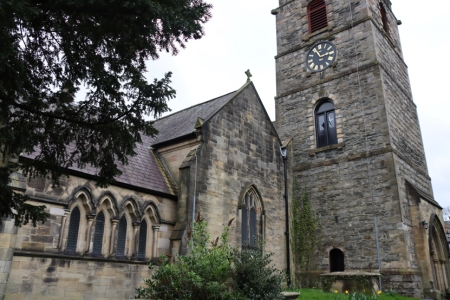 The Chester Archaeological Society 2024 season of excursions started excellently today with the CAS visit to the Church of St Collen, who gave his name to Llangollen. It is the only church in Wales to have taken the saint’s name. Like most Medieval churches in Wales, St Collen’s has undergone considerable alterations, including an 18thcentury tower and a 19th century chancel, vestry and south nave, but there are some very fine 13th century features to be seen, in the Perpendicular Gothic style, including an impressive shrine canopy and mason’s marks. There are also intriguing signs that a Lady Chapel was once incorporated into north aisle. The most remarkable feature of the church is a really superb hammerbeam roof bedecked with ornamental sculptures, both religious and secular, from the early 16th century.
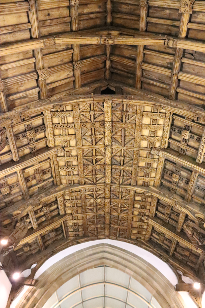 Today, to ensure the survival of the church as a living and breathing community asset, it is undergoing extensive but very sympathetic re-forming. Suzanne Evans is the Project Manager of this massive task, and was our superb guide today. Suzanne described how the reinvented church will be fully inclusive, not only of the existing congregation who are much-attached to the church, but of the wider community as well, taking into account the needs of those currently unable to make the most of what St Collen’s has to offer. At the same time, the exciting opportunity will be taken to investigate as much of the church’s architectural and funerary history as possible, adding to the community’s understanding of this important contributor to the town’s impressive ecclesiastical heritage.
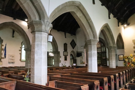 After a very welcome cup of tea, there was a round of applause as we thanked both Suzanne for being our terrific guide and Pauline for making all the arrangements. It was great to meet some of the other CAS members, and to hear all the questions and observations. There was a lot of information sharing, which is exactly what one expects of CAS members. What a great start to the year’s excursions! Many thanks again Suzanne and Pauline.
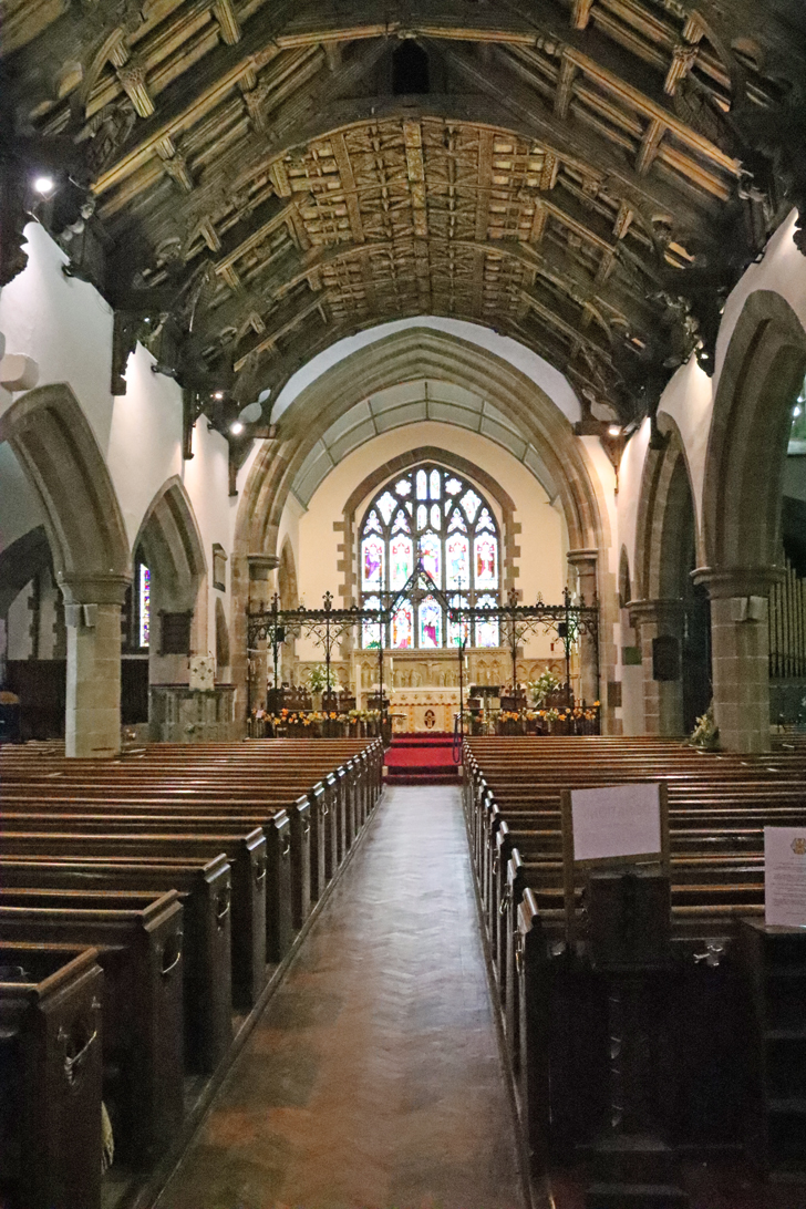
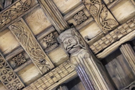
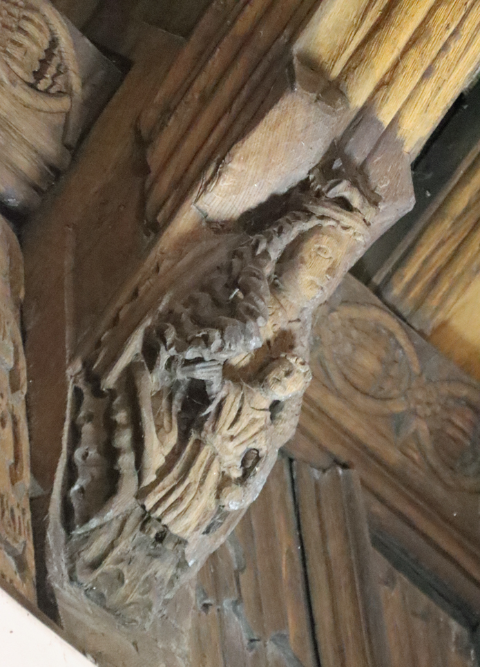
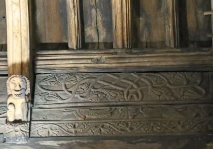
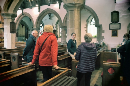
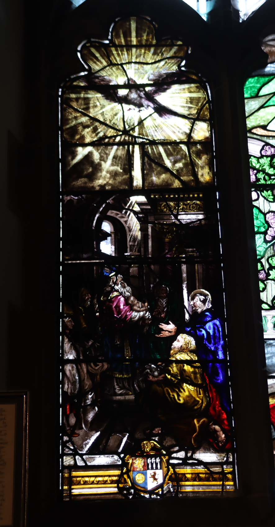
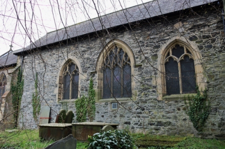


