Category Archives: Scenery

A stroll through Marford Quarry (source of the Mersey Tunnel cement) on a cold but sunny day

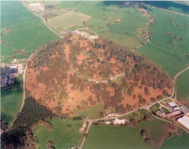
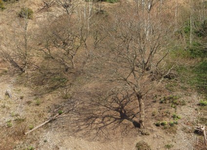
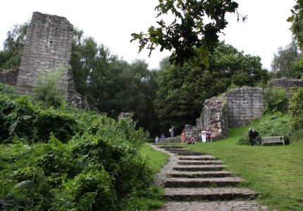
Last week we went to Marford Quarry, just off the Chester-Wrexham road just south of Rossett.  I had never visited before, but it has been open to the public for walking and cycling for decades and has had a lot of work invested in it to make it a great place to walk dogs and stretch legs.  Bigger and smaller footpaths and trails make for a lot of variation, as do the multiple facets of the quarry and its surroundings, with different types of plantation and wildlife providing a lot to see.  Some of it looked almost like a desert landscape, whilst other parts were thick with shrubs and trees.  Although trees dominate even the sparsely covered areas, particularly silver birch and conifers, and the bird song is fabulous, there is a lot more going on at ground level, with wild flowers clustering in favoured spots and the rustle of birds turning over the leaves.  We saw a wren, long-tailed tits, blue tits, great tits, blackbirds and plenty of robins bouncing fearlessly near the paths.  The heart of the quarry a deep bowl with a slight rise in the centre with a single tree on top, is a dramatic sight, like an enormous amphitheatre.

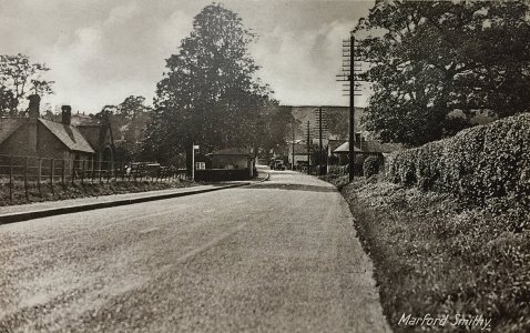
Marford smithy on the left, with the glacial moraine like a giant wall in the background, now quarried away. Source: Essentials Magazine https://www.essentialsmag.co.uk/features/the-last-icesheet

Marford Hill, climbing from Rossett towards Wrexham, is what remains of a glacial moraine.  An article, The Last Ice Sheet by Pam Gibbons in Essentials magazine, has a photograph of the quarry before it began to be quarried for sand and gravel to make cement.  It is shown right, around 130ft high and up to 25,000 years old, dumped by the glacier as it melted, and the ice retreated north.  The former smithy, used by ATS for so long, and recently replaced by two modern houses, is clearly visible on the left at the foot of the hill.  A marvellous photograph, with thanks to Pam Gibbons for recognizing its significance when she saw it.

There was originally a motte and bailey castle at the top of Marford, called Rofft.  I’ll see what I can find out about it, but the quarrying destroyed it, which surprises me given how aware people were of the value of historical sites by the 1930s.  It is such a shame.

Here’s the original caption from the Wonders of World Engineering website: “BUILDING THE ROADWAY through the Mersey Tunnel. Made of reinforced concrete, the roadway is supported by two intermediate walls, 12 inches thick and 21 feet apart, and is anchored to the cast-iron lining. The finished road in the main tunnel has a width of 36 feet between the kerbs. The tunnel has a capacity of 4,150 vehicles an hour, with cars 100 feet apart and moving at twenty miles an hour. The space beneath the roadway acts as the duct for fresh air and is sufficiently large to provide a second road or railway should they be necessary.” Source: Wonders of World Engineering

The quarry opened in 1927 and closed in 1971.  Its biggest claim to fame is the it supplied material for the Mersey Tunnel.  The Mersey Ferry and the railway tunnel, between them doing a good job of carrying passengers to and fro, could not cope with the growing demands of road traffic.  Initially a bridge was proposed, but the engineering wisdom came down in favour of a tunnel, which required a lot of aggregate.  Work on the tunnel started on December 19th 1925.  Today, the former Birkenhead to Wrexham railway, following the river valley, still runs between Chester and Wrexham and runs immediately to the west of Marford Quarry, with the A483 bypass now running between them.  The railway enabled the quarried materials to be loaded directly on to the train and carried to Birkenhead, a super-efficient and cost effective way of acquiring the building materials for the tunnel project.  For a good article on the building of the Mersey Tunnel, with some great pictures, see the Wonders of World Engineering website, which gives the following details “On July 18, 1934, the Mersey Tunnel was opened to traffic by His Majesty King George V. The main tunnel has a length of 3,751 yards, from the Old Haymarket, Liverpool, to King’s Square, Birkenhead. The branch tunnels which lead to the docks on either side of the river bring the total length of roadway to 5,064 yards, or nearly three miles.”  Funny to think of Marford’s glacial moraine holding it all together.  For more about the history of the quarry and its ownership, see the Maes y Pant website.

The main bowl of the quarry, a single tree standing on a slight rise, the rest of the quarry edges rising like an amphitheatre all around it. When I first rounded a corner and saw it, completely empty of people, I found it distinctly eerie.

The 39 acre site was designated a Site of Special Scientific Interest in 1989 and the following year 26 acres of it were bought by the North Wales Wildlife Trust.  As the North Wales Wildlife Trust puts it “The reserve is especially important for a specialised group of invertebrates, aculeate Hymenoptera (bees, ants and wasps), with an astounding 171 different species recorded (2018). Ants, in particular, are an important source of food for green woodpeckers.” In 2011 the site was split into two, and one section of the site is now owned by the Maes-y–Pant Action Group Ltd.

Sadly, the photos taken with the emergency back-up camera that I carry in my handbag did not come out as well as I hoped, but hopefully give some sense of what is there to be seen.  There was a bit that we missed, where there is apparently a viewing point and an outdoor gym, but we figured out where they were so will visit them next time.


Visiting:
There were all age groups present, and several of the unwilling-leg variety who were doing very nicely on the nicely maintained paths, making good use of plenty of benches dotted around (and lots of fallen logs to sit on).  There are some gradients, but not many severe ones, and it is very easy to avoid them.

There are two places to park, one on Springfield Lane just below the Trevor Arms in Marford, with spaces on the side of the road, and a small but proper car park on Pant Lane just beyond (heading north) the Co-op at the top of the hill.  We parked in Springfield Lane and walked along the quarry footpaths to Grove Street, and I walked back to retrieve the car to collect Dad.  It’s about a 15 minute fast walk from one to the other.

Sources

Gibbon, P. The Last Ice Age.  Essentials Magazine
https://www.essentialsmag.co.uk/features/the-last-icesheet

Maes y Pant
Site History by Trevor Britton
http://maes-y-pant.com/site-history.html

Marford Conservation Area Assessment and Management Plan
https://coflein.gov.uk/media/305/417/640273.pdf

Twentieth Century Society
Of the Month: Building of the month – October 2006 – The Mersey Tunnel
https://c20society.org.uk/building-of-the-month/the-mersey-tunnel

Wonders of World Engineering
The Mersey Tunnel
https://wondersofworldengineering.com/merseytunnel.html


A visit to Chirk Castle yesterday for the snowdrops and daffodils

It was such a gloriously sunny day yesterday that even though I had marked today for giving the house a much-need top-to-toe clean, I abandoned the whole project, jumped in the car, and  stopped off to pick up my Dad before driving down to Chirk Castle to enjoy the pristine garden and the walks in the small woodland.  It is a great time of year for it.  The castle, the only one of Edward I’s Marcher fortresses still inhabited today, always a little intimidating in its block-like immobility, is far less bellicose in the bright sun.

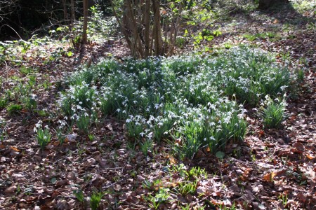
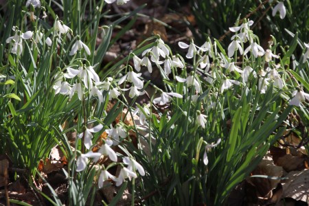
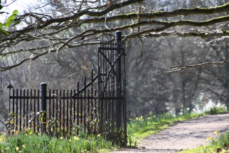
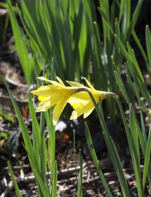
The topiary is great at any time of year, and the colours of new foliage and bright heather give a real lift to everything, whilst the daffodils and snowdrops, popping up everywhere but particularly good in the woodland, are a joy.  The snowdrops are all in full swing, but although a lot of daffodils are out and looking terrific, there are still more to break out of their buds.  We stopped off on a perfectly placed bench for a blissful half hour in the sun to look out beyond the ha-ha over the rolling hillside towards the view below.  It’s only a short outing, but a very agreeable one.   I’ll let the pictures speak for themselves.


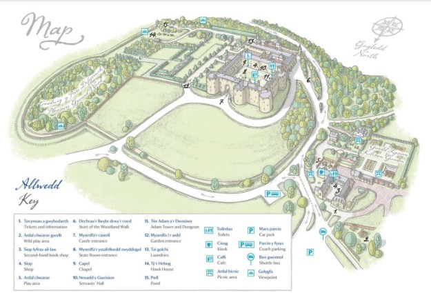
Plan of Chirk Castle grounds. Most of the snowdrops are in the Pleasure Ground Wood, but the daffodils are everywhere.  Source:  Chirk Castle, National Trust (website and free leaflet available in the ticket office)

Details of visiting are on the Chirk Castle website (National Trust).  Regarding my usual comment on access, a wheelchair user might be able to see some of the gardens, but the woodland is probably not advisable.  As for unwilling legs, yes if you keep in mind that the ground is uneven.  There is a shuttle from the car park to the castle entrance, as the walk up can be challenging for unwilling legs.


Beeston Crag Prehistory #1 – The Earlier Prehistory

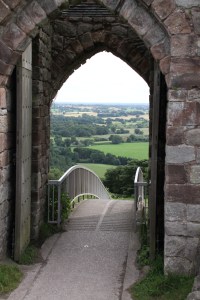
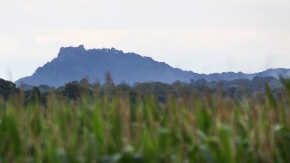
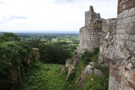
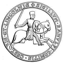
Beeston crag is a superb landmark, a small outcrop of the Cheshire Sandstone Ridge that was first occupied by people during the post-glacial period. Today, Beeston crag’s main claim to fame is the ruined 13th Century castle of Ranulf III, 6th Earl of Chester, built to intimidate his enemies, impress his allies, and provide himself with a magnificent legacy.  Following the Ranulf III’s death in 1232 and the subsequent death of his heir in 1235, the castle was repaired and rebuilt on several occasions until the 17th century when it was deliberately destroyed.  After this, the romance of the ruins attracted artists and tourist alike.  Today it is managed by English Heritage and is an engaging visitor attraction.  This has all been covered on two previous posts. Ranulf III’s Beeston Castle Part 1 looks at the remarkable magnate Ranulf III;  Ranulf III’s Beeston Castle Part 2 describes the castle’s history and includes notes about visiting.
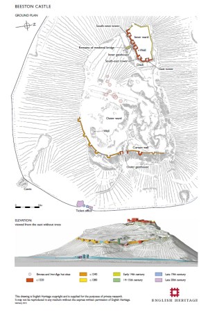
Beeston Castle, showing the excavated Bronze Age and Iron Age posthole locations, marking hut circles in the outer ward (pink circles).  The outer ward fortifications followed some of the lines of the Iron Age defences and the earlier Bronze Age banks.  Both contemporary and earlier prehistoric sites were also found in other parts of the site.  Source: Liddiard and Swallow 2007

Hidden beneath all of this rich Medieval and Civil War history is the archaeological story of the crag before history began.  The  impressive Medieval fortifications incorporate the remains of an invisible but remarkable prehistoric past, making the same use of a formidable location  that dominates the Cheshire plain, with clear views to the north, east and west, providing safety from predatory animals in what was dense woodland below.  Archaeologists between the 1960s and 1980s excavated these remains of the area’s prehistoric activity, some of it very exciting.

Although the Cheshire Sandstone Ridge as a whole is rich in prehistoric sites, in these two posts I simply want to get to grips with some of this particular crag’s prehistoric past.  I have divided Beeston’s prehistory into a post about the earlier  prehistory (in this part, part 1) and the later prehistory (in part 2).  Other sites on the ridge will be mentioned in passing, and future posts will discuss what all of the research on the Cheshire Sandstone Ridge contributes to our knowledge of prehistory in Cheshire.

For anyone wanting to find out more about each of the periods of British prehistory mentioned, some excellent books are listed in the Sources at the end of each of the two posts.

This post has been divided into the following sections:

  • Survey and excavation history
  • A note on the Three Age system
  • The role of the geology, geography and environment
  • The archaeological sequence at Beeston
  • Raw material acquisition at early prehistoric Beeston
  • Final comments
  • Next
  • Sources

Survey and excavation history

Aerial view over Beeston crag showing its prominent position over the landscape. Source: Sandstone Ridge Trust

Some of the hillforts on the Cheshire Sandstone Ridge were excavated in the mid-1930s by William Varley, an archaeologist with the University of Liverpool.  His excavations were focused on  hillforts, and although there were some inconsistencies is his approach, and his interpretations are sometimes questioned, he established that there was information under the ground along the ridge, and that it was worth investigating further.  Varley bypassed Beeston, but thirty years later new excavations filled this gap, focusing on both prehistoric and Mediaeval remains, a suitable endorsement of Varley’s initial exploratory work.
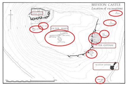
In the excavations of the 1960s-80s there were two main concentrations of excavation, one in the centre of the outer ward, and another by the outer gateway. Another fairly large area was opened to the south of the outer gateway, and some small cuttings were opened in other areas. Source: Ellis 1993 (with red circles added)

Two closely connected stretches of investigation are responsible for our understanding of the prehistory of the Beeston.  These are Laurence Keen’s work between 1968 and 1973 and Peter Hough’s work between 1975 and 1985.  These excavations found evidence of early as well as later prehistory, and made use of radiocarbon dating to establish a sound chronological sequence.    The account on this blog post makes extensive use of those excavations, reported in Beeston Castle, Cheshire. Excavations by Laurence Keen and Peter Hough, 1968-1985 edited by Peter Ellis and published by  English Heritage in 1993. Unfortunately, many of the tables and images were on microfiche, and although the core text is now available for download, the microfiches have presumably not been digitized.
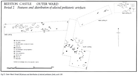
Plan of the Outer Ward excavation findings. Source: Ellis 1993

Although a lot of interpretive schemes in archaeology extrapolate from very small samples of big sites, particularly hillforts, in the case of the Keen and Hough excavations, there were two reasonably large areas where the work was concentrated, a smaller but still significant trench and several useful cuttings to sample other areas within the locale.  It is by no means straightforward to collate all this information into a coherent narrative, even if that is actually desirable with this sort of sampling, but some very useful findings were reported.

Some of the results of one of the sub-surface surveys in 2010. Source:  an unpublished report, via Garner 2016.

No recent excavation has taken place at Beeston, but a series of geophysical and LiDAR (Light Detection and Ranging) surveys were carried out by the Habitats and Hillforts Project in 2009 and 2010, at the outer ward and outer gateway.  Although these produced no definitive results, they did identify some anomalies that could indicate where future excavation projects might concentrate their attentions.  Much of the Habitats and Hillforts work has been published.  Dan Garner’s 2012 short introductory booklet  Hillforts of the Cheshire Sandstone Ridge, which looks at multiple periods of occupation, is very useful for becoming acquainted with the Cheshire Ridge archaeology.  Garner’s 2016 academic volume Hillforts of the Cheshire  Ridge is of considerable value for understanding both previous and current survey and excavation works at the other Cheshire Sandston Ridge sites in greater detail, particularly Eddisbury Hillfort.

A note on the Three-Age system
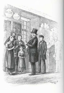
Thomsen explaining the Three-age System in Copenhagen, 1846. Drawing by Magnus Petersen, Thomsen’s illustrator. Source: Wikipedia

The 19th Century vision of a Three Age System, (Stone Age, Bronze Age and Iron Age), devised by Danish antiquarian Christian Jürgensen Thomsen and published in 1836,  was a spirited attempt to create a chronological framework for Danish prehistory that was widely adopted.  It became associated with the idea that technological innovations were inextricably linked to human progress and, by extension, the superiority of industrial nations.

Although ideas have now changed, the Three Age system is still the main organizing framework within which prehistory is discussed.  Having noted that the early Neolithic (New Stone Age) is an extension of the Mesolithic (Middle Stone Age), that the later Neolithic segues into the Early Bronze Age, as does the later Bronze Age into the early Iron Age, it is possible to move on.  These issues are all dealt with comprehensively in the academic literature.  The Three Age model still provides a framework within which most prehistoric archaeology is bashed out and bullied into shape, and as long as its limitations are kept to the fore, it need not be a wholly unyielding strait-jacket.

The role of geology, geography and environment
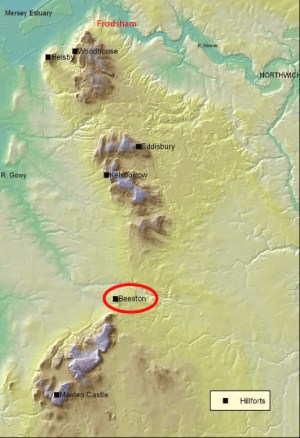
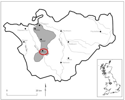
The location of Beeston within the Cheshire Sandston Ridge. Source: Garner 2012 (with red ring added)

Beeston is part of the fabulous Cheshire Sandstone Ridge, and those who selected it as an ideal place to settle, either temporarily or in the long-term, were presumably attracted by its height 150m above sea level, its location in a vast area of mixed deciduous woodland and, eventually, its defensive potential.

From a distance this prominent piece of geology looks like a complete anomaly, rising like a fossilized dinosaur’s spine out of the Cheshire Sandstone Ridge, knobbly and incomplete, but obviously the product of the same geological engine, the rocky components of the same machine.  Beeston sits towards the southern end of the ridge.  The Cheshire plain spreads from its base in all directions, the hills of the Welsh foothills to the west and the Peak district to the northeast, visible only in the far distance.  The Cheshire Sandstone Ridge is made up of desert sands and pebbles up to 225 million years old.  Questions about how the ridge formed and why it looks as it does are going to have to be the subject of a future post, written by someone else, but its upstanding presence in the otherwise flat landscape tell us, on its own, something about the prehistoric communities that, on and off over a period of nearly 8000 years, decided that it was a good place in which to camp or settle.
Archaeologically speaking, the sandstone composition is interesting because sandstone does not contain any of the stone types used used for the manufacture of stone tools.  This means that the flint and chert used for such tools was brought here from somewhere else.  This suggests not only that people were here for something other than the raw materials for tool manufacture but that they had to bring either the stone for tool manufacture with them, or the tools themselves.
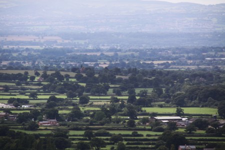
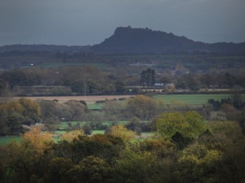
View from Beeston crag today west towards the Welsh foothills. In the Mesolithic and early Neolithic this would have been dense woodland. Clearance on the plain started in the later Neolithic but probably did not make significant changes to the patterns of vegetation until the mid Bronze Age to early Iron Age.

What the Cheshire Ridge has in abundance, other than sandstone, is height.  This provides truly impressive visibility across the landscape, as well as respite from the dense woodland below.  Whether or not the views across the plain would have been much use in earlier prehistoric phases is debateable, as the dense woodland would have disguised the approach of any but the largest groups of people.  Even after extensive woodland clearance had carved out agricultural fields,  this might have remained true.  On the other hand, lines of sight to other communities on other parts of the ridge might have been important, and clear views of weather fronts could also have been value.  Respite from dense woodland may have been relevant, especially when brown bear and wolves stalked the plains in hunt of meat of any description.  The best way to avoid becoming something else’s dinner is always to remove oneself from its preferred habitat.  It’s not a fool-proof strategy, but it’s certainly a step in the right direction.
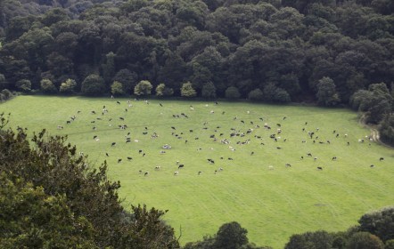
Cattle grazing in a field below Beeston.

According to the Sandstone Ridge Trust, farming remains the major land use, with livestock farming dominating the area.  This is interesting, as it tends to confirm the general impression that the damp clays of the Cheshire plain would have been difficult to cultivate in the past, particularly in early prehistory when the environment was much wetter and the area around the ridge included a network of freshwater springs.  Woodland cover today exceeds 13%, which is high compared to nearby areas, but low compared to the probable coverage throughout most of prehistory.

A multi-period location
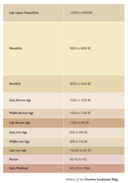
Archaeological chronology of the Cheshire Sandstone Ridge. Source: Garner 2012

Wherever there is a medieval castle perched on a hilltop, it is worth looking for an Iron  Age hillfort.  They are often there to be found.  It is also worth looking even further down the chronological funnel because some of the fortified prehistoric hilltops once synonymous with the Iron Age, are now known to have been built centuries before the Iron Age began.  So wherever there is an Iron Age hillfort, it is worth bearing in mind that there may be a late Bronze Age predecessor, as was the case at Beeston.   At Beeston the two phases of Iron Age hillfort were preceded by two phases of later Bronze Age settlement, one of which included an enclosing bank, and these were themselves preceded by even earlier prehistory – the Mesolithic, Neolithic and Early Bronze Age.

On the basis of previous work in the area, the excavators may have been hoping for prehistoric as well as Medieval finds, and they found evidence from the Mesolithic occupation from around 8000BC, dotted around all the way to the Romano-British period, which in Cheshire dates to c.70AD.  These were small outposts of earlier prehistoric activity Mesolithic (Middle Stone Age), Neolithic (New Stone Age) and Early Bronze Age, as well as more comprehensive discoveries of the later Bronze Age and Iron Age.  The earlier prehistoric phases will all be discussed below and the later prehistoric in Part 2.  Although there were discontinuities between the various occupations of Beeston, the crag was clearly of value to people of very different economic and social profiles over a very long period of time.
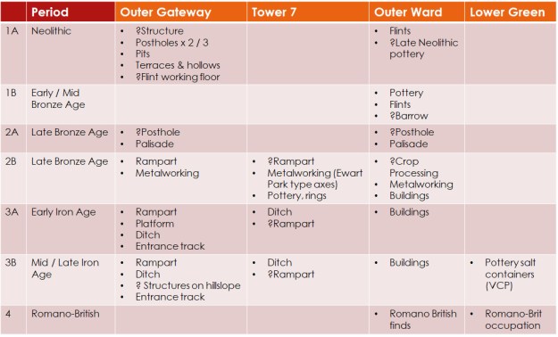
Archaeological periods at Beeston crag. Collated from Ellis 1993.

The Archaeological Sequence at Beeston

After the Ice Age, 9000-4000BC
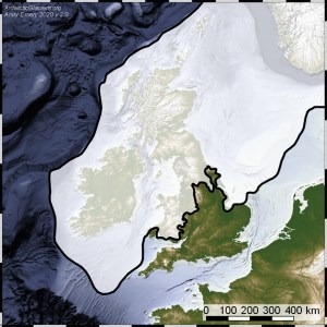
Maximum extent of the Devensian ice-sheet. Much of the rest of southern England will have been encased in permafrost which only began to melt as the ice sheets retreated, starting at around 10,000BC. Source: Antarctic Glaciers

During the last Ice Age, the Devensian, glacial ice-sheets extended in an uneven line towards southern England, covering Wales and Ireland.  The ice sheets carved out the u-shaped valleys that we all remember from school geography lessons, transporting huge amounts of debris from north to south, dropping thick deposits of soil and gravel, and creating meltwater channels.  Vegetation was demolished either by the ice or by the temperatures, animals and people departed, and most of Britain was empty of life.  Connected to the continent by a substantial land bridge, Britain only began to revive when the climate started to warm, and the ice began to melt.  Vegetation, consisting of  deciduous woodlands, shrubs and grasslands slowly returned to the lowlands, followed across the land-bridge by, amongst others, red deer, wild cattle (aurochs), reindeer, elk, brown bear, wolf and lynx.  In their wake followed small communities of people who lived by hunting game, foraging for wild vegetables, roots, seeds, herbs and fruit, and fishing on the coast and in rivers.  Today the period during which these groups of people returned and occupied post-glacial Britain is known as the Mesolithic, or Middle Stone Age. As the ice continued to melt and sea levels continued to rise, Britain was eventually physically cut off from the mainland, but that did not prevent other types of connection being established.
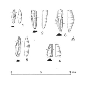
Mesolithic tools found from Beeston Castle, all less than 5cm long. Source: Ellis 1993

The Beeston Mesolithic finds are restricted to a small handful of stone tools that had been dislodged from their original context.  These are very typical of the period, consisting of microliths (tiny stone tools), and other very small pieces.  They do not say much on their own, but other Mesolithic sites in the area argue that the Beeston finds are a very small part of a much bigger Mesolithic story in the area.  In particular, Harrol Edge near Frodsham produced over 1500 tools from the period and will be discussed further below.  Other small sites are dotted along the Cheshire Ridge although most are as ephemeral as those at Beeston.  These include an earlier and later Mesolithic phase at Carden Park near Broxton; Riley Bank Farm, Alvanley Cliff (all at the northern outcrop); and Seven Lows on the east edge of the central outcrop (a Late Neolithic/Early Bronze Age site where around 100 pieces of worked flint were found).  These are all surface scatters, not clearly defined and stratified sites, but they are valuable for indicating the presence of people at this time, suggesting the size of  individual occupations and the period of time over which visits were made.  Together, they argue for small, temporary stopping off points as the landscape was exploited for food, craft and tool manufacturing resources.  They combine with other evidence to give an impression of a very busy pattern of landscape use in the Cheshire Ridge area, probably on a seasonal basis.

The Neolithic, 4000-2500BC

The later Mesolithic did not come to an abrupt end, any more than the Neolithic began as a rocket launch.  The long period of transition between the two livelihood strategies were influenced by processes taking place on the continent, themselves innovated in the Near East.  These presented opportunities and options, perhaps attractive to some and not to others, and take-up was no overnight phenomenon.
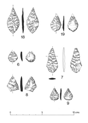
Neolithic stone tools from Beeston crag.  Numbers 18 and 19 at the top of the image are earlier Neolithic leaf-shaped arrowheads. Source:  Ellis 1993.

The changes that help to define the Neolithic (New Stone Age), when they began to gather momentum in around the third millennium BC, were characterized by a number of transformations that took place over the following 2500 years.  The spread of the main features generally characterizing the Neolithic did not spread at the same rate throughout Britain, and not all characteristics were adopted at the same time, even in neighbouring areas.  The main components defining the Neolithic are new forms of technology, a change of food acquisition practices, accompanied by new types of social statements.  Continuities and discontinuities between the Mesolithic and Neolithic are eternally under debate, because they are central to the question of how the domesticated crops and livestock, stone tool technology and more nebulous spiritual ideas were introduced from the continent, adopted in Britain and then spread.  Whatever the mechanism of their arrival in Britain, they became cornerstones of everyday life, and eventually found throughout Britain and Ireland, taking different forms in different areas, but based on a similar package livelihood opportunities, both economic and conceptual.

Early Neolithic of the Grimston/carinated tradition in northern Britain. Source: Malone 2001.

In parts of Britain, the Neolithic represents the first foray into mixed agriculture, with domesticated cereal crops and livestock and the adoption of pottery, which helped to introduce new cooking techniques, and to increase the variety of foodstuffs that could be consumed.  It also improved storage of both solids and liquids, protecting them from insect and vermin, and  took on cultural as well as economic roles. It is possible that after an initial foray into cereal production, pastoralism became the dominant approach to Neolithic food production.  This was probably particularly true in areas like Cheshire, where the clays, meres, mosses and heathlands would have been anything other than ideal for crop cultivation, and where dairy and other livestock farming dominate today.

As people began to manage their livelihoods in new ways, novel ceremonial and funerary monuments were built, and pottery and stone tools began to enter the realm of the dead as well as the living.  Long distance relationships, already a feature of some Mesolithic communities, extended, as the trade in axes and exotic materials expanded.
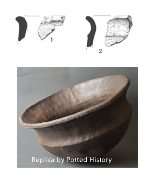
Grimston Ware sherds from Beeston (Royle and Woodward in Ellis 1993). The lovely replica showing what a complete carinated Grimston bowl would look like, is by Potted History

Information about the Neolithic in Cheshire, and particularly the Cheshire Ridge, is at best fragmentary, and it is not yet possible to pull together a coherent narrative of what is happening.  As with the Mesolithic, settlement data, rarely in the form of structural remains and usually in the form of  secondary scatters of objects on the surface, are generally small and dispersed but together contribute to  distribution maps to indicate, at the very least, where Neolithic people were present, and what form their presence took.  

At Beeston, objects of both the earlier and mid Neolithic were placed by Ellis in his 1A phase.  Objects diagnostic of the earlier Neolithic include leaf-shaped arrowheads (above), and carinated bowls (right) that used to be referred to as Grimston or Grimston-Lyles Hill ware, generally in circulation from c.3750BC.  The carination here is the rim that circles the centre of the vessel, and in general refers to a vessel’s wall making a sharp change of direction.  At Beeston both leaf-shaped arrowheads and sherds of carinated bowl are present, although the pottery is very fragmentary.  Because clay was fired at relatively low temperatures, and because temper in the fabric was often organic or composed of stone pieces, the pots were relatively fragile and once abandoned, were vulnerable to frost and heat damage and to erosive forces.  It is therefore comparatively rare to find Neolithic pottery found in tact.  Although Grimston carinated wares continued to be used for hundreds of years in some areas, in most they were replaced by more regionally distinct styles. 

The leaf-shaped arrowheads that were spread widely through Britain had no antecedents in the Mesolithic, they suggest that hunting still formed part of subsistence activities.  The hand-made (as opposed to wheel-thrown) carinated pottery.  Carinated bowls were found in a wide range of contexts in Britain, from pits and middens to early burial contexts, but there is no evidence of burial sites of this date either at Beeston or nearby.
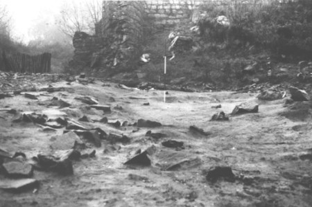
The early to mid Neolithic phase at Beeston’s outer entrance under excavation. You can see the stone walls of the Medieval castle in the background. This area is at the entrance to the outer ward, so when you pause to walk through the gap in the walls, remember that a Neolithic site was found underfoot. Source: Ellis 1993.

Another area of Neolithic at occupation at Beeston was found during the excavation at the outer gateway to the Medieval castle.  The Neolithic phase in this area was marked by terraces, hollows, pits and postholes.  There had clearly been an attempt to provide a level surface, implying some investment in the site, suggesting either the intention to stay put for some time, make repeat visits annually, or return at seasonally.  As well as this evidence of settlement, there were stone tools including small axe heads and the sherds of four types of Neolithic pottery, spanning the early to mid Neolithic. 

Additional Neolithic material was found on the plateau edge.  A deep pit cut into the bedrock and a smaller pit or posthole were accompanied by a single early-mid Neolithic sherd, at the base of the deep it.  It is difficult to assess, but the excavators suggest that it may mark a former entrance.  Finally, a single Late Neolithic sherd was found in Post-Medieval layers in the outer ward, where the Bronze Age and Iron Age hut circles were found.

Were these Neolithic occupants permanent cultivators who carved out fields in the woodland below, peripatetic livestock herders, or occasional visitors making use of the outcrop as a supplement to activities on the plain or elsewhere?  There are no plant or animal remains surviving to give us a hint.  The evidence from pollen analysis indicates that post-glacial Beeston developed in the context of mixed oak woodland and Ellis says that pollen data from north of Beeston suggests an initial clearance phase, but that this did not happen until the third millennium (i.e. between 3000BC and 2000BC, in the later Neolithic).   At Eddisbury hillfort, excavations in 2010 produced wood charcoal and other vegetation remains that suggest heath or moorland conditions that are generally associated with human manipulation of the landscape, in particular livestock grazing.  It is possible that the ridge outcrops were being used for seasonal upland herding activities.  Patches of grassland would have been ideal for grazing sheep, and coarse shrub for browsing goat, whilst cool woodland on the plain, particularly oak with its acorns, would have suited pigs perfectly.

Neolithic worked tools from Beeston Castle. Source: Liddiard and Swallow 2007

There are other explanations possible as well.  The small size of the assemblages may suggest scouting parties or small detachments engaged in resource aquisition tasks, heading east to west or north to south, and heading up hill for safety en route somewhere else.

All of the above is pure speculation, based on livelihoods practiced elsewhere, but it is the sort of speculation that ensures that when new data emerges, different models of occupation can be tested against the cumulative findings.

Although ceremonial and burial monuments are characteristic of some regions, nothing of this sort on the ridge or, to date, in the immediate landscape have been found in the early/mid Neolithic. Not until right at the end of the Neolithic and the beginning of the Early Bronze Age, when round barrows begin to appear on the sandstone ridge, and beaker remains were found at Beeston.  This is at least 2000 years after the leaf-shaped arrowheads that we looked at above.  I’ve covered beakers and round barrows in the Early Bronze Age section below, although they might just as well be termed Late or Final Neolithic.

Although only a small area of Neolithic land modification was identified, and there are only a handful of artefacts, it is worth remembering that only a small part of the entire crag was sampled.  That’s not anyone’s fault, because it would take decades to dig up the entire thing.  The excavation sample was actually impressive, and it does mean that there may well be other examples Neolithic land modification and objects to discover both on Beeston and other outcrops, as well as in the surrounding landscape.  Although it’s a trite analogy, every new site, however small, is an important part of the Neolithic jigsaw, not only allowing insights locally, but contributing to how we understand differences from and linkages between geographical areas in Britain.  Fortunately, excavation programmes are ongoing under Habitats and Hillforts Project and as all of this Cheshire Sandstone Ridge data is collated, it will hopefully provide an increasingly coherent understanding of Neolithic livelihoods on parts of the ridge and the surrounding area.

Early Bronze Age / Beaker period c.2500-1700BC
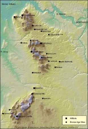
Earlier and Later Bronze Age sites along the Cheshire Ridge. Source: Garner 2012

In most parts of the country there is no clear delineation between the Late Neolithic and earliest version of the Bronze Age, sometimes referred to as the Copper Age or chalcolithic (roughly, the copper stone age) because copper appeared before bronze was introduced.  A new type of pottery, the Beaker, is also characteristic of this cross-over period, together with a range of associated objects.

It has been clear to archaeologists for a long time that the Beaker tradition was communicated to Britain and Ireland from the continent, where its geographical presence was widespread, found in Netherlands, Belgium, Germany, France, Italy, and the Iberian peninsula.  A  multi-disciplinary DNA analysis research project in 2017 proposed that a significant percentage of the indigenous population of Britain was, by the Middle Bronze Age, replaced by those who brought the Beaker tradition with them at the end of the Neolithic. Here’s an excerpt from the report (Olalde et al 2017).

The arrival of the Beaker Complex precipitated a profound demographic transformation in Britain, exemplified by the absence of individuals in our dataset without large amounts of Steppe-related ancestry after 2400 BCE. It is possible that the uneven geographic distribution of our samples, coupled with different burial practises between local and incoming populations (cremation versus burial) during the early stages of interaction could result in a sampling bias against local individuals. However, the signal observed during the Beaker period persisted through the later Bronze Age, without any evidence of genetically Neolithic-like individuals among the 27 Bronze Age individuals we newly report, who traced more than 90% of their ancestry to individuals of the central European Beaker Complex. Thus, the genetic evidence points to a substantial amount of migration into Britain from the European mainland beginning around 2400 BCE.

Cheshire’s only complete beaker, from Gawsworth. Source: Megalithic.co.uk

As is so often the case with this sort of DNA research, as highlighted in the study itself, there are questions remaining about the extent to which it is possible to extrapolate from the data used, including sampling issues (statistical, geographical and relating to the quality of the material).  However, although the question about how and why the continental Beaker objects and ideas became so popular remains open to some extent, it seems probable that as well as cultural dispersal of ideas and practices, some level of migration took place.  However it happened, at the end of the Neolithic the continental Beaker and associated objects did become desirable, and were found extensively under round barrows, as well as occasionally in other contexts, in many parts of Britain.  The cultivation of cereals also appears to have been resumed in some areas and intensified in others at this time, with new roundhouses being built in domestic contexts.

Distribution of some of the round barrows in Cheshire. Source: Morgan and Morgan 2004.

Beakers are not as common in northwest England as they were in the south, and only one complete Beaker, a long-necked type, has been found in Cheshire, in a round barrow burial Gawsworth, which is in the far east of the county, near Macclesfield.  The Beeston Beaker-related finds fall within Ellis’s 1B phase.   They were found at the Outer Gateway and in the Outer Ward.  In all cases they were found in amongst later material, within later prehistoric and Medieval material and postholes.  They consist of Beaker fragment, collared urn and/or pygmy cup fragments, a barbed and tanged arrowhead and four knife blades.  In Ellis’s collation of the excavations by Keen and Hough, the pottery analysis by Royle and Woodward interpreted the Beeston Beaker and its associated finds, as evidence for a vanished barrow burial.  There has been extensive use of the outer wards since prehistoric times with considerable quarrying and levelling on all areas of the plateau, so it is not impossible that a round barrow had been built and later destroyed. Beakers could, however, also be found as broken sherds in isolated pits, as well as in domestic contexts.  Other new forms of pottery followed in the Early Bronze Age, including food vessels, cordoned urns, collared urns and pygmy/accessory cups, of which a number of examples have been found along the Cheshire Ridge.
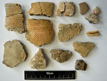
Seven Lows assemblage with Beaker sherds. British Museum 1862,0707.64. Source: British Museum

Round barrows with Early Bronze Age finds in them have been found in the Cheshire Ridge area.  Examples shown on the map above are Carden Park at Broxton, Castle Cob, Glead Hill Cob, Peckforton, High Billinge, Little Budworth and the Seven Lows barrow cemetery.  Few have been excavated in modern times, but most were cremations.  Only Clead Hill produced metal, in the form of a single bronze pin.  It was accompanied by two barbed and tanged arrowheads, collared urns and a pygmy/accessory cup, all consistent with Early Bronze Age burial assemblages.  The most common form of metal dating to the Early Bronze Age in the area was in the form of isolated finds of flat axe heads, but there are only four of those in the general vicinity.  The recent excavation report for Seven Lows has just been reported (it arrived through my letterbox yesterday) by Dan Garner in the Journal of the Chester Archaeological Society, so there will more on that site on a future post.

There is even less information for the Beaker-related presence at Beeston than the Neolithic, but what has been found is not inconsistent with other finds in the area, and it is to be hoped that further excavation will lead to a more complete understanding of the Beaker tradition in the Cheshire Ridge area.


Raw material acquisition at early prehistoric Beeston

Sourcing stone

Flint and chert were the materials used by the tool makers who left their tools at Beeston Crag.  Because of the way in which the stone fractures predictably when hit by a hard or soft object, flint and chert are favoured for flaked stone tool manufacture.  A remarkable amount of precision is achieved, meaning that multiple classes of foot types can be manufactured which, once identified by archaeologists, can be categorized and can contribute to an understanding of livelihood transformation and regional differentiation.

Mesolithic flint and chert tools from the Adams collection, collected at Harrol Edge, Frodsham. Source: Brooks, in Garner 2016

The sandstone ridge was not the source of the raw materials used in the earlier prehistoric period for stone tool manufacture.  At  Harrol Edge, near Woodhouse Hill at Frodsham, over 1500 pieces of Mesolithic worked stone pieces were gathered during unofficial fieldwalking in the 1950s by local resident J. Adams, since donated to the Grosvenor Museum in Chester.

For the flint, an analysis of the Harrol Edge tools by Ian Brooks identifies two sources, in chalk deposits of the Lincolnshire/Yorkshire wolds or Northern Ireland.  This does not necessarily mean that people had to go to either place or engage in trade to source the stone, because the ice-sheets transported considerable amounts of stone material to parts of the country to which it was not native, and Irish Sea till (unsorted material deposited by the movement of glacial ice) and associated gravels have been found in the valley of the River Weaver, which runs to the east of the sandstone ridge.

The nearest chert deposits were found in limestones in the Peak District and on the edge of the Vale of Clwyd (sometimes referred to as Gronant chert but properly part of the Pentre Chert Formation).  This means that however these stones were being sourced, they had to be transported to the site either as a raw material for working into tools, or as finished objects.
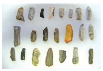
More Mesolithic stone tools from Harrol Edge, Frodsham. Source: Garner 2012

Hunter-forager-fishers of the Mesolithic were seasonally mobile, moving base camps to make the most of food and craft resources.  It is more than probable that in their seasonal rounds they were able to source chert and flint.  There is insufficient evidence from Beeston itself to suggest how stone was being processed, but of the 1500 pieces from the Harrol Edge collection, only 266 were actual artefacts, consisting of 232 blades and 34 scrapers, and the rest were by-products of the manufacturing process, representing multiple took making events.  This suggests that most of the artefacts were being made here, wherever the finished tools were eventually discarded, meaning that the raw material was brought to the site to be worked, rather than being worked where it was found.  Most of the objects were made on flint, mainly a distinctive banded variety, and only 8.6% were on a dark-coloured chert.  The chert tools may have been earlier in date than the flint examples.  Brooks says that the banded flint was not wholly ideal for knapping into shape, and probably would not have been the first choice if an alternative had been readily available.  Brooks felt that it probably came from the Peak District, but did not rule out north Wales as a possibility.
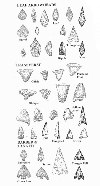
Knapped stone arrowheads from the Neolithic. Source: Malone 2001

In terms of the Neolithic stone use at Beeston, even early farmers were often far from sedentary, making their way through the landscape as they herded, seeking out craft materials on a seasonal basis and looking for new opportunities to exploit tracts of lowland and upland.  Early farmers were often far from sedentary, making their way through familiar landmarks of the landscape as they herded on a seasonal basis, seeking out craft materials on a and looking for new opportunities to exploit both lowland and upland environments.  It is possible that the local glacial tills provided the necessary flint for small tools, but even if travel had been required or the acquisition of raw materials, it would not have been necessary for the entire community to relocate.  For example, a dedicated resource acquisition group could have been dispatched from the group for this specialized task.  At the moment all we know for sure is that Neolithic groups were in the area, and that they imported flint and chert, either as raw material or as completed tools, from outside the area.

At Beeston the Early Bronze Age stone tool assemblage consists of a flint barbed and tanged arrowhead and four knives, all flint, and all nicely worked.  There is not much to be added to the above comments, but the knives were made of bigger pieces of flint than previous items, and it seems less likely that the raw material for such items would have been carried for any distances.  I have no idea whether or not flint pieces this size could have been found in the nearby valley gravels.

Sourcing materials for pottery
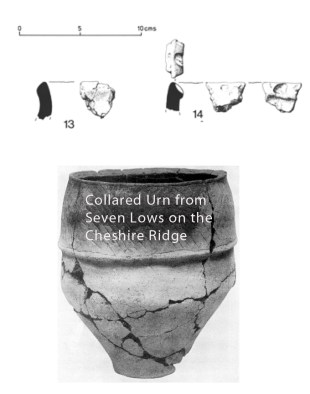
Collared urn sherds from Beeston (Royle and Woodward in Ellis 1993) and a photograph of collared urn from Seven Lows (source: Megalithic Portal)

The excavation report refers to three types of phase 1a and 1b pottery at Beeston.  All of them are made from local glacial drift clays characteristic of the Cheshire/Shropshire basin.  For example, the mineral inclusions (called temper) that were added to the collared urn clay during the pottery making process included quartz, sand, granite, rhyolite and basalt, all of which were common to other collared urns in Cheshire, and all of which could be sourced from local river valleys and glacial gravels in the area.  Because both the clay and the temper  were available locally, vessels could be manufactured within the immediate area, although there is no actual evidence to date for pottery manufacture at any of the Cheshire sites.  Although these vessels were hand formed rather than wheel-thrown, they still needed to be fired, and so far no evidence has emerged in the area for Neolithic kilns (usually simple pit kilns).


Final Comments

Although Beeston crag has produced the greatest evidence of early prehistoric occupation along the line of the Cheshire Ridge, this is probably due mainly to an accident of sampling.  Other hillforts were simply not excavated as extensively as Beeston, meaning that there could be plenty of early prehistory to be found at other Cheshire Ridge outcrops.  There have been some indications that there is more to be found.  At Eddisbury hillfort, for example, a possible late Neolithic cremation cemetery has been identified; at Seven Lows barrow cemetery at the eastern foot of the central outcrop, a recent excavation has just been published in the Chester Archaeological Journal (issue 8);  at Woodhouse  a small assemblage of Late Neolithic/Early Bronze Age stone tools were found, and at Helsby some early Neolithic activity has been identified.  Stray finds have been found elsewhere along the line of outcrops.
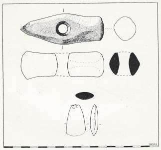
The so-called Beeston Hoard. Source: Varley and Jackson 1940

So far all the archaeological focus has been on the outcrops of the ridge, but that too is something of a sampling problem.  Because of the considerable agricultural value of the land across the Cheshire plain, it is unlikely that many upstanding sites are left to be found, and any settlement sites are likely to have been ploughed in. Aerial photography has proved to be of marginal value due to the water retentive properties of the glacial soil, which prevents it drying out sufficiently to show variations in the soil during dry weather.  However, there are hints that  prehistoric archaeology may yet be found.  On the plain not far from Beeston, the so-called “Beeston hoard” was found on the edge of a former freshwater spring, consisting of a Neolithic polished stone axe and an Early Bronze Age perforated stone axe-hammer.  The remains of a round barrow surrounded by a ring of stones and a circular ditch were found at Morreys garden centre at Kelsall, containing the cremated bones of a child in an inverted collared urn.  Unfortunately, discoveries like that have been few and far between.

Barbed and tanged arrowhead from Beeston – Late Neolithic/Early Bronze Age. Source: Ellis 1993

The discovery of earlier prehistoric sites along the course of the Cheshire Sandstone Ridge, many only excavated only briefly and some not excavated at all, establishes that there is the opportunity for further investigation, and hopefully further illumination.  There are a lot of questions remaining open about the earlier prehistory of both the ridge and the surrounding landscape.  Clearly, there is a lot of future potential for both non-invasive survey and excavation, should the funding be available.

Next

Following a visit to Beeston to enjoy the castle on a fine, sunny day last year, I became aware that Beeston had something of a prehistoric past, but I was surprised by how rich that past turns out to be, particularly when seen within the context of other sites on and around the Cheshire Sandstone Ridge.  At Beeston it begins with the Mesolithic occupation from around 9000BC, and then takes in the early Neolithic and the later Neolithic/earlier Bronze Age.  In Part 2, the very striking Bronze Age and Iron Age round-house and related discoveries on the Beeston crag take us all the way to the Romano-British period.


Sources for Parts 1 and 2:

Items in bold were used extensively in this post, with my thanks.

Books and papers:

Berridge, P. 1994. The Lithics.  In (ed.) Quinnell, H., Blockley, M.R. and Berridge, P. Excavations at Rhuddland, Clwyd, 1969-1973. Mesolithic to Medieval.  BAR 95, CBA.

Bradley, R. 2019 (2nd edition).  The Prehistory of Britain and Ireland. Cambridge University Press

Callaway, E. 2018.  Divided by DNA: The uneasy relationship between archaeology and ancient genomics.  Nature, March 28th 2018

Cunliffe, B. 1995. Iron Age Britain. English Heritage/Batsford

Cunliffe, B. 2005 (4th edition). Iron Age Communities in Britain. Routledge

Ellis, P. (ed.) 1993.  Beeston Castle, Cheshire. Excavations by Laurence Keen and Peter Hough, 1968-1985. English Heritage
https://archaeologydataservice.ac.uk/archiveDS/archiveDownload?t=arch-1416-1/dissemination/pdf/9781848021358.pdf 

Fairhurst, J. M. 1988.  A Landscape Interpretation of Delamere Forest. May 1988
http://delamereandoakmere.co.uk/wp-content/uploads/2017/03/fairhurst-delamere-landscape.pdf

Garner, D. 2012.  Hillforts of the Cheshire Sandstone Ridge. Cheshire West and Chester
https://www.sandstoneridge.org.uk/doc/D234636.pdf

Garner, D. and contributors 2016.  Hillforts of the Cheshire Ridge.  Archaeopress (appendices only available online)
http://www.archaeopress.com/ArchaeopressShop/Public/displayProductDetail.asp?id={2B433802-E7A0-4302-B2DD-95B7F3B2A493}

Garner, D. and contributors 2021. The Seven Lowes prehistoric barrow cemetery, Fishpool Lane, Delamere, Cheshire: a reassessment.  Journal of the Chester Archaeological Society, volume 91, 2021

Gibson, A. 2020. Beakers in Britain. The Beaker package reviewed. Préhistoires méditerranéennes no.8 (Ethnicity? Prestige? What else? Challenging views on the spread of Bell Beakers in Europe during the late 3rd millennium BC)
https://journals.openedition.org/pm/2077

Liddiard, R. and Swallow, R.E. 2007.  Beeston Castle.  English Heritage

LUC 2018. Cheshire East Landscape Character Assessment 2018. Land Use Consultants
https://www.cheshireeast.gov.uk/planning/spatial-planning/cheshire_east_local_plan/site-allocations-and-policies/sadpd-examination/documents/examination-library/ED10-Cheshire-East-LCA.pdf

Mackintosh, D. 1879.  Results of a systematic survey in 1878 of the direction and limits of dispersal, mode of occurrence and relation to drift deposits of erratic blocks our boulders of the west of England and east Wales, including a revision of many years’ previous observations.  The Quarterly Journal of the Geological Society of London 53, p.425-55

Malone, C. 2001.  Neolithic Britain and Ireland.  Tempus Publishing

Matthews, D. 2014.  Hillfort intervisibility in the northern and mid Marches.  In Saunders, T. (ed.) Hillforts in the Northwest and Beyond.  Archaeology NW new series, Vol.3, Iss.13 for 1998.  CBA NW.

Mayer, A. 1990. Fieldwalking in Cheshire.  Lithics 11, p.48-50
http://journal.lithics.org/wp-content/uploads/lithics_11_1990_May_48_50.pdf

Morgan, V.B. and Morgan, P.E. 2004.  Prehistoric Cheshire.  Landmark Publishing

Needham, S. 1993.  The Beeston Castle Bronze Age Metalwork and its Significance.  In Ellis, P. (ed.)  Beeston Castle, Cheshire. Excavations by Laurence Keen and Peter Hough, 1968-1985. English Heritage

Olalde, O. 2017. The Beaker Phenomenon and the Genomic Transformation of Northwest Europe.  bioRxiv May 2017
https://www.biorxiv.org/content/10.1101/135962v1.full.pdf

Ormerod, G. 1882.  The history of of the county palatine and city of Chester. Routledge

Ray, K. and Thomas, J. 2018.  Neolithic Britain. Oxford University Press

Royle, C. and Woodward, A. 1993.  The Prehistoric Pottery.  In Ellis, P. (ed.)  Beeston Castle, Cheshire. Excavations by Laurence Keen and Peter Hough, 1968-1985. English Heritage

Stuart, R. 1993. The flint.  In Ellis, P. (ed.)  Beeston Castle, Cheshire. Excavations by Laurence Keen and Peter Hough, 1968-1985. English Heritage

Varley, W.J. and Jackson, J.W. 1940.  Prehistoric Cheshire. Cheshire Community Council

Weaver, J. 1995 (second edition). Beeston Castle.  English Heritage


Websites

Habitats and Hillforts Project
https://www.sandstoneridge.org.uk/projects/habitats-hillforts.html

Sandstone Ridge Trust
Leaflets about the archaeology of the Cheshire Sandstone Ridge, available to download as PDFs
https://www.sandstoneridge.org.uk/about-sandstone-ridge-trust/publications.html

Archaeology

The Archaeology of Helsby Hill (PDF, 475KB)
The Archaeology of Woodhouse Hill (PDF, 487KB)
The Archaeology of Kelsborrow Castle (PDF, 495KB)
The Archaeology of Eddisbury Hill (PDF, 451KB)
The Archaeology of Beeston Crag (PDF, 498KB)
The Archaeology of Maiden Castle (PDF, 432KB)

Habitats

Broadleaf woodland (PDF, 352KB)
Meres and mosses (PDF, 391KB)
Lowland heath (PDF, 337KB)
Species-rich grassland (PDF, 331KB)

Insights Paper. The Sandstone Ridge Trust, 2018 (PDF, 7.6MB)
Sandstone Ridge Atlas. The Sandstone Ridge Trust (PDF, 22.3MB)
Delivery Model Options Appraisal. The Sandstone Ridge Trust (PDF, 2.4MB)

Ridge: Rocks and Springs

Ridge: Rocks and Springs Evaluation Report. The Sandstone Ridge Trust, 2017 (PDF, 37.4MB)
The Ridge: Rocks and Springs — a sandstone legacy. The Sandstone Ridge Trust, 2017 (PDF, 108.8MB)
Interim Report: Urchin’s Kitchen. The Sandstone Ridge Trust, 2017 (PDF, 67.5MB)
Ridge: Rocks and Springs Project Handbook 2015. A volunteer’s guide. The Sandstone Ridge Trust, 2015 (PDF, 7.7MB)

Habitats and Hillforts

Habitats and Hillforts Evaluation Report. Cheshire West and Chester Council, October 2012 (PDF, 12.5MB)
Hillforts of the Cheshire Sandstone Ridge. Dan Garner, Cheshire West and Chester Council, October 2012 (PDF, 10.8MB)
Captured Memories. Cheshire West and Chester Council, 2011 (PDF, 100.2MB)
Fertile Ground. Art & Photography inspired by Cheshire’s Sandstone Ridge. Cheshire West and Chester Council, 2012 (PDF, 66.5MB)

Geology
Introduction
Our Geological Heritage

https://www.sandstoneridge.org.uk/special-place/rural-land-uses.html


A visit to the Pontcysyllte Aqueduct near Llangollen – Thomas Telford’s iron trough 126ft over the Dee

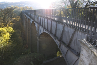
It is without question a marvel of modern engineering and a remarkable sight, but what strikes most people when they first see the 1000ft (c.305m) Pontcysyllte  canal aqueduct is that the handrail along the pedestrian walkway 127ft (38.5m) over the river Dee is only a few steps away from the other side of the narrow canal trough, which has no handrail at all to separate a boat user from a straight drop into the valley bottom.  Until you lean over the towpath’s handrail and look straight down, 127ft is a rather abstract number.  The photograph on the right shows me crossing it on a 40ft narrowboat in the 1990s on a two week canal holiday.  What you cannot see are the white knuckles with which I am gripping the tiller for dear life, in spite of having absolutely no fear of heights, because there was absolutely nothing between me and that drop.  The aqueduct, Grade I listed, and a UNESCO World Heritage Site since 2009, is the longest and highest in Britain.  It’s a long way down.

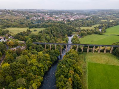
The Pontcysyllte Aqueduct passing over the Dee valley at Trevor. Source: Dronepics Wales

Seen from below or from a distance, the Pontcysyllte aqueduct is a fabulous sight, not pretty but truly awe-inspiring, and it shows exactly what Pontcysyllte is:  an iron trough built on 18 vast tapering brick piers, with 19 arches.  It was all about function, nothing to do with aesthetics, and has no ornamentation to soften it, but the sheer ambition of it grips the imagination and makes one look beyond the factual details of the thing.  It really is superb.  There is a path leading down along the side of the approach to the aqueduct into the valley below, a long but well maintained track to the valley bottom, where you can walk along the Dee and get a long at the aqueduct from a distance.  That’s one for another day.

It was a beautiful day, absolutely flawless, with cerulean blue skies, a golden sun warming one’s face, and a brightness of autumnal colours that takes some beating.  After attending the Remembrance Day commemoration at the Churton war memorial, with a memorable and moving address, and a two-minute silence filled with birdsong, I collected the car first, the parent next, and we proceeded towards Trevor, on the A539 to Llangollen.  There’s a brown signpost pointing to the aqueduct’s pay-and-display car park at the Trevor Basin, which is the home of a number of canal boat companies today, but when it was built was used for the transhipment of coal, building stone, iron products, timber and bricks, much of which was brought to the canal wharf by horse-drawn waggons.

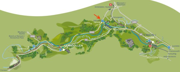
Map of the key canal features in the Vale of Llangollen. I have added a red arrow to show the best car park for Pontcysyllte. Click to enlarge. Source: Pontcysyllte Aqueduct & Canal World Heritage Site

Thomas Telford and his chosen team

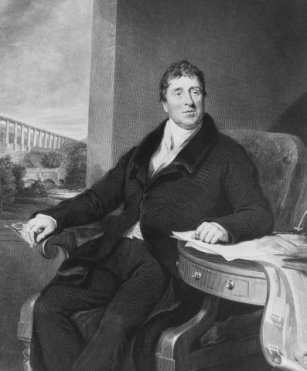
Portrait of Thomas Telford, who chose to be painted with the Pontcysyllte aqueduct in the background. Engraved by W. Raddon from a painting by S. Lane.

The aqueduct (built (1794-1805) was part of the Ellesmere Canal project.  It is one of the many British civil engineering projects that has the names of Thomas Telford (1757-1834), ironmaster William “Merlin” Hazeldine (1763-1840) and master stonemason John Simpson (1755-1815) attached to it, three men who had brought their particular skills to many different joint projects and in doing so had developed an invaluable relationship of trust and mutual respect.

Thomas Telford started his career as a stone mason, working in London on buildings such as Somerset House, and had ambitions to develop his career as an architect.  When he became the County Surveyor for Shropshire, he worked on a great variety of building projects including, by his own estimation, 40 road bridges between 1790 and 1796, two of which employed iron in their construction.   Hazledine had initially trained as a millwright, but  his family owned a small foundry  and Hazeldine went on to grow his iron casting business with the large Coleham Foundry at Shrewsbury.  Hazledine and Telford, both Freemasons, had met at Salopian Lodge  in Shrewsbury in 1789 and become friends and professional collaborators.  On one of his earliest projects in Shrewsbury Telford hired a childhood friend Matthew Davidson to oversee works, and Davidson employed master stonemason John Simpson who worked on many of Telford’s projects. Telford described Simpson as “a treasure of talents and integrity.”

Although Telford is by far the best known of the three, he, Hazledine and Simpson worked together frequently on many different projects to produce some of the great civil engineering constructions of their era, mainly bridges.  All three were involved with the Pontcysyllte aqueduct, where  Matthew Davidson also joined them, but the story of the canal starts before any of them were recruited to work for the Ellesmere Canal project.

Background to the aqueduct

The Trevor Basin today.

The big name in canal construction was James Brindley (1716-1772), who was responsible for building over 365 miles of canals by the time he died.  Brindely realized that any inland waterway network would need to connect to all the great navigable rivers that connected to the sea, including the Thames, the Mersey, the Severn and the Trent, incorporating other important navigable rivers like the the Avon and the Dee.  Most of his canals were contour canals, wherever possible built on the level and avoiding slopes so that locks and lifts could be avoided.  The network was therefore a sprawling affair, but it revolutionized transport, avoiding roads that would become mired and impassable in winter, as well as unnavigable sections of rivers, and the riverine problems of drought and flood.  Water into and out of the canal system was regulated and therefore predictable, and allowed year-round transport.  The advantages became very clear very quickly, and manufacturing and trading businesses began to locate themselves at critical points on the canal network.  Eagerness to invest in infrastructure resulted in a canal boom in the late 1780s and 1790s.  Each new section of canal required an Act of Parliament, subject to Royal Assent, and Act after Act was passed as the network expanded.

The complex arrangement of the Ellesmere Canal and its branches is shown as a think blue winding line. The thick blue line is the Dee. The yellow lines are roads. Click to see a bigger version. Source: Wikipedia

In 1791 a proposal for a canal to link the Mersey at Netherpool (later renamed Ellesmere Canal) to the river Dee at Chester and the Severn at Shrewsbury was discussed by three Shropshire entrepreneurs, carrying mainly coal, iron and lime, supported by other goods as well.  It was decided that a branch would be needed to Wrexham and Ruabon and onwards, via Chirk, bypassing Oswestry at its west, to Shrewsbury in the south with a branch to Whitchurch in the east and another to Llanymynech.  Originally it was planned to run a branch from Ruabon to reach the Irenant slate quarries near Llantysilio, via Llangollen, but this was at first dropped and later revived for different reasons (discussed below).  That branch would in turn connect to the Montgomery Canal from Frankton Junction via Welshpool to Newtown in mid Wales (for carrying limestone, coal, timber, stone and slates).

This seriously ambitious plan found sufficient support for a surveyor to be hired and possible routes to be explored.   William Jessop, an experienced canal engineer, was hired to head up the project and oversee all of its different components.  After disagreements over the final route were resolved (albeit not to everyone’s satisfaction), the Ellesmere Canal proposal went through parliament and received its Royal Assent in April 1793.  There were still a lot of technical and logistical details to resolve, including how the canal was to cross the Dee and Ceiriog valleys.

It was clear that Jessop needed help, and although the internal promotion of William Turner was Jessop’s first choice, Telford was brought in without his input. It is not certain how Telford, increasingly bored with life as a county surveyor, managed to insert himself into this ambitious engineering project, but the canal was already generating considerable excitement in the area and it looks as though he heard of the position and sought the support of one of Britain’s most prominent industrialists, John Wilkinson, to help him secure it.  Jessop made it clear in his letters what he thought of having Telford, who he had never met, brought in against his wishes as his right hand man, and refused to attend the meeting that appointed Telford to the Ellesmere Canal Company.  In spite of this rocky start, Jessop and Telford seem to have hammered out a decent working relationship, with Jessop teaching Telford what he needed to know about canal construction, and Telford injecting some ideas into the project.  Like Jessop, Telford managed to broker a deal to enable him to carry out other projects when his personal presence was not necessary, and this enabled him to work on other civil engineering works whilst the Ellesmere Canal was being built.

Building the aqueduct

Work began at Netherpool on the Mersey, renamed Ellesmere Port, in 1793.  The 9-mile canal ran down the Wirral to meet the Dee at Chester, and went so well that it opened for traffic in 1795 and was an immediate success.  While this section was underway, discussions were underway about how the canal might cross the Dee.  The original idea presented to the directors by Jessop and Turner, and apparently not opposed by Telford, was a relatively low level stone channel crossing three stone arches, with step locks either side to manage the ascent to and descent from the level of the canal to the aqueduct.   This would have been an expensive option, requiring not only the locks but the management of the water that would feed the locks.  Even after this had been agreed in principle, concerns resulted in a new plan for an iron channel on stone columns.  It is likely that it was proposed by Telford and supported by Jessop partly because it would have reduced the cost as iron was lighter, easier to work and move, and cost less.  A sketch by Telford from March 1794 survives showing an early version of this aqueduct design.

Telford’s Grade 1 listed Longdon-on-Tern aqueduct in Shropshire, 1796. Source: Chris Allen, Wikimedia

In early 1795 Telford had the opportunity to try out a smaller, less ambitious version of the design at Longdon-on-Tern on the new Shrewsbury Canal, on which Telford was also working, as replacement for the incumbent engineer who had died mid-project.  Later in the same year he had built a fully navigable iron aqueduct on a canal that had none of the problems of leakage or shattering that had worried other engineers.  Whether or not this was taken into account by the directors of the Ellesmere Canal Company, they decided in the same year to go for the iron trough on immense stone piers that was eventually built.

Telford’s friend and frequent collaborator, master mason John Simpson soon joined him on the project.  Telford also brought in Matthew Davidson, his childhood friend of Telford, a stone mason, civil engineer and excellent organizer, to oversee the bridge works.  Telford and Davidson had worked successfully together on Telford’s Montford Bridge project of 1790 – 1792.  Shortly afterwards, William Hazledine arrived to establish an ironworks and take charge of the construction work for the iron ribs and the trough.  By assembling three men that he had worked with before and trusted absolutely, Telford was not only ensuring that the project was in good hands, but that he had a team who could operate in his absence. The foundation stone for the aqueduct was laid on 25th July 1795.

Jessop and Telford made wooden models to test the design for the trough, finding that 1000s of iron parts would be needed.  The cast iron for the aqueduct was made of cast iron that was produced in William Hazledine’s new iron foundry nearby at Plas Kynaston, Cefn Mawr.  Hazledine established the Plas Kynaston foundry to service the construction of the Pontcysyllte aqueduct, thereafter taking advantage of the canal network to carry his cast iron in segments to be transhipped by river or sea to where it was needed.  When he built the Eaton Hall Iron Bridge at Aldford on the river Dee (described on an earlier post) it was from Plas Kynaston that the iron was shipped by canal.

After 1801 Jessop was much less involved and Telford also had interests elsewhere, and Telford was also involved in other projects, leaving Davidson, Hazledine and Simpson to run with the project.  The piers rose steadily, each built in turn from south to north by, at the peak of the project, over 500 men.  Jessop had been desperately worried from the beginning by the dangers to workmen’s lives of such tall piers, and safety precautions were taken very seriously, with the loss of only one life.  The iron parts were manufactured as needed at Plas Kynaston, and were numbered according to the order in which they would be needed so that only pieces needed at any one time would be delivered to the site.  First, ribs of iron were fitted to the piers, and then the trough was bolted on top, after which a wooden towpath was fitted to the side.  The entire project was finished in 1805, and opened on a sunny afternoon on November 26th 1805 at a grandiose ceremony followed by a lavish feast.  The entire cost for the aqueduct project was £47,018, which in today’s money translates as around £617,855 (National Archives Currency Convertor).

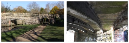
Metalwork over and under the arch at the left-hand Rhos y Coed bridge.

Although not as visible in the finished design, iron was also used in the Chirk aqueduct on the Llangollen canal where ten semi-circular masonry arches were crossed by a water channel with an iron bed plate and brick sides sealed using hydraulic mortar.  As well as in the aqueducts, iron was used in various ancillary structures too.  for example, Bridge 29, Rhos y Coed, at the Trevor Basin has visible iron metalwork supplementing the stone arch, and iron was used to cap the weir at the Horseshoe Falls.

The role of the aqueduct

Map from Nicholson’s Guide to the Central canal system, showing the stump end (framed in orange) of the planned Ruabon to Chester section of the canal, which was never built and now houses the attractive Trevor boatyard where the visitor centre is located. Source: Nicholson 1989

The Pontcysyllte aqueduct was almost immediately  in danger of becoming something of a white elephant, because its original role as a direct route to Wrexham and Chester was never fulfilled.  The section that led past Trevor Basin over the aqueduct was supposed to run straight on to the west of Ruabon, via Wrexham and on to Chester where it would link with the Wirral stretch leading to the Mersey and to the  Dee and the Shropshire Union Canal.  All that is left of the Trevor-Ruabon-Wrexham-Chester branch is a stump end occupied by the Trevor Basin, where the car park is located.  This is clearly visible on Nicholson’s map left, where the main line of the canal comes to a sudden, abrupt end.

The abandonment of this important part of the original plan was due to both engineering problems and financial issues.  There were only  two obvious engineering options – an enormous tunnel or a series of locks climbing towards Wrexham and another descending into the Cheshire plain where the canal could run along the flat plain to Chester.  The tunnel would have been appallingly costly, and it was difficult to know how the locks, by no means a low-cost option themselves, could have been supplied with the sufficient water.  Although other technologies were considered, they were rejected for reasons of practicality and cost.  This left the problem of where the water was to come from to feed the rest of the Ellesmere Canal and its branches.

Horseshoe Falls

At the far end of the Llangollen canal is Telford’s great arc of a weir, today known as the “Horseshoe Falls,” marking the point at which the Dee begins to feed the Llangollen canal.  An original survey had considered using the water of the Dee as it fell from Snowndonia via Lake  Tegid at Bala and through the Vale of Llangollen as a water source for the canal.  The idea had been to link the canal to a slate works, feeding the canal at the same time.  This proposal was now revisited.  The owner of Lake Tegid gave his permission and the plan was actioned.  At the Horseshoe Falls the canal is fed with water from the Dee via a sluice and meter, and today carries over 11 million gallons of Dee water a day, emptying it into Hurleston reservoir, just north of Nantwich, where the Llangollen Canal meets the Shropshire Union Canal.  I will be posting more about the Horseshoe Falls weir on another day.  There is no turning point for vessels over 10ft long beyond Llangollen, so the final stretch is only used by minimal traffic today.

This means that the vast aqueduct, such a remarkable feat of civil engineering, would only ever lead to the relatively unimportant narrow section of canal and feeder to a complete dead end at Llantisilio after passing high through Llangollen.  This navigable channel is approached from the aqueduct by negotiating a sharp left-hand corner just beyond the exit of the trough.  Although this seems like a sad role for an aqueduct that should have carried many times the traffic that it eventually did, without the aqueduct there would have been no water to feed the rest of the system.

Even without the Ruabon – Chester link, those wishing to carry all their goods by canal were still able to connect to the main canal system, although to reach Chester they had to take a very long way round, and Wrexham was excluded completely.  The Llangollen canal still linked to the Shrophsire Union at its eastern end, from which the rest of the vast canal network could be reached.

  • Chester could still be reached by travelling the full length of the Llangollen canal to Hurleston Junction, just north of Nantwich, on the Shropshire Union Canal.  From here Chester was nearly 16 miles away.
  • Just to the north of Hurleston Junction was the Middlewich Branch, which headed east and linked to the Trent and Mersey Canal, from where Manchester, Stoke on Trent, the eastern Midlands and Yorkshire could all be reached.
  • In the opposite direction, from Hurleston Junction the Shropshire Union ran directly to Birmingham, which was a vast junction for canals in all directions, including London on the Thames and Gloucester on the Severn.

The Cefn Mawr railway viaduct, which opened in 1848.

Along the line that the original canal would have taken, a cast iron tramway was built to connect local collieries and ironworks with the canal, the iron supplied by Hazledine.  This made the Trevor Basin a particularly important hub of activity, taken delivery of bricks, tiles, coal, iron limestone, slate and sandstone for transhipping along the canal.  It was also a boatyard, with  working narrowboats being built and repaired by Hills Boatyard in the dry dock next to the Visitor Centre (now occupied by a floating take-away café).  Later, there was an interchange with the steam railway.

Visiting Pontcysyllte

A small pay-and-display car park is available for visitors at the Trevor Basin, now the home of some canal trip and holiday companies.  There is also a pub with outdoor seating, and a take-away small café on a little boat next to the visitor centre.  There is a lot of disabled parking provided for in the small car park, which is reached from the A539 in Trevor, clearly signposted with brown heritage signposting.   The aqueduct is a very short walk from the car park, and the towpath heads for miles in both directions.

If, before or after crossing the aqueduct, you are interested in finding out more about the general context of the aqueduct and its location in relation to other parts of the canal, at the Trevor Basin there is a visitor centre, a small but nicely put together display space.  As well as a map of the area that takes up a wall and shows all the main features of the landscape and the canal system itself, there is a display of some of the tools that were used in the construction of the aqueduct, which are startlingly basic, and photographs and artists’ impressions of some of the supporting works, including the foundry at Plas Kynaston.  There are ring folders full of additional information, including facts and figures, that you can look through.

Walking the aqueduct itself is not for everyone.  The towpath is rock solid, with a tall handrail on the valley side, but only wide enough for two people, so there is a lot of stopping still to allow others to pass and there is nothing to stop you falling into the canal.  The canal is only just over 6ft (1.8m) wide, and beyond that is an unrestricted (no handrail, no nothing) drop 127ft to the valley floor.  A couple who I passed told me that they were determined to walk the full length and back, but were conquering their fears to do so, and they were gripping firmly to the handrail.

An alternative to walking is to cross by boat.  There are a number of short cruises that leave the Trevor Basin and run for about 20 minutes before turning and coming back (depending on which one you take and the time of year).

For those with uncooperative legs, everything is on the flat, so it is a very good walk for those who find uphill sections of walks difficult.  After rainfall, towpaths always become a bit muddy, and can be slippery, but even though we’ve had some rainfall recently, it was fine.  The towpath between Trevor and Llangollen is beautiful, and a good choice if you can face the aqueduct.

I noticed that one of the passenger boats said that it was suitable for disabled passengers, but I would recommend getting in touch with them first to find out about timings, prices and suitability for different types of disability.

Sources

Books and papers

Glover, J.  2017.  Man Of Iron.  Thomas Telford and the Building of Britain. Bloomsbury

Lynn, P. A. 2019.  World Heritage Canal.  Thomas Telford and the Pontcysyllte Aqueduct.  Whittles Publishing.

Nicholson, R. 1989 (4th edition). Nicholson/Ordnance Survey Guide to the Waterways 2: Central. Robert Nicholson Publications and Ordnance Survey

Rolt, L.T.C. 1958, 2007.  Thomas Telford. The History Press.

Pattison, A.  n.d. William Hazledine (1763-1840): A Pioneering Shropshire Ironmaster.  West Midlands History https://historywm.com/articles/william-hazeldine-1763-1840  (Pattison’s full 278-page M.Phil, on which the article is based, is available here: https://etheses.bham.ac.uk/id/eprint/3358/1/Pattison12MPhil.pdf )

Websites

Canal and River Trust
Montgomery Canal
https://canalrivertrust.org.uk/enjoy-the-waterways/canal-and-river-network/montgomery-canal?gclid=CjwKCAiAp8iMBhAqEiwAJb94z7aIVzLoaYuqtwbDdRQsaUL73ssnmF_u1LpoURZmI9YxVUlrKi15whoCtxoQAvD_BwE

DronePics Wales
Pontcysyllte
https://dronepics.wales/pontcysyllte/

Engineering Timelines
Longdon-on-Tern aqueduct
http://www.engineering-timelines.com/scripts/engineeringItem.asp?id=308

Grace’s Guide to British Industrial History
James Brindley
https://www.gracesguide.co.uk/James_Brindley
William Hazledine
https://www.gracesguide.co.uk/William_Crosley_(1802-1838)
William Jessop
https://www.gracesguide.co.uk/William_Jessop

Pontcysyllte Aqueduct and Canal World Heritage Site
https://www.pontcysyllte-aqueduct.co.uk/


Shocklach motte and bailey castle(s) at Castletown

Two sites with one name

Shocklach East is on private land, but its north side can be viewed from the north over a short fence. The image has been stitched together from three photographs, hence the slightly odd appearance.

The name Castletown seems rather glamourous for what today is a wholly rural, agricultural landscape.  Castletown is located south of Crewe-by-Farndon and north of the village of Shocklach and west of the Castletown Farm on a peaceful country road.  On the Ordnance Survey map, which I was studying when working on the post about the 1854 Chester to Worthenbury toll road, there are some interesting details that merited further investigation.  Where the small Castletown bridge crosses a small stream, that eventually flows into the Dee, there are two fairly large sites shown flanking the road.  Collectively, even though they are near to Castletown, they are known as Shocklach Castle, although they actually make up two separate castle sites.

Map showing the sites at Shocklach either side of the Crewe-by-Farndon road as it crosses Castletown Bridge. Source: Public Map Viewer

A visit to the two-part site marked on the map means looking from the side of the road.  The site is not on a public footpath but is very close to the road, and some of the earthworks are clearly visible. As you can see on the above map, the site to the west can be seen from the Crewe to Shocklach road, whereas the one on the other side of the road is best seen from the lane that heads west to Castletown Farm.  For the purposes of this post, I have referred to these sites as Shocklach East and Shocklach West.

Click to see a bigger image.  The location of the Castletown / Shocklach mottes, south of Crewe by Farndon and to the north of Shocklach. Source: Public Map Viewer

The Shocklach site is a scheduled monument, which means that it is protected by the state.  It is recorded as Shocklach Motte and Bailey Castle by the government quango responsible for scheduled archaeological and historic monuments, Historic England.  Its listing code is 1012620, and it was first scheduled in November 1926.  The listing covers both Shocklach East and West.  It is well worth repeating Historic England‘s “Reasons for Designation:”

Shocklach Castle is of particular importance as one of a group of early post-Conquest (c.1100) mottes forming a defensive system aimed at curbing constant Welsh raids on the rich farming areas of south Cheshire. Additionally the site lies within an area containing the most important concentration of medieval monuments in Cheshire. These monuments include two shrunken medieval hamlets, a defended green lane, a Norman chapel, well preserved ridge and furrow, a ford across the River Dee, and a complex of communally owned watermeadows.  The monument is situated in a dingle thought to have been one of the ancient trackways utilised by the Welsh in their frequent raids into southern Cheshire.
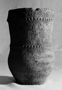
It is difficult to imagine this sleepy road and its flanking fields having a strong military presence.  From the early 12th century onwards, however, the motte and bailey site sat on the edge of a settlement whose people were centred on successful economic activities including cultivation and probably livestock management, albeit fearful of attack from Wales.

Archaeological investigation at Shocklach West during the 1980s by the University of Chester (in those days called University College Chester) revealed a lot more than can be seen today.  As above, the site consists of two sets of earthworks, one to the west of the road, covered in trees, and one to the east, which is free of vegetation.  The two sites are scheduled together under one registration number, but it should not be forgotten that they are two separate entities, each of which needs to be understood in its own right.  Rachel Swallow, who excavated the site, talks about the confusion caused by the presence of two separate entities, one each side of the road:

There is a general, and historic, confusion about the function and purpose of the two monuments at Castletown.  The Ordnance Survey (OS) 25 inch maps of 1879 and 1911 clearly mark the monument to the east as a ‘castle’ and ‘moat’, with that to the west of Castletown Bridge as a ‘moat’. The survey of 1964 reinterprets the mound to the west as a ‘motte’, with the earthworks 30 metres to the east marked as a ‘moat’, but not as the site of a castle. In the early nineteenth century, Ormerod stated that the earthworks to the east appear unconnected with those he seemed to believe were of the Norman fortress to the west.

In the discussion below, the two will be dealt with separately first, before looking at how they might related to one another, but first a little look at what motte and bailey castles actually are.

Background – what is a motte and bailey castle?

Miniature from illuminated Chronicle of Matthew Paris (1236-1259), from BL MS Cotton Claudius D. vi, f.9, showing Henry I of England enthroned. Held and digitised by the British Library. Source: Wikipedia

Motte castles are medieval fortifications introduced into Britain by the Normans, made up of a defensive structure built on an artificial mound.  The bailey was a small group of buildings fenced and sometimes moated, attached to and protected by the motte castle. By the time that the Shocklach motte and bailey castle was built, either towards the end of the reign of William the Conqueror or at the beginning of the reign of Henry I, there were political and territorial disputes, particularly within Wales and along the Welsh-English borders.  One of the manifestations of this ongoing disruption was frequent cross-border raids to secure territories and resources.  

Armed dispute over territory and resources has a long heritage in Britain.  From the mid 4thmillennium BC there are the first signs of violence related to competition for resources, and it is likely that livestock raiding was an ongoing problem from that point forward.  It has been suggested, for example, that protection of livestock and  of grain, as well as of people, could have been a primary role of fortified Iron Age hillforts.  

When William the Conqueror arrived in 1066, he began to replace the existing aristocracy with those that he had brought with him, men that he could trust to support him to take control and enforce peace.  English names were quickly replaced by Norman ones in records and by Domesday, merely 20 years after the conquest, only 8 percent of landholdings were held in English names.  The Normans built castles to help them to govern and to demonstrate their power.  Castles, initially turf and timber, sprang up everywhere, later replaced by bigger stone structures.   As Crane observes:  “early Norman castles had more in common with Roman marching forts than with tribal hillforts.  They could be built with astonishing speed, they were virtually impregnable and their construction had more to di with military expediency than with cultural bonding.”

Dorling Kindersley reconstruction of a small motte and bailey castle showing the main features. Fortifications could be very small. Source: Dorling Kindersley Find Out website.

In a motte and bailey arrangement a fortification sits on a natural or artificial mound with an accompanying settlement in a walled/fenced area at its foot, sometimes surrounded by a moat or ditch.  Where the mound was specially built, it could be made of earth, rubble, or both.  A palisade, or fortified fence, surrounded the apex of the mound, on which some sort of tall fortified structure was built, providing views over the surrounding countryside to watch for any oncoming attack.  Most are now covered in grass and sometimes trees.   Where a bailey is also present a palisaded enclosure at the base of the motte, and connected to it, often contained buildings for people, livestock, and grain and water storage, and may surrounded by a bank as well.  These have often vanished from sight today.  Where water was locally available, these defences could also include moats (which in the soggy Cheshire area, might have doubled up as useful drainage ditches).  

Cardiff Castle’s shell keep. Source: Wikipedia

Motte and bailey castles are found in all areas where human population is found, including towns, villages and rural areas.  Although they are generally characterized as being located on high ground, in good strategic positions that are highly visible from the surrounding area, this is more difficult to arrange on the flat expanses and floodplains of Cheshire.  Historic England says that there are over 600 motte castles and motte-and-bailey castles are recorded in England, of which around 100-150 are motte castles without accompany baileys.

Although the best known examples were multi-purpose bases combining the functions of elite residences, administrative centres, strongholds for the protection of economic resources and the material objects that made up personal wealth, and, when needed, a garrison for military activity, there are many much smaller versions, particularly in rural areas, that worked as secondary support to bigger castles and served mainly as watch-posts with small garrisons attached.  Ruined sites and modern artistic reconstructions based on excavations indicate that these might be very modest affairs, with a motte might support a fortification that was little more than an elaborate, defendable shed overlooking a small enclosed gathering of buildings into which people and livestock could retreat, as the excellent reconstruction above from the Dorling Kindersley Find Out website suggests.  They became more elaborate as time went on, evolving into the shell keep, the successor to the the motte and bailey castle.  An example is the shell keep on a motte at Cardiff Castle, shown above the left, which shows how truly impressive they could become.


The Castle Sites

Aerial view of Shocklach East in the early 1980s the shadows highlighting some of the earthworks, together with ridge and furrow fields. Source: Williams, R. 1983, plate 2, page 60

The earliest motte and bailey site at Castletown, known as the Shocklach castle, is thought to have been originally built by the Barons of Malpas sometime around 1100, the year in which Henry I acceded to the English throne, in a co-ordinated effort initiated by William the Conqueror and built on by William Rufus to demonstrate English power and to protect the region from frequent Welsh raids.  In the early Medieval period, Malpas, Shocklach and Castletown lay in Anglo-Saxon Mercia, but after the Conquest they quickly came under the control of Norman Chester.

The names and lives of the individual barons at this time are by no means clear, and the line of succession is particularly confusing.  Cotgreave’s 2008 research has ruled out a number of earlier proposals, but in spite of his efforts he has been unable to provide a definitive story of the 12th-13th Century Barons of Malpas.  The barony of Malpas had covered a huge chunk of southern Cheshire at Domesday in 1086, when it was under the lordship of Robert fitzHugh, and consisted of some 43 townships, but it was divided into two halves (moieties) at some point after Domesday, possibly due to the lack of descendent in the direct line.  Part of the barony was apparently granted to Gruffydd ab Owain at around the time that Shocklach was built, potentially “one of the Welshmen on whom Henry I lavished grants in 1102 as bribes for support against the early of Shrewsbury.”  Redistribution of baronial lands was common when kings rewarded loyalty with property.  However, the land seems to have then passed into the hands of two other families, the Patrics and the Belwards.  For anyone wanting to follow the story further, see Cotgreave’s paper (in Sources, below). 

Distribution of castle sites under the control of Chester. Source: Swallow 2013-14.

Although Shocklach was held by the Malpas manor, it was occupied by families, who owed service to Malpas.  Rachel Swallow, who excavated Shocklach West, describes how between 1208 and 1229,  it was granted to David de Malpas (1185-1252) whose daughter was married to Rhodri ap Gruffudd of Gwynedd (c.1230-1315), probably a diplomatic alliance to reduce hostilities between Cheshire and Gwynedd.  He apparently had no right to his wife’s lands and Shocklach passed to new families (Sutton and St Pierre) as moieties (i.e. the land was halved for sharing).

Whichever family built the first Shocklach motte-and-bailey castle, it was one of a number built along either side of the river Dee to protect English farms and resources against the Welsh.   Shocklach was only one location in a string of defensive sites.  Looking at the local Ordnance Survey maps, there are motte and bailey castles and, often separately, moats all around this area.   The map above, from Rachel Swallow’s excavation report, shows the distribution of all the local ones, forming, depending on how you look at it, either two very rough lines north to south (running either side of the River Dee) or one zig-zagging line that spans and incorporates the Dee.

Whatever else we take away from the artists’ motte-and-bailey reconstructions, like the Dorling Kindersley one above, when we consider the sheer volume of these structures on OS maps of the area, the overall impression is that defence of even small settlements was an everyday component of life, made particularly important by proximity to the Anglo-Welsh border.

Shocklach East

Shocklach East. Source: Swallow 2013-14

Shocklach East is most clearly visible from the lane that leads to Castletown Farm.  It consists of a D-shaped moat or ditch (which is now filled with trees and shrubs) that protected a motte, which remains free of tree cover.  The motte-and-bailey earthworks to the east at Shocklach are heavily eroded but are nontheless better preserved than those to the west, on the other hand, are larger and lower than those to the west,

The motte is in the southeast ern section of the site and is today c.4-5m high (measured from the base of the ditch).  This is not visible from the road. It is oval-shaped, and surrounded by a low bank.

The ditch is on three sides, occasionally referred to as a moat, with a causeway that gives access to the main enclosure on the northeastern side.

Swallow says that the D-shaped bailey to the south is typical of the area, with kidney-shaped bailey and similar to that of Pulford castle. It measures c. 70 x 78m internally, and it too is surrounded partially by a ditch to the north a by a stream valley to the south.  Suring the survey, it was recorded that the ditch was up to 2.7m deep.  Although now dry, the ditch would have been joined to the stream to form a small moat.  

This motte and bailey castle was not physically attached to the Shocklach West site, which is a full 30m away.

Shocklach West

Behind this dense hedge is Shocklach West. I did my best to lean through the mass, but absolutely nothing was visible through the wilderness of vegetation.

The Shocklach West motte has not been excavated and, indeed, it would be difficult to see how it could be done efficiently.  It is completely hidden from view by trees that have been established over large section of the land, and the roots will be playing havoc with the underlying contexts, rearranging any structural remains and moving around objects.  I did my absolute best to get some sort of view through the shrubs, but there is nothing at all visible at the time of writing (mid-September) due to the dense tangle of shrubs and weeds around the trees.  A return visit in winter after the leaves have fallen and the weeds have died down may reveal more of the outline of the motte.

This view, taken from near to Shocklach West, shows the sort of view that the structure on the top of the motte would have had.

Like most rural motte and bailey castles, only the most labour-intensive features have survived.  The motte is around 5-6m high, which is quite sizeable after centuries of erosive forces, and there are remains of a silted ditch on south, southwest and eastern sides, beyond which there is an outer bank.  On the north and west sides, the bend in the stream forms another line of defence.  The size is consistent with other motte and bailey sites in the Welsh Marshes dating from the 11th and 12th centuries, spanning both Saxon and Norman periods.

The site is located on a hill with superb views over the Dee valley to the west with the Welsh foothills in the distance, and across fields to the east.

Another view taken from near to Shocklach West, showing the sort of view that the structure on the top of the motte would have had, across the surrounding woodland towards the Welsh foothills.

Two Castles, two stories? 

Both castles benefitted from a potable water source provided by the stream, and may have been positioned partly in relation to the road that passed between them.  Both were located on good agricultural land, indicating that they had something to protect, and were fairly evenly spaced from other castles that dotted the Dee valley.  Medieval hamlets in the Castletown area may have been served by one or both of the castles.

View from Castletown to the east

Swallow offers a number of suggestions for why two castles were required so close together, which take into account that no excavations have taken place at one site, and little dating material was found at the other, making it uncertain if the two sites were precisely contemporaneous or if one preceded the other.  Here are some of the options that she discusses:

  1. The castles could have been used together to protect the road that passed between them, a major route between north and south along the border.
  2. After the paired mottes were built contemporaneously, a bailey might have been added to the east later, in a lower position that was strategically less valuable than the motte to the west.  Some objects found at the site lend support to this interpretation, as does the fact that the eastern bailey seems to post-date some medieval ridge and furrow fields. 
  3. The pair has similarities to another pair of mottes in East Chelborough, Dorset, where a second motte replaces the first.
  4. Documentary sources refer to dual lordship and moieties, and it is possible that the monuments were held by different interests, perhaps representing Caldecott and Shocklach.  Swallow suggests, for example, that the motte to the west could like within Church Shocklach township, rather than Caldecott or Castletown. 
  5. A toll gate recorded in the route between the two sites suggests that this was a popular route for travellers and traders.  Twin castles, or an earlier and later castle may have been established to ensure that territories on either side of the road both benefited from toll income.  Although the site may have been established initially for military purposes, commercial interests may have become important too.  

See Swallow’s paper, which is available online, for more details.

Contemporary sites at Castletown

There are other sites in the Castletown area near Shocklach East and West, which are also scheduled.

The first consists of the remains of a village or large hamlet, some farm buildings and a ridge and furrow field system. Like the two castles, these have been included under one listing by Historic England, with the identification number 1016588.  These include at least six tofts (house platforms) and crofts (small farming enclosures) that make up the remains of hamlets to the north and south of Castletown Farm.  As well as the surviving components of buildings there are visible remains of ridge and furrow cultivation that lie to the east of the hamlets.  Although these remains are divided, this is only because the later Castletown Farm was built over other parts of the former settlement.  


Later history of Castletown

Swallow mentions that Castletown Bridge, which carries the road across the stream between the two castles, “was probably the site of the medieval toll gate, catching people and animals entering Cheshire from Wales to the south and west, as Shocklach castle guarded the only road into Cheshire at this point.”  Documentation suggests that a toll gate was present there
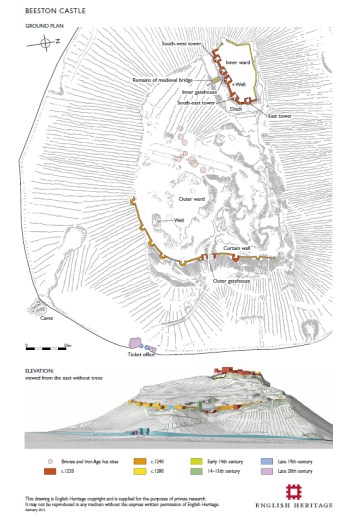
from at least 1290.  Swallow suggests that Shocklach castle had a defensive function until at least the latter part of the fourteenth century and probably became the site of a fortified manor house, mentioned in 1499, when the notorious judge Lord Dudley claimed rights to Shocklach, “and to have a toll for himself and William Brereton.”   Passing into the hands of the the Breretons, it then passed to the Hills and the Drakes.


Conclusion

Although today Shocklach sits in a peaceful area that consists mainly of farms and large fields divided by hedgerows, it is clear that from the early 12th Century, the twin mottes at Shocklach were important components in a wide line motte-and-bailey castles that made up much of the defence of the border between England and Wales.  Then too there were small hamlets and farms.  Although these lay on territory that was under dispute and where livestock and stored cereals may have been seen as easy pickings, they were supported by the presence of the castles.  Other nearby sites that are relevant are a Medieval field system at Castletown Farm and the local Shocklach Church, which retains a Norman arch.  The latter will be discussed on another post when I can gain access to the interior.  Between them these and other Medieval sites along the Dee valley the Castletown sites preserve part of the story of life along the Welsh-Cheshire border at this time.

Visiting: 
You can pull over on the edge of the relatively quiet road (pull well over in case of agricultural vehicles), but the site, on both sides of the road, is on private property so you cannot actually walk on or around the site.  You can only view it from the roads.  Before leaf-fall, Shocklach West is completely hidden by vegetation, but the north side of Shocklach East can be seen over a short fence.  I wouldn’t recommend it for a walk, because it is not on a public footpath, there is no pavement, the verges, where available, are narrow and uneven and the road is very bendy and rather narrow, not ideal for avoiding any traffic, most of which travels at some speed.


Sources:

Books and papers:

Cotgreave, P. 2008.  The Barony of Malpas in the twelfth century.  Transactions of the Historic Society of Lancashire and Cheshire (2008), 157, (1), 1–32.
www.hslc.org.uk/wp-content/uploads/2019/01/157-2-Cotgreave.pdf 

Reynolds, S. and White, G. 1997-98.  A Survey of Pulford Castle.  Chester History XXXVII, p.23-25

Pryor, F. 2010.  The Making of the British Landscape.   How We Have Transformed the Land, from Prehistory to Today.  Allen Lane

Swallow, R. 2013-14. Two For One:  the Archaeological Survey of Shocklach, Castle, Cheshire. Cheshire History Journal, No.53, 2013-4
https://www.academia.edu/4577267/Two_for_One_The_Archaeological_Survey_of_Shocklach_Castle_Cheshire_in_Cheshire_History_Journal_No_53_2013_4_Cheshire_Local_History_Association_2013_

Williams, R. 1983. Church Shocklach, Castletown:  the “moated” site. Cheshire Archaeological Bulletin 9, p.59–60
http://www.cheshirearchaeology.org.uk/wp-content/uploads/CAB-Vol-9.pdf 

Williams, R. 1983. Castletown.  A Deserted Hamlet? Cheshire Archaeological Bulletin 9, p.61
http://www.cheshirearchaeology.org.uk/wp-content/uploads/CAB-Vol-9.pdf


Websites:

Ancient and Scheduled Monuments

https://ancientmonuments.uk/114798-medieval-settlement-and-part-of-field-system-at-castletown-farm-shocklach-oviatt-and-district

Historic England
Shocklach motte and bailey castle, list entry 1012620
https://historicengland.org.uk/listing/the-list/list-entry/1012620
Medieval settlement and part of field system at Castletown Farm
https://historicengland.org.uk/listing/the-list/list-entry/1016588
Church of St Edith
https://historicengland.org.uk/listing/the-list/list-entry/1228322

Archaeology and Metal Detecting Magazine
Shocklach: Its History and Archaeology. By Dave Sadler 5th September 2021
https://archmdmag.com/shocklach-its-history-and-archaeology-by-dave-sadler/


Ranulf III’s Beeston Castle #2 – The castle, the walk, the visit

The gateway to the inner ward seen from the outer ward

In Part 1, I introduced Ranulf III, the powerful descendant of King Henry I, who started building Beeston Castle in 1220, and during his lifetime was close to four kings of the Middle Ages:  Henry II, Richard I (“the Lionheart”), John (“lackland”) and Henry III.

Here, part 2 looks at the castle itself, the walk up to the castle, 18th and 19th Century artistic interpretations of the castle, and practical visit details, including notes on accessibility for those with less than cooperative legs. The two parts are designed to be read together, as many of the photographs of the castle are in Part 1.

Topographical plan showing the site elevation and key features, colour-coded to show different construction phases. Source: English Heritage. https://www.english-heritage.org.uk/siteassets/home/visit/places-to-visit/beeston-castle/history/serpentine/beeston-castle-phased-plan-1.pdf

With so much of its stonework intact, Beeston is entirely comprehensible as a functioning castle and, together with the stunning views, is worth a visit in its own right, but arming oneself with knowledge about the its builder makes for an even more rewarding experience.

Twelve years before he died after a rich and varied life, the magnate, military leader and crusader Ranulf, Earl of Chester, set about building three new castles to add to his existing tally, of which Beeston was the most impressive.

Beeston has been the subject of investigations since the 19th Century, encompassing both documentary research and fieldwork, and is one of the most comprehensively studied sites in the mid-Cheshire area.  This  research encompasses the impressive prehistoric remains at the site, the castle’s 13th Century origins, repairs in the 14th Century and, after a period of partial abandonment, a major renovation during the Civil War (17th Century).   After the final military abandonment of the castle in the 17th Century, it entered a new phase in the 18th Century as a growing tourist attraction, which expanded during the 19th Century when rail arrived.

These are all aspects of its past that are well worth exploring, and all are handled by Beeston’s small but informative visitor centre and the really excellent illustrated guidebook.  Supplementing these resources with other material, I have written up more details about the castle’s builder, Ranulf III, and described a few of the highlights of the castle’s history below.  I am saving an account of the multi-period record of prehistory for another post.  If you have even a little curiosity about prehistory, I hope that it will be worth waiting for 🙂

Today’s approach to the monumental gateway into the outer ward. The tall tower was a later addition to Ranulf’s original gatehouse

Before launching into the history of the castle, you might want to have a look at the castle’s site plan shown above left, which can be downloaded from the English Heritage website, showing the site’s elevations and colour-coded chronological phases.  It is also reproduced in the Beeston Castle guide book.

This page is divided up as follows:

  • Beeston Castle in the 13th Century
  • Beeston after Ranulf III
  • Beeston during the Civil War in the 17th Century
  • Beeston in the 18th and 19th Centuries
  • Visiting Beeston (with accessibility notes for those with unwilling legs)

If you would prefer to download parts 1 and 2 as single a PDF, please click here.

Ranulf’s 13th Century Castle

Probably springing from multiple motivations whirling around Ranulf’s busy head, the resulting castle at Beeston is awe-inspiring.  Strategically, Beeston is in an exceptional position, with views that would have provided sight of an approaching army miles (and hours) away, control of the valley below.  These views make for an excellent visit.

A reconstruction of the early 14th Century castle, showing both inner and outer wards. Source: English Heritage’s excellent Beeston Castle guidebook.  Click to see a bigger picture.

The English Heritage guidebook has an invaluable blow-by-blow description of all the features of the castle, which should not be missed by anyone who really wants to understand it.  Soden adds additional details about what features Beeston shared with the two other castles that he was building at the same time. Here, I’ve picked out the bits that I found most interesting.

The immediate impression one has of the castle on approach is that it consists of two main colours:  white-grey and red.  The red sandstone seems to have been used in the original construction but also seems to have been the main building material used during subsequent restoration works.  The original works were dominated by the grey-white stone.  I haven’t yet pinned down exactly what sort of sandstone this is, but unlike the usual local red sandstone it is very hard and dense, and very difficult to damage.

There are two main elements of the castle, the big outer ward (or bailey) and the smaller inner ward, each defined by a stone wall interrupted with D-shaped defensive towers (known as mural towers) arranged at intervals along tall curtain walls.  Each of these defensive curtain walls was provided with a single access point, almost identical heavily defended double-towered gateways.  To ensure that no-one unwanted gained access, every tower along the walls was furnished on the ground floor with arrow-slits, tall thin “windows” in the walls and the topmost level would have been manned by archers.  The outer ward followed the line of the defences of the Iron Age hillfort incorporating its accompanying defensive ditch.

Although archaeologists were let loose in the outer ward, they found no evidence of buildings contemporary with the castle, and there is little indication in the documentary sources either.   It is possible that work was clearly concentrating on the inner ward, with just the defensive elements of the outer ward being completed, but it is also a possibility that the area of archaeological investigation did not coincide with any buildings that had been erected.

The inner ward’s gatehouse from the inside

The inner ward, the heart of the castle complex, was separated from the outer ward by a deep ditch cut into the rock.  The ditch had a double function, being both the quarry for stone for the castle, and a line of defence in its own right.  This ditch was crossed by a wooden bridge, probably with a drawbridge and portcullis, the mechanisms for which would have been housed in one of the gatehouses as suggested in the above reconstruction.  There was no keep (a big central tower, a third level of defence that usually contained accommodation and prison cells) and it appears that a keep had never been part of Ranulf’s plan.

One of the gatehouse towers in the inner ward

The ground floor of the inner ward’s gatehouse was provided with chambers, each of which had a slit through which arrows could be fire.  The first floor of the inner ward’s gatehouse would have housed the guardian of the castle, known as the constable, and the top floor would have housed the gate and bridge mechanisms, the former lowered and the latter raised at times of threat, as well as archers who would have protected access through the gate.  Even though the main accommodation for the constable was probably in the main gatehouse, the only fireplace found was in the southwest tower, perhaps a daytime office for the constable.  Other rooms could have been heated by braziers when needed.

As with the gatehouses, the D-shaped towers of were provided with slits through which arrows could be fired, and also had upper floors that acted as platforms from which other soldiers could defend the castle.  Any stairways between these floors must have been made of wood because no staircases survive.  It is thought that the upper floor of the towers, including the gatehouses, were surrounded by wooden rather than stone defences in Ranulf’s day, because a much later record talks about the replacement of wood with the crenellated stone wall that is shown in the above reconstruction.

Well within the inner ward

Both upper and lower wards were provided with water wells, which would have helped the castle to hold out during a siege.  The well in the inner ward has a circular wall and has been provided with a lid to prevent children falling into it.  A legend that King Richard II left his treasure at the castle lead to several investigations of the well.  The investigations in the 1930s found that it went down to 110yds / 100m with the medieval masonry down to 61m.  The well in the outer ward, under a big tree, looks a bit like a quarry and it is suggested that this bizarre appearance was the result of attempts during the Civil War to enlarge it.  It has now been filled in, but its depth was recorded in 1623 as 240ft / 73m.

Remains of the well in the outer ward

Views from the inner ward across the Cheshire plain showing its strategic position

Detail of the inner ward at the southeastern end

Beeston Castle was unfinished at the time of Ranulf’s death.  The north curtain wall of the inner ward was not completed until the 1280s, by which time it was in the Crown’s ownership.  The centre of the upper ward feature big outcrops of bedrock, suggesting that it had never been levelled for the construction of an imposing entrance or the addition of inner buildings. Additionally, some key castle features were missing, like a kitchen and a great hall.  This was confirmed by archaeological work that found no sign of inner structures.

Ranulf employed many of the same features at his other new castles.  Although the plans were all distinct, they shared twin-towered gates, deep ditches, D-shaped towers, individual chambers within the towers (mural rooms) and “fish tailed” arrow loops.  Ranulf had a model of the perfect castle and he was working towards achieving three different versions using the same toolkit of modern defensive options.

After Ranulf

The top courses of stonework is clearly different from the lower, showing the 15th Century rennovation of the towers.

When Ranulf died in 1232, 12 years after he began the castle, his estates were inherited by his nephew John le Scot.  However, le Scot died five years later in 1237 and Henry III confiscated all of his land, redistributing some of it and retaining the better part for his son Edward, perhaps justifying Ranulf’s belief that the Crown was a greater threat to his territories than the Welsh.  The Chester estates, together with Beeston and Chester castles, were initially put into the custodianship of John de Lacy, earl of Lincoln (c.1192-1240).

Under the Crown, Beeston languished in second position to Chester Castle, but in the 1240s hostilities against the Welsh led to it being repaired, building on Ranulf’s work, presumably to prevent the Welsh attempting to take it and reinforce it themselves.  In c.1253 Henry III granted the earldom of Chester, together with Beeston, to his son Edward I and Edward’s subsequent heirs as Princes of Wales.

Early 14th Century records of investment in the castle indicate that crenellations were added to the towers, which were themselves raised to a higher level and were roofed with lead, and the gateway of the inner ward required repair.  The gateway was provided with a new wooden bridge, anchored on a massive stone plinth that is still visible between the 1970s bridge today.  The timber was carried 8 miles from Delamere forest on ox cart to Beeston.

The southwest end of the inner ward

The castle appears to have been allowed to fall into ruin during the 15th Century.  It was sold in 1602 to Sir Hugh Beeston, a local landowner, although his reasons for his wanting a ruined castle are unknown.

The Civil War 

Silver bowl and spoon dating the the Civil War period found at Beeston and now on display in the Beeston Visitor Centre

Forty years later the Civil War broke out.  Royalist forces took up position at Chester in 1642, using it as a base to provision themselves from the Dee, which was still a working port with river access via the Dee to the Irish Sea and Liverpool Bay.  Shortly afterwards, Parliamentarians established themselves at Nantwich.  Beeston sat right in the middle, and the parliamentarians under Puritan Sir William Brereton installed a garrison there in February 1643, under the control of Captain Thomas Steele.  Essential repair work took place to secure the ruined castle.  Brereton’s efforts were in vain.  Royalist men entered the castle in mid December and Steele surrendered.  He was later shot for his failure to defend the castle.  John Byron, leading the Royalist forces, installed his own garrison at Beeston and went on to defeat the parliamentarians at Middlewich.  Brereton, however, was not finished and in November 1644 besieged Chester and set about cutting off the royalists entrenched in Beeston with a blockade to prevent them re-provisioning.  The Royalists managed to breach the blockade twice, but the blockade was reinforced.

The king was defeated at Rowton Heath, south of Chester, on September 24th 1645 and Beeston Castle was given up to the parliamentarians on 15th November.  Royalist soldiers, half-starved, were allowed to depart.  Beeston was now systematically dismantled (an action known as “slighting”) so that defending it would be impossible without major rebuilding.   For the next two centuries it attracted only local attention.

Beeston in the 18th and 19th Centuries

Beeston Castle’s inner ward gatehouse, a romanticized view painted by George Barret in the mid 1770s.  Source:  Wikipedia

Now a ruin, in the 18th Century the castle, visible for miles around acquired a romantic air and become something of a visitor attraction, and a number of artists represented it, three of which are shown here, offering very contrasting views of the castle.

To the right is a highly romanticized version by relatively minor painter George Barret in the mid 1770s, highly coloured and dramatic.

The  famous J.M.W Turner (1775-1851) painted a scene in 1809, based on sketches he made in 1801, showing a woodland scene with Beeston as a faint silhouette in the distance.  Turner had initially wanted to train as an architect rather than a painter, but was pushed in the direction of painting by Sir Joshua Reynolds when Turner joined the Royal Academy at the age of 14.  His love of buildings remained with him throughout his life, and painted a great many architectural themes.  He particularly liked English castles.  Typical of his work, Beeston is a mere suggestion, a ghost of a place on the edge of the real world.  By employing the traditional narrative approach of painting that he would have learned at the Royal Academy, which draws the eye from left to right, the castle’s apparently subordinate position still results in its domination of the rural woodland scene.  Past and present are juxtaposed, but while the present takes up most of the canvas, it is the past that dominates the landscape.

Joseph Mallory William Turner’s view of Beeston Castle (far right) in 1809, based on sketches he made in 1801. Source: Sandstone Ridge Trust

Another painting worth seeing is by David Cox (1783-1859) a leader of the Birmingham School and renowned watercolour and landscape painter, showing yet another view, this time in 1849.  As with Turner’s painting the castle is shown against the sky with no discernible details, apart from the towers, but unlike Turner, it is placed centre stage, surrounded by Cox’s typical use of bright, vibrant colours with extremes of light and dark.

David Cox’s view of Beeston in 1849. Source: WikiArt


The Beeston Festival of 1851, from the Illustrated London News, showing tents and stalls in the inner ward, and people queuing at the 1846 entrance built in the style of the castle. Source: English Heritage guidebook, p.35

In 1840 the castle was sold to landowner John Tollemache as part of the Peckforton Estate, purchased with wealth derived from sugar plantations in Antigua, first purchased by his father.  It was Tollemache who built Peckforton Castle on the neighbouring hill and carried out restoration work on Beeston Castle, re-using original stonework.  When we were at Beeston I was puzzled by the fir trees in the outer word, and it turns out that these were exotic imports designed to reflect the new gardens and grounds at Peckforton Castle.  Deer were imported and contained within the outer ward, along with goats.  Somewhat more bizarrely, so were kangaroos.  What the three species made of each other is not recorded.  The railway between Chester and Crewe opened in 1846 and a station at Beeston greatly facilitated tourism and in 1844 a two-day annual festival was held in the outer ward.  In 1846 the current entrance to the ticket office, an imitation Medieval gateway, was built to handle the thousands of visitors and provide limited accommodation.

The castle passed into the hands of the Ministry of Works in 1959 and then, in 1984, was taken over by English Heritage, who have done a really splendid job of maintaining the site and introducing visitors to all aspects of its past.

Visiting Beeston Castle

Pieces of decorated ceramic on display in the Visitor Centre

There is a car park at the foot of the castle, opposite the entrance (pay-and-display or free for members), a café and a really nice picnic area.

English Heritage has done an excellent job of ensuring that the castle is as accessible and enjoyable as possible.  The site is beautifully maintained and feels cared for.  The staff are friendly and helpful, and the Visitor Centre, on the other side of the nice little shop, is excellent.  It mixes a few cabinets of objects with big information boards with lots of helpful illustrations, and feels modern, spacious and welcoming.   If you don’t anticipate wanting to buy the guide book (which I bought, thoroughly enjoyed and have used as the basis of this post together with Iain Soden’s biography of Ranulf) I do recommend reading up on the castle on the English Heritage website, and printing off the site plan PDF shown at the top of the post (links below).

In case the opening times and entry fees change, here is the link to the Beeston Castle page on the English Heritage website that should help you find all you need to know.
https://www.english-heritage.org.uk/visit/places/beeston-castle-and-woodland-park/prices-and-opening-times/

View from the inner gateway across the modern bridge across the plain

Accessibility for those with mobility challenges
This is an uphill walk, entirely suitable for anyone only averagely fit, taking perhaps 15-30 minutes depending on level of fitness, but you will anyway want to make many pauses to take in the views.  Although the walk consists of fairly easy slopes, this is not suitable for anyone who really can’t walk uphill, and there is understandably no access for wheelchair users.  Having said that, a lot of older people were doing the walk with the aid of walking sticks, pausing at benches along the way, and were doing it slowly but with enthusiasm.  Don’t forget that at the time of writing, English Heritage allows registered disabled people to bring a helper along free of charge, an “essential companion” in English Heritage terms.

There are a number of benches along the route, but all were well-used, so bringing along some form of portable stool might be an option for those with leg issues.  My Dad has a brilliant rucksack-cum-coldbag that has a hinged metal frame and folds out into a stool.  Suffering rucksack-stool envy, I’ve just ordered one for myself.

The walk up to the top of the castle can be described as a two-part enterprise.  There’s a slope up to the outer ramparts that can either be approached via a path with steps or a path without steps.   Once the outer ramparts are reached, there’s a short flight of stairs and then the approach to the upper ramparts that define the main castle are quite level for a while, followed by a fairly gentle slope up to the bridge across the ditch (what on a lowland site would be a moat).  The bridge itself is arched and quite steep for about 5-6 ft, but some good, solid railings were helpful for those with walking sticks.

For more about accessibility at Beeston, see the Beeston Castle Access page.

There’s a café at the site, but we chose to finish our visit with a very happy beer at the nearby Pheasant, a famous pub  with more great views.  The menu looks excellent.

The Pheasant, from the garden

Beeston Castle viewed from Churton, seen over the top of a field of corn.

Sources

Books and papers

Alexander, J. 1982. RANULF III OF CHESTER: An Outlaw of Legend?  Neuphilologische Mitteilungen, 83(2), p.152-157.
http://www.jstor.org/stable/43343443 (available free with registration)

Gillingham, J. and Griffiths, R.A. 1984. Medieval Britain.  A Very short Introduction.  Oxford University Press

Liddiard, R. and Swallow, R.E. 2007. Beeston Castle. English Heritage Guidebooks

Rubin, M. 2014.  The Middle Ages.  A Very Short Introduction.  Oxford University Press

Soden, I. 2021 (second edition). The First English Hero: The Life of Ranulf de Blondeville. Amberley

Ward, S. 2013 (second edition). Chester. A History.  The History Press

Websites

English Heritage
Description of Beeston Castle
https://www.english-heritage.org.uk/visit/places/beeston-castle-and-woodland-park/history/description/
Research
https://www.english-heritage.org.uk/visit/places/beeston-castle-and-woodland-park/history/research/
History
https://www.english-heritage.org.uk/visit/places/beeston-castle-and-woodland-park/history/
Sources for Beeston Castle
https://www.english-heritage.org.uk/visit/places/beeston-castle-and-woodland-park/history/sources/

Oxford Dictionary of National Biography (locked)
Ranulf (III) [Ranulf de Blundeville], sixth earl of Chester and first earl of Lincoln (1170–1232) by Richard Eales
https://www.oxforddnb.com/view/10.1093/ref:odnb/9780198614128.001.0001/odnb-9780198614128-e-2716;jsessionid=A550860211C96B6006DE6E8E327F88A1

Ranulf III’s Beeston Castle #1 – Who was Ranulf?

The approach to the inner ward (or bailey) seen from the bridge, with the vast ditch below, part quarry and part defensive device, and a slice of the superb panoramic view in the background.

The English Heritage Guidebook to Beeston Castle opens with the following statement:  “Standing on a rocky crag high above the Cheshire plain, Beeston is one of the most dramatically sited medieval castles in England.”  Organizations keen to puff off the virtues of their sites are often guilty of hyperbole, but in this case, the guide book speaks nothing but the truth.  On a bright mid-August day, with the sky a silvery pale blue, it was absolutely spectacular, both on the approach to the solidly impressive fortifications from below, and standing in the inner ward above the plain, gazing east to the Welsh foothills and northwest to the Pennines, with the floor of the world reaching out in all directions, lovely and fabulously impressive.  All this and history too.

This post has been split into two parts, with Part 1 looking at Ranulf III himself, and Part II tackling the castle itself, looking at how it was built, used and perceived, covering 600 years from the 13th to 19th Centuries.

If you would prefer to download parts 1 and 2 as single a PDF, please click here.

Ranulf III

Although Beeston Castle was altered several times since its original construction, it was the brainchild of Ranulf III (Ranulf de Blondeville), the 6th Earl of Chester and first Earl of Lincoln (1170-1232).  Ranulf’s castle building phase came fairly late in his very busy and dangerous life as the most powerful magnate in England.   The first work on Beeston Castle took place c.1220, only 12 years before his death, so this needs to be understood in the context of the rest of his life. 

Hugh de Kevelioc’s coat of arms, featuring five wheatsheaves.  Source:  Wikipedia

Ranulf was a descendent of the powerful Norman Marcher Lords installed by William the Conqueror to provide a buffer against the perceived chaos across the border in Wales.  Wales was at that time a set of territories controlled of powerful families headed by chieftains who were often in armed dispute with one another as well as with England  The Marcher lords, acting as guardians of the border, were incentivized with land, title and, perhaps most importantly, a great deal of autonomy.  Originally intending to shift the border further into Wales, the Marcher lords found the mountainous territory of the Welsh chieftains a serious impediment to progress and instead consolidated their positions in the lowlands.  However, the give and take of land and lives continued throughout Ranulf’s life, in spite of both reprisals and peace treaties.  It was not until after his death, during the reign of Edward I, that attacks by the Welsh chieftains were eventually squashed.  The loss of Crown lands in France by previous kings meant that Edward had had plenty of time to devote to the problem.

Ranulf’s official seal, reading “Seal of Ranulf Count of Chester and Lincoln.” The wheatsheaf emblems were later adopted by the Grosvenor family and can be seen on the outside of Churton-by-Aldford’s former school.  Source:  Wikipedia’s Ranulf III page

Ranulf, being of Norman stock, probably thought of himself primarily as Norman rather than English.  His mother was Bertrada de Montford, a cousin of Henry II from Evreux in eastern Normandy.  His father was the 5th Earl of Chester, Hugh de Kevelioc.  Hugh de Kevelioc was born in 1147, the son of Ranulf II, 4th Earl of Chester and Maud, the daughter of Robert the 1st Earl of Gloucester, who was an illegitimate son of King Henry I.  When his father died in 1181, Ranulf became a royal ward of Henry II and was sent to Henry’s court in Normandy, accompanied by his mother and four sisters.  When he came of age, knighted as Earl of Chester, he had inherited Chester Castle and the important trading port of Chester, together with valuable territories in Normandy until these were lost in 1204-5 by King John.  Sadly, there are no images of him.

Chester had been established as a palatine by William the Conqueror, granted special powers, removing it from of the direct control of the Crown, but Ranulf’s other estates could be redistributed at the whim of the king, to reward or punish, or merely reorganize.  Although Ranulf’s holdings expanded and contracted throughout his adult life he remained one of the most powerful men in England.  

Henry II

Henry II and his children.  From left to right – left to right: William, Henry, Richard, Matilda, Geoffrey, Eleanor, Joan and John.  Source:  Wikipedia

Ranulf, brought up in the court of Henry II, was loyal to the kings Henry II, Henry’s sons Richard I and (eventually) John, followed by John’s son Henry III.   These rulers were collectively known as the Angevin kings.  The period leading up to Henry II’s death was one of conflict, with his sons, Richard, Geoffrey and John turning on him due to the uncertainties of succession. 

At Henry II’s request Ranulf  married Constance of Brittany in 1189 at the age of 19, giving him the right to call himself Duke of Brittany.  Constance was widow of Geoffrey of Brittany, and mother of Arthur of Brittany who was next in line to the Duchy of Brittany.  Henry wanted to diffuse a situation in which Brittany was supporting his son Richard against him.  1189 was also the year in which Ranulf was knighted Earl of Chester by Henry.  Ranulf was now in control of his estates in England and Normandy.   Unfortunately, Ranulf and Constance soon developed a mutual loathing that lead to their separation within five years.  1189 was also the year in which Henry died and Richard I “the Lionheart” came to the throne, without further hostilities being required to assure the succession. 

Richard I

Richard I painted c.1250–55 by Matthew Paris in his Historia Anglorum. Source: Dorling Kindersley findout

Under Richard the Lionheart, the newly knighted Ranulf, connected to Richard via their relationship to Henry I, was given a role of key importance role in the coronation procession, carrying the jewel-encrusted crown.  Richard departed on crusade just a year later, having appointed a number of officers to oversee  his interests in England during his absence.   He also named his heir in case he perished during the crusade.  Instead of his younger brother John, he named Ranulf’s stepson, heir to Brittany, Constance’s son Arthur.  Unsurprisingly, Prince John’s nose was now firmly out of joint and he attempted to take the crown, supported by the king of France, Philip Augustus.  He was opposed by a number of powerful barons, including Ranulf.  Learning, weeks after the fact, of trouble at home, Richard decided to return, but he was humiliatingly delayed when he was recognized on the return leg of the journey, captured and held hostage in Germany.  Following an eye-watering payment Richard was freed, and his return settled the matter of John’s ambitions.  Richard underwent a second coronation just to push home the point.  Ranulf remained loyal to the king and followed Richard into war in Normandy and Brittany, where his estranged wife Constance was now stirring up rebellion.  In a rather botched attempt to split Arthur from Ranulf’s estranged wife Constance, both were ambushed in a trap set up by Richard with Ranulf’s help.  Constance was taken prisoner by Ranulf, who was now able to refer to himself one again as Duke of Brittany, but Arthur fled to the comparative safety of the King of France, Philip Augustus.

Whilst Ranulf was fixed in Normandy, Llewelyn the Great attacked and took Mold (then known as Montalt).  Mold was retaken but Ranulf’s trusted supporter, Ralph de Montalt, died in the conflict.  Ranulf was powerless to do anything about this, but it was just one more indication that something needed to be done about Wales.

Richard died in 1199 in a minor dispute (allegedly over rights to a Roman treasure), and with Arthur now allied with France, John succeeded to the throne. 

John

King John painted c.1250–55 by Matthew Paris in his Historia Anglorum. Source: TLS

Ranulf, having opposed John’s attempted coup, needed to prove his loyalty in the face of John’s notorious paranoia.  Ranulf was now about 29 years old.  He spent a lot of time early in the reign shifting between his territories in Normandy and England, while John reconciled himself with Arthur by naming him Duke of Brittany (ending Ranulf’s tenure) and Earl of Richmond.  The reconciliation was short-lived.  Arthur attacked Angers, taking a key Angevin castle, a terrible shock to John, who took instant revenge by taking the castle at neighbouring Le Mans, where Arthur’s mother Constance was staying.  He razed both castle and village to the ground. 

Arthur fled back to Philip Augustus.  Ranulf, joining John, swore loyalty to him at a big gathering in eastern Normandy in 1199, but John remained suspicious of him and it took time to win his trust.  This was not helped when, in 1200, Ranulf married Clemence de Fougeres, whose family had connections to both Brittany (via her father) and Normandy (via her mother).  John had a personal interest in Clemence himself, and was also concerned that Ranulf’s loyalties might be divided.  Ranulf doggedly pursuing his policy of demonstrating loyalty to John, stayed at court and accompanied the king on his travels throughout his territories. 

Arthur paying homage to Philip Augustus of France. Chroniques de St Denis, British Library.  Source:  Wikipedia

Constance, mother of Arthur, died in 1201 from leprosy.  Arthur, attacking another Brittany castle, was captured and imprisoned.  In 1202 he disappeared, probably having been murdered.  In response, Brittany rose up in revolt backed by Philip Augustus, king of France, who began to move against Normandy.  After an initial serious hiccough, when John charged Ranulf with treason, Ranulf was reinstated and his briefly confiscated estates returned to him.  He set about proving his loyalty during the campaigns in Brittany and French-occupied Normandy.

Staggered by the speed at which Philip Augustus was moving, and anticipating defeat, John left for England in December 1203, leaving his followers to defend his territories as best they might.  Ranulf followed shortly afterwards, similarly leaving his castles to defend themselves.   Although the war in France had continued in both John’s and Ranulf’s absences, Normandy was lost by 1205.  Ranulf, at court in England with John since late 2003, managed to weather the storms of John’s suspicions and continued to travel with the court, accompanied John in military expeditions to Poitou and Gascony and supported John in the face of the First Baron’s War.  Ranulf had, however, lost his five great castles in Normandy, together with the small private army that supported them. 

After another hiccough, when Ranulf’s loyalty was once again questioned in early 1205 by John, Ranulf again successfully challenged the accusations levelled at him.  Given John’s suspicions, it seems bizarre that only a year later John was so impressed by Ranulf’s loyalty that he rewarded him with so many titles and “honours” (estates) that he became the most powerful and wealthy man in England.  By 1208 Ranulf was not only Earl of Chester but also Earl of Lincoln, Earl of Richmond and had rights over Lancaster and Leicester.  The land and income associated with these honours were vast. 

Henry III

The coronation of Henry III. Source: Wikipedia

Following John’s death in 1216, the 46 year old Ranulf paid homage to the new king, the 9 year-old Henry III, and went to war in his name against Louis of France.  The king’s first Justiciar (effectively an acting regent) was Earl Marshall, a friend of Ranulf’s, and the transition seemed to go smoothly for Ranulf.  Fulfilling a promise to King John, Ranulf took an important part in the siege of Damietta in Egypt in 1218 during the 5th Crusade, returning after two years of battle.  He left Egypt in July 1220, arriving in England a month later.

Ranulf returned, having lost many friends to the crusade, to find that his friend Earl Marshall had been replaced as Justiciar by Hugh de Burgh, a long-standing enemy.  With two years of accumulated business to take care of, including repairs to some of his properties, he was kept busy with his own estates, but Henry also awarded him with new estates.  Disruptions over the rights to a number of castles involved Ranulf in military activity on behalf of the Crown in Northamptonshire, and then again on both his own and the Crown’s account at the Welsh borders, the latter at least partly resolved in the case of the Chester border with the marriage of Ranulf’s nephew John le Scot to Llewellyn’s daughter Helen in October 1223. 

Section of the outer ward’s curtain wall with remains of one of the D-shaped towers

Ranulf soon embarked on a major programme of castle-building, rebuilding castles at Bolinbroke Castle in Lincoln, Chartley in Staffordshire and  establishing a new castle Beeston in Cheshire.  Of the three, Beeston was by far the largest.  Ranulf’s reasons for wanting these castles, particularly Beeston Castle, which competed in scale and ambition with those of the kings themselves, have been much debated.  It has often been assumed that Beeston Castle, which was started in around 1220, was erected as a deterrent to the Welsh princes, but this was apparently not the case.  Not only is Beeston too far east of the Welsh border for this to be practical, but before building his castle, Ranulf had made his peace with Llewellyn the Great, whose territories met Ranulf’s along the Welsh border.  He felt sufficiently safe after the signing of this treaty to leave on the 5th Crusade in 1218 without any risk to his territory from Wales.  Although there had been a brief disruption after Ranulf’s return, this was at least partially resolved by the marriage of his nephew John le Scot to Llewellyn’s daughter, sealing peace if not actual friendship between Llewellyn and Ranulf.   Nor does Wales explain his other two castle-building enterprises.

The approach to the gateway to the inner ward with remains of the curtain walls and D-shaped towers

Perhaps surprisingly, the English crown represented a far greater risk to Ranulf’s security than Wales.  Henry III did not assume control of his government and territories until 1227, seven years after Ranulf started the building works at Beeston.  During this period control remained with Henry III’s Justiciar, Hubert de Burgh,  Ranulf’s enemy.  Disapproving of the way in which so much Crown territory had been given away as favours under previous reigns, Hubert de Burgh had started to claw back land and assets wherever he saw weakness.  It was now that Ranulf started to make improvements to his existing properties and to build his three new castles: Beeston Castle in Cheshire,  Bolinbroke Castle in Lincoln and Chartley in Staffordshire.  The new castles were probably intended to be Ranulf’s insurance against a royal land-grab happening to him, mainly acting as a statement of political authority and independence.

The great ditch around the inner ward, used for quarrying building fabric for the castle, as well as defence.

By raising taxes, Ranulf could easily afford these great projects.  Iain Soden describes Ranulf’s properties at this time:

Ranulf continued to hold the largest number of lands of any magnate in England; with them came the bulk of the armed forces.  Besides his ancestral earldom of Chester, the Honour of Chester stretched right across the Midlands, out into Gloucestershire and across Staffordshire and Warwickshire into Northamptonshire.  Outlying lands attached to the honour lay as far south as Devon and as far north as Derbyshire.  His earldom of Lincoln was intact, stretching from Yorkshire to Leicestershire, white the honour of Leicester linked his norther n lands with those in Northamptonshire.  To these, of course, could be added the family lands.  His brother-in-law Ferrers held the earldom of Derby and now the honour of Lancaster while his nephew was Earl of Huntingdon.

As his castles were being built, Ranulf continued to be in attendance at court and again returned to battle in France in 1230, this time against Louis IX, remaining until 1231, with a successful outcome.  He returned to England later that year.

Ranulf died on 26th October 1232 at the royal castle in Wallingford, 12 years after he began work on Beeston Castle.  Consistent with the traditions of the time, when he died his body was eviscerated (internal organs removed) so that it could buried in three locations.  His entrails were buried at Holy Trinity Priory at Wallingford.  His heart was buried at Dieulacrès Abbey, the Cisterian monastery that he had relocated, in 1214, from Poulton, south of Chester and just north of Rossett, to Leek in the Midlands.  His  embalmed body was then returned to Chester and buried in the chapter house of the Benedictine Abbey, St Werburgh’s, next to his father and grandfather. He had no children.

Ranulf was a really fascinating historical figure, a powerful magnate, and a key figure in the lives of the Angevine kings.  Although he was swept up in the royal imperative to hang on to existing territories, retrieve lost ones, and acquire new ones, as well as meet the crusading demands of the Pope, he stands out as someone who was immensely powerful in his own right, loyal to the Angevine kings but perfectly confident to engage in strategic planning on his own behalf.  In spite of the skilled work of his biographers, who have delved into difficult contemporary documents, Ranulf as a personality remains elusive, lost in the accounts of military and courtly engagements, actions and deeds.  He respected, cared for and supported his friends, detested his first wife, apparently rubbed along well with his second one, and engaged in bitter conflict with one of Henry III’s key advisors.  He had a passion for hunting, a quick temper, was an excellent project manager, a compelling leader of men and was unafraid of exposing himself to the genuine horrors of war, often engaging in fearsome hand-to-hand combat.  There is the suspicion that his final phase of castle building had as much to do with vanity as a fear of having his estates confiscated, but that remains pure speculation. There is no surviving image of him to give an impression of what he looked like.

For anyone wanting to read more about Ranulf III, whose extraordinary and complicated life cannot be more than touched upon in a post of this length, Iain Soden’s “The First English Hero” is a good read, details of which are in Sources, at the end of this post.

Part 2 looks at the castle itself, both how it was used and how it was perceived, from the 13th to 19th Centuries.

Sources

Books and papers

Alexander, J. 1982. RANULF III OF CHESTER: An Outlaw of Legend?  Neuphilologische Mitteilungen, 83(2), p.152-157.
http://www.jstor.org/stable/43343443 (available free with registration)

Gillingham, J. and Griffiths, R.A. 1984. Medieval Britain.  A Very short Introduction.  Oxford University Press

Liddiard, R. and Swallow, R.E. 2007. Beeston Castle. English Heritage Guidebooks

Rubin, M. 2014.  The Middle Ages.  A Very Short Introduction.  Oxford University Press

Soden, I. 2021 (second edition). The First English Hero: The Life of Ranulf de Blondeville. Amberley

Ward, S. 2013 (second edition). Chester. A History.  The History Press

Websites

English Heritage
Description of Beeston Castle
https://www.english-heritage.org.uk/visit/places/beeston-castle-and-woodland-park/history/description/
Research
https://www.english-heritage.org.uk/visit/places/beeston-castle-and-woodland-park/history/research/
History
https://www.english-heritage.org.uk/visit/places/beeston-castle-and-woodland-park/history/
Sources for Beeston Castle
https://www.english-heritage.org.uk/visit/places/beeston-castle-and-woodland-park/history/sources/

Oxford Dictionary of National Biography (locked)
Ranulf (III) [Ranulf de Blundeville], sixth earl of Chester and first earl of Lincoln (1170–1232) by Richard Eales
https://www.oxforddnb.com/view/10.1093/ref:odnb/9780198614128.001.0001/odnb-9780198614128-e-2716;jsessionid=A550860211C96B6006DE6E8E327F88A1

Lovely footpaths through the fields between Churton and Farndon – Part 1

I have been meaning to do this walk every since I moved here in February, but there is so much to do in the garden that I feel guilty abandoning it on nice days when I really should be working at it.  The stickiness of the otherwise delectable heat-wave meant that digging holes for plants and weeding on an industrial scale was becoming seriously unpleasant, so today I abandoned ship and walked the footpaths to the west of Churton, through the fields to Farndon. It was idyllic.

The route taken from Churton to Farndon. The red blobs are the approximate locations of (top) the proposed prehistoric barrow cemetery and (below) the proposed Neolithic long barrow.  Source of map:  The Public Map Viewer, rather untidily stitched together by me.

This is part one of the walk (Churton to Farndon).   The slightly different return leg of the walk (Farndon to Churton) is described in Part 2.

In both directions, this is going to be an incredibly useful way of avoiding Chester Road to walk into Farndon.  I did once walk in to Farndon along Chester Road and it felt incredibly unsafe as the pavement is so narrow, it was very overgrown and the traffic moves so fast.  On that occasion I cut my losses and took the bus back.

This route through the fields is a perfectly viable alternative with lots to see and some lovely views, although it will be interesting to see how soggy it becomes underfoot in autumn and winter.  A track called Knowl Lane extends from Hob Lane and eventually turns into a footpath that heads through a plantation and reaches the Dee.  There are two footpaths off it to the left (south towards Farndon).

I went into Farndon via one and came back on the other.  The route is shown on the map above, thanks to the Public Map Viewer.  A Barnston Estate signboard next to the first turn shows the route of the footpath and has some of the details about the wildlife to be seen.  This footpath is shown on the Public Map Viewer as a track, and it is indeed used by tractors to move from field to field, which means you may find yourself flattening yourself into a hedge to let one or more pass.  Other than a tractor on the way out, and two on the way back, I saw no-one.  Perfect peace.  I took far too many photographs.


Once out in the fields, there were lots of wild flowers, three of which I had never encountered before, all described in Part 2, and there were butterflies and bees were everywhere, as well as great carpets of wind-transported furry seed fluff that was new to me.  The views towards the Welsh foothills were gorgeous.  The fields were full of young sweetcorn, displaying every shade of green that one could possibly imagine, wonderful in the sun, occasionally swaying in the slightest of breezes.


One field was planted with wheat, a great sweep of palest gold, each ear so beautifully and precisely structured that it looked almost artificial, the whole field organizing itself like a military review.  It was a superb contrast to the floppy sweetcorn plants that, no matter how regularly spaced, still managed to look rakish, jaunty and determinedly laid back.

Proposed barrow cemetery at Knowl Plantation. Source: Google Maps (location marked by the Megalithic Portal)

In theory, this route passes two prehistoric sites, which I was keen to track down.  Both sites are known only from aerial photographs, having been completely ploughed out, but sites are not just about physical presence but context within the landscape, and that’s something one can only get a real feel for by going to the location.  The Knowl Plantation site is described on the Megalithic Portal as a “nucleated Bronze Age barrow cemetery consisting of four ring ditches.”   I’ve had a look at various aerial photographs (see above, for example), but it’s not terribly promising so far.  If it is indeed a site, it is on a fertile slope that runs down to the Dee with views over the Welsh foothills.

A proposed Neolithic long barrow next to the radio mast at Bowling Alley Plantation is rather more convincing, with a lot of other interesting pits and ditches visible from the air in the surrounding field.  It too was always going to be invisible from the footpath.  Still, when I rounded the corner to the field in which it is supposed to be located I laughed out loud: the corn was growing so tall that I couldn’t actually see anything of either the field or the view, in spite of climbing a gate.  It must overlook a very similar view to the Knowl Plantation site.  Winter will be more informative.  The Google Maps aerial view of the site is to the left, and today’s view of the field in which it is located is below.  I really need a drone to be my eyes with some of these sites!  I will be writing soon about the area’s prehistory, some of it verified (by survey and excavation) and some speculative (like the aerial photograph shown here), and will talk about what one might make of it all.

Field in which the possible remains of a Neolithic barrow are located

Happy, but a bit heat-weary, I stopped for a fizzy water and a divine flat white in Lewis’s, sitting outside on the terrace and watching the world go by.  I was updating some notes as my coffee cooled down, but I am like a truffle hound where clotted cream is concerned and looked up to see that the chap at the next table was being served a scone with strawberry jam and, of course, clotted cream.  It looked utterly irresistible.  I am so relieved that I didn’t see it on the blackboard when I went it, or I would have been there for a lot longer, and progress back to Churton would have been a great deal slower.  Next time.  Nice to see the progress being made opposite at The Raven. 

Suitably revived following my coffee, I secured some of the Farndon butcher’s (Griffiths) truly excellent pork and apple sausages (second only in my estimation to his pork and leek sausages) before wandering down to look at the Dee and then returning back up the hill to head back through the fields.  My return course followed a slightly different route, using some other footpaths, which I will post about soon.  Just as super.  In all, it is a superb walk that will be an excellent route into Farndon, at least in drier phases, and will provide a very nice insight into the changing seasons.


Himalayan balsam ((Impatiens glandulifera), a relative of the busy Lizzie but over head height, and a pernicious weed in the wrong place.

Sources:

Megalithic Portal

Churton Long Barrow
https://www.megalithic.co.uk/article.php/mapserve/mapserve/asbmap.php?sid=5584&desktop=true

Knowl Plantation
https://www.megalithic.co.uk/article.php?sid=40380


Who was Bishop Bennet and why do we travel his Way?

The official 10-page Bishop Bennet Way leaflet can be downloaded at the end of this post

Threading its way all around the immediate area is the Bishop Bennet Way.  It is completely unavoidable on maps of the area, picked out in the lines of green horizontal triangles that mark a “Recreational Route” on the OS map, or the pink diamonds on the Public Map Viewer.

The Bishop Bennet Way follows a most circuitous route incorporating both roads and footpaths, and has been established mainly for the benefit of horse riders and mountain bike riders, but is very also popular with walkers.

Section of the Bishop Bennet Way near Churton. Cheshire West and Chester Public Map Viewer.

I first noticed it when walking down Pump Lane in Churton.  Where the road takes an abrupt turn to the north, there are small brown signposts pointing north, along Edgerley Lane and east along Marsh Lane to something called the Bishop Bennet Way.  Whichever of the two options it takes, it loops and switches in all sorts of crazy directions, a diabolically inefficient way of getting from A to B, and eventually it falls off the edges of my OS map, still going.  Once you’ve noticed the little brown Bishop Bennet Way signposts, they seem to pop up all over the area.  So who was Bishop Bennet, where does the Bishop Bennet Way go and why, for that matter, has that route been so carefully preserved in maps and on signposts?

A signed letter from Bishop Bennet to his friend the Reverend Maurice

The first thing to establish was whether Bishop Bennet was a real person rather than a fictional character, and indeed he was.  William Bennet was a “prelate of high character and estimation.”  He was born, according to the Dictionary of National Biography, in the Tower of London on 4th March 1745. Clergymen were usually very well educated with a good academic knowledge of both Classical and British history, and many doubled up as antiquarians, explorers of all things ancient.  Although some of their excavations were distressingly destructive, their surveys often provided invaluable foundations for future work.  Bishop Bennet conformed to this model.  He was educated at Harrow School and then went on to study at Emanuel College, Cambridge, where he later became a fellow and tutor and “distinguished himself by his compositions in Latin, as well as in English, in which he discovered not only great fluency , but a lofty taste, both in prose and verse.”

Episcopal Palace, Cloyne in Cork, Ireland. Photograph by colin.boyle4.
Source: Flickr Photos.

One of his students, in whom he took a particular interest, was John Fane, the 10th Earl of Westmoreland.  The Earl went on to become Viceroy of Ireland and remembered his former mentor by appointing him first as chaplain, then promoted him to Bishop of Cork and Ross from 1790–1794 and finally Bishop of Cloyne from 1794–1820, resident in the Episcopal Palace of Cloyne.  The episcopal see (jurisdiction) of Cloyne eventually became united with that of Cork and Ross in 1835, after which the Palace was leased to a private tenant.

Bishop Bennet was a member of the House of Lords, was elected Fellow of the Society of Antiquaries in 1790 and married the daughter of a  fellow clergyman in 1791.  He died in London in 1820.  In his lovely, deeply affectionate and appreciative eulogy, his friend Dr Parr commented on this career path:  “From the retirement of a college he stepped at once in the circle of a court;  but has not been dazzled by its glory nor tainted by its corruptions.”

One of Bishop Bennet’s contributions to Magna Britannia, volume 2, part 2.

None of this, of course, explains what the Bishop Bennet Way was all about.  After some hunting around, I found that Bishop Bennet was a very early driving force behind the investigation and publication of some of England’s Roman roads, something that became his own personal mission, all carried out in his summer vacations.  He contributed valuable work on the subject to published histories, of various areas including those of Lincolnshire and Cornwall.  He also contributed to the multi-volume work produced by the Lysons brothers, Magna Britannia, in which they set out to explore most of England’s counties in a series of dedicated volumes.  In West Cheshire, one of the roads that he had surveyed was the path now taken by the A41, from Chester (Roman Deva) to Whitchurch (Roman Mediolanum), and his investigations were incorporated into the Roman section of the history of the Palatine City of Chester published in Magna Britannia volume 2, part 2, 1810.

Map from the official 10-page Bishop Bennet Way leaflet that can be downloaded at the end of this post

The Bishop Bennet Way was officially opened in May 1998 incorporating restored byways and bridleways, and includes sections of country roads.  It is  of course very popular with walkers too.  Cheshire Live says that it was the inspiration of Bernadette Harden who was working on a temporary basis at Beeston Castle and began to take an interest in Bishop Bennet and his exploration of the area. It took her the best part of twenty years to campaign for the restoration of bridle paths and byways, but the Bishop Bennet Way is a very suitable reward for all her hard work.

The Way starts near Beeston Castle and finishes near Wirswall on the Cheshire–Shropshire border, just to the north of Whitchurch, although it might be extended in the future.  The route covers 55km/34 miles, and 27km of that route are on minor roads, only some of which have pavements and verges.  If you are a walker trying to avoid traffic, it is worth checking the Ordnance Survey map for public footpaths along the route that bypass road.  There is often another route possible for those of us on two legs rather than four, albeit rather more circuitous.  The official route crosses some seriously busy roads, like the A41 at Milton Green, and anyone planning to do the whole route is advised to plot their track on OS Map Explorer 257.  In 2006 Bishop Bennet Way was linked to Jack Mytton Way in Shropshire, between them creating a 125km/78 mile route.

The official 10-page Bishop Bennet Way leaflet can be downloaded by clicking here (but do check for updates on the Visit Cheshire website if you are reading this after summer 2021, in case a new edition is issued). 

Section of the Bishop Bennet Way as it heads north along the edge of Middle Beachin Farm, part way between Churton and Coddington.

Sources:

Books and Papers:

The Annual Biography and Obituary for the Year 1821
No.XVI. The Right Reverend Father in God, William Bennett, D.D. MRIA. Lord Bishop of Cloyne. , Volume V, p.263-266.  Longman, Hurst, Rees, Orme and Brown
tinyurl.com/3vr2y4fh

Codrington, C. 1919.  Roman Roads in Britain. Society for Promoting Christian Knowledge.

Lysons, D., and Lysons, S. (eds.) 1810.  Cambridgeshire and the County Palatine of Chester.
Magna Britannia, being a concise topographical account of several counties of Britain, Vol 2, Part 2.
https://archive.org/details/magnabrittanicab02lyso/page/n3/mode/2up?view=theater
https://ia802608.us.archive.org/27/items/magnabrittanicab02lyso/magnabrittanicab02lyso.pdf

Websites:

Cheshire Live
Walker turns trail-blazer in route revamp
https://www.cheshire-live.co.uk/news/chester-cheshire-news/walker-turns-trail-blazer-route-revamp-5246941

Dictionary of National Biography
William Bennet
https://en.wikisource.org/wiki/Dictionary_of_National_Biography,_1885-1900/Bennet,_William_(1746-1820)

Fastest Known Time
Bishop Bennet Way
https://fastestknowntime.com/route/bishop-bennet-way-united-kingdom

Historical Autographs
William Bennet, Bishop of Cloyne
https://www.historicalautographs.co.uk/autographs/bennet-william-bishop-of-cloyne-17093/

North Wales Live
Campaign uncovers long lost bridleway
https://www.dailypost.co.uk/news/local-news/campaign-uncovers-long-lost-bridleway-2898100

Visit Cheshire
Bishop Bennet Way
https://www.visitcheshire.com/things-to-do/bishop-bennet-way-p176521