Category Archives: River Dee

The 1991 discovery of an important Roman inscription in Holt

By Andie Byrnes and Helen Anderson, August 4th 2023

The discovery in 1991

The Holt inscribed fragment, now in the Grosvenor Museum. Photograph by Dr Roger Tomlin, University of Oxford, with many thanks for allowing Helen to use it.

In 1991 artist and archaeology enthusiast Helen Anderson was driving over the Farndon-Holt bridge, about 11 miles (c.18km) south of Chester, when she noticed some activity and bare soil surfaces in the normally grassy nearby field associated with the Roman tile-works and its ancillary buildings overlooking the Dee.   She had recently started to focus on Roman archaeology and to visit Roman sites, and although she had spent her childhood locally in Churton, she had only recently been reading about the Holt tileworks site for the first time.  She had been intending to go and look at the site but hadn’t yet done so, and thought this might be an interesting opportunity to go and see it. She received permission from the landowner to walk over the newly-stripped surface of the field.

On the  recently exposed soil surface that day, as well as sundry fragments of imbrex and tegula (roofing tiles), two of which were marked with cat and dog paw-prints and one with a finger print, she found the wonderful piece of inscribed brick shown in the photograph above right. Here is Helen talking about discovering the piece:

As I was walking through the field, which had been stripped for turf that was still being rolled and loaded, I saw a large piece of orange tile lying on the muddy surface, picked it up, turned it over and found what appeared to be writing on the underside.  I could hardly believe my eyes – it was an extraordinary and quite eerie moment!  My immediate thought was who I should tell about it.  Later, gently cleaning it in the kitchen sink, the excitement of the incised letters appearing clearly as the soil washed out of them was something I will never forget. It felt a bit like time travel.

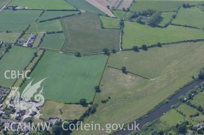
Aerial view of the farmland at Holt next to the River Dee where the tile-works were located

The piece was clearly broken, with a bit of the inscription missing.  Helen returned to Holt a few days later, to show it the to the farmer and to see if the rest of the fragment was lying about in the field, but by then it had all been rotovated – if she hadn’t picked up the brick it probably would have been further damaged. She reckons the gods must have been with her that day!

This was six years before the establishment of the Portable Antiquities Scheme, so after after showing the find to the landowner, who gave Helen permission to keep the object, Helen sent photographs to the British Museum.  The resulting correspondence offers a terrific insight into how an understanding of the significance of the object was reached. It emerged that the fragment of Helen’s brick on which the inscription was made was re-used as a form of notepad to make a quick record.  At first it was thought that the fragment was a tile, but it is more likely to be a piece of lydion or sesquipedalis; these look rather like tiles because they are very thin compared with modern brickwork.  Some of the letters have been sliced off at the far right, but what we are looking at is part of a coherent piece of text, a list with signatures.  It was a small-sized record, containing only a few details.  It measures 32cms, by 30cms, and is around 6mm thick.

Helen hard at work at the Rossett Roman Villa excavation in 2021. Photograph courtesy of Dr Caroline Pudney, University of Chester

The inscription is now recorded in various books and papers contributing to knowledge about Roman activities and everyday life in the Chester area.  Although Holt is just over the Welsh border, the tiles and bricks were created for the Roman occupation in Chester.

Following very fine lunches at Pant Yr Ochain near Gresford and the White Horse in Churton, where we pored over both the artefacts and documents that Helen has assembled, including her original correspondence with Catherine John and Roger Tomlin, we decided to write a post about the inscribed fragment.  Helen has now been investigating the Romans in the Chester area for three decades, and as her knowledge has grown she has excavated as a volunteer at Chester amphitheatre, the Heronbridge Roman settlement, and most recently the Rossett villa.  All the documentation cited here has been provided by Helen.

First, a quick look at the Holt tile-works, which produced the inscribed brick.

The early 20th century discovery of the Holt Tile-works

The Holt brick and tile works site was recognized in the early 1600s when landowner Thomas Crue of Holt Hill suffered repeated damage to his plough and was forced to investigate.  He discovered that his plough was encountering a series of fifty 2ft-tall posts, and his finding found its way into the book Roman Cheshire by W. Thompson Watkins (1886).  This was noted by retired chemist and keen amateur historian Alfred Neobard Palmer who, in 1905, decided to hunt for the remains that Crue had found, accompanied by local vicar Jenkyn Jones, having sought permission from the landowner.  A series of field-walking expeditions followed, uncovering plentiful fragments of Roman brick, roof tile and pottery over an area of some 20 acres.

Fold-out plan of the kilns at Holt, published by Grimes in 1930. (Scanned from my copy of “Holt, Denbighshire”)

Palmer was not an archaeologist, and the task of excavating the site was taken on by Wrexham solicitor and amateur archaeologist Arthur Acton.  Work began in 1907 and continued until 1915.  Although he delivered numerous lectures about the site, Acton never published his work.  Fortunately a portion of his records survived, and he sold the excavation finds to the National Museum of Wales, where William F. Grimes used the data to compile a comprehensive report, complete with site plans, photographs and object illustrations.  Work did not stop there, and during the 1970s Geoffrey Bevan conducted both field walking activities and an excavation, finding Roman material that filled dozens of boxes, which were donated, this time, to the Grosvenor Museum in Chester.  Helen’s field-walking in 1991 added the inscription to the list of important finds, and in 2018 Holt Local History Society commissioned Archaeological Survey West to carry out a geophysical survey of the site, to fix the positions of the known buildings and, with luck, to identify any unexcavated and previously unknown structures.  This demonstrated that the Holt complex was even bigger and more complex than Grimes, via Acton, had been able to determine.  There is, of course, the potential for future field research, and recent work in Farndon, summarized on local historian Mike Royden’s website is beginning to expand the story over to the other side of the Dee.

What was the Holt tile-works like?

Site plan of the Roman tile and pottery work displayed in the Hidden Holt exhibition. Also in the excellent booklet accompanying the exhibition, full details in Sources below. The features shown in blue are unrecorded / unexcavated.  Those in dark brown are the building locations fixed in 2018, and those in paler brown those estimated by Grimes based on Acton’s work.  Click to see a bigger version with fully legible text.  Source: Wrexham Heritage Service, 2021

The 20th Legion, Valeria Victrix, of the Roman army, was stationed at Chester, Roman Deva, from AD87, and the Holt works appears to have been established shortly afterwards to supply the fort and settlement at the legionary fortress.  Holt’s industrial activities reaching their peak output at around AD135, and began falling out of use in the mid 3rd Century.  The site was clearly a fully integrated operation combining industrial, public and domestic components.

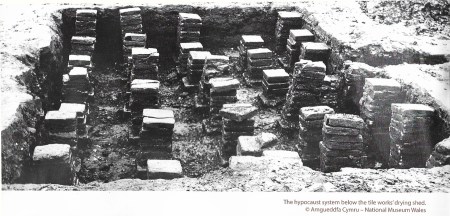
A senior manager had his own house, complete with hypocaust (under-floor central heating), there was a public bath house, a series of kilns for the manufacture of tiles, bricks and pottery, and a barracks that may have housed workers, or alternatively a detachment of the Roman army based at Chester at this time.

The hypocaust below the drying shed. Source: National Museum of Wales

The main kiln plant at Holt, published by William Grimes in 1930.

The kilns formed two main units, a larger (139ft / 52m long, consisting of a row of six kilns) and smaller twin-kiln built on the natural bed-rock.  Each kiln was rectangular and tile-lined with an arched stoke-hole for access.  A round pottery kiln was also located on the edge of the main kiln complex.  The oven floor consisted of a raised floor of tiles plastered with clay that were pierced with holes that acted as vents.  The drying shed was provided with a hypocaust, of the same sort used in villas and bath houses.  These, like the kilns, were stoked and kept hot to ensure that the tiles, pottery and bricks were dried through after firing.

Map marked by Helen to show the approximate findspot of the inscribed fragment

All of the output manufactured at the works was sent by boat downriver to Chester on the river Dee.  It provided direct access to Chester, 12 miles / 19km away, passing the civic settlement at Heronbridge.  The generally flat environment meant that building of roads, where needed, was not exceptionally laborious.
—–

Corresponding about the tile in 1991

The imposing facade of the British Museum. Source: Wikimedia Commons by Paasikivi

Helen wrote to the British Museum in April 1991 describing how she had found the fragment, and enclosing a high resolution photo in which the inscription could be seen clearly.  The first person to reply to Helen’s letter to the British Museum was Catherine Johns F.S.A., at the time Curator of Roman Britain in the Department of Prehistoric and Romano-British Antiquities in the British Museum in London.  In a letter dated 18th June 1991, Catherine Johns begins “Thank you for your letter and the excellent photographs and drawing of the inscribed tile from Holt in your possession.  This is an interesting and important find.”  She goes on to explain that the inscription is in cursive Latin, “that it is to say, it is handwriting rather than formal lettering.”  She was unable to translate the text, which is a specialist task, and sent it to Dr Roger Tomlin of Wolfson College, University of Oxford.  She warned Helen that the fragmentary nature of the text might impede translation.  She finished by suggesting that Helen might consider presenting the piece to the National Museum of Wales, where most of the Holt material excavated in the early 20th century is held.

Helen then received a letter dated 25th June 1991, only a week after the letter written by Catherine Johns, from Dr Roger Tomlin.  Dr Tomlin explained that it was by no means straightforward to decipher and transcribe the fragment, partly because of the several examples of handwriting inscribed, and the fact that it was clearly incomplete.  He suggested that this was a record of expenses, with the star symbol indicating the unit of payment in denarii, and that several individuals were involved. He referred to the inscribed brick as “a welcome addition” to the corpus of Roman inscriptions in Britain. In a later letter, dated 1st July 1991, he thanked Helen for offering to take the the object to him in Oxford, for translation, whilst on a family break, and expressed the hope to meet up with Helen to discuss it.  He suggested that the fragment was probably part of a lydion (or sesquipedalis), rather than a tile, a brick used for bonding-courses.  When Helen met Dr Tomlin for coffee, he departed on his bicycle, in typical Oxford style, with the inscription propped up in the bicycle’s basket.  ———

The inscription

The same photo of the inscribed tile found by Helen Anderson in Holt in 1996 as above, shown again so that you can review the cursive text Copyright Helen Anderson

The brick was inscribed in the still-soft surface of the wet clay before firing.  The translation of the inscription by Dr Tomlin is a great example of the sort of scholarship and academic detective work that go into understanding a single object.  The inscription was abbreviated, typical for this sort of note, where space was limited and standardized abbreviations were recognizable to all.  As already noted, the slab was broken, possibly by ploughing, so parts of the inscription are missing, but this apparently presented few problems for Dr Roger Tomlin.

Just by looking at it, you can see that there is more than one person’s handwriting, and that’s because each person wrote his own signature.  All three were men, named  1) Junius, 2) Maternus and 3) Bellettus.  The final s is missing in each case due to the break.  In the official transcription below, Tomlin has completed words where he knows them.  The slab is a record of expenses they had incurred, but does not say how they were incurred.  Junius was paid at least 4 denarii, probably more, but the break carried the other details away.

Notes about the inscription on the left, on the back of the photo above, followed ultimately by the publication of the inscription in Tomlin 2018, p.290

Front cover of Tomlin’s 2018 “Britannia Romana. Roman Inscriptions and Roman Britain.” Oxbow Books (see Sources below)

Dr Tomlin wrote about the inscription in the journal Britannia, vol.26, 1995, p.387, where it is numbered no.28 (and Helen’s role in the discovery is referenced in the footnotes).  It was later included in Tomlin’s comprehensive Britannia Romana, published in 2018, which lists over 400 epigraphic inscriptions from Roman Britain.  The inscription is listed on page 290 as number 11.14.  Dr Tomlin observed that the three men listed were probably legionaries (although he does not rule out in the 1995 publication that they may have been auxiliaries).  He says that two of the three names were commonplace Roman names, and the third, Bellettus, may have been a variant on the name Bellicus, which he describes as “popular in Celtic-speaking provinces.”  All three signed their own names, meaning that they were literate.

Tomlin is particularly interested in the word sumtuaria, which is missing its p, and is the plural of the noun sumptuarium.  The word is very rare, with the only example known by Tomlin appearing on a legionary pay-sheet in Masada, Israel, where it refers to food expenses.  Tomlin speculates that this was a record of expenses that were to be reimbursed by headquarters at a later date, but he does question how this was supposed to work when the record took the form of a brick (which, after all, could not be divided between the three men!)

Roman soldier’s payslip from Masada, Israel. Source: Arkeonews.net

This find, recording something of the lives of three men who lived in Roman Holt, has something of the air of the Vindolanda tablets.  The thin leaves of wood used at Vindolanda on Hadrian’s Wall recorded many aspects of everyday life, also written in cursive.  A selection of them are on display in London’s British Museum.  One of them had a similar content to the Holt example, showing a list of people who owe money.  Although it is incomplete and undated, it was possible to identify Vitalis the balniator or bath house keeper and Tagomas, one of a number of cavalrymen from northern Spain who appear on the list (also mentioning the latter’s contubernalis, or unofficial wife).

Text from vindolanda showing a list of people who owe money. Source: Vindolanda.com

————–

Publications mentioning the brick

The inscription became something of an emblem of local Roman social history, being referred to not only in academic publication, but also heritage newsletters and leaflets in Chester.  Dr Tomlin suggested that it be included on the Roman Inscriptions of Britain website, and it has very recently been added to the site here, where it has been given the identifier Brit.26.28.

Here are two examples of publications aimed at the general public, collected by Helen, that mention the find and give a good idea of how it was regarded:

Source: Revealing Cheshire’s Past series: From Farms to Fortress leaflet, page 6 Industrial Activity. Cheshire County Council

Connecting with the past

The inscribed brick in the Grosvenor Museum, Chester. Copyright Helen Anderson

You can see the inscribed fragment today in the Grosvenor Museum in Chester, where it is on display in the ground floor Newstead Roman gallery, thanks to Helen requesting that it be displayed locally rather than in the National Museum of Wales in Cardiff.  Not only would it have been difficult for local people to visit it easily in Cardiff, but the tile-works were directly connected with the legionary fortress in Chester, so this seemed like the perfect home for the inscription.  Generations of local schoolchildren can have their imaginations fired by seeing the handwriting of several different Romans who lived here nearly 2000 years ago.

Helen explains that her own children were so excited and proud of her discovery of this piece of heritage that they persuaded her that it should be on loan to the museum rather than donated.  Her children are now grown up with families of their own, and she has since donated it outright, deciding that it’s a piece of history that belongs to everyone.

If anyone wants to chat with Helen about the find, you can contact her via Twitter: @Helenus_.  You can also contact Andie on the Contacts Page, via Twitter @BasedInChurton, or leave a comment (the Leave a Reply link is immediately under the title of the post).

Other posts on this blog about Roman Chester and Holt can be found here.
———-

Final Comments

The object that Helen found in a field in Holt, during a short window between when turf was removed and new grass sown, has multiple identities.  Archaeologically and historically, it is one of a number of records of Roman Britain that together provide insights into Roman settlement and industry and particularly contribute to the narrative about the Holt tile-works.  At another level it is both a clue about record keeping in Roman Holt, and an ephemeral glimpse into the everyday life of three literate Roman men who were working at the tile-works and were claiming expenses.  Today, as well being a significant part of the Roman display in the Grosvenor Museum in Chester, it has made a claim for a position in Helen’s own family history.  Not a bad set of achievements for one inscribed object found lost in a field.  One wonders if the three soldiers ever did receive their expenses?———————

Sources:

Letters (in the private archive of Helen Anderson)

From Catherine Johns, Curator, Department of Prehistoric and Romano-British Antiquities, British Museum. To Helen Anderson, dated 18th June 1991

From Dr Roger Tomlin, Wolfson College, University of Oxford.  To Helen Anderson, dated 25th June 1991

From Dr Roger Tomlin, Wolfson College, University of Oxford.  To Helen Anderson, dated 10th July 1991

Books and papers:

Grimes, W.F. 1930.  Holt, Denbighshire:  Twentieth Legion at Castle Lyons.  Y Cymmrodor.  Society of Cymmrodorion.

Tomlin, R.S.O. 1995. 11.14 Holt (? Bovium), in (eds.) B. C. Burnham, L. J. F. Keppie, A. S. Esmonde Cleary, M. W. C. Hassall, and R. S. O. Tomlin Roman Britain in 1994. Britannia, Vol. 26 (1995), p. 325-390

Tomlin, R.S.O. 2018.  Britannia Romana. Roman Inscriptions and Roman Britain. Oxbow Books (Chapter 11, no.14, p.290-1)

Leaflets and newsletters:

The Past Uncovered, Autumn 1996
http://www.cheshirearchaeology.org.uk/wp-content/uploads/The-Past-Uncovered-Autumn-1996.pdf

Revealing Cheshire’s Past series: From Farms to Fortress leaflet, page 6 Industrial Activity.  Cheshire County Council

Holt: Legacy of the Legions, available from the museum, or can be downloaded.
http://old.wrexham.gov.uk/assets/pdfs/heritage/holt_castle/holt_legacy.pdf

Websites:

Coflein
Holt Roman Site NPRN 307201
https://coflein.gov.uk/en/site/307201?term=holt&pg=2

National Museum of Wales
Request for Information – Freedom of Information Request Relating to Collections – Reference 17-002, 14th February 2017
amgueddfa.cymru/media/41203/response-web-17-002.pdf

Roman Inscriptions of Britain Online
https://romaninscriptionsofbritain.org/
The Holt inscribed brick now has its own page at:
https://romaninscriptionsofbritain.org/inscriptions/Brit.26.28

Vindolanda Charitable Trust
Writing Tablets
https://www.vindolanda.com/blog/fact-file-writing-tablets

Vindolanda Tablets Online
http://vindolanda.csad.ox.ac.uk/


Day trip: Flint Castle – Edward I’s first permanent Welsh foothold

Northwest “garrison” tower at far left, with the big detached southeast “Great” tower in the middle and the northeast “Eagle” tower at far right.  Out of sight, opposite the Great Tower, is the southwest “Prison” tower

A visit to Flint Castle is not really a day trip if your starting point is the Chester-Wrexham area because it’s only about half an hour away, but because we started out quite late, and decided to combine it with a visit to Basingwerk Abbey in Holywell (a 10 minute drive from Flint), and had a long, lazy coffee in the sun, it did turn into something of a day trip.  If you are into fascinating ruins, I recommend both Flint Castle and Basingwerk, particularly as they are such a short distance from one another and overlap chronologically.  Basingwerk Abbey was founded in 1132 and closed in 1535, so its inhabitants would have seen the first construction of Flint Castle.  I’ll be talking about Basingwerk on another occasion.

As Edward began his castle building extravaganza, Llywelyn at last paid homage to the king of England, sitting to the left of the king’s throne, with Alexander of Scotland at the king’s right.

I have already posted the background story to Edward I’s castle building programme in northeast Wales, describing how different generations of Llywelyn the Great’s descendants clashed with England and the Marcher lords in a fight for territory and prestige in Wales.  I have not repeated any of that here, so if you would like the background information, do have a look at my earlier post.

Flint Castle is right on edge of the river Dee estuary, with beautiful  views across to the Wirral, and even though it is on the edge of a busy town with somewhat chaotic traffic, the castle itself is set back from a quiet housing area and stands apart even from that.  Although the river has silted up in front of the castle today, when it was built, the river flowed up to the castle itself.  It has a sense of isolation and peace about it and is a lovely place to visit, and can be combined with sections of the Wales Coast Path.  See my notes about visiting the castle at the end of the post, together with maps.

The Who, When and Why of Flint Castle

Artist reconstruction of the southeast and northeast towers of Flint Castle by A. Hook. Source: Ancient and Medieval Architecture

When Henry III died in 1272, Edward was on his way home from an underwhelming crusade, having narrowly survived an assassination attempt, and he took his time to return to England.  He was not crowned until 1274.

Henry III and Edward had been troubled throughout Henry’s reign with rebellions in Wales, masterminded by Llywelyn ap Gruffud, known as Llywelyn the Last.  Several treaties had failed to achieve long term peace, and although the Treaty of Montgomery of 1267 looked as though it might hold, Llywelyn ap Gruffud was labelled an outlaw in 1276, and war was declared in 1277.  A peace was brokered, but although Edward had every reason to believe that the treaty might secure peace between England and Wales, he began to build a series of castles in northeast Wales, beginning at Flint in 1277 and rolling out along the coastlines throughout the next two decades.

Why here? The location of Flint Castle

Strategic importance of the castle
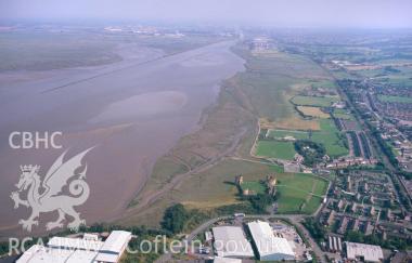
View down the Dee estuary towards Chester showing Flint Castle in the foreground. The build-up of marshland is a recent phenomenon. In the 13th century, the castle was right on the edge of the river, accessible by boat.  Source: Coflein

The unoccupied site for Flint Castle was chosen for its excellent views for miles around, and the slab of bedrock on the edge of the estuary, on which the castle would be built.  Although the castle was sited on a floodplain rather than on a more traditional hill, its location on the Dee floodplain still provided clear lines of sight in all directions.  It would be impossible to sneak up on Flint Castle unless it was foggy.  With tall towers on all four corners, any approach by land or water would be easy to spot, and the town that Edward had planned from the beginning sat on the landward side of the castle, preventing any large-scale onslaught from going unnoticed.

Map of the Welsh Cantrefi showing the location of Flint Castle. Source: Wikipedia.

Although Flint was in English hands in the heart of Llywelyn’s former territory, it was only a day’s march from Chester, one of the great earldoms along the Welsh border.  The castle could be supplied with food and other essentials from Chester by boat, and the estuary provided a potential, although not terribly reliable route of escape, should it be needed.  In addition, a small garrison was maintained at Ness on the Wirral, opposite the site of Flint Castle. When the tide was out, it is said that the river between Flint and Ness could be forded which, if true, would have been a significant logistical advantage.  Most importantly, Flint Castle was a stepping stone into Wales, allowing Edward to build his series of castles one day’s march from one another.  This simple linear network, which could be supported by the sea, began to enclose Gwynedd, particularly as Edward and his magnates began to repair or rebuild Welsh castles that they had defeated.

Castles under siege were always at risk from running out of supplies, but the potential of being restocked from the sea was one form of additional security, and the castle had two wells, one in the centre of the inner ward, and one in the detached southeast tower.

Economic potential of the area

Flint Castle northwest corner

Although Flint Castle was a military installation, Edward intended for it to have a town accompanying it, to take advantage of the area’s natural resources.  A new town would need to attract inhabitants, and as well as incentives, the land itself would need to be able to support the town.

Although there was no settlement at Flint, which was named by either Edward or one of his entourage, it would be wrong to think of the land along the estuary as deserted when the castle was first thought up in 1277.  As far back as the Domseday survey of 1086 the nearby hamlet Atis Cross had a church, a corn mill and a a hide of land, something in the range of 120 acres, belonging to Hugh Lupus of Chester, and there was a lead smelting works here.  Nearby Coleshill (Cwynsyllt) was also mentioned in the Domesday book, and Hen Blâs motte and bailey castle at Bagillt, just over a mile away, which lies within the township of Coleshill Fawr, may have served as the llys (court) for the commote of Coleshill.  Archaeological excavations in the mid 1950s concluded that the castle was replaced by a fortified manor house in the early 13th century, which was in turn abandoned in the late 14th century.  In 1132 the abbey of Basingwerk was built here, and in the 13th century it had water mills and a nearby windmill.  This was potentially a prime area for water mills, as water dropped at speed from the hills towards the Dee, ideal for turning water wheels for processing grain or sheep’s wool.  The area was also suitable for agrarian development, sharing with Anglesey a lowland, fertile location that could be cleared for fields and farmed.

The designer and the design 

1919 plan of the castle grounds that were passed into state care, showing all four towers, the inner keep, the well and the remains of the connecting walls.  Only part of the outer keep is preserved.  The same area  remains under Cadw guardianship today. Source: Coflein

Although much of the castle was deliberately torn down following the civil war in the 16th century to prevent re-use, many of the key features are still visible on the ground.  Castle architecture has some basic requirements that are shared by all castles, but Flint itself showed a number of innovations that make it stand out today. Most of Edward I’s castles in Wales were designed primarily by Master James of St George, but Flint Castle was the brainchild of Richard L’Engenour (d.1315), a wealthy resident of Chester, an architect, master mason and military engineer, the owner of three farms in the Chester area, who in 1304 became Mayor of Chester.  It is probable that Edward’s input is reflected in features of the castle that resemble the castle of Aigues-Mort from which Edward left on crusade in 1270.

The wide open site placed few constraints on its designers and builders.  The castle has a number of notable features, including a double moat and the massive offset donjon, that were innovations in British castle building.  Although Flint began with the castle, a town was always part of Edward’s plan for Flint, so the layout of castle and town were conceived of together.

The castle comprised an inner ward (or bailey) and an outer ward, separated by a moat and drawbridge.  The outer ward protected the main gate into the castle and acted as an interface between the inner ward and the outside world.  It was shaped rather like a funnel, allowing access via a single gatehouse into what was effectively a holding area, narrowing into a path that connected it to a gate into the inner ward, which was overseen by the battlements and by the southwest and southeast towers.  It would have had buildings to house and feed troops stationed there, together with stables for horses and a gaol for holding prisoners.

The rectangular inner ward was made up of round towers built into the walls on three corners, and a detached round tower on the south-eastern corner.  Sturdy curtain walling connected all four towers, with the detached tower joined to the inner keep by a footbridge.  Some foundations remain within the inner ward, plus the all-important well.  On the day that I visited in mid June, the water of the well in the inner ward was clearly visible at about 5ft (152cm) below the ground surface.  Buildings within the inner keep would have included a bakehouse, brewhouse, kitchen, chapel and a hall.  Both wells, the one in the inner ward and the one in the donjon, were fed by the freshwater Swinchiard Brook.  Uniquely, the castle had two moats.  An inner moat protected the main castle and an outer moat protecting access from the town.

The southwest tower and a stretch of the curtain wall.

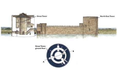
Each of the towers was different.  Although all had spiral staircases leading to battlements for defence, each had its own function.  The southwest tower is, according to Vicky Perfect, recorded in the payroll as the Prison Tower, so may have served as a gaol before a more formal building was added to the outer ward.  It originally had three storeys.  The basement, where prisoners were presumably held, had no steps, which would certainly have frustrated attempts at escape.  The northwest tower, also known as the Garrison Tower, had four points of access, which was useful for deploying troops to the battlements in a hurry, and its basement was probably the store for weaponry.  The northeast, Eagle Tower, was three storeys high, with a basement that was accessed via a trapdoor.  Guests and servants were housed here, and there was a fireplace on the second floor with a chimney up on to the battlements.  A spiral staircase ran up one side.  The potentially standalone southeast Great Tower (also known as the castle keep or donjon), is of particular interest.  Its isolation from the rest of the castle was an additional form of security against any successful incursion, accessible only via a drawbridge, now replaced by a permanent bridge. Sitting within its own portion of moat, it is unique in Britain.  It is a truly massive piece of architecture, about 20ms in diameter, was accessible only on the drawbridge, and contained a central space some 6m diameter.  It was several storeys high.
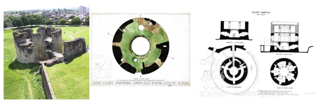
Southeast Great Tower, donjon or keep.  In the centre and on the right, images sourced from Coflein

The donjon or southeast Great Tower

On an everyday basis the Great Tower was the home of the Constable, but also housed the king’s chamber, which was completed in 1286.  The walls of the keep were 7 meters thick at ground floor level, but were still 5 meters thick at upper levels.  To add to its independence from the rest of the castle, and to provide the king with some privacy when he was in residence, it was provided by its own well.  Holes in the floors above it allowed water to be drawn rather than carried, and a wooden wheel was fitted to raise and lower the pail.  It was also provided with garderobes (toilets) and its own chapel.  Its basement, shown right, had a barrel-vaulted ceiling, limewashed to provide reflective light, but also illuminated by torches.  At times of siege, livestock could be moved into the tower to provide supplies on the hoof.

A watergate was built into the north wall, with steps down to the river frontage.   This was for loading and unloading boats directly into the castle.  A smaller watergate was also built into the donjon, again reflecting its design as a standalone unit.

Building the castle 

The first stage in the construction of the castle was to clear an overland route to Chester.  Although the castle could be supplied by boat, there was no road to Flint from Chester. The tidal character of the river meant that the castle could only be reached at high tides, so an overland route was vital.  More immediately Edward was unwilling to run the risk of penetrating the alien countryside where he could be attacked by those with superior local knowledge.  The road allowed him to travel with realistic protection to his new castle, and to enable his army advance unhindered along the Welsh coastline. A road was carved out of the densely vegetated coastal landscape.  It took 10 days to clear the route to Flint, and from there the castle was linked with routes to Rhuddlan, Degannwy and eventually to Conwy.

The next step was to dig a deep ditch around the chosen site at Flint to protect builders and visitors alike, which took three weeks.  The castle was to be built on bedrock, which gave it a solid base on the otherwise soft floodplain.

View from Flint Castle across the estuary and the River Dee to the Wirral

Wood for scaffolding, lifting equipment and for the defences that would surround the planned town was sourced mainly from the Forest of Toxteth (now part of Liverpool).  The fill of the walls of the castle was built mainly of yellow sandstone, much of which Vicky Prefect says was sourced from Ness on the Wirral, opposite, across the estuary, and other locations on the edge of the Wirral.  Ness could be reached over the sands when the tide was out by fording the river, but stone could also be brought in by boat.  Edward kept a small garrison at Ness.  Other sandstone was available locally, along with other natural resources including lead ore, lime for mortar and white limewash for walls (both lead and lime available from Halkyn Mountain).  Although yellow sandstone dominated, red sandstones were employed for some parts of the outer and inner walls, some of which came from Burton Point, a bit upriver from Ness, with the inner space between them filled with mixed rubble, including stones from the beach and broken building materials.

Many of the original payrolls for the construction of the castle have survived, meaning that details of names, home towns, job roles, and salaries of the workers who built the castle have survived.  Just as the king could demand that his noble subjects should provide men for his armies, he could assemble workforces of specialist craftsmen from across England, whether they wanted to go or not.  The building site and the craftsmen were protected by armed forces. This formula worked so well at Flint that the same model, and many of the same craftsmen, were used at the subsequent castles.  Here’s Vicky Perfect’s description of the first weeks of work in the summer of 1277:

The workforces were placed under the control of various knights, and split into groups under their twenty men (foremen). . . . In week one of the the build a total of 1858 men were involved in the first stage of the building of the castle.  Most were dykers who were required to help prevent the water from filling in the newly dug foundations.  The first order of 10,000 sandstone blocks was placed at the quarry of Ness prior to 25th July 1277.  Large numbers of carpenters and wood cutters were employed, some working in the forest s at Toxteth cutting the timber and building the 250 rafts needed to transport the stone across the water.  Many others were working on site, constructing the stockade required to keep the men safe and making the lifting machinery to move the sandstone blocks into place.  There were also numerous masons, working the stones delivered from Ness Quarry.  Smiths were employed to make and mend the metal tools required for the project.

By week two, the workforce had increased dramatically to 2,911, indicating the urgency of making the site safe.  More specialist workers were brought to the site, such as Carbonarii (miners) to mine the coal to fuel the smith’s fires.  The number of dykers working on the site doubled, including a group from Holland.

The well in the Great Tower.

The rest of that chapter is worth reading in its entirety, providing some fascinating facts and figures including lists of some of the workers, their trade, the number of them employed and how much they were paid.  For example, in the first two weeks, the castle employed dykers, smiths, carpenters, masons, woodcutters, miners, cinder carriers, masons and constables, paid from 2d to 8d a day, the latter reserved for the specialist Dutch dykers.  Other specialists were brought in as work progressed.  John le Blund, for example, was brought from London and paid 19 shillings for dressing stones for the well in the Great Tower.

The castle was not completed until the mid 1280s, by which time it had been painted with  white limewash, and the towers, which had been provided with temporary roofs of thatch, were now provided with lead roofing.  In 1302, following storm damage, lime was brought to repair the castle walls.  In 1304, wood from Ewloe produced 60 boards, 12,000 pieces of wood for tiling, 1000 lathes and four louvres for repairs so kitchen and stabling.

The town

John Speed early 17th century map of Flint. Source: Coflein. Click to enlarge.

An accompanying town, (or “implanted bastide”) was part of Edward’s original plan for the castle.  The idea of establishing defended new towns around castles in hostile territory came from Gascony, where Edward had already founded a number of new defended towns.  Pioneer settlers were granted considerable commercial privileges as incentives, and were expected to help defend the town should it come under attack.  These new towns reinforced the network of castles with economic as well as military foundations, and the enclaves of English commerce also introduced English urban traditions within rural Wales.  Flint and Rhuddlan were two of the earliest examples. 

Writing in 1924, Patrick Abercrombie commented that “There is no town in this country that is of greater interest to the student of Town Planning than Flint. Laid out by Edward I, in 1277 as an appendage to his mighty castle, it has preserved its mediaeval plan almost intact. Like most artificially planted communities, there was no fundamental human need in this place for a town, which accordingly grown in the past little beyond its original size.”  It is a fascinating idea that new towns, built from scratch, arrived with the Normans.  According to Francis Pryor, a total of 172 of these towns are known in England and 84 in Wales, and Edward was the “last great instigator” of the new towns.  As well as the layout of the towns, functional considerations were also important, and Edward believed that to support markets, good road links were vital.  Communications became one of his mantras, vital for a peripatetic king and court, but also for the movement of troops and the commercial viability of new settlements. 

Excavations in 2015 explored what are thought to be part of the town’s defences. Source: BBC News

An indication that the beginnings of the town, which  were already established by early in 1278, was a proclamation of a weekly market each Thursday and an annual fair.  Edward decreed that the burgesses of Flint should hold a market on Thursday of each week, and an annual week-long fair at the time of the Pentecost (50 days after Easter Sunday).  The castle constable was to serve as mayor, one of Edward’s own brothers was installed as chaplain at the castle, and agents were appointed to rent out plots of land to any pioneering English inhabitants who were prepared to chance their luck even though the defences were incomplete.  To encourage take-up, in 1282 these agents offered plots in the town free of rental for ten years, followed by a reduced rate in subsequent years, and residents came under English, rather than Welsh jurisdiction.  Burgesses (property-owning merchants) were exempt from the payment of tolls. In 1284 the town received its first royal charter, which conferred full English-style free borough privileges.  The settlers had their own guild and courts.  Conveyances of property suggest that many of the settlers were from Cheshire, who took advantage of the provision of land in the royal demesne and forests.  Others probably came from Shropshire.  A town mill was constructed, and permission was granted for another, which incurred an annual rate of ten pounds. Even with these benefits, it was obviously an uphill struggle to attract residents at first, in spite of the fact that by 1300 much available land in England was in use and the expansion of population during the 13th century meant that it was becoming increasingly difficult to find land.   By 1292, however, the town had taken off and there were 74 burgesses registered for tax in Flint.

The main source of information for the town’s layout is John Speed’s sketch of 1610, shown above.  The Norman new towns were built as grids.  The maps show that Flint still preserved its Medieval layout, and that it was one of the most symmetrical known, with a very precise underlying geometry.  Four parallel roads ran perpendicular to the river, whilst Edward’s coastal road passed through the middle of the town parallel to the river.  Whether the dog-leg was original or developed between the 1280s and Speed’s map of 1610 is unknown.  One of the four parallel roads, along the route of modern Church Street, connects the entrance to the town with the entrance to the outer ward, passing in front of the Church of St Mary’s and the town square.
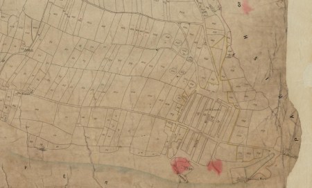
Tithe map of Flint area, showing the original Medieval field systems. Flint castle is handily under the left-hand red blotch, and the grid layout of the town is easily seen, as are the neatly arranged fields.  Source: People’s Collection Wales

The economy of most of north Wales was based on livestock herding. Nearby Basingwerk Abbey depended for some of its locally derived income on its 53 heads of cattle and its 2000-strong herd sheep.  However, some lowland areas could be developed for mixed farming.  Anglesey was “the bread basket of Wales,” and the river lowlands at Flint were potentially ideal for agrarian land use.  In order for agriculture to underpin the activities of the settlers at Flint, clearance of neighbouring land took place to create new fields, the outlines of which survive, remarkably, on the 1839  tithe map, shown above.  This shows Flint town’s four parallel roads immediately in front of the castle, but extended on either side beyond the bissecting coast road.   The surrounding land is similarly divided up on a grid pattern of long, thin fields.  Although residential, commercial and industrial growth have obliterated much of this, some of it still survives to the south of Flint town.

Access from the outer ward into the inner ward

Writing about the design of Flint Castle’s town, Caroline Shillaber concludes that “Viewed in historical perspective, Edward I appears as the forerunner of British planners who regard the creation of new towns as a function of national government, who locate and plan the towns to serve an overall administrative policy, who lay out the towns  in accordance with the needs of the people, and who devise economic conditions conducive to their growth and development.”  Some areas were riskier than others, however, as the settlers in Flint discovered in 1294 when renewed hostilities between England and Wales resulted in the town being burned to the ground.  Even though residents received compensation and the town was rebuilt, it must have been a daunting thought to stay in a town where its supposed protectors were willing to burn it down if the need presented itself.

A tax assessment of the town had been made in 1293, naming residents like Adam the carter, Benedict the miner, Godfrey the carpenter and Nicholas the smith.  The assessment recorded 76 households.  Only five of those named were Welsh, like Madog ap Iorwerth and Einion Cragh, indicating that even in an English enfranchisement Welsh people held property.  Things changed after the town was burned down after 1294, perhaps due to bad feeling about the devastation of the town thanks to Welsh hostilities.  This is reflected in a petition of 1297, written when the town was still being rebuilt.  The English burgesses of Flint complained that in an English town, Welsh individuals had “bought land in the town and bake and brew, contrary to their charter and custom,” although there was actually nothing in the 1284 town charter to restrict the nationality of residents. 

Matthew Stevens gives an account of an Englishman named Richard Slepe who had been in Flint town from its inception, and had remained after the town had been burned down.  His daughter Agnes had married a Welsh man, Adda ap Einion.  When Richard died in 1327, Agnes and her husband inherited Richard’s properties, but because Adda was Welsh, they were confiscated by local officials.  They appealed the decision but were turned down.  Enfranchised Welsh towns, occupied by the English, made no concessions to a mixed-nationality marriage, a situation that continued until the 1536 Act of Union giving Welsh nationals equal rights to English.  

The castle under attack during the reign of Edward I

In March 1282 Llywelyn’s brother Daffyd launched a ferocious assault on Hawarden Castle, and this was followed by further attacks on Flint and Rhuddland castles, in which Llywelyn appears to have participated.  Attempts by Archbishop Pecham to negotiate a peace failed, and Edward through everything he had at the brothers, as described on my previous post.  Llywelyn was killed in battle in December 1282, and Dafydd was captured and put to death the following year.  The Flint area, including Basingwerk Abbey, was trampled underfoot, but Basingwerk was given significant compensation and Flint Castle was repaired and construction work completed by 1284.

As mentioned above, in September 1294, those who had been lured to settle in Flint met the dangers of living in the shadow of a strategic military facility head-on when the constable of the castle, William de la Leye, ordered that the town be set on fire to prevent forces led by Madog ap Llywelyn from using it as a protective screen.  Madog ap Llywelyn, one of Llywelyn the Last’s more remote cousins, considered himself to be a successor of Llywelyn and made a bid for power, supported by other Welsh landowners.  Some of them joined Madog on an opportunistic basis, with territorial claims in mind, but all of those who retaliated at this time acted in response to a massive tax demand, and a culling of Welsh men to supply troops for his activities in Gascony. Attacks were co-ordinated and took place at castles both built and appropriated by Edward, at Aberystwyth, Builth, Castell-y-Bere, Denbigh, Criccieth, Harlech, Caernarfon, Morlais, Flint and Rhuddlan.  It was a serious rebellion, and it demanded a serious response.  Edward immediately diverted the troops waiting to ship out to Gascony, sending them instead to Wales, where they advanced from three bases. Madog’s revolt was put down after some delay in March 1295, with Madog surrendering in July.  Edward compensated seventy five burgesses with £521.00, and the buildings were all re-built, but life next to a strategic outpost of an invading nation cannot have been particularly reassuring.  

View along the Dee towards the west from the inner ward

Edward I died in July 1307 at the age of 68 and was succeeded by his son Edward II (April 1284 – September 1327), who had been declared Prince of Wales in 1301.  Edward’s reign was colossally unpopular and he was forced to abdicate in January 1327 in favour of his 14-year-old son, Edward III. Following the quashing of the rebellion of Madog, North  Wales remained more or less at peace until the rebellion of Owain Glyndŵr under the reign of Henry IV in 1400.  Flint Castle continued to be strategically important, and retained a garrison.  The town, protected by the castle, was a financial and administrative centre during the 14th and 15th centuries, meaning that even in times of peace the castle retained its importance and was accordingly well maintained.  Future archaeological excavations may provide information about the original town, both before and after the fire.

Back in the wars after Edward I

Richard II 

Richard II at his coronation. Source: Wikipedia

In terms of great events after Edward, Flint Castle’s next claim to fame was as the venue for the abdication of Richard II (1367-1400) in favour of Henry Bolingbroke, who became Henry IV.  Richard II was the grandson of Edward III, and on the death of his own father, Edward the Black Prince, became heir to the throne, succeeding in 1377 at the age of 10.  He was deposed in 1399.  Flint Castle itself had had nothing to do with Richard II’s career up until that point.  Richard’s regency was managed by a number of councils.  One of his most important advisors was his uncle John of Gaunt. 

The regency councils saw England through the continuing eruptions of the Hundred Years War and the Peasants’ Revolt of 1381, and Richard himself was forced to deal with a number of substantial disruptions, including the threat of invasion from France.  As he came into his own power, Richard’s mistrust for the aristocracy lead him to select both his friends and personal guard with care, causing discontent amongst the powerful aristocracy.  When a group of them took control of the government in 1387, refereed to as the Lords Appellant, Richard was able to reinstate himself, but punished the conspirators with exile or execution.  One of the exiled was his cousin Henry Bolingbroke, son of his advisor John of Gaunt. 

The coronation of Henry IV, from a 15th-century manuscript of Jean Froissart’s Chronicles. Source: Wikipedia

On the death of John of Gaunt, Richard denied Henry Bolingbroke his inheritance, and this was enough to push Henry to open rebellion, landing in Yorkshire in June 1399. Richard II seems to have been very unpopular, and it does not appear to have taken Henry a substantial amount of effort to depose his cousin.  While Richard was in Ireland, Henry moved south.  Richard landed in Wales in July 1399 and entered negotiations with the Earl of Northumberland before surrendering to Henry on 19th August at Flint Castle.  Shakespeare puts these words into Richard’s mouth (Act 3, scene 3):

Cousin, I am too young to be your father,
Though you are old enough to be my heir.
What you will have, I’ll give, and willing too;
For do we must what force will have us do.

Henry Bolingbroke, in Shakespeare’s version, shows all due reverence and offers the king dignity and reverence, but the reality is that Richard was forced to resign in exchange for his life and was forced follow behind Henry to London, where he was incarcerated in the Tower of London.


Owain Glydwr 

Northwest tower

In 1400, a wealthy and London-educated Welsh nobleman was the source of the final great rebellion.  Owain Glyndŵr was the descendent of Llywelyn the Great and the princes of Powys, Owain Glyndŵr (c.1359–c.1415), and had served as a soldier under Richard II revolted against King Henry IV of England, using guerrilla tactics and his knowledge of the terrain to inflict damage on English forces. As with Madog in 1294, his primary grievances were unfair taxation, land disputes, and systematic neglect by the English government.  Owain’s first move was to attack key English castles, including Flint, placing it under siege in 1403.  The burgesses retreated into the castle whilst the town was plundered, inflicting damage that again took substantial time to repair.  Owain inflicted a number of defeats on the English forces with the aid of foreign assistance, and for a few years controlled most of Wales.  He called a parliament in Machynlleth in mid Wales, which was also attended by foreign dignitaries, where he named himself Prince of Wales, presented his plans for an independent Wales, which included building two national universities and the reintroduction of the traditional Welsh legal system.  In the long term, however, even with foreign military aid Owain was unable to compete with England’s superior forces and the king began to regain control of Wales.  Owain Glyndŵr continued to be a thorn in England’s side until 1412, when he disappeared after escaping a siege at Harlech.  He became something of a folk hero and a powerful symbol of Welsh nationalism and heritage.


The English Civil War (1642-1651)

Colonel Roger Mostyn (c.1623-90)

When Charles I acceded to the throne in March 1625, he came into conflict with Parliament from very early in his reign.  Like Henry III, he believed that the king ruled by divine right, and this in turn meant that he was answerable only to God, and not to any earthly authority.  His marriage to a Catholic did not help his popularity.  Constant bickering over religion and funds for Charles’s various projects, none of which Parliament was willing to fund to the king’s satisfaction led to the deterioration of the relationship, and in 1642 the country was torn in two, when civil war broke out.

By this time Flint Castle had been abandoned and was in very poor condition.  It was still, however, located in an excellent strategic position and local landowner Roger Mostyn made the decision to repair the castle and install a garrison as a contribution the Royalist cause.  A useful store for supplies for Chester, the castle changed hands several times during the conflict.  Back under Roger Mostyn, Flint found itself under Parliamentarian siege on 1st June 1646 and held out for nearly three months until all supplies had been exhausted and the garrison under Roger Mostyn surrendered rather than starve.  Although the Parliamentarians allowed them to leave unharmed, they were taking no chances regarding the castle, which was immediately slighted (rendered unusable).

The king was defeated at Rowton Heath, south of Chester, on September 24th 1645.  John Taylor in A Short Relation of a Long Journey, which he wrote in the summer of 1652, painted a thoroughly gloomy picture:.

Surely war hath made it miserable; the sometimes famous castle… is now almost buried in its own ruins, and the town so spoiled that it may truly be said of it, that they never had any  market (in the memory of man). They have no sadler, taylor, weaver, brewer, baker, botcher, or button maker; they have not so much as a signe of an alehouse . . . and this (me thinks) is a pitiful description of a shire town.

Future archaeological excavations may provide information about the original town, both before and after the 1294 fire.

An object of artistic interest

J.M.W.Turner’s painting of Flint Castle. Source: williamturner.org

Although it’s life was over as a military installation, Flint Castle joined other nearby ruined castles and abbeys, like Beeston Castle in West Cheshire and Valle Crucis Abbey near Llangollen, as popular tourist destinations, which were also popular with artists.  The best known of these was J.W.W. Turner (1775-1851), who painted both of the previously mentioned sites, and created a typically atmospheric view of Flint Castle too.  It is fairly typical of Turner’s paintings of this period, produced in the 1830s.  It shows the main subject of Turner’s interest in the background, with contemporary activities in the foreground.  Rather than place his ruins centre stage, Turner usually placed them where they eye was drawn to them, but in much less detail than the activities taking place in his foregrounds.  The man on the right looks towards the castle.  The sun rises at the castle’s side.  A line of blue-grey along the horizon draws the eye from left to right, tying the composition together.  The castle’s silhouette contrasts spectacularly with the yellows, reds, oranges and golds of the rest of the composition.  Everything in the painting draws the eye away from the more detailed and busy foreground to the static silhouette of the the castle’s profile.  Both beautiful and clever.  This was not Turner’s only study of Flint Castle, but it is my favourite.

View of Flint Castle by Richard Reeve 1812. Source:

I also very much like Richard Reeve’s earlier, far more prosaic and much less virtuoso portrait of Flint Castle.  Painted in 1801, instead of Turner’s juxtaposition of past and present, it blends the two, showing everyday life in in harmony with the ruins.  In Reeve’s view, the castle, the the beached boats drawn up on the shore alongside, the cottages in the foreground and the horse and cart driving away all occupy the same time zone without difficulty.  The men pulling in the nets are so accustomed to the castle’s looming presence that it is a mere backdrop to their activities.

Although no-one of Turner’s luminary talent has been drawn to the castle since the 19th Century, probably because of its urban and industrial surroundings, plenty of artists and photographers continue to find inspiration from Flint Castle.

Flint Castle today

Today the castle is a tourist attraction managed by Cadw.  It is beautifully maintained and money has been lavished on creating staircases that give safe access to and within the towers.  The views from both the inner ward and the towers are superb.

There is not much in the way of explanatory signage.  If you want to be informed, it is best to do the reading in advance.  There is a Cadw guidebook that takes in Ewloe castle as well, but it is out of print and difficult to get hold of.  Former mayor of Flint Vicky Perfect has dedicated a small but excellent book to Flint Castle, which is very well researched and written, and includes photographs, illustrations and maps (details of both books are in Sources at the end).

Visiting
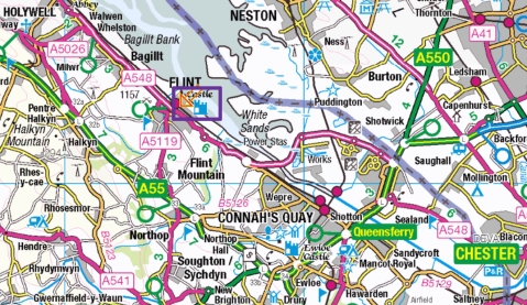
Map showing the location of Flint Castle relative to Chester and Holywell (Basingwerk Abbey, marked as “Abbey” at the top left of this map, on the coast at Holywell, can be combined with Flint Castle for a visit). Source: streetmap.co.uk

You have to watch carefully for the road signs directing you to the castle (little Celtic cross symbols) because they are easy to miss.  Alternatively, as we did, check it on the map first to get an idea of the location and then just rely on GPS (I use the free Google Maps app on my iPhone, which works a treat).  There is a good car park overlooking the castle and estuary, with picnic benches on the grass below.
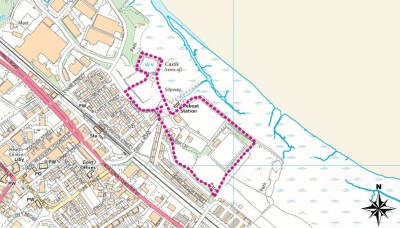
Short walk taking in Flint Castle, and suitable for those with mobility issues, although accessing towers within the castle requires the ability to tackle staircases.  Even without entering the towers, the sense of the castle from within the inner keep is excellent, and the views from the inner keep across the estuary towards the Wirral are lovely.  Source: Flintshire County Council

Flint Castle itself is a bit of a mixed blessing for those with unreliable legs.  One of the best things about Flint Castle is that it is possible to walk up staircases (both original stone ones and bright, modern metal ones), some of which are quite steep.  Although access is on the flat into the outer and inner wards, and the views from the inner ward are lovely, it is difficult to really experience all the components of the castle unless you tackle some stairs.  On the other hand, the walk shown here (from the Flintshire County Council website) shows a walk that includes that castle but could easily be done for those with unwilling legs.

Access to the castle is free, but check the Flint Castle pages on the Cadw website to check if it is closed for certain seasons or specific dates.  The car park is also free of charge.  There was a mobile café van whilst we were there, but there are no other café type facilities on the site.  There is a nice café at Basingwerk Abbey in Holywell if you are combining the two on a single visit to the area.

A section of the Wales Coast, marked with green diamonds, heading west from Flint Castle (marked at left with a white cross on a blue background). Source: Wales Coast Path interactive map

If you like walking, the castle is handily located on the Wales Coast Path, and although the Welsh side of the Dee is characterized by light industry, the views from the Wales Coast Path are across the estuary towards the Wirral.  We’ve not yet done any of the Wales Coast Path in that part of Wales, but the views from the castle argues that it has lots of potential, and I am hoping for sea and marsh birds too.  I cannot state whether or not it is suitable for those with unwilling legs, but it does seem plausible, because it is all on the flat.
asdfasdfa

1726 print of Flint Castle.  Source: Coflein

Sources

Books and papers

As usual, the main sources used are shown in bold.

Note:  Vicky Perfect’s book on the castle (listed below) is great guide to Flint Castle in one convenient publication, with excellent illustrations.  In particular, Chapter 3 “The Building of Flint Castle” makes excellent use of primary sources to provide a fascinating insight into the resources required, the techniques used and the men involved in the construction work (including details of some of their roles and daily pay).

Abercrombie, P. 1924.  Flint.  The Town Planning Review, Vol. 10, No. 4 (Feb., 1924), p.241-244
https://www.jstor.org/stable/40101411

Butlin, R.A. 1978. The Late Middle Ages, c.1350-1500.  In Dodgshon, R.A. and Butlin, R.A. (ed.) An Historical Geography of England and Wales.  Academic Press, p.119-150

Davies, J. 2007 (3rd edition). A History of Wales. Penguin

Dyer, C. 2002.  Making a living in the Middle Ages.  The People of Britain 850-1520.  Yale University Press

Jack, R.I. 1988. H. Wales and the Marches. In Chapter 4, Farming Techniques in Hallam, H.E. (ed.) The Agrarian History of England and Wales, Volume II, 1042-1350. Cambridge University Press, p.412-496

Jenkins, G.H. 2007. A Concise History of Wales. Cambridge University Press

Hume, P. 2020. The Welsh Marcher Lordships. I: Central and North. Logaston Press

Morris, M. 2008. A Great and Terrible King. Edward I and the Forging of Britain. Penguin

Perfect, V. 2012. Flint Castle. The story of Edward I’s first Welsh castle. Alyn Books

Pryor, F.  2010. The Making of the British Landscape.  How we have transformed the land, from prehistory to today.  Allen Lane

Renn, D.F. and Avent, R. 2001 (2nd edition). Flint Castle – Ewloe Castle. Cadw

Rowley, T. 1986. The High Middle Ages, 1200-1500. Routledge and Kegan Paul

Saul, N. 1997. The Oxford Illustrated History of Medieval England. Oxford University Press

Shillaber, C. 1947. Edward I, Builder of Towns. Speculum, Vol. 22, No. 3 (Jul., 1947), p.297-309
https://www.jstor.org/stable/2856866

Stephenson, W. 2019. Medieval Wales c.1050-1332. Centuries of Ambiguity. University of Wales Press

Vening, T. 2012. The Kings and Queens of Wales. Amberley

Walker, D. 1990. Medieval Wales. Cambridge Medieval Textbooks


Websites

Ancient and Medieval Architecture
Flint – Castle (particularly useful for images) (Janusz Michalew)
https://medievalheritage.eu/en/main-page/heritage/wales/flint-castle/

BBC News
Historic Flint Castle defences found under block of flats. June 7th, 2015
https://www.bbc.com/news/uk-wales-north-east-wales-33032562
Flint Castle: History behind castle chosen for sculpture. By Matthew Frank Stevens (Senior Lecturer in History, Swansea University). 1st November 2019
https://www.bbc.co.uk/news/uk-wales-50260758

Cadw
Flint Castle
https://cadw.gov.wales/visit/places-to-visit/flint-castle
Flint.  Understanding Urban Character.
https://www.flintshire.gov.uk/en/PDFFiles/SHARP/Flint-Understanding-Urban-Character-(Cadw-2009).pdf

Clwyd Powys Archaeological Trust
Historic Settlement Survey – Flintshire
https://cpat.org.uk/ycom/flints/flint.pdf

Coflein
Site Record: Flint Castle (with some excellent image and plans)
https://coflein.gov.uk/en/site/94448/

Curious Clwyd
https://www.mythslegendsodditiesnorth-east-wales.co.uk/

Halkyn Mountain
https://www.halkynmountain.co.uk/

Wales Coast Path
Home page
https://www.walescoastpath.gov.uk/?lang=en
Interactive Coast Path Map
https://www.walescoastpath.gov.uk/plan-your-visit/interactive-coast-path-map/?lang=en#


Eaton Hall Gardens Charity Open Days 2022

My father and I booked for the open day on Sunday 26th June.  All tickets have to be booked in advance, both for the gardens and for the train a narrow gauge railway.  We skipped the train option so I don’t know what that experience was like (lots of children, I would imagine) but the gardens were superb, and in some ways unexpected.  Brief comments on practicalities for those considering July or August visits, in terms of parking, suitability for those with mobility issues etc, are at the end of this post.

The Eaton Hall Gardens are open to the public three times this year, the last Sunday in June, July and August, all in aid of three different charities.  If you are intending to go, but have not yet booked a ticket, I suggest you book immediately via EventBrite, as it sells out every year. I missed the chance last year.  The benefiting charities for the 2022 events are Cheshire Young Carers, Cheshire Wildlife Trust and Kidsbank.

We entered via the Belvedere gate just north of the Grosvenor Garden Centre on the old Chester to Wrexham road (the B5445).  It is an ostentatiously long approach to the property.  Just in front of a gigantic obelisk is a checkpoint where you show your tickets.

Young RAF Air Cadets were on hand everywhere to direct traffic and answer questions, and did an absolutely splendid job of keeping the traffic moving.  Once we had followed their directions and parked in a field (but see my notes on disabled access at the end), and walked up towards the estate buildings, you pass through a gate where your tickets are checked again.  Here you are handed a leaflet about the charity being supported, and another highlighting garden features that you might want to visit by head gardener Jan Lomas, with an excellent map on the back showing the locations those features, with  recommended routes between them, which is absolutely necessary if you are not going to miss anything.  You can download my battered copy of the map here if you want to plan your visit in advance.

We were lucky with the weather, because although it was overcast, with only short burst of occasional sunshine, it remained dry, and it was warm.  You can click on any of the photos to see a bigger version.

The description of the gardens on the EventBrite website gives some idea of the treats in store:

Eaton Hall Gardens extend to 88 acres and have been developed over many years by prominent designers, most recently by Lady Arabella Lennox-Boyd. The gardens have a wide variety of planting, including four formal colour-themed rose gardens and grand colour-themed herbaceous borders. There is a newly completed hot border design and a stunning bedding scheme in the Dragon Garden which is not to be missed. Visitors can also enjoy the walled Kitchen Garden, as well as the wildflower garden and the lake walk, where you can take in fabulous views of the Hall and grounds. Finally, the Tea House is filled with roses and herbs and sits perfectly at the end of a short walk past the lake area.

We found all the gardens except the wildflower garden (up a flight of stairs out of the Dragon Garden), and we didn’t do the lake walk simply because it was getting rather late, but looks like a brilliant venue for the picnics that were being carried by more organized visitors.

The first place that we visited was the camellia walk, a long, slender glass corridor lined with camellia bushes.  Although none of the camellias were in flower (they are a spring flowering species), the conservatory building itself was a thing of real beauty, and the sense that it goes on and on without visible end is wonderful.

Nearby are the sheds and the platform for the narrow gauge railway (with open-sided carriages pulled by a steam engine, which used to connect to a Chester-Shropshire railway line siding some 3 miles away).  We walked along a track round the walled kitchen garden towards the courtyard entrance, which is an intriguing little walk, as there is a lovely tree-lined walk towards the kitchen garden, and a couple of quirky buildings, but no signs that it is in use for anything.

The first port of call for most people is the former stable block surrounding a courtyard.  The stable courtyard is open to the public, and there is a horse-drawn carriage display in the light-filled atrium that gives access to it.

The open courtyard itself is laid out with tables and chairs, and is one of the places where refreshments are served in aid of charity (for cash only), and was very congested, but the surrounding buildings were not at all busy.

The former stables themselves, built by Alfred Waterhouse in around 1869, are open.  The saddle horses and harness horses were stabled separately, and there was a harness room and a carriage house too.  There is some information about the horses stabled there and a reconstruction of the stud manager’s office, as well as the family history and exhibition rooms.  You can also, from the stable courtyard, access the bizarre shell grotto and the 1870 Eaton Chapel from the courtyard (stained-glass windows by Frederic James Shields).  Live organ concerts were being played in the chapel, majoring on Johann Sebastian Bach, a lovely, intimate sound in that small space.   

After visiting the courtyard, which is the first place that everyone seems to filter into first, the nearest of the gardens to visit is the walled kitchen garden.

Along one of the walls is a broad border filled with brightly coloured flowers, many of which grow on a massive, upwardly skyrocketing scale.  Within the walls, the beds are divided into squares and rectangles by multiple pathways, many of which are provided with colourful arches.  Some of the beds are defined some defined by short hedges of interlaced apples.  Some of the flowers are exotic and gaudy, others are more humble and subtle, and there is a lively mix of floral displays and vegetables, with lots to see.  The overall impact is one of careful husbandry with a real eye for colour, scale and shape.

asfsdfs
dafdsfs

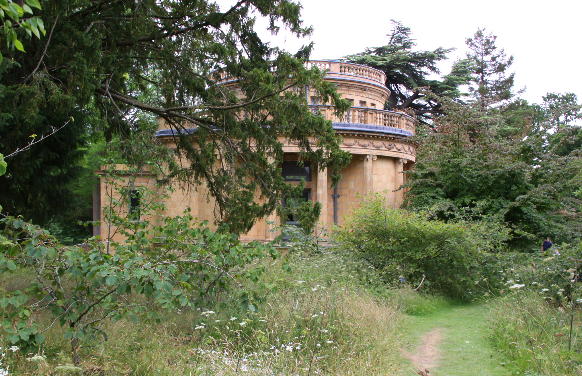
From there we walked down to the Parrot House, a little round building looking rather like a Graeco-Roman temple, but designed to keep tropical birds.  It was built in the 1880s by Alfred Waterhouse and was fitted with heating to create suitable conditions for such birds, but apparently never housed anything more tropical than some budgies.  There were hay bales outside for visitors to sit and watch the band.

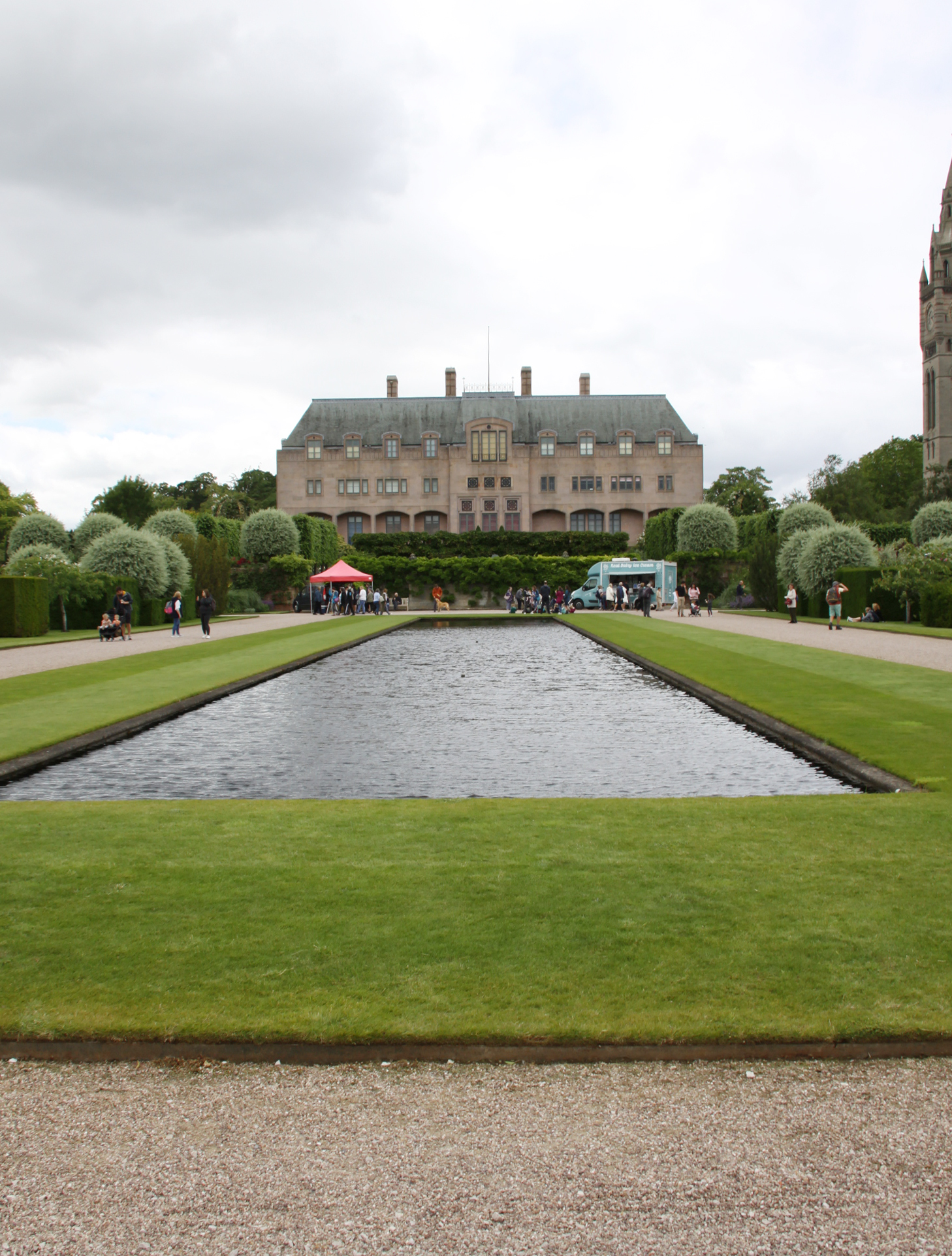
From here it was a short walk to the rose gardens, which sit in front of the Eaton Hall house, offering the first real glimpse of the house and the great clock tower of the neighbouring chapel.  The Country Seat website offers the following very useful potted history of Eaton Hall (not open to the public, but an unavoidable presence).

A Victorian Gothic iteration of Eaton Hall in the late 19th Century. Source: Lost Heritage

The first notable Eaton Hall was designed by William Samwell and built in 1664 but was replaced by a vast Gothic creation by William Porden in 1803, which was then enlarged by William Burn in 1845. This was then replaced by the Victorian Gothic of Alfred Waterhouse in 1870, before the whole edifice was swept away in 1961 as the trustees of the then young Duke couldn’t imagine anyone living in such splendour again. Faced with being a Duke with no seat in his 11,500-acre estate in Cheshire, in 1971 the 5th Duke commissioned a starkly white modernist country house from John Dennys, (who also happened to be the Dukes’ brother-in-law) which was as striking as it was controversial. This was then given a vaguely ‘chateau’ style makeover in 1989 for the 6th Duke, to designs by the Percy Thomas Partnership. So of the five major houses which have been graced with the name Eaton Hall, the current one, though impressive, still doesn’t quite have the gravitas of the others. Perhaps, in time, a future Duke may decide to replace it again.

The current house is an ugly great block of a thing looking not unlike Faengslet prison. I daresay it has more going on in its favour on the inside.  Next to it, rather more endearing in a uniquely Victorian way, is the Eaton Hall chapel clock tower and the chapel itself, behind which is the the stable courtyard.  Although the history of the house is of interest, the visit is all about the gardens, which are excellent.

The gardens are dotted throughout a park that sits above a lake and extends to the east.  Instead of being clustered around the house, as in most houses and estates of this type, the different gardens are dotted around, approached both via metalled surfaces and grass paths mowed through stretches that have been allowed to run wild.

The rose gardens are probably the highlight of the gardens at this time of year, with climbing roses climbing up trellis obelisks and running along heavy rope links.  The twin gardens flank a long rectangular ornamental pond that runs towards the house.  The pond is often shown with fountains, but they were not operating when we visited.

The rose gardens, supplemented by other species to complement the colours of different sections, form part of a remarkable of a set of terraces.  The top terrace, not accessible to the public, is on the level of the house.  The rose gardens are next down, and below this is the lioness and kudu pond, which in turn overlooks the slope down to the lake, which is fed by the River Dee.

The rose gardens and the pond are flanked by wooden arches connected with thick ropes, and both the arches and the connecting ropes support white and palest pink roses.

On each side of the pond are two square rose gardens, separated by yew hedges, cleverly offset so that one garden cannot be seen from the next, giving the impression of being the entrance to a maze.  Each of these rose gardens has a central focal point, a circular path, and four beds, each with a massive obelisk in its corner.  Each of the gardens is colour-themed.  One, for example, is blue and yellow, whilst another is pure white.  The roses are certainly the dominant flower, but they are supported by penstemons, clematis, geraniums and various other species that help to create a mass of different textures and shapes.

asfsfdfsd
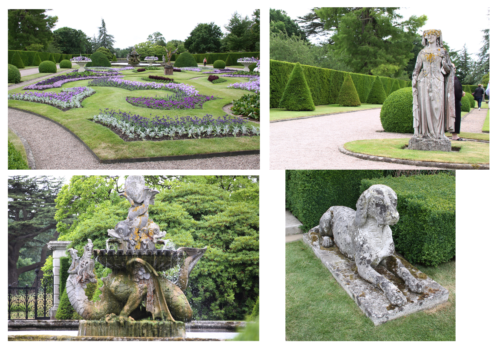
The Dragon Garden is named for the dragon sculpture in the centre of the garden.  A formal geometric garden, planted with small species  of blues, purples, lilacs and mauves, this is a delightful sight, highly structured and precise.  There is a statue of a figure on each corner of the garden, possibly former family members.

After a pause to enjoy the view at the end of the terrace, and to look down over the lioness and kudu sculpture (a truly bizarre thing) we went towards the Dutch Tea House and the accompanying Tea Garden.  Outside this garden, and elsewhere on the estate, several of the vast oaks are wrapped in fine mesh.  I had seen this on a previous visit to the Aldford Iron Bridge on the other side of the estate, and had wondered what it was all about.  A helpful sign explained that it was an experimental measure taken against acute decline disease, thought to be caused by a parasitic boring beetle.  The mesh restricts the movement of the beetles and prevents them spreading.  At the same time, the roots of the tree, under soil compacted over the decades, prevents water and nutrients reaching the tree, so a programme of mulching has been undertaken to help retain water and help the transfer of nutrients and water via the roots into the trees.

The Tea House is a little ornamental building, approached via a path that leads through the pet cemetery, and look out for a delectable little wooden Wendy house on the other side of a low hedge.   If you have a pushchair or wheelchair / buggy, there is a side entrance to the garden that avoids the steps down from the Tea House.  Giant fennel plants give a wonderful bitter-sweet scent on approach to the garden.  The garden has a statue of Mercury at its centre (standing on a personification of the wind).  The garden is beautiful in a less formal way than the rose gardens, with a more unaffected feel, with lovely block-paved paths and beds filled with flowers and highly aromatic herbs that deliver a gloriously chaotic range of different aromatic scents that follow you around.  On a hot day I imagine that it would be even better as the aromas heat through.  

From here there was a choice of walking down to the lake, or taking one of the grass paths to another little temple-like building, referred to as a loggia.  We opted for the walk to the loggia, rectangular this time, which was flanked by two genuine Roman columns and housed a genuine Roman altar, the latter found to the east of Chester between the Tarvin and Huntington roundabouts, about 320 metres east of Boughton Cross, and 1.8 km due east of The Cross, Chester.  Given how much Roman architecture has been lost from Chester, it was probably a kindness to remove and preserve them, although the public only rarely have access.

The altar is today known officially as RIB 460.  On two sides it reads “Nymphis et Fontibus
leg(io) XX V(aleria) V(ictrix),” translated as “To the Nymphs and Fountains the Twentieth Legion Valeria Victrix (set this up).”  It was rediscovered first in 1821.

There is a grass avenue from here back to the Parrot House via the terrace with the lioness and kudu pond.  The band’s little white marquee is stationed in front of the Parrot House so you don’t really get a sense of the connection between the two buildings, but it is a nice arrangement.  As you walk onto the pond terrace, you pass through a grass path flanked with two borders filled with lavender.  We paused to run fingers through it and release the splendid scent.  The wall that runs below the upper terrace where the rose gardens were located is covered in white hydrangea petiolaris, a form of hydrangea that climbs. The pond itself has a vast greened sculpture in the middle showing a lioness about to leap on and kill a kudu (a deer-like animal).  As you walk up behind it, the change of perspective gives a strange sense that the lioness is in motion. It is absolutely not my cup of coco, and I would have it moved somewhere a lot less conspicuous, but it is certainly attention-grabbing.

From the Parrot House it was a short walk along the bottom edge of the walled garden to the field where we were parked.  We found the Air Cadets who were stationed around all the entrances and exits very helpful in sorting out somewhere where I could easily pick up my father.

Later, whilst my father was masterminding a fabulous culinary extravaganza in his kitchen, I read the leaflet about the Cheshire Young Carers charity that the day’s takings were to support.  It was something of an eye-opener to learn how many children care for their parents or their siblings, unsupported by any official mechanisms.  I was so pleased that our tickets had gone towards helping this excellent organization, which not only helps with practical support but organizes away days for children, activities that allow them to escape their responsibilities for a short time.
sdfsfas

Visiting Practicalities

The parking arrangements were very well managed with plenty of Air Cadets and other personnel at the ready to give directions and advice.  The car park was a field.  The field surface was dry buy very uneven.  A brief conversation with one of the parking officials enabled me to drop my father off on the hardstanding that led up to the gardens, and park nearby, where some spaces had been kept free, but if you have a disability badge, there are is special parking right by the entrance to the gardens.

There is a disability stand where disability scooters and other aids can be collected, and the gardens as a whole are generally easy for those with mobility issues, as well as for wheelchair and pushchair users. The gardens are connected with the lake by metalled paths leading between gardens, and within some of the gardens and in the park between them, there are level grass surfaces and light slopes throughout, which (at least on a dry day) are suitable for wheelchairs and pushchairs.  There are not many benches or seats around, and none between the gardens.

It was only moderately busy.  The car parks seemed to be stuffed full of cars, but the park and gardens seemed to swallow visitors very easily.  Only in the places where people tend to convene, like refreshment areas and places where there was live music, was there a sense that it might become crowded.  The gardens themselves gave no sense at all of there being too many people for the space.

Full details of the event, plus booking information, are on the Eventbrite website at:
https://www.eventbrite.co.uk/e/eaton-hall-gardens-charity-open-day-tickets-308591705097

sdfd
Sources:

EventBrite
Eaton Hall Gardens Charity Open Days 2022
https://www.eventbrite.co.uk/e/eaton-hall-gardens-charity-open-day-tickets-308591705097

Historic England
Eaton Hall Park and Garden
https://historicengland.org.uk/listing/the-list/list-entry/1000127?section=official-list-entry

Lost Heritage
Eaton Hall
http://www.lostheritage.org.uk/houses/lh_cheshire_eatonhall_info_gallery.html

Roman Inscriptions of Britain
RIB 460
https://romaninscriptionsofbritain.org/inscriptions/460

The Country Seat
Country houses of the 2014 Rich List – Top 10
https://thecountryseat.org.uk/tag/eaton-hall/

A short walk along the Dee at Holt, taking in Holt Castle

Holt Castle

After a morning of shifting logs, the sad remnants of an enormous fallen tree, from one end of the garden to the other and stacking them in the shed, I was fairly stiff and very bored.  It was a lovely day, so even though there is an immense pile still sitting there, I put the wheelbarrow back in the garage and decided to go and walk along the river, taking in Holt Castle.

A number of people have asked me if I’ve visited the castle yet, and my answer that the last time I saw it was probably 30 years ago always seems a tad lame, given how close it is.  I will talk about the castle on another post, but it was interesting today to see how much it has changed.  When I was last there, it was inaccessible and covered in ivy.  I remember the doorway hanging in the side of the wall, and remembered that it was built on a sandstone base, and that local sandstone was quarried from around the castle to provide building material and form a moat, but I had forgotten anything else that I knew about it.  Today, I was so pleased to see how well it has been served since I last saw it.  There is now a staircase leading to the top of the castle, from which the views of the Dee and the fields beyond are excellent, and there is plenty of signage to explain all the features remaining, and to show what existed in the Middle Ages.  I must try to find the photographs I took 30 years ago for comparison.

I was walking straight into the sun, which was beautiful but blinding, so after visiting the castle I retraced my steps and headed instead towards the bridge, crossed the road just before it, and went through the gate into the grass field that flanks the Dee to its west, heading north in the direction of Chester.  It was only a short walk.  I did not pass out of the field onto the track, which was covered with deep pools of muddy water, but the sun on the grass made it glow, the reflections in the river were lovely, and the cobwebs forming silver nets on the ground were glorious, and all in all it was a really rewarding stroll.


Visiting and accessibility notes

There is no carpark for the castle, but during the week there is plenty of on-road parking.  The footpath leading down to the Dee is well maintained, but as it opens into the open grass it is muddy and a little slippery after rainfall.  That is true for the worn footpaths around the castle too, so suitable footwear is required.  The path leading up to the top of the castle is gravel set into a plastic matrix, and felt very safe underfoot.  The metal staircase up tot he top of the castle is also well-textured underfoot, with a good handrail.  It’s only a short flight.  Do note that the noise from the bypass is considerable, so if you were thinking of carrying on along the Dee to the south after seeing the castle, do bear that in mind.

The walk along the Dee has no car park on the Holt side, but cross the bridge and there is a small car park on the Farndon side, to the south of the river (to the right as you cross from Holt into Farndon).  You can then return across the bridge on the narrow footpath to do the walk on the west of the river heading north.  As you open the gate, you may again find that the converging feet and paws have muddied the approach from the field, making it slippery.  The rest of the walk through the field is slip-free, and on the flat.

A visit to the Pontcysyllte Aqueduct near Llangollen – Thomas Telford’s iron trough 126ft over the Dee

It is without question a marvel of modern engineering and a remarkable sight, but what strikes most people when they first see the 1000ft (c.305m) Pontcysyllte  canal aqueduct is that the handrail along the pedestrian walkway 127ft (38.5m) over the river Dee is only a few steps away from the other side of the narrow canal trough, which has no handrail at all to separate a boat user from a straight drop into the valley bottom.  Until you lean over the towpath’s handrail and look straight down, 127ft is a rather abstract number.  The photograph on the right shows me crossing it on a 40ft narrowboat in the 1990s on a two week canal holiday.  What you cannot see are the white knuckles with which I am gripping the tiller for dear life, in spite of having absolutely no fear of heights, because there was absolutely nothing between me and that drop.  The aqueduct, Grade I listed, and a UNESCO World Heritage Site since 2009, is the longest and highest in Britain.  It’s a long way down.

The Pontcysyllte Aqueduct passing over the Dee valley at Trevor. Source: Dronepics Wales

Seen from below or from a distance, the Pontcysyllte aqueduct is a fabulous sight, not pretty but truly awe-inspiring, and it shows exactly what Pontcysyllte is:  an iron trough built on 18 vast tapering brick piers, with 19 arches.  It was all about function, nothing to do with aesthetics, and has no ornamentation to soften it, but the sheer ambition of it grips the imagination and makes one look beyond the factual details of the thing.  It really is superb.  There is a path leading down along the side of the approach to the aqueduct into the valley below, a long but well maintained track to the valley bottom, where you can walk along the Dee and get a long at the aqueduct from a distance.  That’s one for another day.

It was a beautiful day, absolutely flawless, with cerulean blue skies, a golden sun warming one’s face, and a brightness of autumnal colours that takes some beating.  After attending the Remembrance Day commemoration at the Churton war memorial, with a memorable and moving address, and a two-minute silence filled with birdsong, I collected the car first, the parent next, and we proceeded towards Trevor, on the A539 to Llangollen.  There’s a brown signpost pointing to the aqueduct’s pay-and-display car park at the Trevor Basin, which is the home of a number of canal boat companies today, but when it was built was used for the transhipment of coal, building stone, iron products, timber and bricks, much of which was brought to the canal wharf by horse-drawn waggons.

Map of the key canal features in the Vale of Llangollen. I have added a red arrow to show the best car park for Pontcysyllte. Click to enlarge. Source: Pontcysyllte Aqueduct & Canal World Heritage Site

Thomas Telford and his chosen team

Portrait of Thomas Telford, who chose to be painted with the Pontcysyllte aqueduct in the background. Engraved by W. Raddon from a painting by S. Lane.

The aqueduct (built (1794-1805) was part of the Ellesmere Canal project.  It is one of the many British civil engineering projects that has the names of Thomas Telford (1757-1834), ironmaster William “Merlin” Hazeldine (1763-1840) and master stonemason John Simpson (1755-1815) attached to it, three men who had brought their particular skills to many different joint projects and in doing so had developed an invaluable relationship of trust and mutual respect.

Thomas Telford started his career as a stone mason, working in London on buildings such as Somerset House, and had ambitions to develop his career as an architect.  When he became the County Surveyor for Shropshire, he worked on a great variety of building projects including, by his own estimation, 40 road bridges between 1790 and 1796, two of which employed iron in their construction.   Hazledine had initially trained as a millwright, but  his family owned a small foundry  and Hazeldine went on to grow his iron casting business with the large Coleham Foundry at Shrewsbury.  Hazledine and Telford, both Freemasons, had met at Salopian Lodge  in Shrewsbury in 1789 and become friends and professional collaborators.  On one of his earliest projects in Shrewsbury Telford hired a childhood friend Matthew Davidson to oversee works, and Davidson employed master stonemason John Simpson who worked on many of Telford’s projects. Telford described Simpson as “a treasure of talents and integrity.”

Although Telford is by far the best known of the three, he, Hazledine and Simpson worked together frequently on many different projects to produce some of the great civil engineering constructions of their era, mainly bridges.  All three were involved with the Pontcysyllte aqueduct, where  Matthew Davidson also joined them, but the story of the canal starts before any of them were recruited to work for the Ellesmere Canal project.

Background to the aqueduct

The Trevor Basin today.

The big name in canal construction was James Brindley (1716-1772), who was responsible for building over 365 miles of canals by the time he died.  Brindely realized that any inland waterway network would need to connect to all the great navigable rivers that connected to the sea, including the Thames, the Mersey, the Severn and the Trent, incorporating other important navigable rivers like the the Avon and the Dee.  Most of his canals were contour canals, wherever possible built on the level and avoiding slopes so that locks and lifts could be avoided.  The network was therefore a sprawling affair, but it revolutionized transport, avoiding roads that would become mired and impassable in winter, as well as unnavigable sections of rivers, and the riverine problems of drought and flood.  Water into and out of the canal system was regulated and therefore predictable, and allowed year-round transport.  The advantages became very clear very quickly, and manufacturing and trading businesses began to locate themselves at critical points on the canal network.  Eagerness to invest in infrastructure resulted in a canal boom in the late 1780s and 1790s.  Each new section of canal required an Act of Parliament, subject to Royal Assent, and Act after Act was passed as the network expanded.

The complex arrangement of the Ellesmere Canal and its branches is shown as a think blue winding line. The thick blue line is the Dee. The yellow lines are roads. Click to see a bigger version. Source: Wikipedia

In 1791 a proposal for a canal to link the Mersey at Netherpool (later renamed Ellesmere Canal) to the river Dee at Chester and the Severn at Shrewsbury was discussed by three Shropshire entrepreneurs, carrying mainly coal, iron and lime, supported by other goods as well.  It was decided that a branch would be needed to Wrexham and Ruabon and onwards, via Chirk, bypassing Oswestry at its west, to Shrewsbury in the south with a branch to Whitchurch in the east and another to Llanymynech.  Originally it was planned to run a branch from Ruabon to reach the Irenant slate quarries near Llantysilio, via Llangollen, but this was at first dropped and later revived for different reasons (discussed below).  That branch would in turn connect to the Montgomery Canal from Frankton Junction via Welshpool to Newtown in mid Wales (for carrying limestone, coal, timber, stone and slates).

This seriously ambitious plan found sufficient support for a surveyor to be hired and possible routes to be explored.   William Jessop, an experienced canal engineer, was hired to head up the project and oversee all of its different components.  After disagreements over the final route were resolved (albeit not to everyone’s satisfaction), the Ellesmere Canal proposal went through parliament and received its Royal Assent in April 1793.  There were still a lot of technical and logistical details to resolve, including how the canal was to cross the Dee and Ceiriog valleys.

It was clear that Jessop needed help, and although the internal promotion of William Turner was Jessop’s first choice, Telford was brought in without his input. It is not certain how Telford, increasingly bored with life as a county surveyor, managed to insert himself into this ambitious engineering project, but the canal was already generating considerable excitement in the area and it looks as though he heard of the position and sought the support of one of Britain’s most prominent industrialists, John Wilkinson, to help him secure it.  Jessop made it clear in his letters what he thought of having Telford, who he had never met, brought in against his wishes as his right hand man, and refused to attend the meeting that appointed Telford to the Ellesmere Canal Company.  In spite of this rocky start, Jessop and Telford seem to have hammered out a decent working relationship, with Jessop teaching Telford what he needed to know about canal construction, and Telford injecting some ideas into the project.  Like Jessop, Telford managed to broker a deal to enable him to carry out other projects when his personal presence was not necessary, and this enabled him to work on other civil engineering works whilst the Ellesmere Canal was being built.

Building the aqueduct

Work began at Netherpool on the Mersey, renamed Ellesmere Port, in 1793.  The 9-mile canal ran down the Wirral to meet the Dee at Chester, and went so well that it opened for traffic in 1795 and was an immediate success.  While this section was underway, discussions were underway about how the canal might cross the Dee.  The original idea presented to the directors by Jessop and Turner, and apparently not opposed by Telford, was a relatively low level stone channel crossing three stone arches, with step locks either side to manage the ascent to and descent from the level of the canal to the aqueduct.   This would have been an expensive option, requiring not only the locks but the management of the water that would feed the locks.  Even after this had been agreed in principle, concerns resulted in a new plan for an iron channel on stone columns.  It is likely that it was proposed by Telford and supported by Jessop partly because it would have reduced the cost as iron was lighter, easier to work and move, and cost less.  A sketch by Telford from March 1794 survives showing an early version of this aqueduct design.

Telford’s Grade 1 listed Longdon-on-Tern aqueduct in Shropshire, 1796. Source: Chris Allen, Wikimedia

In early 1795 Telford had the opportunity to try out a smaller, less ambitious version of the design at Longdon-on-Tern on the new Shrewsbury Canal, on which Telford was also working, as replacement for the incumbent engineer who had died mid-project.  Later in the same year he had built a fully navigable iron aqueduct on a canal that had none of the problems of leakage or shattering that had worried other engineers.  Whether or not this was taken into account by the directors of the Ellesmere Canal Company, they decided in the same year to go for the iron trough on immense stone piers that was eventually built.

Telford’s friend and frequent collaborator, master mason John Simpson soon joined him on the project.  Telford also brought in Matthew Davidson, his childhood friend of Telford, a stone mason, civil engineer and excellent organizer, to oversee the bridge works.  Telford and Davidson had worked successfully together on Telford’s Montford Bridge project of 1790 – 1792.  Shortly afterwards, William Hazledine arrived to establish an ironworks and take charge of the construction work for the iron ribs and the trough.  By assembling three men that he had worked with before and trusted absolutely, Telford was not only ensuring that the project was in good hands, but that he had a team who could operate in his absence. The foundation stone for the aqueduct was laid on 25th July 1795.

Jessop and Telford made wooden models to test the design for the trough, finding that 1000s of iron parts would be needed.  The cast iron for the aqueduct was made of cast iron that was produced in William Hazledine’s new iron foundry nearby at Plas Kynaston, Cefn Mawr.  Hazledine established the Plas Kynaston foundry to service the construction of the Pontcysyllte aqueduct, thereafter taking advantage of the canal network to carry his cast iron in segments to be transhipped by river or sea to where it was needed.  When he built the Eaton Hall Iron Bridge at Aldford on the river Dee (described on an earlier post) it was from Plas Kynaston that the iron was shipped by canal.

After 1801 Jessop was much less involved and Telford also had interests elsewhere, and Telford was also involved in other projects, leaving Davidson, Hazledine and Simpson to run with the project.  The piers rose steadily, each built in turn from south to north by, at the peak of the project, over 500 men.  Jessop had been desperately worried from the beginning by the dangers to workmen’s lives of such tall piers, and safety precautions were taken very seriously, with the loss of only one life.  The iron parts were manufactured as needed at Plas Kynaston, and were numbered according to the order in which they would be needed so that only pieces needed at any one time would be delivered to the site.  First, ribs of iron were fitted to the piers, and then the trough was bolted on top, after which a wooden towpath was fitted to the side.  The entire project was finished in 1805, and opened on a sunny afternoon on November 26th 1805 at a grandiose ceremony followed by a lavish feast.  The entire cost for the aqueduct project was £47,018, which in today’s money translates as around £617,855 (National Archives Currency Convertor).

Metalwork over and under the arch at the left-hand Rhos y Coed bridge.

Although not as visible in the finished design, iron was also used in the Chirk aqueduct on the Llangollen canal where ten semi-circular masonry arches were crossed by a water channel with an iron bed plate and brick sides sealed using hydraulic mortar.  As well as in the aqueducts, iron was used in various ancillary structures too.  for example, Bridge 29, Rhos y Coed, at the Trevor Basin has visible iron metalwork supplementing the stone arch, and iron was used to cap the weir at the Horseshoe Falls.

The role of the aqueduct

Map from Nicholson’s Guide to the Central canal system, showing the stump end (framed in orange) of the planned Ruabon to Chester section of the canal, which was never built and now houses the attractive Trevor boatyard where the visitor centre is located. Source: Nicholson 1989

The Pontcysyllte aqueduct was almost immediately  in danger of becoming something of a white elephant, because its original role as a direct route to Wrexham and Chester was never fulfilled.  The section that led past Trevor Basin over the aqueduct was supposed to run straight on to the west of Ruabon, via Wrexham and on to Chester where it would link with the Wirral stretch leading to the Mersey and to the  Dee and the Shropshire Union Canal.  All that is left of the Trevor-Ruabon-Wrexham-Chester branch is a stump end occupied by the Trevor Basin, where the car park is located.  This is clearly visible on Nicholson’s map left, where the main line of the canal comes to a sudden, abrupt end.

The abandonment of this important part of the original plan was due to both engineering problems and financial issues.  There were only  two obvious engineering options – an enormous tunnel or a series of locks climbing towards Wrexham and another descending into the Cheshire plain where the canal could run along the flat plain to Chester.  The tunnel would have been appallingly costly, and it was difficult to know how the locks, by no means a low-cost option themselves, could have been supplied with the sufficient water.  Although other technologies were considered, they were rejected for reasons of practicality and cost.  This left the problem of where the water was to come from to feed the rest of the Ellesmere Canal and its branches.

Horseshoe Falls

At the far end of the Llangollen canal is Telford’s great arc of a weir, today known as the “Horseshoe Falls,” marking the point at which the Dee begins to feed the Llangollen canal.  An original survey had considered using the water of the Dee as it fell from Snowndonia via Lake  Tegid at Bala and through the Vale of Llangollen as a water source for the canal.  The idea had been to link the canal to a slate works, feeding the canal at the same time.  This proposal was now revisited.  The owner of Lake Tegid gave his permission and the plan was actioned.  At the Horseshoe Falls the canal is fed with water from the Dee via a sluice and meter, and today carries over 11 million gallons of Dee water a day, emptying it into Hurleston reservoir, just north of Nantwich, where the Llangollen Canal meets the Shropshire Union Canal.  I will be posting more about the Horseshoe Falls weir on another day.  There is no turning point for vessels over 10ft long beyond Llangollen, so the final stretch is only used by minimal traffic today.

This means that the vast aqueduct, such a remarkable feat of civil engineering, would only ever lead to the relatively unimportant narrow section of canal and feeder to a complete dead end at Llantisilio after passing high through Llangollen.  This navigable channel is approached from the aqueduct by negotiating a sharp left-hand corner just beyond the exit of the trough.  Although this seems like a sad role for an aqueduct that should have carried many times the traffic that it eventually did, without the aqueduct there would have been no water to feed the rest of the system.

Even without the Ruabon – Chester link, those wishing to carry all their goods by canal were still able to connect to the main canal system, although to reach Chester they had to take a very long way round, and Wrexham was excluded completely.  The Llangollen canal still linked to the Shrophsire Union at its eastern end, from which the rest of the vast canal network could be reached.

  • Chester could still be reached by travelling the full length of the Llangollen canal to Hurleston Junction, just north of Nantwich, on the Shropshire Union Canal.  From here Chester was nearly 16 miles away.
  • Just to the north of Hurleston Junction was the Middlewich Branch, which headed east and linked to the Trent and Mersey Canal, from where Manchester, Stoke on Trent, the eastern Midlands and Yorkshire could all be reached.
  • In the opposite direction, from Hurleston Junction the Shropshire Union ran directly to Birmingham, which was a vast junction for canals in all directions, including London on the Thames and Gloucester on the Severn.

The Cefn Mawr railway viaduct, which opened in 1848.

Along the line that the original canal would have taken, a cast iron tramway was built to connect local collieries and ironworks with the canal, the iron supplied by Hazledine.  This made the Trevor Basin a particularly important hub of activity, taken delivery of bricks, tiles, coal, iron limestone, slate and sandstone for transhipping along the canal.  It was also a boatyard, with  working narrowboats being built and repaired by Hills Boatyard in the dry dock next to the Visitor Centre (now occupied by a floating take-away café).  Later, there was an interchange with the steam railway.

Visiting Pontcysyllte

A small pay-and-display car park is available for visitors at the Trevor Basin, now the home of some canal trip and holiday companies.  There is also a pub with outdoor seating, and a take-away small café on a little boat next to the visitor centre.  There is a lot of disabled parking provided for in the small car park, which is reached from the A539 in Trevor, clearly signposted with brown heritage signposting.   The aqueduct is a very short walk from the car park, and the towpath heads for miles in both directions.

If, before or after crossing the aqueduct, you are interested in finding out more about the general context of the aqueduct and its location in relation to other parts of the canal, at the Trevor Basin there is a visitor centre, a small but nicely put together display space.  As well as a map of the area that takes up a wall and shows all the main features of the landscape and the canal system itself, there is a display of some of the tools that were used in the construction of the aqueduct, which are startlingly basic, and photographs and artists’ impressions of some of the supporting works, including the foundry at Plas Kynaston.  There are ring folders full of additional information, including facts and figures, that you can look through.

Walking the aqueduct itself is not for everyone.  The towpath is rock solid, with a tall handrail on the valley side, but only wide enough for two people, so there is a lot of stopping still to allow others to pass and there is nothing to stop you falling into the canal.  The canal is only just over 6ft (1.8m) wide, and beyond that is an unrestricted (no handrail, no nothing) drop 127ft to the valley floor.  A couple who I passed told me that they were determined to walk the full length and back, but were conquering their fears to do so, and they were gripping firmly to the handrail.

An alternative to walking is to cross by boat.  There are a number of short cruises that leave the Trevor Basin and run for about 20 minutes before turning and coming back (depending on which one you take and the time of year).

For those with uncooperative legs, everything is on the flat, so it is a very good walk for those who find uphill sections of walks difficult.  After rainfall, towpaths always become a bit muddy, and can be slippery, but even though we’ve had some rainfall recently, it was fine.  The towpath between Trevor and Llangollen is beautiful, and a good choice if you can face the aqueduct.

I noticed that one of the passenger boats said that it was suitable for disabled passengers, but I would recommend getting in touch with them first to find out about timings, prices and suitability for different types of disability.

Sources

Books and papers

Glover, J.  2017.  Man Of Iron.  Thomas Telford and the Building of Britain. Bloomsbury

Lynn, P. A. 2019.  World Heritage Canal.  Thomas Telford and the Pontcysyllte Aqueduct.  Whittles Publishing.

Nicholson, R. 1989 (4th edition). Nicholson/Ordnance Survey Guide to the Waterways 2: Central. Robert Nicholson Publications and Ordnance Survey

Rolt, L.T.C. 1958, 2007.  Thomas Telford. The History Press.

Pattison, A.  n.d. William Hazledine (1763-1840): A Pioneering Shropshire Ironmaster.  West Midlands History https://historywm.com/articles/william-hazeldine-1763-1840  (Pattison’s full 278-page M.Phil, on which the article is based, is available here: https://etheses.bham.ac.uk/id/eprint/3358/1/Pattison12MPhil.pdf )

Websites

Canal and River Trust
Montgomery Canal
https://canalrivertrust.org.uk/enjoy-the-waterways/canal-and-river-network/montgomery-canal?gclid=CjwKCAiAp8iMBhAqEiwAJb94z7aIVzLoaYuqtwbDdRQsaUL73ssnmF_u1LpoURZmI9YxVUlrKi15whoCtxoQAvD_BwE

DronePics Wales
Pontcysyllte
https://dronepics.wales/pontcysyllte/

Engineering Timelines
Longdon-on-Tern aqueduct
http://www.engineering-timelines.com/scripts/engineeringItem.asp?id=308

Grace’s Guide to British Industrial History
James Brindley
https://www.gracesguide.co.uk/James_Brindley
William Hazledine
https://www.gracesguide.co.uk/William_Crosley_(1802-1838)
William Jessop
https://www.gracesguide.co.uk/William_Jessop

Pontcysyllte Aqueduct and Canal World Heritage Site
https://www.pontcysyllte-aqueduct.co.uk/


Ranulf III’s Beeston Castle #1 – Who was Ranulf?

The approach to the inner ward (or bailey) seen from the bridge, with the vast ditch below, part quarry and part defensive device, and a slice of the superb panoramic view in the background.

The English Heritage Guidebook to Beeston Castle opens with the following statement:  “Standing on a rocky crag high above the Cheshire plain, Beeston is one of the most dramatically sited medieval castles in England.”  Organizations keen to puff off the virtues of their sites are often guilty of hyperbole, but in this case, the guide book speaks nothing but the truth.  On a bright mid-August day, with the sky a silvery pale blue, it was absolutely spectacular, both on the approach to the solidly impressive fortifications from below, and standing in the inner ward above the plain, gazing east to the Welsh foothills and northwest to the Pennines, with the floor of the world reaching out in all directions, lovely and fabulously impressive.  All this and history too.

This post has been split into two parts, with Part 1 looking at Ranulf III himself, and Part II tackling the castle itself, looking at how it was built, used and perceived, covering 600 years from the 13th to 19th Centuries.

If you would prefer to download parts 1 and 2 as single a PDF, please click here.

Ranulf III

Although Beeston Castle was altered several times since its original construction, it was the brainchild of Ranulf III (Ranulf de Blondeville), the 6th Earl of Chester and first Earl of Lincoln (1170-1232).  Ranulf’s castle building phase came fairly late in his very busy and dangerous life as the most powerful magnate in England.   The first work on Beeston Castle took place c.1220, only 12 years before his death, so this needs to be understood in the context of the rest of his life. 

Hugh de Kevelioc’s coat of arms, featuring five wheatsheaves.  Source:  Wikipedia

Ranulf was a descendent of the powerful Norman Marcher Lords installed by William the Conqueror to provide a buffer against the perceived chaos across the border in Wales.  Wales was at that time a set of territories controlled of powerful families headed by chieftains who were often in armed dispute with one another as well as with England  The Marcher lords, acting as guardians of the border, were incentivized with land, title and, perhaps most importantly, a great deal of autonomy.  Originally intending to shift the border further into Wales, the Marcher lords found the mountainous territory of the Welsh chieftains a serious impediment to progress and instead consolidated their positions in the lowlands.  However, the give and take of land and lives continued throughout Ranulf’s life, in spite of both reprisals and peace treaties.  It was not until after his death, during the reign of Edward I, that attacks by the Welsh chieftains were eventually squashed.  The loss of Crown lands in France by previous kings meant that Edward had had plenty of time to devote to the problem.

Ranulf’s official seal, reading “Seal of Ranulf Count of Chester and Lincoln.” The wheatsheaf emblems were later adopted by the Grosvenor family and can be seen on the outside of Churton-by-Aldford’s former school.  Source:  Wikipedia’s Ranulf III page

Ranulf, being of Norman stock, probably thought of himself primarily as Norman rather than English.  His mother was Bertrada de Montford, a cousin of Henry II from Evreux in eastern Normandy.  His father was the 5th Earl of Chester, Hugh de Kevelioc.  Hugh de Kevelioc was born in 1147, the son of Ranulf II, 4th Earl of Chester and Maud, the daughter of Robert the 1st Earl of Gloucester, who was an illegitimate son of King Henry I.  When his father died in 1181, Ranulf became a royal ward of Henry II and was sent to Henry’s court in Normandy, accompanied by his mother and four sisters.  When he came of age, knighted as Earl of Chester, he had inherited Chester Castle and the important trading port of Chester, together with valuable territories in Normandy until these were lost in 1204-5 by King John.  Sadly, there are no images of him.

Chester had been established as a palatine by William the Conqueror, granted special powers, removing it from of the direct control of the Crown, but Ranulf’s other estates could be redistributed at the whim of the king, to reward or punish, or merely reorganize.  Although Ranulf’s holdings expanded and contracted throughout his adult life he remained one of the most powerful men in England.  

Henry II

Henry II and his children.  From left to right – left to right: William, Henry, Richard, Matilda, Geoffrey, Eleanor, Joan and John.  Source:  Wikipedia

Ranulf, brought up in the court of Henry II, was loyal to the kings Henry II, Henry’s sons Richard I and (eventually) John, followed by John’s son Henry III.   These rulers were collectively known as the Angevin kings.  The period leading up to Henry II’s death was one of conflict, with his sons, Richard, Geoffrey and John turning on him due to the uncertainties of succession. 

At Henry II’s request Ranulf  married Constance of Brittany in 1189 at the age of 19, giving him the right to call himself Duke of Brittany.  Constance was widow of Geoffrey of Brittany, and mother of Arthur of Brittany who was next in line to the Duchy of Brittany.  Henry wanted to diffuse a situation in which Brittany was supporting his son Richard against him.  1189 was also the year in which Ranulf was knighted Earl of Chester by Henry.  Ranulf was now in control of his estates in England and Normandy.   Unfortunately, Ranulf and Constance soon developed a mutual loathing that lead to their separation within five years.  1189 was also the year in which Henry died and Richard I “the Lionheart” came to the throne, without further hostilities being required to assure the succession. 

Richard I

Richard I painted c.1250–55 by Matthew Paris in his Historia Anglorum. Source: Dorling Kindersley findout

Under Richard the Lionheart, the newly knighted Ranulf, connected to Richard via their relationship to Henry I, was given a role of key importance role in the coronation procession, carrying the jewel-encrusted crown.  Richard departed on crusade just a year later, having appointed a number of officers to oversee  his interests in England during his absence.   He also named his heir in case he perished during the crusade.  Instead of his younger brother John, he named Ranulf’s stepson, heir to Brittany, Constance’s son Arthur.  Unsurprisingly, Prince John’s nose was now firmly out of joint and he attempted to take the crown, supported by the king of France, Philip Augustus.  He was opposed by a number of powerful barons, including Ranulf.  Learning, weeks after the fact, of trouble at home, Richard decided to return, but he was humiliatingly delayed when he was recognized on the return leg of the journey, captured and held hostage in Germany.  Following an eye-watering payment Richard was freed, and his return settled the matter of John’s ambitions.  Richard underwent a second coronation just to push home the point.  Ranulf remained loyal to the king and followed Richard into war in Normandy and Brittany, where his estranged wife Constance was now stirring up rebellion.  In a rather botched attempt to split Arthur from Ranulf’s estranged wife Constance, both were ambushed in a trap set up by Richard with Ranulf’s help.  Constance was taken prisoner by Ranulf, who was now able to refer to himself one again as Duke of Brittany, but Arthur fled to the comparative safety of the King of France, Philip Augustus.

Whilst Ranulf was fixed in Normandy, Llewelyn the Great attacked and took Mold (then known as Montalt).  Mold was retaken but Ranulf’s trusted supporter, Ralph de Montalt, died in the conflict.  Ranulf was powerless to do anything about this, but it was just one more indication that something needed to be done about Wales.

Richard died in 1199 in a minor dispute (allegedly over rights to a Roman treasure), and with Arthur now allied with France, John succeeded to the throne. 
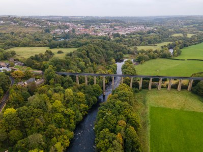
John

King John painted c.1250–55 by Matthew Paris in his Historia Anglorum. Source: TLS

Ranulf, having opposed John’s attempted coup, needed to prove his loyalty in the face of John’s notorious paranoia.  Ranulf was now about 29 years old.  He spent a lot of time early in the reign shifting between his territories in Normandy and England, while John reconciled himself with Arthur by naming him Duke of Brittany (ending Ranulf’s tenure) and Earl of Richmond.  The reconciliation was short-lived.  Arthur attacked Angers, taking a key Angevin castle, a terrible shock to John, who took instant revenge by taking the castle at neighbouring Le Mans, where Arthur’s mother Constance was staying.  He razed both castle and village to the ground. 

Arthur fled back to Philip Augustus.  Ranulf, joining John, swore loyalty to him at a big gathering in eastern Normandy in 1199, but John remained suspicious of him and it took time to win his trust.  This was not helped when, in 1200, Ranulf married Clemence de Fougeres, whose family had connections to both Brittany (via her father) and Normandy (via her mother).  John had a personal interest in Clemence himself, and was also concerned that Ranulf’s loyalties might be divided.  Ranulf doggedly pursuing his policy of demonstrating loyalty to John, stayed at court and accompanied the king on his travels throughout his territories. 

Arthur paying homage to Philip Augustus of France. Chroniques de St Denis, British Library.  Source:  Wikipedia

Constance, mother of Arthur, died in 1201 from leprosy.  Arthur, attacking another Brittany castle, was captured and imprisoned.  In 1202 he disappeared, probably having been murdered.  In response, Brittany rose up in revolt backed by Philip Augustus, king of France, who began to move against Normandy.  After an initial serious hiccough, when John charged Ranulf with treason, Ranulf was reinstated and his briefly confiscated estates returned to him.  He set about proving his loyalty during the campaigns in Brittany and French-occupied Normandy.

Staggered by the speed at which Philip Augustus was moving, and anticipating defeat, John left for England in December 1203, leaving his followers to defend his territories as best they might.  Ranulf followed shortly afterwards, similarly leaving his castles to defend themselves.   Although the war in France had continued in both John’s and Ranulf’s absences, Normandy was lost by 1205.  Ranulf, at court in England with John since late 2003, managed to weather the storms of John’s suspicions and continued to travel with the court, accompanied John in military expeditions to Poitou and Gascony and supported John in the face of the First Baron’s War.  Ranulf had, however, lost his five great castles in Normandy, together with the small private army that supported them. 

After another hiccough, when Ranulf’s loyalty was once again questioned in early 1205 by John, Ranulf again successfully challenged the accusations levelled at him.  Given John’s suspicions, it seems bizarre that only a year later John was so impressed by Ranulf’s loyalty that he rewarded him with so many titles and “honours” (estates) that he became the most powerful and wealthy man in England.  By 1208 Ranulf was not only Earl of Chester but also Earl of Lincoln, Earl of Richmond and had rights over Lancaster and Leicester.  The land and income associated with these honours were vast. 

Henry III

The coronation of Henry III. Source: Wikipedia

Following John’s death in 1216, the 46 year old Ranulf paid homage to the new king, the 9 year-old Henry III, and went to war in his name against Louis of France.  The king’s first Justiciar (effectively an acting regent) was Earl Marshall, a friend of Ranulf’s, and the transition seemed to go smoothly for Ranulf.  Fulfilling a promise to King John, Ranulf took an important part in the siege of Damietta in Egypt in 1218 during the 5th Crusade, returning after two years of battle.  He left Egypt in July 1220, arriving in England a month later.

Ranulf returned, having lost many friends to the crusade, to find that his friend Earl Marshall had been replaced as Justiciar by Hugh de Burgh, a long-standing enemy.  With two years of accumulated business to take care of, including repairs to some of his properties, he was kept busy with his own estates, but Henry also awarded him with new estates.  Disruptions over the rights to a number of castles involved Ranulf in military activity on behalf of the Crown in Northamptonshire, and then again on both his own and the Crown’s account at the Welsh borders, the latter at least partly resolved in the case of the Chester border with the marriage of Ranulf’s nephew John le Scot to Llewellyn’s daughter Helen in October 1223. 

Section of the outer ward’s curtain wall with remains of one of the D-shaped towers

Ranulf soon embarked on a major programme of castle-building, rebuilding castles at Bolinbroke Castle in Lincoln, Chartley in Staffordshire and  establishing a new castle Beeston in Cheshire.  Of the three, Beeston was by far the largest.  Ranulf’s reasons for wanting these castles, particularly Beeston Castle, which competed in scale and ambition with those of the kings themselves, have been much debated.  It has often been assumed that Beeston Castle, which was started in around 1220, was erected as a deterrent to the Welsh princes, but this was apparently not the case.  Not only is Beeston too far east of the Welsh border for this to be practical, but before building his castle, Ranulf had made his peace with Llewellyn the Great, whose territories met Ranulf’s along the Welsh border.  He felt sufficiently safe after the signing of this treaty to leave on the 5th Crusade in 1218 without any risk to his territory from Wales.  Although there had been a brief disruption after Ranulf’s return, this was at least partially resolved by the marriage of his nephew John le Scot to Llewellyn’s daughter, sealing peace if not actual friendship between Llewellyn and Ranulf.   Nor does Wales explain his other two castle-building enterprises.

The approach to the gateway to the inner ward with remains of the curtain walls and D-shaped towers

Perhaps surprisingly, the English crown represented a far greater risk to Ranulf’s security than Wales.  Henry III did not assume control of his government and territories until 1227, seven years after Ranulf started the building works at Beeston.  During this period control remained with Henry III’s Justiciar, Hubert de Burgh,  Ranulf’s enemy.  Disapproving of the way in which so much Crown territory had been given away as favours under previous reigns, Hubert de Burgh had started to claw back land and assets wherever he saw weakness.  It was now that Ranulf started to make improvements to his existing properties and to build his three new castles: Beeston Castle in Cheshire,  Bolinbroke Castle in Lincoln and Chartley in Staffordshire.  The new castles were probably intended to be Ranulf’s insurance against a royal land-grab happening to him, mainly acting as a statement of political authority and independence.

The great ditch around the inner ward, used for quarrying building fabric for the castle, as well as defence.

By raising taxes, Ranulf could easily afford these great projects.  Iain Soden describes Ranulf’s properties at this time:

Ranulf continued to hold the largest number of lands of any magnate in England; with them came the bulk of the armed forces.  Besides his ancestral earldom of Chester, the Honour of Chester stretched right across the Midlands, out into Gloucestershire and across Staffordshire and Warwickshire into Northamptonshire.  Outlying lands attached to the honour lay as far south as Devon and as far north as Derbyshire.  His earldom of Lincoln was intact, stretching from Yorkshire to Leicestershire, white the honour of Leicester linked his norther n lands with those in Northamptonshire.  To these, of course, could be added the family lands.  His brother-in-law Ferrers held the earldom of Derby and now the honour of Lancaster while his nephew was Earl of Huntingdon.

As his castles were being built, Ranulf continued to be in attendance at court and again returned to battle in France in 1230, this time against Louis IX, remaining until 1231, with a successful outcome.  He returned to England later that year.

Ranulf died on 26th October 1232 at the royal castle in Wallingford, 12 years after he began work on Beeston Castle.  Consistent with the traditions of the time, when he died his body was eviscerated (internal organs removed) so that it could buried in three locations.  His entrails were buried at Holy Trinity Priory at Wallingford.  His heart was buried at Dieulacrès Abbey, the Cisterian monastery that he had relocated, in 1214, from Poulton, south of Chester and just north of Rossett, to Leek in the Midlands.  His  embalmed body was then returned to Chester and buried in the chapter house of the Benedictine Abbey, St Werburgh’s, next to his father and grandfather. He had no children.

Ranulf was a really fascinating historical figure, a powerful magnate, and a key figure in the lives of the Angevine kings.  Although he was swept up in the royal imperative to hang on to existing territories, retrieve lost ones, and acquire new ones, as well as meet the crusading demands of the Pope, he stands out as someone who was immensely powerful in his own right, loyal to the Angevine kings but perfectly confident to engage in strategic planning on his own behalf.  In spite of the skilled work of his biographers, who have delved into difficult contemporary documents, Ranulf as a personality remains elusive, lost in the accounts of military and courtly engagements, actions and deeds.  He respected, cared for and supported his friends, detested his first wife, apparently rubbed along well with his second one, and engaged in bitter conflict with one of Henry III’s key advisors.  He had a passion for hunting, a quick temper, was an excellent project manager, a compelling leader of men and was unafraid of exposing himself to the genuine horrors of war, often engaging in fearsome hand-to-hand combat.  There is the suspicion that his final phase of castle building had as much to do with vanity as a fear of having his estates confiscated, but that remains pure speculation. There is no surviving image of him to give an impression of what he looked like.

For anyone wanting to read more about Ranulf III, whose extraordinary and complicated life cannot be more than touched upon in a post of this length, Iain Soden’s “The First English Hero” is a good read, details of which are in Sources, at the end of this post.

Part 2 looks at the castle itself, both how it was used and how it was perceived, from the 13th to 19th Centuries.

Sources

Books and papers

Alexander, J. 1982. RANULF III OF CHESTER: An Outlaw of Legend?  Neuphilologische Mitteilungen, 83(2), p.152-157.
http://www.jstor.org/stable/43343443 (available free with registration)

Gillingham, J. and Griffiths, R.A. 1984. Medieval Britain.  A Very short Introduction.  Oxford University Press

Liddiard, R. and Swallow, R.E. 2007. Beeston Castle. English Heritage Guidebooks

Rubin, M. 2014.  The Middle Ages.  A Very Short Introduction.  Oxford University Press

Soden, I. 2021 (second edition). The First English Hero: The Life of Ranulf de Blondeville. Amberley

Ward, S. 2013 (second edition). Chester. A History.  The History Press

Websites

English Heritage
Description of Beeston Castle
https://www.english-heritage.org.uk/visit/places/beeston-castle-and-woodland-park/history/description/
Research
https://www.english-heritage.org.uk/visit/places/beeston-castle-and-woodland-park/history/research/
History
https://www.english-heritage.org.uk/visit/places/beeston-castle-and-woodland-park/history/
Sources for Beeston Castle
https://www.english-heritage.org.uk/visit/places/beeston-castle-and-woodland-park/history/sources/

Oxford Dictionary of National Biography (locked)
Ranulf (III) [Ranulf de Blundeville], sixth earl of Chester and first earl of Lincoln (1170–1232) by Richard Eales
https://www.oxforddnb.com/view/10.1093/ref:odnb/9780198614128.001.0001/odnb-9780198614128-e-2716;jsessionid=A550860211C96B6006DE6E8E327F88A1

Hidden Holt: An illuminating must-visit exhibition currently at Wrexham Museum

Cover of the free English/Welsh booklet accompanying the exhibition published by Wrexham Heritage Service, 2021.

My thanks to Brian Payne of the Holt Local History Society for alerting me to the fact that the Hidden Holt exhibition has been launched at the Wrexham County Borough Museum, running until 29th January 2022.  I went last week my father, and we were both bowled over by how good it was.

The exhibition introduces the Roman tile, brick and pottery works that were spread across a number of fields to the northwest of Holt, next to the river Dee.  It uses an excellent combination of original artefacts, video,  information boards and both old and new photographs and diagrams to track the twin stories of the site itself and the history of its discovery and excavation.  Holt Local History Society has a long-standing interest in the Roman works, and commissioned the most recent geophysical survey work at the site, so it’s great to see their contribution to the story being celebrated.

The exhibition (free to enter) is in Gallery 3, to the left as you move beyond reception and the café to enter the display areas.  I’ve given an overview below, but I seriously recommend that you just go – it is a tremendous, professionally-produced and beautifully designed little exhibition with some superb objects on display and some excellent information boards that explain what you are looking at.  You won’t regret it.  If you’re in the mood, the café serves a great coffee and what looks like a rather delicious lunch 🙂

Survey and excavation

Arthur Acton –  page 5 of the booklet accompanying the exhibition.  Source: Wrexham Heritage Service, 2021

The story of how the site was recognized and investigated begins in the early 1600s when landowner Thomas Crue of Holt Hill suffered repeated damage to his plough on broken brickwork and eventually discovered a series of fifty 2ft-tall posts and recorded this in a letter now in the British Museum.  The letter was mentioned in the book Roman Cheshire by W. Thompson Watkins (1886).  Retired chemist and keen amateur historian Alfred Neobard Palmer read the book, and in 1905 decided to hunt for the remains that Crue had found.  He tracked down the original letter and accompanied by local vicar Jenkyn Jones, and with the permission of the landowner Mr Beard, he engaged in a series of fieldwalking expeditions that found plenty of fragments of Roman bricks, roof tiles and pottery over an area of some 20 acres.

Fold-out plan of the kilns at Holt, published by Grimes in 1930. (Scanned from my copy of “Holt, Denbighshire”)

Palmer was not an archaeologist, and the task of excavating the site was taken on by Wrexham solicitor and amateur archaeologist Arthur Acton.  Work began in 1907,  in Wall Lock Field, and continued until 1915.  Although he lectured prolifically about the site, Acton never published his work.  Fortunately some of his records survived, and he sold the finds to the National Museum of Wales.  After five years of admirable work, the Assistant Keeper of Archaeology at the National Museum, William F. Grimes who was better known as a prehistorian, published a comprehensive 235-page report on the site, complete with site plans, photographs and object illustrations.

Photograph and logo from the Archaeological Survey West website: http://www.archaeologicalsurveywest.co.uk/

Work did not stop there, and during the 1970s Geoffrey Bevan conducted both field walking activities and an excavation, finding Roman material that filled dozens of boxes, which were donated to the Grosvenor Museum in Chester.  Most recently, Holt Local History Society commissioned Archaeological Survey West to carry out a geophysical survey of the site,  to accurately fix the positions of the known buildings and to identify any unexcavated and previously unknown structures.  This was successfully completed in 2018, and demonstrated that the Holt complex was even bigger and more complex than Grimes, via Acton, had been able to determine.  There is, of course, the potential for future field research.

The exhibition

Piece of a colander manufactured at Holt, on display at the exhibition

The exhibition is based mainly around discoveries made during the Acton excavations, using the Grimes and later reports to explain what was found and what has been discovered since.  Between them, Crue, Palmer, Acton, Grimes, Bevan, Holt Local History Society and Archaeological Survey West have produced a history of what lies beneath those lush green fields, and this is what the exhibition introduces.
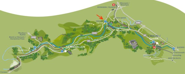
As usual usual the exhibition’s narrative is arranged in a clockwise direction, so turn left as you walk in to Gallery 3.  The exhibition begins with a video that explains the history of survey and excavation and then talks about the site itself.  It is well worth taking a seat and watching.  It lasts about 15-20 minutes and is chock-full of information with some terrific photographs, diagrams and artist impressions of what various structures may have looked like.   The technique of superimposing building plans over a modern aerial view of the fields is particularly useful for understanding how the site was composed and what each element consisted of.   From there, the excellently designed displays take the visitor through the site’s history.

Site plan of the Roman tile and pottery work displayed in the exhibition. Also in the excellent booklet accompanying the exhibition, full details in Sources below. Click to see a bigger version with fully legible text.  Source: Wrexham Heritage Service, 2021

The site was more elaborate than I realized, composed of a number of buildings as well as the kilns.  The image on the right is shown at full size in the exhibition, and shows how big a complex the Holt tile, brick and pottery works actually was.  This is a bang-up-to-date site plan, combining the information provided by Grimes in 1930 with the details obtained by Archaeological Survey West in 2018. What this and a lot of Acton’s photographs makes clear, is that the site was a fully integrated operation combining industrial, public and domestic architectural components. A senior manager had his own house, complete with hypocaust (under-floor) central heating, there was a public bath house, presumably for workers, a series of kilns for the manufacture of mainly tiles and pottery, and a barracks that may have housed workers, or alternatively a detachment of the Roman army based at Chester at this time.  The features shown in blue are unrecorded / unexcavated.  Those in dark brown are the building locations fixed in 2018, and those in paler brown those estimated by Grimes based on Acton’s work.

The main kiln plant at Holt, published by William Grimes in 1930. Scanned from my copy.

Although now the archaeological remains are covered with fields, Acton used photography extensively, and his site plans were detailed, many published by Grimes, and used in the exhibition to reveal and explain the different components of the site.  This is very helpful not only for understanding how the site worked as an end to end operation, but is invaluable for putting the objects into context.  Objects on their own tell a limited story, but when contextualized in terms of the buildings in which they were produced and used, come to life.  The exhibition does this brilliantly.

It was a good location for a tileworks.  Building stone was available in the immediate locality thanks to the Bunter sandstone, alluvial clay was available locally, woodlands were present for the provision of fuel to feed the kilns, and the river Dee provided direct access to Chester, 12 miles / 19km away, passing the civic settlement at Heronbridge.  The generally flat environment meant that building of roads was not particularly laborious.

The visitor is taken step-by-step through the production process, explaining how the kilns and drying sheds  were built and how they functioned. The kilns formed two main units, a larger (139ft / 52m long, consisting of a row of six kilns) and smaller twin-kiln built on the natural bed-rock.  Each kiln was rectangular and tile-lined with an arched stoke-hole for access.  A round pottery kiln was also located on the edge of the main kiln complex.  The oven floor was fascinating, consisting of a raised floor of tiles plastered with clay that were pierced with holes that acted as vents.  I was fascinated to see that the drying shed was provided with a hypocaust, better known as the under-floor heating system that was used in villas and bath houses.  These, like the kilns, were stoked and kept hot to ensure that the tiles, pottery and bricks were dried through after firing.

The exhibition displays a number of artefacts, including a roof tile, a brick and a triangular atefix tile marked with the letters LEGXXVV, an abbreviation for the twentieth legion, known as Valeria Victrix (valiant and victorious).  The antefix tile, one of which is shown in the exhibition (photo left and illustration below) also shows Legio XX’s dramatic running boar symbol.   Legio XX was stationed at Chester from AD87, and the Holt works appears to have been established shortly afterwards, reaching its peak output at around AD135, and falling out of use in the mid 3rd Century.

Antefix tiles from Holt. Source: Grimes 1930

A display board shows the vast range of products that were made at the site, including floor and roof tiles, and a variety of different pottery forms.  There is a good explanation of how the roof tiles, called imbrex and tegula (plural imbrices and tegulae), worked.  A good memory for me – I dug up a lot of these tiles at my first ever dig in Silchester.  The arched imbrices, sit snugly over the upright edges of two facing tegula tiles, as shown in the above photograph, and the the triangular antefix tiles were placed to cover the ends of the imbrex.

Green-glazed ware found at Holt. Source: National Museum of Wales

Examples of the pottery found at the site are on display, with some really fine examples, including ollae (jars), urcei (jugs), lagenae (flagons), cattili (plates), calices (drinking bowls), and testa (lids).  I particularly liked a partly preserved ceramic colander and a mortarium (the latter working like a modern mortar, but with bits of stone embedded into the interior base of the pot to create a rough surface for grinding spices and seeds).  Green-glazed pottery, a luxury ware that I had never come across before, was also made at the site.  It is rare in Britain, so it was excellent to see examples of it on show.  A photograph of the green glazed pottery found at Holt (from the National Museum of Wales website) is shown below.

The workers also turned their hands to other types of objects made from clay – one cabinet shows a marvellous piece of shaped water pipe that was manufactured at the site.

Section of water pipe manufactured at Holt

All of the output manufactured at the works was sent by boat downriver to Chester, the exhibition suggests that a short may have been dug out at Holt in order to make loading the ceramics easier, its course marked today by annual floodwaters that, as they recede, leave a line of floodwater in what could well be a Roman channel.

Samian pottery found at Holt. Source: Grimes 1930

Interestingly, the exhibition shows that even though huge amounts of pottery was being made on-site, there were particularly favoured types of ceramic being imported.  Samian (terra sigillata), a truly gorgeous luxury dark red ware that has moulded decoration on its lustrous surfaces, was found in surprising quantities.  This was usually imported from south-eastern Gaul (France); a Roman experiment with samian production in southern England produced inferior pottery and was very short-lived.

Imported black-burnished ware was also found at Holt, which the exhibition explains was made in Dorset.  At sites in southern England it is common (we found bucket-loads of it at Silchester), but when found at northern sites, it was probably imported to fulfil a particular need or desire.  The works manager might have wanted high-status ceramics, and any soldiers at the site may have craved the comforts of home, but another option is that it was being imported for use by a nearby settlement.  One of the findings of the 2018 geophysical survey was the presence of a possible Roman fort or marching camp to the west of the site, suggesting that the site may have been on the edge of an unidentified vicus settlement, or village.

Coins on display in the exhibition.

The coins at the site are invaluable for their contribution to creating a timeline for development of the site, but are works of art in their own right.

The exhibition provides another insight into the inhabitants of the site by displaying some of the other objects they owned, like small pieces of jewellery made of bronze, manicure equipment, a beautifully crafted needle and a delectably delicate silver spoon.  These are objects that people chose and kept on them, intimate reminders that these were real people who lived complicated lives in which personal appearance had an important role.

Silver spoon from Holt on display at the exhibition. Source: Grimes 1930

A map at the end of the exhibition was riveting, showing how widespread Roman presence in northeast Wales actually was, showing everything from single find-sites to industrial sites like that at Holt, the settlements at Heronbridge and Plas Coch, and the villa at Rossett, the latter two sites both recent discoveries.  It looks as though there will be more Roman discoveries in the future, filling out a picture not merely about the activities of Romans in Britain, but on their interactions with local communities, something which remains poorly understood.

Museum details

The museum is an excellent resource, a small but modern with excellent displays and a lot of great information on professionally produced display boards into context. At the time of writing (August 2021) masks must be worn and you need to leave your name and telephone number with reception.  For opening days and times, plus directions, see the Wrexham County Borough website:
http://old.wrexham.gov.uk/english/heritage/wrexham_museum.htm

A booklet accompanying the exhibition is available both in the museum foyer and under the video screen in Gallery 3.  The cover and some of the pages from the booklet are shown at the top of the post, and full details are in Sources, below.   A leaflet, Holt: Legacy of the Legions, is also available from the museum, or can be downloaded.

It is a real shame that the Hidden Holt gallery is only a temporary feature, but Wrexham Museum has a lot more to see, and I will be posting about some its permanent displays in the future.

Sources:

Books and papers

Grimes, W.F. 1930.  Holt, Denbighshire:  Twentieth Legion at Castle Lyons.  Y Cymmrodor.  Society of Cymmrodorion.

Ward, M. 1998. A collection of samian from the legionary works-depot at Holt.  In (ed.) Bird, J. Form and Fabric.  Oxbow Monographs 80.
https://www.researchgate.net/publication/333155555_A_collection_of_samian_from_the_legionary_works-depot_at_Holt

Ward, M. 1998. Some finds from the Roman works-depot at Holt.  Studia Celtica 32:43-65
https://www.researchgate.net/publication/311789557_Some_finds_from_the_Roman_works-depot_at_Holt

Booklets / leaflets

Wrexham Heritage Service 2021.  Hidden Holt.  The Story of a Roman Site.  The Discovery of a Roman Legionary Tile and Pottery Works at Holt, near Wrexham.  (Booklet accompanying the exhibition in both English and Welsh)

Holt Castle Conservation and Interpretation Project.  Holt. Legacy of the Legions.  An introduction to the history of the Legionary Works Depot at Holt. (Leaflet, including site plan, available from the museum)
http://old.wrexham.gov.uk/assets/pdfs/heritage/holt_castle/holt_legacy.pdf

Websites

Hidden Holt
Wrexham Museum
https://www.wrexhamheritage.wales/?exhibition=hidden-holt-the-story-of-a-roman-site

Hidden Holt – Roman history revealed in a new Wrexham Museum exhibition
Wrexham Council News
https://news.wrexham.gov.uk/hidden-holt-roman-history-revealed-in-new-wrexham-museum-exhibition/

Holt Local History Society
https://holtlhs.weebly.com/

National Museum of Wales
https://museum.wales/

Roman Glazed Pottery from North Wales
National Museum of Wales
https://museum.wales/articles/1327/Roman-glazed-pottery-from-North-Wales/

The Pottery Kilns of Roman Britian by Vivien Swan (database)
https://romankilns.net/

Walking from Eaton Hall Bridge north towards Chester

Another walk along the Dee, this time to the north of Aldford, on another glorious sunny spring day.

The walk from Churton heading north along the east bank of the river Dee to the Eaton Hall bridge at Aldford was described here a few weeks ago, and was followed a few days later with a look at the story behind Eaton Hall Bridge itself.  This walk picks up the footpath from Aldford and heads north.  The footpath crosses the bridge from the east to the west bank, and turns right sharply to follow the river to the north.  For those of you following local footpaths on the Cheshire West and Chester Public Map Viewer, see the map below as copied from the site.

Crossing the bridge from Aldford, follow signs right to walk northwards along the Dee along the side of the Eaton Hall estate. I turned back at the sluice, after about half an hour.  Source of map:  Public Map Viewer, with my annotations

If you are driving to Aldford, it seems to be okay to park outside the Aldford church.  There were certainly a number of dog walkers parked there, and there is no signage or road markings to indicate that this would be unwelcome.

It was only a short outing because a serious amount of garden weeding awaited, and when I reached the Eaton Hall sluice gate, which empties a small canal into the river, I turned around and came back (about half an hour each way), but it was enough to establish that this section of the riverbank has a rather different character from the east bank between Churton and Aldford.  Instead of the fields that follow the Churton to Aldford section of the Dee to the east, the presence of Eaton Hall estate, fenced off all along that stretch of the path, creates a more contained and intimate feel to the footpath.

If you are starting from Aldford, go to the church and head through the white gate next to it, along the footpath that dissects the field, and over the bridge.

View from the bridge looking upriver, to the south.

As soon as you cross the bridge, you will see a sign indicating that the roadway ahead is private, and that you need to turn right.  Almost immediately, there is a second sign warning of flooding.  This is clearly no joke.  Even though it was bone try on this occasion, there are long sections that preserve deep sections that were clearly deep mud, endlessly trampled by boots.  As the sign says, there is clearly a risk of being cut off in wet weather, as much of the footpath sits in a narrow section between the river on the one side and a big fence along the Eaton Estate on the other.

Ramsons (wild garlic) just beginning to flower.


A walk along the Dee from Churton to the fabulous Eaton Hall Bridge at Aldford

Ordnance Survey Landranger 117, annotated with route details.

On yet another lovely spring day I again neglected the garden in favour of discovering one of the local walks, again from Churton to Aldford, but via a much longer route and this time to the west of the villages.  A couple of weeks ago I described short a walk from Churton towards the Dee, actually my first walk from Churton, but on that occasion I stopped short of actually reaching the river.  On Saturday I walked down the same track to the  Dee and headed north as far as Thomas Telford’s wonderful 1824 iron-built Eaton Hall Bridge at Aldford, before walking back through Aldford, over the B5130 and across the fields to Churton.

I’ll talk about the bridge on a separate post because it deserves some special attention, but here are details of the walk, which took over 3.5 hours at a fairly fast pace, but with stops to take photographs, chat to others and drop in at the Aldford village shop.  Although it is a short 45 minute walk by the shortest route across the fields from Churton to Aldford, the path along the Dee takes over twice as long to walk because it follows all the bends in the river.  The footpath numbers quoted throughout are derived from the Cheshire West and Cheshire Public Map Viewer.

The walk is very straightforward.  The start is reached by walking down the footpath that runs in a straight line from Hob Lane in Churton is “Churton by Aldford FP2.”  The track is wide and inviting, heading downhill as Hob Lane itself vanishes round a corner.  The hedges that flank the track are full of interest, but they form a fairly solid wall, so there’s not much else to see beyond.  The footpath simply follows the course of the river until Aldford comes into view on the right, and shortly afterwards the Eaton Hall Bridge becomes visible through the trees to the left.  The OS map (Landranger 117, the relevant section of which is shown above) indicates a short cut just north of the woodland section, eliminating a somewhat angular bend in the river, but I didn’t follow it.  In the future, given that it would cut out most of the less scenic portion of the river, I would take this short cut.

It is a nice walk from Churton to the Dee and as on my previous walk a couple of weeks ago, the high hedges largely block views of the fields but are very beautiful in their own right, with an increasing number of bluebells and campions at their feet.  By the Dee itself, there are dense zones of wild garlic, which is delicious.

Wild garlic, which will produce lovely star-like white flowers soon.

This less scenic section is immediately visible when you emerge from the track beyond Hobs Lane and turn right along the Dee.  It is really rather dispiriting.  There is a lot of flood damage in the form of fallen trees, branches and washed up debris, but rather more off-putting is on the opposite of the river, a stretch characterized by small chalets, many of them in a poor state of repair or completely derelict, with a series of messy landing stages made of pieces of scaffolding.  Not a promising start, but once that stretch ends, the rest of the walk is thoroughly enjoyable.  As I said above, there is a short cut that eliminates some of this section.

It is not always possible to see the river, because the footpath is set back from the edge and after the recent dry weather, the river is currently sitting rather low in its river bed, a couple of metres below the riverbank.  There are a lot of trees and shrubs growing on the bank, all now coming into leaf, and these hide the river from view along some sections, but where the river is visible it is very fine.  The riverbank trees are lovely in their own right, the spring leaves and catkins picked out in the sunshine.  The views across the well-maintained fields and hedgerows to the east give a sense of openness and order, the dark green crops a contrast to every light spring colour surrounding them.


Most of the footpath is very open, and there were a lot of butterflies, mainly red admiral, small tortoiseshell, painted lady and peacocks, although most refused to sit still long enough to be photographed.  There are also some small tracts of attractive woodland clearly marked on the Ordnance Survey map, one of which, just outside Aldford, is absolutely carpeted with more delicious Ramsons (wild garlic) that is just about to come into flower, after which it should be a spectacular sea of white blooms.  


A 10-year scrub clearance  and tree replacement scheme managed by the Eaton Estate along the banks of the Dee, which is a Site of Special Scientific Interest (SSSI), has resulted in the planting of very young saplings supported in green tubes flanking the path in single, double or triple rows like a very short guard of honour.   The clearing of scrub, as well as flood damage, should considerably improve the river bank.  It will be interesting to see how it develops in the future. 


The Eaton Hall bridge just outside Aldford (discussed here) is an absolute treat.  It first emerges as brief glimpses through the trees before its fully glory becomes apparent, a thing of industry and restrained fantasy, solid and intricate, functional and decorative.  Above all, with ironwork picked out in pale blue and white, and with smart, narrow railings along the top of the bridge, it achieves an most refined elegance.  It spans a particularly well-manicured section of the Dee, linking two highly-polished parts of the Eaton Estate, itself part of the Grosvenor Estate.

Map and overlays copied from the Cheshire West and Cheshire Public Map Viewer. Poulton FP4 is the Telford bridge and the black dot in Aldford is the church.

Again using the online map viewer, the footpath (Aldford FP13) leaves the bridge road and crosses a field diagonally, heading for the impressive remains of a motte and bailey castle (of which more on a future post) and, just beyond, Aldford’s distinctive St John the Baptist church.  I walked from there along School Lane and turned left into Rushmere Lane, which flows into Green Lake Lane.  There, I paused to buy a few supplies from the well-stocked Aldford village shop before heading over the B5130 and threading my way through the fields, along footpaths Aldford FP6, Aldford FP4 and Churton By Aldford FP7 to Churton, swinging a particularly divine brown cob loaf for which there was no room in my rucksack.

It is an excellent circular walk if you have a few hours to spare.  In total, it will take about 3.5 to 4 hours depending on how fast you walk. It took me about 3.5 hours, but even pausing to photograph and chat, I’m a bit of a route-marcher.  If you prefer to stroll, it will take longer.

After having spent a winter in semi-hibernation (I truly hate the cold), by the time Churton was in sight my poor legs felt like a pair of old dogs that just wanted to curl up and sleep in front of the fire.  On the back of that thought, I remembered that on my way back from the Roman road last week, I was walking along Edgerley Road and ahead of me saw a man and a golden Labrador.  They were standing in the middle of the road engaged in an obviously fraught dialogue.  The dog, not old but clearly miffed about something, was refusing to move.  All four feet were glued firmly to the floor, and he was deaf to argument, persuasion and entreaty alike.  He simply wasn’t moving any further.  I did grin.  After giving the dog the usual ear massage and some general fuss, which was rewarded with soft eyes and a wagging tail, I offered commiserations to his owner and moved on.  My amused sympathies were with the owner at the time, but after today’s walk I have switched allegiances, and my empathy is now firmly the Labrador who didn’t want to move one more step.