Monument to the building of the Queensway Tunnel under the Mersey, Birkenhead

On a recent visit to Birkenhead Priory, which I am still writing up, I arrived some time before the Priory opened, and went for a wander.  There are some great things to see in the area, but this combined monument and street light really drew the eye.  I decided not to risk life and limb by flinging myself across the very busy road to read the inscription at its base, so did a web search when I returned home.  It is a monument to the building of the Queensway Tunnel under the Mersey.  It is Grade II listed (1217871), was designed by Herbert Rowse and erected in 1934.  It was shifted from its original position in 1970 due to changes in the road layout at the tunnel approach, but originally illuminated the first concourse / plaza.

The monument has the fluted elements of a Doric column clad in impressive black granite, hints at ancient Egyptian lotus-top capitals, has a light on top, and simply yells Art Deco creativity and optimism, with a touch of eccentricity.  It is such a hybrid of different ideas, incorporating ancient art and contemporary technology, and happily combining the functions of both monument and lighthouse that it has no chance of being rationally categorized.  Like Greek and Roman columns or ancient Egyptian obelisks, it looks as though it ought to be in company, not standing all on its own.

The monument did in fact have a twin, but instead of standing alongside its sibling was erected over the river in Liverpool, lighting the other entrance to the tunnel.  Sadly this was taken down in the 1960s, a period when so many bad decisions were made regarding architectural heritage.  There was some talk in the media this time last year about erecting a replica, but I don’t know if that plan went anywhere or has been abandoned.

The inscriptions on the bronze plaques on the base display the names of the engineer responsible for the civil engineering of the tunnel, Sir Basil Mott J.A. Brodie and the architect Herbert Rowse, as well as the names of the team who built the bridge and the  construction teams and committee members who oversaw proceedings.  The commemorative declaration reads:

Queensway, opened by His Majesty King George V, 18th July 1934 accompanied by Her Majesty Queen Mary.  The work on this tunnel was commenced on 16th December by Her Royal Highness Princess Mary Viscountess Lascelles, who started the pneumatic boring drills at St George’s Dock Liverpool MCMXXXIV

I love the monument.  It has a real sense of joie de vivre. It is a shame that it is no longer located closer to its original position as part of the tunnel’s original architectural vision.  On the upside, at least it has been preserved and not demolished like its twin.  Other aspects of the original Art Deco vision do survive in situ at the tunnel entrance, shown above right.


Sources:

Ariadne Portal
Monument to the building of the Mersey Tunnel, Birkenhead Statement of Significance
https://portal.ariadne-infrastructure.eu/resource/81de5df3ed3619b3a955851dd28c44311e65fcefde36d151d655fdb6f35d49c2

Historic England
1217871
https://historicengland.org.uk/listing/the-list/list-entry/1217871?section=official-list-entry

Chester Standard
Restoration plan for Liverpool entrance to Queensway Tunnel
https://www.chesterstandard.co.uk/news/23587848.restoration-plan-liverpool-entrance-queensway-tunnel/

Liverpool Echo
Replica monument could be installed to mark Mersey Tunnel history
https://www.liverpoolecho.co.uk/news/liverpool-news/replica-monument-could-installed-mark-26238865

Wikipedia
Monument to the Mersey Tunnel
https://en.wikipedia.org/wiki/Monument_to_the_Mersey_Tunnel

Gop Cave and Cairn near Prestatyn #3 – The vast cairn

Introduction

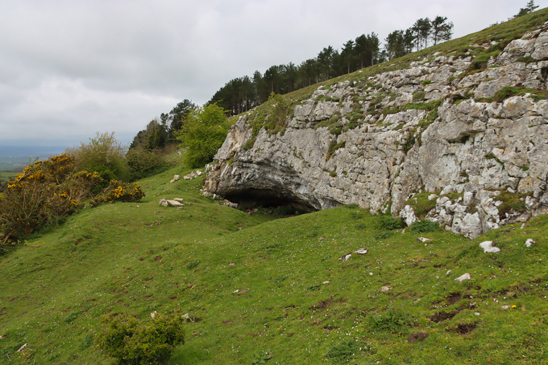
The cairn rising above the tree tops on Gop hill, with the cave visible as a dark line in the light limestone ridge below. Source: Coflein

Gop Cairn is at an elevation of 250m (c.820ft) above sea level  on the prow of a hill overlooking the Vale of Clwyd, just outside the village of Trelawnyd (formerly known as Newmarket).  It is oval rather than round, and measures roughly 101m x 78m (331 x 255ft).  It is the biggest man-made prehistoric mound in Wales, and in Britain as a whole it is second only to Silbury Hill in Wiltshire.

The cave has already been discussed in part 1 (Pleistocene and Mesolithic) and part 2 (Neolithic burials).

The Excavation

The plan of the cairn and excavations by Boyd Dawkins. Source: Boyd Dawkins 1901

Sir William Boyd Dawkins was hired by the landowner to excavate the cairn.  Boyd Dawkins had a simple, though labour-intensive strategy.  The plan that Boyd Dawkins made of the cairn shows the dip in the top that remains today.  Boyd Dawkins speculates that this could have been caused when the cairn was later used as a source of raw materials for local drystone walling, or alternatively by subsidence due to the collapse of an underlying chamber.

Although there is a thin covering of vegetation today, the cairn was found to be built of chunks of limestone.  Around the base of the cairn there seems to have been a more organized and well presented kerb of drystone walling.  Ian Brown suggests that when first built, and during the period when it still retained importance, it may have “shown a dramatic whiteness set against a blue or darkening site.”  The limestone ridge below, in which the cave is located and shown at the top of this post, certainly seems almost white in the sunshine, and the cairn may have had a similarly noticeable appearance, particularly given its great size.

Boyd Dawkins sunk a shaft (6ft 6 ins by 4ft / c.2m x 1.22m) vertically from the top of the cairn, which had to be shored up with timber to allow work to proceed safely.  The shaft reached the former ground surface, which was formed of bedrock.  A main “drift” (a mining term for a horizontal subterranean tunnel) was then tunnelled running 30ft (c.9m) to the northeast from the bottom of the vertical shaft towards the edge, followed by two shorter drifts.  The hope was to find a burial chamber at the centre.  It was not unreasonable to assume that there would be a burial chamber of some description.  Although Neolithic chambered cairns are not common in northeast Wales (examples are Tyddyn Bleiddyn near St Asaph and Tan y Coed in the Dee valley), there are many Early Bronze Age round barrows with cists, and there are several stone-built burial sites and a stone row on the Great Orme to the west.

Unfortunately, in spite of all the hard work, all that Boyd Dawkins and his team found were fragmented animal bones, which in spite of his considerable experience identifying animal remains, Boyd Dawkins was unable to identify with certainty: “hog, sheep or goat, and ox or horse, too fragmentary to be accurately determined.”  Overall, the suggestion is that these were domesticated species that could have been herded or penned in the area.

No artefacts were found.

Conditions were obviously very difficult, as Boyd Dawkins states: “The timbering necessary for our work was not only very costly, but rendered it very difficult to observe the condition of the interior even in the small space which was excavated.”  It is possible that the chamber, if there is one, is off-centre, and that any passage leading to it is in a different direction.  Until further survey or excavation work is carried out, there is no means of telling what lies beneath the surface.

Dating the Cairn

Neolithic arrowheads found on Gop Hill. Source: Glenn 1935

Data for the dating of the cairn is circumstantial.  Although domesticated animal species were found within the cairn, these could have been deposited at an any time from the Neolithic onwards.  On the other hand, arrowheads and other Neolithic stone tools have been found on Gop Hill. According to T. Allen Glenn in 1935, Gop Hill was known locally as Bryn-y-Saethau, the Hill of Arrows, due to the large number of Neolithic arrowheads found there over the decades.  Just below the cairn, just 43m (141ft) away, shown in the above photograph, is a shallow cave in the limestone ridge  that contained Neolithic burials.  There are ephemeral Neolithic sites nearby, identified by T. Allen Glenn during field walking during the 1920s, and there are other Neolithic cave sites in northeast Wales.  At the same time, nothing significant relating to the Bronze Age has been found in the immediate area.  Although Iron Age and Roman sites have been found in the area, Gop Cairn is not an Iron Age or Roman form of site, and there is no record of a medieval motte and bailey castle up on the hill.  On balance, accepting that it remains speculative, it seems probable that it will turn out to be a Neolithic site if it is ever properly investigated.

Myth: “Baseless Theories”

A local writer named Edward Parry, author of Royal Visits and Progresses into Wales, written in 1851, propagated the idea that Gop Hill and its cairn were connected with the battle between Boudicca and Suetonius Pauluins in A.D. 61.  It is a bizarre theory, that Ellis Davies, under the subheading “Baseless Theories” says in 1949 was a “false derivation” based on one of the names of the Gop, Cop Paulini.  It is otherwise incomprehensible why Parry should have come up with the theory, but it found its way into other pamphlets and local accounts.  As Davies points out in a rather aggrieved tone, “It would not be necessary to refer to these absurd stories about the association of Boudicca with Gop and neighbourhood were it not for the fact that locally they still persist!”

The Beacon

In his 1949 book “The Prehistoric and Roman Remains of Flintshire,” Ellis Davies notes that in the 17th century there was a beacon on Gop Hill, the purpose of which was to send up an alarm, when necessary, should pirates be spotted off the coast.  A small hut was built at the bottom of the cairn to store the combustible materials with which the fire would be lit.

Final Comments

It is a little ironic that there is such a lot to say about a rather small cave, and not a great deal to say about an absolutely enormous cairn on the prow of a hill that dominates the surrounding landscape.  It seems clear from the burials in the cave beneath the cairn, dated by association with distinctive artefacts, and supported by stone tools found on the hill, that this was an important location during the Neolithic. It seems likely that the cairn could have belonged to the same period, but it is also possible that it could belong to the following earlier Bronze Age.  Further investigation will be required to nail down the date of the site, and to establish if there are any additional structures, such as burial chambers, contained within.


Suggestions for the derivation of the name Gop. Source: Ellis Davies 1949, p.159

Sources and visiting details are shown in part 1


Gop Cave and Cairn near Prestatyn # 2 – The Neolithic burials

Part 2 – The Neolithic burials in the cave

Introduction

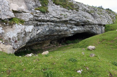
Main entrance to Gop Cave

In Part 1 I looked at the excavations carried out at Gop Cave in 1886-7, 1908-14, 1920-21 and 1956-57 and talked about the pre-glacial levels of Gop Cave, with its finds of woolly rhino, hyaena and wild horse, and the Mesolithic tools found outside the cave mouth.

In this second part, the cave is still the topic under discussion, with a shift in focus to the Neolithic layers, whilst the cairn on top of Gop Hill is tackled in part 3.  During the Neolithic, the cave was used to deposit a number of burials, two thirds of which were contained within a walled-off section of the cave, and the rest within a narrow passage that linked two parts of the cave.  These burials are the subject of this post.  References used for all three parts are listed in part 1, together with visiting details.

The Excavations

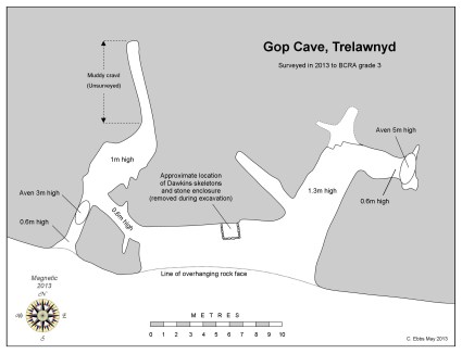
Modern plan of Gop Cave by Cris Ebbs. Source: Cambrian Caving Council Survey 2013

Just to recap briefly on the details from part 1, the earliest excavations in the cave were carried out by Sir William Boyd Dawkins, a well known and respected early archaeologist who excavated the cave site over two seasons in 1887 and 1887, having originally been asked to assess the cairn on top of the hill.  The lowest level was barren , but the next contained numerous bones of Pleistocene animals, many of them now extinct.  The top two layers contained mainly Neolithic material including human skeletal remains.

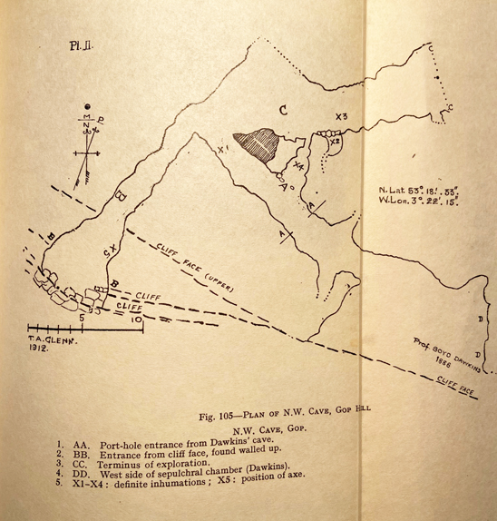
In 1908 John H. Morris began digging at the cave, and was joined by T. Allen Glenn, who took systematic notes and made a plan of the newly uncovered sections of the cave.  They opened up a passage missed by Boyd Dawkins, referred to as the northwest passage, which linked to a very small opening just to the east of the main cave entrance.  During these excavations a further six partial skeletons were found, two of them children.  The skeletal remains in both cases were associated with artefacts and animal bones.

Most of the bone collection collected by Boyd Dawkins, and stored in a pigeon house at Gop Farm, were disposed of in 1913 by the tenant of Gop Farm, who threw them down a local mine shaft – which is particularly sad as Glenn had just received permission to take charge of them.  Most of the Morris and Glenn finds, both bones and objects, were sent to the National Museum of Wales.  Some finds from Gop Cave are also retained by Manchester Museum and Aura Museum Services, and possibly by the Grosvenor Museum in Chester.

The Neolithic burials at Gop Cave

In total, at least 20 individuals were recorded in Gop Cave.  The 14  found by Boyd Dawkins and the 6 found by Morris and Glenn may have been deposited at slightly different times, due to the different character of the deposition.  Whereas the individuals discovered by Boyd-Dawkins  seem to have been buried whole, Glenn is fairly confident that the ones discovered by himself and Morris in a different part of the cave were only partial when they were interred.

Boyd-Dawkins excavations showing the chamber (feature B) above layer 3 and abutting layer 4, which contained skeletal remains of humans with artefacts. Source: Boyd Dawkins 1901.  See other cave plans in part 1.

Dawkins describes how he found a thick layer of charcoal over slabs of limestone at a depth of 4ft (c.1.2m) from the surface, which formed an old hearth.  Blackened slabs were found throughout the area excavated, and there were also burnt and broken bones of domestic animals and fragments of pottery.  “Intermingled with these were a large quantity of human bones of various ages, lying under slabs of limestone, which formed a continuous packing up to the roof.  On removing these a rubble wall became visible, regularly built of courses of limestone.”  These limestone blocks made up walls on three sides, with the cave wall itself making up the fourth wall, to form a chamber 4ft 6 by 5ft 4 (c.1.4m x 1.65m).  Inside the chamber was what Dawkins describes as “a mass of human skeletons of various ages, more than fourteen in number, closely packed together, and obviously interred at successive times.” Individuals were deposited in a crouched position, “with arms and legs drawn together and folded.”  His assessment was that the bodies were buried whole. When the chamber became full, another area of the cave was used as an overflow for new burials, identified on the section plan above as area A.  Because layer 3 was found beneath the burial chamber, as well as beneath layer 4, Boyd Dawkins concluded that layer 3 had formed a habitation area prior to the burials, in a similar way to two other cave sites in north Wales.

Glenn’s plan of the 1912 excavations. Source: Davies 1949

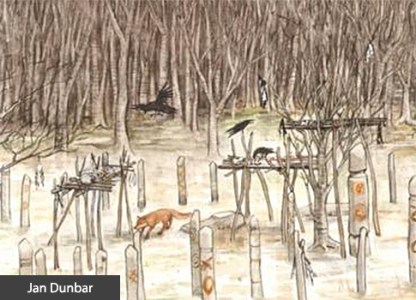
When Morris and Glenn opened up another passage, and found another six individuals, Although the view was confused by rock fall and a very uneven floor, it was thought that limestone slabs may have been used to create a wall around some of the skeletons.  Glenn describes the bones as fragmented and partial.  Glenn ascribes this to the remains having been brought from somewhere else, rather than having been depleted due to roof fall damage of fragile bones, or the work of the “burrowing animals” that caused disruption in the stratification within the passage.  He was methodical and a good observer, so presumably had good grounds for suggesting this, and it is certainly in keeping with other, more recent archaeological evidence for Neolithic burials where partial skeletons are found, apparently due to having died elsewhere and been moved to a particular site for burial.  Another possibility is that the body had been excarnated, a practice involving the ceremonial placement of a body in the open air to allow it to be processed naturally so that it was defleshed and partially disarticulated before being collected for interment, which often resulted in the bigger longbones and crania being collected whilst finger and foot bones were left behind.

Having opened the cave out and discovered the second entrance, Morris and Glenn found that it was blocked with limestone slabs, apparently deliberately, although it is by no means certain when this was done.  It is not unlike the blocking of entrances to Neolithic burial monuments towards the end of the Neolithic period.

The artefacts associated with the burials

Polished blade found by Boyd Dawkins in Gop Cave. Source: Dawkins 1901

The artefacts associated with both sets of skeletons are all Neolithic in date.  Boyd Dawkins assigned them to the Bronze Age on the basis of the pottery, but this has since been re-dated. Both the Boyd Dawkins and the Morris and Glenn excavations produced stone tools, most of which are fairly generic but can be assigned to the Neolithic.  One of the Boyd Dawkins discoveries was a long, curved blade, very carefully carved and polished to provide it with smooth surfaces, and showing no signs of usage.  He also identified quart pebbles, which he refers to as “luck stones.”  Another notable stone tool, this time found by Harris and Glenn in the part of the cave undiscovered by Boyd Dawkins, was a bifacially worked axe head made from Graig Lywyd stone from the well-known Neolithic stone mines at Penmaenmawr, which was apparently unused.

Objects found by Harris and Allen in Gob Cave, including the Graig Lwyd axe at top. Source: Davies 1949.

The pottery was Peterborough ware, and it has been determined that the Gop Cave type was the Mortlake variant of Peterborough ware,  which dates to between about 3350 and 2850 BC.  All were fragments, and were either grey or black or burnt red.

Pottery found in association with the skeletons by Boyd Dawkins, since identified as Mortlake Ware. Source: Boyd Dawkins 1901

Kimmeridge sliders. Source: Boyd Dawkins 1901

Two unusual items were referred to by Boyd Dawkins as “links,” which he thought were proably used to fasten clothing, and are referred to by some others as belt-sliders.  He described them as being made of “jet or Kimmeridge coal,” or “Kimmeridge shale.”  As these items are now lost, they cannot be tested (they were last known to be in Manchester Museum, but now cannot be found).  He gives the measurements as 54mm L x 22m W and 16mm H; and 70mm L, 22mm W and 27mm H.  Boyd Dawkins says that they showed no signs of any usage, and according to Alison Sheriden’s analysis of these object types, this is typical.  They appear to have been kept for show rather than being attached to clothing or employed in some other everyday capacity, much like the curved blade and the Graig Lwyd axe head.  As jet and Kimmeridge coal come from Yorkshire, and a third of all known sliders have been found in and around Yorkshire, they are certainly exotic goods in northeast Wales, and the rarity of the substance may have endowed it with a particular cachet.  Jet has the very unusual property of being electrostatic, so that when it is rubbed it can make one’s hair stand on end! If it was jet, this would certainly have added to its novelty value.   29 of them were known when Sheriden was surveying them in 2012, of which only 6 were certainly of jet, one of which was found in Wales.  12 or 13 were from burial contexts and distribution showed  “a marked tendency towards coastal and riverine finds” that are a reminder of the extensive networks that operated in the Neolithic. 

Although the objects in the cave are few and far between, some were unused suggesting that they highly valued and retained for special occasions or as prestige items.  It is unclear whether any artefacts were associated with any particular individuals, although Boyd-Dawkins describes the the jet sliders and the polished flint flake forming one group together.

Animal remains

Although he does not list numbers, Boyd Dawkins says that the remains of the domesticated species “were greatly in excess of those of the wild animals, and the most abundant were those of sheep.”  He also comments that the horse listed under wild fauna may actually be domesticated, and that foxes were using the vicinity of the cave area at the time of the excavation.  All bones were found in what he describes as “prehistoric refuse heaps and that nearly all were broken and burnt.


As all the bones were discarded in 1913, none of the identifications can be checked, but Boyd Dawkins was very experienced in the identification of animal remains, giving some confidence that his work reflected the reality of the situation.  Sheep and goat are notoriously difficult to tell part, so the question-mark against goat is not surprising.  That sheep are dominant is not a surprise, as the area around Gop would be ideal grazing for them.  The valley bottom would have been well-suited for cattle and horse.

Dating the skeletons

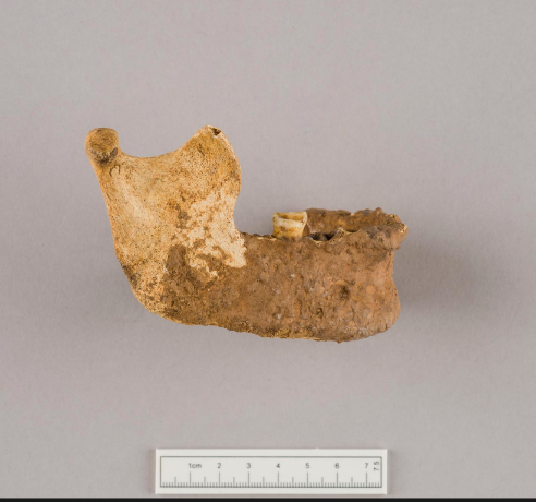
Mandibles used in radiocarbon dating of Gop Cave skeletons. Source: Schulting 2020

Although the artefacts found in the cave, loosely associated with the skeletal remains, are indicators of a mid-Neolithic date, as described above, in 2020 Rick Schulting was able to pull together 23 samples from a number of caves for radiocarbon dating, including three samples from Gop Cave, comprising two mandibles and one cranium.  Although some samples had been tested previously, an error in the sampling method had led to them being withdrawn in 2007.  For Gop, the new dates lie firmly with the Middle-Late Neolithic range, tending towards the middle of the Neolithic (between c.3100 and 2900 BC).

This date range backs up the findings of the Mortlake variants of the Peterborough ware, the jet sliders and the Graig Lwyd axe.

The practice of non-monumental burials

The main form of burial recognized throughout most of the Neolithic Britain is the long barrow or cairn, or the round passage grave.  In each case, there was usually an accumulation of burials over time, referred to as collective burials.  These were not, however, the only forms of burial during the Neolithic. Although less often found, because of the lack of monumental marker, flat interment cemeteries are known, burials in the ditches of the so-called causewayed enclosures are often recorded and there is some, uncertain data that there may have been burials in rivers.  During the later Neolithic, cremation became the norm.

Jawbone of skeleton from Gop Cave. Source: National Museum of Wales (47.97/104)

By far the most common non-monumental form of burial, however, is deposition within a cave.  Cave burials of various dates are known from all over Britain.  In his survey of cave burials in 2020, Rick Schulting noted examples from the Palaeolithic through to the Anglo-Saxon period.  From the Neolithic in north Wales, contemporary with Gop Cave, nearby Nanty-Fuach rock shelter above Dyserth produced five burials, all contracted, and without grave goods.  Outside the cave there were fragments of Neolithic pottery, a large barbed and tanged arrowhead and, nearby, some Peterborough ware.  In the Alyn valley 16 burials were deposited within Perthi Cawarae, and 6 within Rhos Ddigre, the latter associated with a Graig Lwyd axe and pottery fragments, both in the Alyn valley.  Other examples are known from Loggerheads and Mostyn with Neolithic flint implements.  It is clear that Gop Cave is by no means an isolated example, although the precise arrangement of the skeletal remains within containing walls may be unusual.  As many caves were excavated in the late 19th and early 20th centuries, when excavations lacked today’s precision, it is impossible to know what was missed by excavators.  Finally, Schulting notes that there is a gap of “several millennia” between the last Mesolithic cave burial and the first Neolithic ones, indicating that there is no continuity of burial tradition in caves between the two periods.

Meaning in collective burial

Frances Lynch suggests that the use of caves for burial, occurring in many areas at different periods “seems to be  a matter of convenience rather than cultural preference” but there are alternative views on the matter.  In his book on the materiality of stone – Christopher Tilley does not discuss caves, but he references almost every other aspect of stone as a natural material that becomes objectified by human uses and actions.  He comments that social identity requires “specific concrete material points of reference in the form of landscapes, places, artefacts and other persons.” Topographic and other natural features are often used by humans to anchor and fix memory and establish places of meaning in landscapes.  Carole Crumley highlights the phenomenological experience of features like caves, mountains and springs, and their role in connecting the mental with the material to create both individual and social identity.  In their chapter on the uses of landscape features like caves and springs by the Maya in Mesoamerica, James Brady and Wendy Ashmore describe how caves, eternally damp and dripping water, were connected with the sacred and the ritualization of water. By appropriating and modifying such natural features, people have embedded them with meaning to form bridges between the natural, supernatural and the manufactured, blurring the differences to confer special status on these dark places where the dead might be deposited safely.

Artist’s impression of what an excarnation platform might look like. By Jan Dunbar. Source: BBC

A number of authors have suggested that collective burial of humans, and in particular the mingling of bones rather than maintaining skeletons as delineated individuals, is an indication of the individual being subsumed into a collective identity, privileging the group identity over the authority or status of any one individual.  Of course, these collective burials, whether in monument or cave, are representatives of much larger communities, and the criteria used for selecting one person for burial over another are lost.  It is possible that in order to transform an individual into a representative of the community, a two-stage process was undertaken whereby an individual is excarnated or buried elsewhere, and then moved to a collective burial site, a transformative process during which the individual member of the community loses their individuality and becomes representative of a communal and ancestral link between the past and the present.   With the addition of each new individual to the cemetery, another layer of communal meaning was added to the cave, reinforcing the message that the existing burials already encapsulated.

In the contrast between the brightness of the light-coloured limestone reflecting in the sun, and the darkness of the hidden, secret interior there is a resemblance between the relationship between the visually striking chambered tomb and the sepulchre within.  Not forgetting, of course, that there is an enormous cairn on top of the hill, just 43m (141ft) away from the cave, which may in itself have been a marker rather than a grave.  The cairn is discussed in part 3.

Final Comments

Neolithic stone implements found in and near Gop Cave. Source: Davies 1949, p.283

Gop Cave is often left out of accounts of the Neolithic in Wales, or merely mentioned in passing, which is surprising given both the number of its human occupants and the unusual combination of artefacts found within the cave.  Cave burials are given secondary status to monumental constructions, but given the number of them in Wales, it is good to see that they are now being researched as valid contributors to the corpus of knowledge about the Neolithic both in Wales and the rest of Britain.

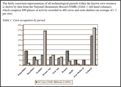
Graph from Jonathan Last showing the usage of caves at different periods in England (The Archaeology of English Caves and Rock-Shelters: A Strategy Document. Centre for Archaeology Report 2003)

Sources and visiting details are in part 1


Gop Cave and Gop Cairn near Prestatyn – # 1: Woolly rhinos and hungry hyaenas

Introduction

Gop Hill in northeast Wales, a few miles southeast of Prestatyn, and just above the village of Trelawnyd (formerly Newmarket from 1710 to 1954) is home to Gop Cave and Gop Cairn, just a few minutes apart from one another.  Gop Cairn has the distinction of being the largest man-made prehistoric mound in Wales, and when approached from a distance, its size really is impressive.  Although the cairn was investigated in the 19th century, with a vertical shaft sunk from the top to the level of the floor, and a “drift” tunnelled outward from the base of the shaft, no burial chamber or human remains were found.

The south-facing limestone cave was also investigated, producing Pleistocene zoological remains, Mesolithic stone tools and Neolithic human burials and contemporary artefacts and the bones of both domesticated and wild animals. In 1868 Boyd Dawkins excavated pre-glacial animal species such as woolly rhino and steppe bison in the cave deposits, which provided significant data about local ecological conditions. Excavations by T. Allen Glenn in the early 1920s discovered Mesolithic remains on the platform outside the cave.  Although this was a small assemblage, it is an important contributor of knowledge about the poorly understood North Wales Mesolithic.  The Boyd Dawkins excavations also produced an unusual and very important Neolithic burial chamber.  It was found in one of the upper layers, with walls made of layers of stone containing at least 14 burials.  Pottery and stone tools found with them were sufficiently distinctive to provide a chronological range, placing the burials within the Neolithic period.  Excavations conducted by John H. Morris and T.A. Glenn between 1908 and 1914 found another six burials in a previously undiscovered passageway, including two children as well as a Neolithic axe-head from the nearby Graig Lywyd axe factory and are considered to lie within the same date range as those found by Boyd Dawkins, taking the total count of individuals found up to 20.  It did not take a great leap of imagination to speculate that the Neolithic date for the cave could suggest a similar date for the cairn, although this remains unverified.

Over three posts, the Gop Hill sites are described and the work carried out summarized.  This post, Part 1, looks at the 19th century excavation of Gop Cave by Sir William Boyd Dawkins, a really rather remarkable early investigator of prehistoric habitats and fauna as well as archaeological remains. Visiting details are provided towards the end of Part 1, after which there is a list of references.  Part 2 looks in detail at the Neolithic burial within the cave, and part 3 looks at the cairn.

Sir William Boyd Dawkins, excavating 1886-1887

When I was working in caves with archaeological deposits in the mid- to late-1980s, 100 years after William Boyd Dawkins was excavating at Gop Cave, he was a very well-known name, and a respected one.  It is easy to be frustrated with the quality of the work carried out in those early investigations, some of which were far from systematic, and caves have some particular quirks of their own to contend with, but a few of these early investigators were impressive and Sir William Boyd Dawkins was one of them.

Born near Welshpool in 1837 Sir Wiliam Boyd Dawkins (1837-1929), developed a keen interest as a child in collecting fossils.  His initial field of interest was primarily geology, natural history and palaeontology, all of which have in common with archaeology a focus on stratified sequences and the relative positioning of fossils, bones and objects within those sequences.  Just as early archaeologists were interested in building up sequences of artefacts so that they could understand how human technology developed, early palaeontologists were interested in the developmental sequence of prehistoric animal and plant species. In 1860 he graduated in Natural Sciences and Classics from Oxford and in 1861 he was appointed to the Geological Survey of Great Britain. Fortunately, because Sir William found many archaeological remains during his investigations, he treated these more recent discoveries with equal interest and respect.  His earliest archaeological excavations were at Wookey Hole in Somerset where he discovered some of the first evidence of Palaeolithic (Old Stone Age) occupation.  These discoveries helped him to develop methodologies for excavating cave sites and to build up a good understanding of the type of environmental and human data that he was likely to encounter within particular geological and geomorphological contexts.  He wrote a number of important articles about extinct sub-species of rhinoceros that had once inhabited Britain. He became the first President of the Lancashire and Cheshire Antiquarian Society and President of the Cambrian Archaeological Association.  He excavated at a number of cave sites in north Wales, and his 1874 book “Cave Hunting: researches on the evidence of caves respecting the early inhabitants of Europe” became a classic.

The four phases of Gop Cave deposits

Figure 5 from Boyd Dawkins 1901, p.327 (the cavity marked as B was the Neolithic burial chamber)

When Boyd Dawkins first encountered Gop Cave, it was full to the brim with glacial, post-glacial and more recent debris and rock fall:

While the cairn was being explored my attention was attracted to a fox-earth at the base of a low scarp of limestone 141 feet to the  south-west of the cairn. It occupied a position which I have almost invariably found to indicate the presence of a cavern  used by foxes, badgers, and rabbits as a place for shelter. I therefore resolved to explore this, with the assistance of Mr. P. G. Pochin. The fox-earth led us into a cave completely blocked up at the entrance by earth and stones and large masses of limestone, which had fallen from the ledge of rock above. This accumulation of debris occupied a space 19 feet in width, and extended along the whole front of the cavern

Nothing loth, he set about clearing it in a top-down methodical way that would allow him to assess the chronological composition of the deposits.  It was a remarkable achievement, given the incredibly limited head space and the absence of more than a thin envelope of natural light.

Figure 4 showing the excavations of the cave in horizontal plan, with the sections through the deposits both outside and within the cave. Feature B is the Neolithic burial chamber. Source: Boyd Dawkins 1901, p.325

Boyd Dawkins identified four distinct phases within the cave.   These are shown in the table below and discussed beneath.  The terms Pleistocene and Holocene used in the table below refer to consecutive periods in the geological timescale.  The Pleistocene begins at around c.2.8 million years ago, covering the most recent period of repeated periods of major glaciation to 11,700 years ago, when the last glacier retreated and the planet entered its present inter-glacial phase, the Holocene. The Holocene levels at Gop Cave, which include the 14 burials (thought by Boyd Dawkins to be Bronze Age but now reassigned to the earlier Neolithic), will be discussed in Part 2.  Below is a discussion of the Pleistocene levels.

Geological Table Source: USGS

Figure 6 from Boyd Dawkins 1901, p.329

Boyd Dawkins noted that the layers were not as they would have been originally deposited: “They appear to have been washed out of the original hyaena floors by the action of water, and to have been redeposited at a time later than the occupation of the cave by hyaenas.”  The presence of stone of non-local origin also argues for different phases of water and glacial activity entering the cave, scouring the deposits and replacing them.

Boy Dawkins identified the Pleistocene fauna from the surviving bones and antlers found in the cave as follows.

  • Cave hyaena – Hycena spelaea
  • Bison – Bison priscus
  • Red deer – Cervus elaphus
  • Reindeer – Cervus tarandus
  • Roe deer – Cervus capreolus
  • Horse – Equus caballus
  • Woolly rhinoceros – Rhinoceros tichorhinus

Woolly Rhino. Source: Science

Woolly rhino (now designated Coelodonta antiquitatis), cave hyaena (now referred to as Crocuta crocuta , and sometimes Crocuta crocuta spelaea) and Bison priscus (steppe bison) are now extinct.  The steppe bison was the species painted in famous Upper Palaeolithic caves like Lascaux in France and Altamira in France.  Although Boyd Dawkins identified horse as Equus caballus, if the identification of horse was correct, it would probably have been the wild ancestor of caballus, Equus ferus. Reindeer are no longer found wild in Britain.  Of the species on his list, red deer and roe deer and horse are the only wild species that remain in Britain.  Boyd Dawkins observed that some of the remains, and particularly the antlers of “the reindeer, bore the teeth marks of hyaenas, and had evidently belonged to animals which had fallen victims to those bone-eating carnivores.”

20th Century Excavations
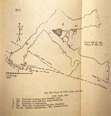
Glenn’s fold-out plan of the 1912 excavations. Source: Davies 1949

Further excavations took place during the earlier part of the 20th Century, contributing more information.

Between 1908 and 1914 John H. Morris and T. Allen Glenn investigated the northwest passage of the cave system, sometimes.  This was missed by Boyd Dawkins because it was hidden behind a blockage of clay and stalagmite.  This passage produced an additional six skeletons, two of which were children.  Glenn describes an excavation “carried out with extreme care and by modern methods” but says that due to burrowing animals there was no recognizable stratification byond determining Pleistocene and Neolithic levels.  The floor was covered to a depth of between 18 inches and 2ft “with cave earth and pieces of limestone over a hard floor of clay mixed with stalactite fragments and limestone rubble” over bedrock.   There is some indication that limestone slabs had been used to build low walls around some of these skeletons.  Finds within the cave, at the new entrance and near the cave between 1911 and 1917 were collected by Morris.  Neolithic human remains and artefacts were found, and will be discussed in Part 2.  Animal remains found were horse, sheep/goat, ox, pig, wolf, fox, bear, lynx, badger, fowl, hare, rabbit, frog, watervole, mole, stoat and fieldmouse.  The mixture of Pleistocene and Holocene species suggests that these were highly disturbed layers, probably due to the activity of burrowing animals mentioned by Allen.

The excavations linked the passage in which they were working to the second entrance, the very small opening for which is a little further along the ridge to the west, and shown on the plan at the top of this post. This is sometimes referred to as the North-West Cave, although it is part of the same cave system as the main Gop Cave.
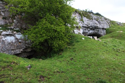
Both cave entrances in the limestone ridge.

T. Allen Glenn returned to the site between 1920 and 1921, funded by the National Museum of Wales.  He excavated the platform in front of the cave, which was largely untouched by Boyd Dawkins and found more human and animal remains, as well as Mesolithic stone tools, described below.  Glenn wrote up both his own and Morris’s excavations in one 1935 report.

In 1956 William H. Stead excavated at the site and amongst other animal remains found a lion tibia.  The reports are in the Proceedings of the Prehistoric Society, nos 23 (1957), 28 (1958) and 29 (1960).  Although I have listed them in the bibliography, I don’t have access online via the University of Chester, and the library does not have these volumes on the shelves, so I have been unable to read up on the findings.  If I get hold of them (please give me a yell if you have access to them!), I’ll update this section.

Dating the animal remains in the Pleistocene cave

Gop Cairn with the cave entrance visible on the limestone ridge just below.

There were only certain periods when Britain was actually habitable.  One reason is that harsh climatic conditions during glacial periods forced most life to leave all but the most southern areas.  For example, between c.160,00 and 80, 000 years ago the environment was too hostile for human occupation and for most animals.  Another reason is that, after 130,000 years ago the permanent chalk land-bridge between Britain and Europe was destroyed, and after this time Britain and Europe were only connected during glacial periods when the water level dropped sufficiently for land-bridges to be revealed, which enabled animal and human migratory movement.  Modern research into the climatic and environmental past has helped to clarify when land bridges between Europe and Britain enabled animals and humans to wander freely. With the final retreat of the ice sheets at around 10,000 BC the land bridges were permanently submerged. De Groote et al explain this very clearly:

Generalised reconstruction of the land surface and the extent of ice sheets of the British Isles. Source: De Groote et al 2017, fig.1 p.3

From the early Pleistocene, Britain was connected to main-land Europe by a land-bridge that enabled humans and fauna to migrate in and out (Fig. 1A). Until about 130,000 years ago, this narrow chalk isthmus, separating the north (North Sea) and southwest (English Channel) marine embayments, kept Britain connected to varying extents even when sea-levels were high during the warm interglacial periods; the eventual complete breaching of this chalk barrier was crucial in forming the island and the Dover Strait. During glacial periods, much of the earth’s water would have been trapped in the ice caps and when, during the later Pleistocene, the bed of the North Sea was exposed, a large land area known as Doggerland, created by geological uplift and sedimentation from rivers, also provided a route into the British Isles and fauna, including hominins, would have entered this way. The flooding of the shallow shelf areas of the English Channel and the North Sea are the consequence of the current high interglacial sea levels.

Even without modern scientific dating methods, reliable time-ranges can be assigned to animal bone assemblages on the basis of which species were found together in a certain place during a certain period. Boyd Dawkins had already assembled a considerable amount of data on the subject, some of which was published in his earlier work Early Man in Britain published in 1880.
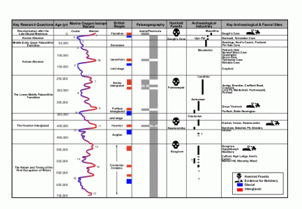
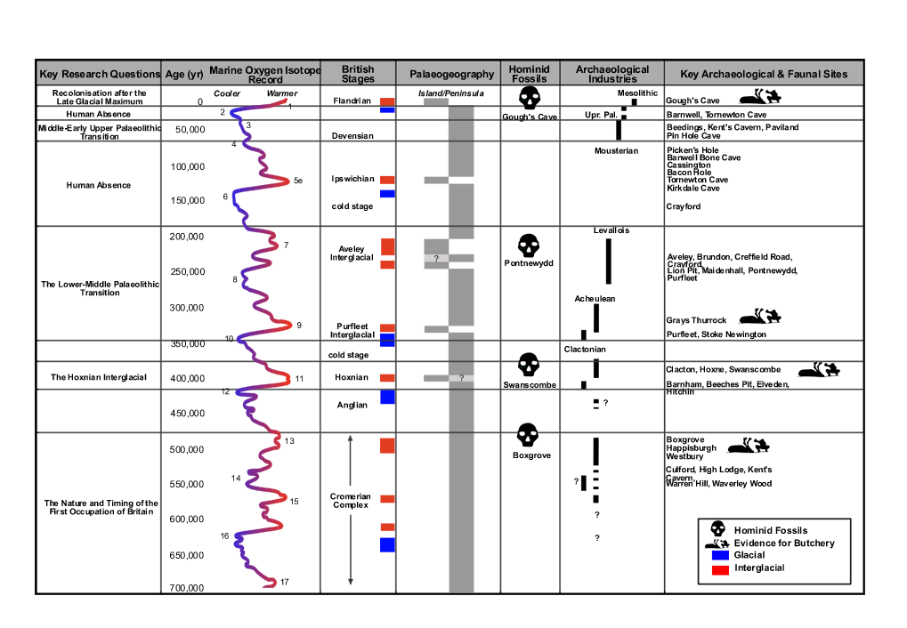
AHOB time chart showing periods of human absence and occupation. Click to enlarge or see original on the AHOB website

Improvements in palaeo-zoology have helped to clarify which species were present during which periods.  Some animals that are now either completely extinct or permanently migrated out of Britain provide a latest possible date for their presence.  Studies of prehistoric assemblages of fauna have also helped to fix date ranges for the presence of certain species, assigning them to marine isotope stages (also known as oxygen isotope stages).  Marine isotope stages measure oxygen isotopes in sea water that is absorbed into the skeletons of tiny single-celled organisms called foraminifera, which are preserved in sediments on the sea floor.  The oxygen isotopes contain information about the volume of ice present globally, and therefore provide a record of alternating glacial and interglacial periods. The faunal assemblage corresponds well to MIS 3, which falls into the Middle Palaeolithic archaeological period.  Woolly rhino, for example, had left Britain by around 30,000 years ago.  The entire assemblage probably puts Gop Cave in Marine isotope stage 3 (MIS 3).  MIS 3 lasts from between 60,000 and 25,000 years ago. The conditions were ideal for woolly rhinoceros, horse, bison, hyaena, and reindeer, which inhabited temperate but cold semi-arid steppe-like conditions with often hot summers and very cold winters.  Steppes are characterized by wide open treeless grasslands, with small shrubs, ideal for grazing species, and for carnivores preying on the grass-loving herbivores.

Pontnewydd Cave entrance. Source: National Museum of Wales

Even though the idea of woolly rhino, bison and hyaena roaming the hills of north Wales, all of them now extinct, may seem distinctly exotic, these time ranges are not particularly early for Britain.  Not far away, near St Asaph, the cave site of Pontnewydd produced stone tools and human remains in association with animal species for which sound scientific dates were obtained during modern excavations.  The human remains found in association with stone tools belonged to the branch of hominin known as Neanderthal (Homo neanderthalensis, named for the type site in the Neander Valley in Germany) and the dates cluster around 225,000 years ago.  If correct, the Gop Cave date ranges are relatively recent by comparison.

Although MIS 3 corresponds to periods of human occupation in Britain during the Middle Palaeolithic there was no human habitation identified within the Pleistocene levels of the cave.  Boyd Dawkins was experienced at identifying human artefacts and would almost certainly have recognized them had any been there to be found. a number of brief occupations of the country, Britain would have been occupied intermittently during this time, depending on the environmental conditions, and probably only by small groups.  The most probably candidate for any humans dodging lions and woolly rhinos and competing with hyaenas for dining on deer, may have been Homo Neanderthalensis (Neanderthals).  The oldest Neanderthal find in Britain was from Swanscombe in Kent, where a skull dates to c.400,000 years ago, a warm interglacial period.  Neanderthals left and re-entered Britain numerous times, their movements determined by glacial and interglacial conditions, until around 40,000 years ago when the Neanderthals became extinct.

The Mesolithic

Microliths from Gop Cave, excavated by Glenn in 1920-21. Source: Wainwright 1961

The Mesolithic, corresponding to the geological Holocene, represents settlement during the earliest post-glacial period.    Although the site was small, the Gop artefacts are very typical of Mesolithic finds in the area.   The stone tools found included 6 microliths (tiny stone tools usually 3cm or less long), a scraper, two other tools of undetermined types, possibly waste flakes, and twenty three microlith and blade cores.  A core is the original piece of stone after it has been worked.  When microliths, flakes and blades have been struck from it it is discarded, but still bears the marks of the tools that were removed from it.  Of the microliths, Geoffrey Wainwright describes two were obliquely blunted, two lanceolate, and four scalene triangles.  There was also one broad point retouched on both sides and a section of a bone pin.

Distribution of Mesolithic sites in Wales. Source: Heneb Dyfed

The earliest known Mesolithic site in Wales dates to c.8600 BC (some 10,500 years ago) at The Nab Head in southwest Wales (no.5 on the map to the right).  In 2021 a 9000 year old site was found on Castle Hill, off Hylas Lane in Rhuddlan, where over 13,000 stone tools and five decorated stone pebbles were found. Another well known site is at Trwyn Du on Anglesey where a Mesolithic occupation dates to between 8,000- 9,000 years ago, and was preserved beneath Bronze Age burial mound excavated when it was threatened by coastal erosion in 1974 (no.9 on the map).

With the withdrawal of the ice sheets, vegetation re-established itself, and whilst the land-bridge remained in tact, animals once again drifted across the land, with humans in their wake.  Once the ice had fully retreated, the land-bridge was submerged and Britain and Ireland became separated both from the continent and from each other.  The island was soon occupied by many small groups exploiting inland and coastal resources, hunting, collecting plant resources, fishing and collecting shellfish.
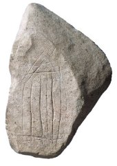
Decorated stone pebble from the Mesolithic deposits at Rhuddlan. Source: Dyfed Archaeology

Warmer and wetter than today, with a deciduous woodland landscape, the environment favoured different wild animal populations from the pre-glacial period, which required different hunting techniques.  Particularly characteristic of the Mesolithic toolkit was the microlith, a catch-all term for a large number of varieties of tiny stone artefact that could have been hafted into wood, bone or antler to make arrows, spears, harpoons and scythes.  Many Mesolithic communities were located on or near the the seashore. The seashore was a movable feast at this time as a) the ice continued to melt, raising sea levels, and b) land, which had been compressed under the pressure of the ice, began to rise.  The exploitation of marine resources included both fish and shellfish.  It was these settlers who, stranded on an island when the land-bridge was lost, were sufficiently stable and persistent to contribute to modern DNA.

Although permanent amelioration of the climate provided the ability to develop new patterns of living eventually lead to the expansion of populations and the modification of landscape, sites are difficult to locate, some were submerged during rising sea levels, and many are often highly disturbed, meaning that the period is still poorly understood.  Each new site therefore contributes important data to the overall picture, and Gop Cave contributes information about where such sites were to be found in north Wales and what sort of activities were pursued.

The location of the finds today

Neolithic stone implements found in and near Gop Cave. Source: Davies 1949, p.283

Davies, writing in 1949, says that most of the animal and human bones from the Dawkins excavations were stored at the pigeon house belonging to Gop Farm, but that some of these were sold in around 1912 to an archaeologist in Wrexham.  Davies himself saw “great quantities of bone” in the pigeon house in 1913 but in the same year, although T. Allen Glenn, who had excavated at the cave, had received permission from the estate manager to remove the archaeological remains, the tenant threw all of it “down an open mine-shaft nearby.”  He goes on: “In a letter dated, ‘The Manchester museum, The University, Nov.19, 1937,’ the keeper, Mr. R.U. Sayce, M.A., supplied the information that there were in the museum several of the remains from the cave; they included animal bones, human skulls, and limb bones; also some sherds of Neolithic ‘B’ pottery. The long flint implement and the Kimmeridge clay links have not been traced.”  The pottery, the flint implement and the Kimmeridge objects relate to the cairn and will be discussed in part 2.  Davies also says that the finds from the objects retained by Morris at his home in Rhyl (where Davies was able to inspect them) were bequeathed to the National Museum of Wales.  Those from the subsequent Glenn excavations in 1920-21 were also deposited in the National Museum of Wales, who had funded Glenn’s work.

According to Cris Ebbs, on the Cambrian Caving Council website, other zoological and archaeological remains that were not disposed of are now in the collections of Aura Museums Service, Grosvenor Museum in Chester.

Conclusions
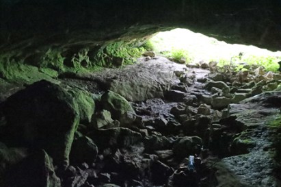
Although there were no human remains in the Pleistocene levels of Gop Cave, the faunal remains provide a fascinating insight of their own into the environmental conditions of north Wales, suggesting that a steppe environment prevailed, possibly at some stage between 60,000 and 30,000 years ago.  Understanding of the palaeozoology, palaeoecoloy and archaeology of the Pleistocene are all dependent on the work of palaeanthropologists, geologists, geomorphologists and climatologists, and many other specialists, all contributing very specialized research about how and when animals and humans would have been able to migrate to and from what is today an island.

The Mesolithic remains are the earliest evidence of human settlement in the immediate vicinity of the cave.  Although they represent a small group of people probably passing through, with no signs of seasonal returns to the site, this helps to contribute to the fragmentary picture of what was happening in Wales in the post-glacial period.  Both tools and tool cores were found, suggesting that tools were manufactured during the short stay at the site.


Visiting Details

When packing your rucksack or stuffing your pockets, do be sure to take a torch with a good, strong beam, and wear some solid footwear that will cope both with slippery mud and some very irregular stones and sharp rocks underfoot in the cave itself.  Caves are nearly always dripping with water, so unless it has been a very dry period, you may want to have a waterproof ready to drag on.  You cannot stand upright in the entrance of the cave, so you enter bent over, but it does open out so that you can explore some of the cave upright.  It is a good idea to get a sense of the internal plan before you go, because the dark is very disorientating and it is quite difficult to make out what is where.

The village of Trelawnyd showing the locations of the car park (red rectangle), and the small lane that leads to the footpath (red arrow). Click to expand.  Courtesy Apple Maps.

Gop Cave is a short walk from the village of Trelawnyd on the A5151 (itself a short drive from junction 31 on the A55).  It is a two-for-one scenario, as immediately above Gop Cave and only a minute or two away, and visible for miles around, is Gop Cairn.  I forgot to to take a What3Words reading for the cave, but the cairn is at ///searcher.sprint.wins,  Both are on public footpaths and are free of charge to access.  There is a car park on the little High Street in Trelawnyd, just off the A5151, or there is a limited amount of on-street parking a bit closer to the start of the small lane that leads to the footpath on the hillside, just up the slope from the car park.  The footpath is clearly marked, as shown in the photograph below.

The first part of the footpath is a small lane that takes you past a couple of houses, until it reaches a narrow path that makes its way along the side of a tall garden fence to your right.  This turns abruptly right and slightly uphill, leading to a low stone-built stile which takes you on to the hillside.  I was with Helen Anderson (well-known on Twitter as @Helenus_) and we were busy nattering and wild-flower spotting (complete with wild orchids) so weren’t paying too much attention to the pathway markers, but they are there if you keep an eye open.

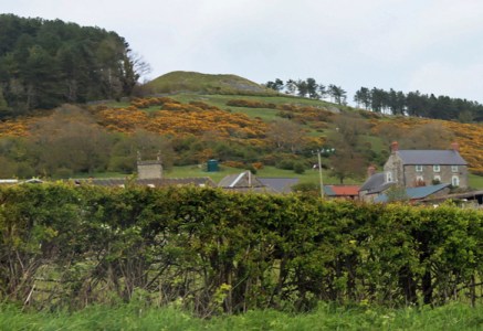
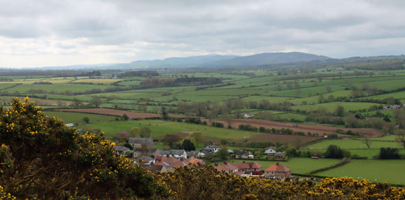
We followed the well-worn track, which leads at this time of year, late April / early May, through bright yellow gorse until it opens onto higher ground, which is completely open, with stunning views over the surrounding valley to Iron Age hillforts on the Clwydian range and to the sea to the west.  You need to turn left beneath a shallow pale grey limestone ridge to reach the main cave entrance.  A very tiny secondary entrance is a little further along.  Retrace your steps to go up to the cairn, through a gate in a drystone wall.  For anyone wanting to stop for a breather, there’s a bench near the gate, somewhat bizarrely looking like an escapee from a Victorian arcade or promenade.
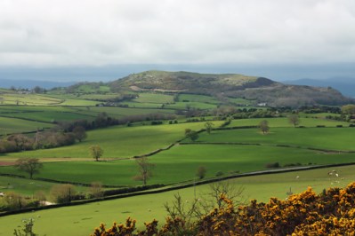
Moel Hiraddug

Although the walk is slightly steep for a short section, it is a mellow walk, and far from strenuous and there are some great views across the valley.  It took perhaps 10 minutes from the road to the cave, 15 minutes maximum, and another five minutes or so from the cave to the cairn.  The cave itself requires you to duck down and be very careful both to watch your footing on a very uneven and rocky surface, and to mind your head.  Best to leave your rucksack outside after liberating your torch.

If you are interested in the Iron Age heritage of the Clwydian Range, Moel Hiraddug is beautifully clear to the southwest, and other hillforts of the Clwydian Range, fading into the distance when we were there, are easily visible on a clear day,

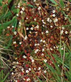
The wildflowers were an added bonus, with a classical karst mix of tiny hardy species clinging to the almost non-existent topsoil above the limestone bedrock, including some really pretty succulents and lichens.  The Early Purple Orchids (Orchis mascula) were a particular bonus, and apparently fairly common in early spring  in the general area.  As well as the miniature slipper-orchid shaped flowers clustering at the top of the stems, their long pointed green leaves often have dark aubergine-coloured spots along them.  Read more about them on the Woodland Trust website.

Having visited, there’s the option of a very good lunch at The Crown Inn in Trelawnyd, which was filling up rapidly during our visit.  After lunch we went on to see the gorgeous Dyserth waterfall only a few miles away, which is very close to the road (a 50p honesty fee was required for access), and then went on to visit the small but fascinating Prestatyn Roman bath-house, which was again nearby.   I have posted about the bath-house here.

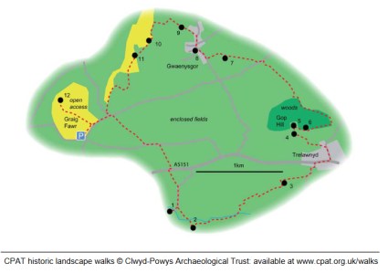
If you want to incorporate Gop Hill into a much longer walk (4-7 hours over 5miles / 10.5 kilometers) the Clwyd and Powys Archaeologial Trust has published what looks like an excellent one: https://www.cpat.org.uk/walks/gopcairn.pdf
Sources for parts 1 – 3

Books and Papers

N.B. The reports by Stead and Bridgewood in the Proceedings of the Prehistoric Society are highlighted in green because although they are the record of the 1950s excavations, I have been unable to get access to them so I have not actually used them in this post. I have included them for the sake of completeness.  If you do have access to them and don’t mind scanning them, I’d be really grateful so that I can add them to the post!
Barton, Nicholas 1997.  Stone Age Britain. English Heritage / B.T, Batsford.

Brace, Selina, et al 2019. Ancient genomes indicate population replacement in Early Neolithic Britain – Supplementary Material. Nature Ecology and Evolution
https://reich.hms.harvard.edu/sites/reich.hms.harvard.edu/files/inline-files/2019_Brace_NatureEcologyEvolution_Supplement.pdf

Brady, James E. and Wendy Ashmore 1999.  Mountains, Caves and Water: Ideational Landscapes of the Ancient Maya. In (eds.) Wendy Ashmore and A. Bernard Knapp. Archaeologies of Landscape. Contemporary Perspectives. Blackwell Publishers.,. p.124-145

Britnell, William J. 1991. The Neolithic. In (eds.) John Manley, Stephen Grenter and Fiona Gale. The Archaeology of Clwyd, 9.55-64

Brown, Ian. 2004. Discovering a Welsh Landscape.  Archaeology in the Clwydian Range. Windgather Press

Burrow, Steve. 2011.  Shadowland. Wales 3000-1500BC. Oxbow / National Museum of Wales

Crumley, Carole, L. 1999. Sacred Landscapes: Constructed and Conceptualized.  In (eds.) Wendy Ashmore and A. Bernard Knapp. Archaeologies of Landscape. Contemporary Perspectives. Blackwell Publishers., p.269-276

Davies, Ellis. 1925. Hut circles and ossiferous cave on Gop Farm, Gwaunysgor, Flintshire. Archaeologia Cambrensis, 7th series, vol.5, p.436-438

Davies, Ellis 1949. The Prehistoric and Roman Remains of Flintshire with a Short Appendix to “The Prehistoric and Roman Remains of Denbighshire” (1929). Cardiff

William Boyd Dawkins: Cave Hunting

Dawkins, Sir William Boyd 1874. Cave hunting, researches on the evidence of caves respecting the early inhabitants of Europe. Macmillan
https://www.gutenberg.org/files/52424/52424-h/52424-h.htm
or https://archive.org/details/CaveHunting/dawkins-w-cave-1874-RTL002406-LowRes/

Dawkins, Sir William Boyd 1886. Early Man in Britain. Macmillan

Dawkins, Sir William Boyd 1901. On the Cairn and Sepulchral Cave at Gop, near Prestatyn. Archaeological Journal, Vol.58, vol.1

De Groote, I., Lewis, M. & Stringer, C. 2017. Prehistory of the British Isles: A tale of coming and going. Bulletins et mémoires de la Société d’anthropologie de Paris
https://link.springer.com/article/10.1007/s13219-017-0187-8

Dinnis, R. & Cris Ebbs. 2013. Cave deposits of North Wales: some comments on their archaeological importance and an inventory of sites of potential interest. Cave and Karst Science 40(1): 28-34.
https://www.academia.edu/5157200/Dinnis_R_and_Ebbs_C_2013_Cave_deposits_of_North_Wales_some_comments_on_their_archaeological_importance_and_an_inventory_of_sites_of_potential_interest_Cave_and_Karst_Science_40_1_28_34

Glenn, T. Allen, 1925. Distribution of the Graig Lwyd Axe and its Associated Cultures.  Archaeologia Cambrensis vol 90, p.190-218

Jenkinson, Rogan D.S. 2023. A North-Western Habitat: the Paleoethology and Colonisation of a European Peninsula. Internet Archaeology 61
https://intarch.ac.uk/journal/issue61/1/full-text.html

Last, Jonathan (compiler) 2003. The Archaeology of English Caves and Rock-Shelters: A Strategy Document. Centre for Archaeology Report 32/2003
https://historicengland.org.uk/research/results/reports/5231/TheArchaeologyofEnglishCavesandRock-Shelters_AStrategyDocument

Lynch, Frances 2000. The Earlier Neolithic. In (eds) Frances Lynch and Stephen Aldhous-Green.  Prehistoric Wales,  Sutton Publishing, p.42-78

Marsolier-Kergoat M-C, Palacio P, Berthonaud V, Maksud F, Stafford T, Bégouën R, et al. 2015. Hunting the Extinct Steppe Bison (Bison priscus) Mitochondrial Genome in the Trois-Frères Paleolithic Painted Cave. PLoS ONE 10(6)
https://journals.plos.org/plosone/article?id=10.1371%2Fjournal.pone.0128267

Parker-Person, Mike 1999, 2000. The Archaeology of Death and Burial. Texas A&M University Press

Ray, Keith and Julian Thomas. 2018.  Neolithic Britain. The Transformation of Social Worlds. Oxford University Press

Schulting, Rick J. 2007. Non-monumental burial in Britain: a (largely) cavernous view. In L. Larsson,
F. Lüth and T. Terberger (eds), Non-megalithic Practices in the Baltic: New methods and
research into the development of Stone Age society, 581–603. Bericht der Römisch-
Germanischen Kommission 88, Schwerin

Schulting, Rick J 2020. Claddedigaethau mewn ogofâu: Mesolithic to Romano-British human remains (mainly) from the caves of Wales. Proceedings of the University of Bristol Spelaeological Society, 28 (2), p.185-219

Shanks, Michael and Christopher Tilley 1982.  Ideology, symbolic power and ritual communication: a reinterpretation of Neolithic mortuary practices.  In (ed.) Ian Hodder, Symbolic and Structural Archaeology. Cambridge University Press, p.129-50

Sheriden, Alison 2012. The jet belt slider, Movers Lane.  In E. Stafford, D. Goodburn and M. Bates, Landscape and Prehistory of the East London Wetlands. Investigations Along the A13 DBFO Roadscheme, Tower Hamlets, Newham and Barking and Dagenham, 2000–2003, 192–202. Oxford: Oxford Archaeology (Monograph 17)

Sheriden, J.A. and Davis, M. 1998.  The Welsh Jest Set in Prehistory: A case of keeping up with the Joneses?  In (eds.) Gibson, Alex and Derek Simpson.  Prehistoric Ritual and Religion. Sutton Publishing, p.148-162.

Stead, W.H., and Bridgewood, R., 1957. Gop Cave, Newmarket and Nant-y-fuach,
Dyserth, Flintshire, Proceedings of the Prehistoric Society, 23, p.228

Stead, W.H., and Bridgewood, R., 1958. Gop Cave, Newmarket and Nant-y-fuach,
Dyserth, Flintshire, Proceedings of the Prehistoric Society, 24, p.219

Stead, W.H., and Bridgewood, R., 1959. Gop Cave, Newmarket and Nant-y-fuach,
Dyserth, Flintshire, Proceedings of the Prehistoric Society, 25, p.280

Tilley, Christopher 2004.  The Materiality of Stone: Explorations in Landscape Phenomenology: 1.  Berg

Wainwright, Geoffrey J. 1961
The Mesolithic Period in South and Western Britain. Unpublished PhD, UCL April 1961
Volume 1
https://discovery.ucl.ac.uk/id/eprint/1317731/1/282048_Vol_1.pdf
Volume 2
https://discovery.ucl.ac.uk/id/eprint/1317731/2/282048_Vol_2.pdf

Westbury, Michael V. et al.  2020. Hyena paleogenomes reveal a complex evolutionary history of cross-continental gene flow between spotted and cave hyena. Science. Vol.6, No.11.
https://www.science.org/doi/10.1126/sciadv.aay0456

White, Mark J. and Paul B. Pettitt 2011.  The British Late Middle Palaeolithic: An Interpretative Synthesis of Neanderthal Occupation at the Northwest Edge of the Pleistocene World.  Journal of World Prehistory 24, p.25-97

Wymer, John. (ed.) 1977.  Gazetteer  of Mesolithic Sites in England and Wales. CBA Research Report no.20. GeoAbstracts and The Council for British Archaeology.


Websites

Ancient Human Occupation of Britain
https://ahobproject.org/

Archaeology Data Service
A database of Mesolithic Sites based on Wymer JJ and CJ Bonsall, 1977
https://archaeologydataservice.ac.uk/archives/view/mesgaz_ma_2008/

Cambrian Caving Council
Gop Cave by Cris Ebbs. Based on “An Introduction to the Caves of Northeast Wales (2000, ISBN 0 9522242 1 6)) by Cris Ebbs, which is no longer available.
https://www.cambriancavingcouncil.org.uk/registry/CoNW/CoNW_04.htm#Gop

Dafyd Archaeology (Heneb)
Mesolithic
https://www.dyfedarchaeology.org.uk/wp/mesolithic-main-page/

Derbyshire County Council
William Boyd Dawkins – Chronology
https://www.derbyshire.gov.uk/site-elements/documents/pdf/leisure/buxton-museum/permanent-collections/dawkins-jackson/sir-william-boyd-dawkins/william-boyd-dawkins-chronology.pdf

Dictionary of Welsh Biography
Sir William Boyd Dawkins
https://biography.wales/article/s-DAWK-BOY-1837

Dyfed Archaeology
Mesolithic Wales
https://www.dyfedarchaeology.org.uk/lostlandscapes/trwyndu.html

A Maritime Archaeological Research Agenda for England
The Mesolithic. By Martin Bell and Graeme Warren with Hannah Cobb, Simon Fitch, Antony J Long, Garry Momber, Rick J Schulting, Penny Spikins, and Fraser Sturt
https://researchframeworks.org/maritime/the-mesolithic/

Natural History Museum
First Britons
https://www.nhm.ac.uk/discover/first-britons.html

Nation Cymru
Unearthed 9,000 year-old encampment ‘on a par with the oldest mesolithic site’ in Wales. By Jez Hemming, 17th February 2021
https://nation.cymru/news/unearthed-9000-year-old-encampment-on-a-par-with-the-oldest-mesolithic-site-in-wales/

A Research Framework for the Archaeology of Wales
Key Sites: Northeast Wales – Palaeolithic and Mesolithic 22/12/2003
https://www.archaeoleg.org.uk/pdf/paleolithic/KEY%20SITES%20NE%20WALES%20PALAEOLITHIC%20AND%20MESOLITHIC.pdf
A Research Framework for the Archaeology of Wales: Palaeolithic and Mesolithic, version 04 – October 2022. By Dr Elizabeth A. Walker, (Co-ordinator), Amgueddfa Cymru – National Museum Wales
https://www.archaeoleg.org.uk/pdf/review2024/VERSION%2004%20Palaeolithic%20and%20Mesolithic.pdf

Science
The Rise of the Woolly Rhino. New fossil discoveries may explain origin of several Ice Age creatures. 1st September 2011, by Sid Perkins.
https://www.science.org/content/article/rise-woolly-rhino

Smithsonian Magazine
An Evolutionary Timeline of Homo Sapiens
https://www.smithsonianmag.com/science-nature/essential-timeline-understanding-evolution-homo-sapiens-180976807/

South Yorkshire Historic Environment Research Framework
Palaeolithic. By Paul Pettitt
https://researchframeworks.org/syrf/palaeolithic/
Mesolithic. By Penny Spikins with a contribution by Ellen Simmons
https://researchframeworks.org/syrf/mesolithic/

UCL Blogs – Research in Museums
Migration Event: When did the first humans arrive in Britain? By Josie Mills, 24th February 2019
https://blogs.ucl.ac.uk/researchers-in-museums/2019/02/24/migration-event-when-did-the-first-humans-arrive-in-britain/

University of Manchester, Science and Engineering
Sir William Boyd Dawkins – An Extraordinary Study. By Joe Shervin, 28th January 2019
https://www.mub.eps.manchester.ac.uk/science-engineering/2019/01/28/sir-william-boyd-dawkins-an-extraordinary-study/
 

View across the valley


The Roman Bath House at Prestatyn

Introduction

The Roman bath-house at Prestatyn, discovered in the 1930s, is located in a rather nice little housing estate on the edge of Prestatyn, which hems it in but does not overshadow it.  Today the site is pleasantly presented in its own enclosure, accessed via a gate.  There are two information posters, and a raised area from which one can look down into the site before walking in and on it.  There has been a lot of work carried out to stabilize and preserve it with concrete and mortar, so it is a distinct mix of old and new, but the essential layout has been preserved.  On the day that we were there, a blue tarpaulin was lying over a small part of the walkway around the site, presumably either due to unsecured damage or to protect repairs.

Roman sites in Clwyd. Source: Blockley 1989, fig.5 p.9. Click image to enlarge

Excavations in the 1930s (Professor Robert Newstead), the 1970s and again in the 1980s (Kevin Blockley for CPAT) revealed an Iron Age farmstead (to be described on a future post) and a Roman and Romano-British (indigenous) settlement dating from the late 1st century AD, some time soon after AD 70.  The combined excavations revealed a Roman complex of structures over a number of periods.  The main period of Roman and Romano-British activity, spanned two periods, defined by Blockley as IIA and IIB.  This included eleven timber buildings, seven in Phase IIA and four in IIB, a water well, and three stone-built buildings, including the bath-house with its furnace and its water management system.  The bath-house itself was built in around AD 120, quite late into the history of the site, and was extended in AD 150.  The entire group of buildings appears to have gone out of use towards the end of the 2nd century.  Originally it was thought that the bath-house and other buildings may have been outliers of a fort.  There is no known fort in north-east Wales in spite of the existence of other Roman sites and three Roman roads, and it was hoped that this excavation might fill a gap in the data.

The Bath House

Detail from one of the information boards at the site showing the various components on the ground

Today all that remains visible of this complex of buildings is the bath-house. When it was found, much of the bath house and surrounding area were covered with c.60cm (2ft) of rubble, described by Newstead as:  “tumbled masonry, broken roof tiles, bricks and quantities of tile-cement flooring etc” a well as box tiles and ridge tiles.

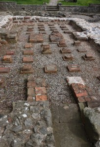
The foundations of the bath-house preserve the main features of a very small but classic Roman bath house, the plan of which is clearly visible on the ground. It measures c.11.7m x 4.5m (c.38 x c.15ft).  What you can see today was the under-floor part of the bath-house.  Over the top of most of these features, except for the D-shaped plunge pool, would have been a tiled floor.  The bath-house was built in two phases.

The bath-house in AD 120

Antefixes from the Roman bath house at Prestatyn. Source: Newstead 1937 (National Library of Wales)
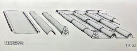
The walls of the building consisted of three courses of ashlar (dressed stone, to present an attractive appearance) filled with rubble and mortar to create the thick walls visible today.  The rubble within the outer walls was locally sourced, probably picked out of glacial soils near the site.   Of the exterior ashlar, Newstead found purple micaceous sandstone blocks in situ along the base of the northern wall of the bath house, the nearest source of which was around 6 miles away (and can be seen in use today at Rhuddlan Castle and St Asaph’s Cathedral).  Broken roof tiles were also used in the construction.  Inner walls might have been plastered and could have been decorated.  The roof was tiled, and provided with decorative triangular antefixes showed LEG XX V V legend as well as the legion’s wild boar emblem, which like the tiles were provided with stamps identifying them as work of the 20th Legion.  The 20th Legion’s tile-works at Holt near Chester clearly provided the tiles and bricks required or the bath-house in AD 120, and it is possible that they assisted with the construction works, but there is no sign that this was a legionary base, or that the 20th Legion controlled whatever activities took place at the site.  Apart from the tiles and bricks, all of the stone used at the site was sourced within a few miles of the site.

Information board in the Grosvenor Museum, Chester, showing how antefixes were used


The first phase of the bath-house with the hot room and warm room in Period IIA. Source: Blockley 1989

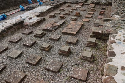
The plan to the left excludes the later cold room (frigidarium) with the D-Shaped plunge bath, showing the stone-built components of the bath-house in AD 120, when the bath house was built.  There is no sign of a stone-built cold room, which was was either missing, which would be very unusual, or was built of wood.  The two rectangular rooms, both of which sat over two hypocausts were both built in this first phase.  Hypocausts are artificial floors set on small pillars made of bricks and tiles (pilae) into which hot air, supplied by a furnace, is channelled.

In the tepidarium, Room B, Newstead found only two of the short hypocaust pillar bases, each bearing the stamp of the 20th Legion.  An internal doorway gave access to the Room C, the hot room or calidarium which was nearest to the furnace, where the remains of another fourteen pillars (pilae) survived.  The pillars were made of a c.28 x 28cm (11 x 11 inches) brick stamped with the 20th Legion’s name:  LEG XX V V (an abbreviation of Legio XX Valeria Victrix: 20th Legion, Valiant and Victorious). These were placed face down into the floor.  These was then topped with tiles c.19 by 19cm (7.5 x 7.5 inches) set into clay, none of which were stamped.  The hypocaust bricks and tiles were sourced from the specialist tile and brickworks at Holt on the Dee just south of Chester.

Tile bearing legionary stamp from Prestatyn. Source: Newstead 1937 (National Library of Wales)

Illustration of a 20th Legion stamp on one of the bath house tiles. Source: Roman Inscriptions of Britain (RIB-2463_29_xiv)

Praefurnium leading into the calidarium and the tepidarium beyond.

The technical challenge for the builders came in the heating process, which required a furnace to provide the required heat to the two rooms. The remains of the furnace were found by Newstead, built into the centre of west end of the building and projecting 1.4m (4ft 6inches) beyond it, providing heat via a channel known as a praefurnium.  Its floor was originally flagged with large blocks of purple sandstone. You can still stand in the praefurnium, shown left, to look into the hot room (caldarium, room C) and the warm room (tepidarium, room B) room beyond.  Ducts or flues conveyed heat from Room C to Room B.

Like feeding a steam engine, this furnace would have required a considerable amount of fuel to keep the heat supplied, and this would have required manpower both to collect the right sort of wood and to feed it into the furnace.  There would have been storage nearby to dry and store wood.

The video below is a 3-D animation of how the hypocaust at Brading Villa on the Isle of Wight functioned, which gives a good idea how the smaller example at Prestatyn worked too:

Also see the excellent video at the end of the past where the Roman hypocaust at the bath house at Bath are described.

Beyond the bath-house, to its east, was a stone-lined well, and a drain that was also partially stone-lined.  The well was 1.6m deep and 1.1m sq at its base, flaring to 2.5m wide at its top.  It was probably used to supply the bath-house and the two nearby buildings R4 and R5, both of which were copper-alloy workshops dating to IIA.

AD 150 – the extension of the bath-house

The cold room (left) and D-shaped plunge room, right.

The Bath house as it was found when Newstead excavated it. Rooms B and C were included in the original building of AD 120; Room A, the D-shaped plunge-pool, and the masonry drain under the cold-room floor and a drain out of the plunge-pool were added in AD 150.  Source: Newstead 1937 (National Library of Wales)

As already mentioned above, there is no sign that a cold room was included in the first phase of the bath house.  It may have been built in timber, now lost, or it may not have been built at all. Perhaps given the climate, a rectangular cold room and accompanying apse-shaped cold plunge pool, Room A, were not considered necessary, although this is not true for other bath-houses in Britain.  The stone-built cold room was only built 30 years after the original construction of the bath house, measuring 32m by 4m (104 x 13ft).  A new entrance was presumably provided in the cold room, with an internal doorway into the warm room.

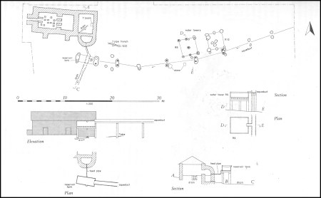
Plan and hypothetical elevations of bath-house water supply. Source: Blockley 1989, fig.28 p.51. Click image to enlarge.

The accompanying D-shaped plunge pool was lined with a 12cm (c.4.5ins) thick layer of opus signinum (a type of waterproof pink mortar) on a base of limestone and mudstone fragments set in to clay.  It was around 1.4m (4.5ft) deep.  Blockley describes the water supply to this plunge-pool as the “most completely recovered layout known in Britain,” which included a stone and timber drainage channel, an aqueduct fed by a natural spring, and possibly water tanks.

The diagonal drainage channel crosses the cold room, originally under the floor of the cold room. Blockley believes that this was probably connected to an internal basin.  A second drain leads from the apex of the D-shape as shown on the diagram above, the first 1.6m (c.5ft) within the bath-house had a floor of 40cm sq (c.15.5cm) bricks and was lined with limestone. South of the masonry section it was made of wood, and extended for 14m (c.46ft).  The wooden uprights survive along one section, probably used to hold planks in place along the sides of the drain, which was 25cm deep and 70cm wide with stakes at c.20cm (c.8ins) intervals.

The line of the aqueduct, found in the 1980s excavations, was indicated by a row of parallel postholes.  It ran from the east of the bath-house into the plunge-room, running over the top of the external drain.  Nine of the postholes had timbers of alder-wood in situ, up to 65cm long and 35cm (c.13.5ins) diameter.  The distances between timbers varies along the route, between 1m (c.3ft) and 1.5m (c.5ft).  A water tank may have been sited part way along.  It is thought that a spring further up the slope would have taken the aqueduct over a gradient of some 3m.

Using the Roman bath-house

A section of one of the information boards at the site showing the hot room, far left next to the furnace, the warm room in the middle and the later cold room and plunge pool. Click to expand and see the text clearly.

Had you been lucky enough to be a Roman official with access to a local bath house, bathing followed a sequence of steps that was imported from the core of the Roman Empire.  Movement was through a sequence of warming and cooling experiences.

Roman bathing followed a specific process. Bathers would get changed, and in bigger bath-houses there was a room put aside for this.  They would then progress from the unheated cold room (frigidarium) to the warm room (tepidarium) to acclimatize and then to the hot room (caldarium) before heading back to the cold room to cool down and take a cold dip in the plunge-pool.  All well and good in southern Italy during a balmy Mediterranean summer, and perhaps even in a good Welsh summer, but that cold pool really didn’t look that appealing to me on a chilly day in April!  A bathhouse was often accompanied by an outside, walled exercise area, but there is no indication that the Prestatyn bathhouse offered such a facility.

The Melyd Avenue complex of buildings

1930s survey of the masonry buildings at the site, showing the stone buildings including the bath house (B3 near the bottom of the image) and the trial cuts cut across the site. Source: Newstead 1937 (National Library of Wales)

The bath house was part of a bigger complex of buildings, only some of which have survived.  The site was discovered and informally investigated in 1933 by Mr F. Gilbert Smith, who noted objects and carried out surveys.  It was thought that it might have been a component of a Roman fort.  It was excavated between 1934 and 1937 by Professor Robert Newstead, who found both the bath house (his Building 3) and two other stone-built buildings (Buildings 1 and 2).  He also investigated a section of “paved causeway” found by Smith, and made 9 “cuts” (investigative trenches) at other parts of the site.  The bath house has been described above.  Building 1 consisted of three rooms in a line, with what had once had a tiled floor at one end, and measured c.19 x c.7m (62ft 6ins by 23ft). It produced a coin of Vespasian dating to c. AD 71, as well as pieces of a Samian ware platter also dating to the late 1st century. Samian ware (terra Sigillata) is a bright, glossy red high-status pottery often highly decorated in relief, which is often stamped with the manufacturer’s mark, and is very useful for dating (see image further down the page, and the excellent video at the end of the post by Guy de la Bédoyère). Building 2 was less clearly defined and far less informative, at least c.11m long (36ft), producing a single undated piece of amphora, and had been damaged by fire.

Samian pottery found at the Prestatyn site. Source: Newstead 1938

The cut through the section of “paved causeway” identified by Smith and shown on the above plan revealed that it was made of flat sandstone slabs over large pine logs on top of “a  mess of brushwood in a peaty matrix.”  Within these layers there were Roman potsherds and pieces of window glass as well as animal bones.  The other cuts revealed no features but the one in front of building 3 produced a piece of millefiori glass, 7 pieces of window glass, some fragments of a glass flask and a small black counter as well as some samian ware.  In 1938 further excavations produced no more buildings, and consisted mainly of taking sample cuts through the site, and these produced Roman levels that contained fragments of Roman objects.  All of the data from the site over the years of excavation placed it within the later 1st to the later 2nd centuries AD. As well as tiles and antefixes stamped with 20th Legion stamps, diagnostic finds included a Vespasian coin, some distinctive pieces of samian,  other dateable types of pottery and fragments of decorative and glass as well as some fittings for horses and some jewellery.

The 1972-73 rescue excavations followed another building development in nearby Prestatyn Meadows, during which Roman materials were found, including a column base and tiles stamped with  LEG XX VV. Excavations could not take place at the precise location of the discovery due to building regulations, and were therefore carried out a little to the south, with three trial trenches opened to sample the area.  No structural remains were found, but there were plenty of objects dating to the late 1st and 2nd centuries AD, consisting of building fragments and domestic rubbish including samian, coarse ware, window glass, flint, animal bones and coal.

Period plans showing the location of major features. Source: Blockley 1989, fig.6 p.12

The 1984-5 excavations, undertaken and published by Kevin Blockley in 1989 on behalf of the Clwyd and Powys Archaeological Trust (CPAT), considerably expanded the view of what was going on at the site.  Excavations took place over two seasons, or 47 weeks, and uncovered 1544 sq m (c.5065) sq ft).  As well as both pre-Roman and post-Roman discoveries, he found eleven timber-built buildings over two phases of Roman occupation, most of them with both postholes and stakeholes, indicating a probable timber frame with wattle-and-daub wall construction.  Over 2000 small-finds were excavated.  Blockley and his team were also responsible for the discovery of the well and the water supply to the new cold room and plunge pool added in c.AD 150, described above.  Most importantly, the excavations were able to make more sense of the chronology of the site, making use primarily of pottery types to derive date-ranges for different buildings and phases.

Sequence diagram for Period II, and location plan. Source: Blockley 1989, fig 31 p.54. Click image to enlarge.

Blockley concludes that the earliest phase of the site was building R1, which, judging by Flavian date pottery and Vespasianic coins, both of which showed significant use-wear, suggest a start date somewhere in the AD 70s.  The bronze-smith workshops were first established in around AD 90-100 with buildings R3 and R4, and the site continued to develop until around AD 160, when it was abandoned.  The bath-house, established in AD 120, was therefore built when the site was already some 50 years old.

The data in the timber-built buildings included features (like postholes, wall trenches, hearths and floors) and finds (industrial tools, industrial waste, and manufactured objects like horse-ware fittings, whetstones, querns, millstones, spindle whorls, pestles and mortars, brooches and finger rings, tableware glass, window glass, both fine and coarse pottery, ceramic crucibles and moulds, items made of bone, leather, wood and clay, and bricks and tiles).  Pulling all the data from all of the timber buildings together, Blockley found that a picture of a copper-alloy works emerged, an industrial site that was producing goods that were probably purchased both locally and sent further afield, making use of the Roman communication network.

Brooches of copper alloy of the Colchester type. Source: Blockley 1989, fig 36 p.89

The metalwork, including some lead (including weights and pot rivets) and heavily corroded iron, was dominated by copper-alloy, a form of bronze.  This was used to make brooches, studs, plates, simple finger rings, pins, needles and shield-bindings.  Of particular interest are the enamelled brooches, with coloured enamel inlays in different patterns, of which a number of complete or near-complete examples were found.  These include Colchester, Headstud, trumpet, plate and penannular types, all popular fashion items in late 1st and 2nd century Britain, and some unclassified types.  Only one of the finger-rings stood out, and this was a copy, in tin, of a 2nd century Roman type of silver ring using yellow glass in place of a precious or semi-precious stone.

The glass includes 600 fragments, 377 of which were table- and kitchen-ware (the bulk of which were bottles) and 159 from window glass.  It all falls within the time-range of the first half of the 1st century AD to the end of the 2nd century.  Some of the table-ware was brightly coloured and highly prestigious, but most of it was blue-green.  The window glass is thought to have come mainly from the bath-house, and was notably smooth and of very high quality.

The pottery assemblage, consisting of broken pieces, included both fine wares and coarse wares.  It ncluded items made of local raw materials, making up 44% of the assemblage, and imports.  The imports included black-burnished ware from Dorset (10%), samian (14%) and amphorae from Spain and Italy (19%).  A small number of white-ware flagons from Mancetter were also found (1%).  Some were manufactured from the Holt kilns, near Chester, and others were probably made on the Cheshire plains.

Spelt. Source: Wikipedia

Botanical and faunal remains give some indication of diet.  Although botanical remains tend to be fairly rare, the waterlogged conditions in the well preserved 13 samples of plant remains that were sent for analysis, and included carbonized grain, chaff and seeds.  The well was abandoned after Period IIA, so these survivors probably belong to IIB, contemporary with the second phase of the bath-house.  Of the grain remains, spelt was the dominant species, followed by emmer wheat and small amounts of barley and oats, probably all crop-processing waste.  Spelt is particularly resistant to cold, wind, diseases and pests, so would have been the most suitable crop for an exposed area without good quality soil.   Weeds found in the samples represent those that grow in amongst crops, and are well adapted to disturbed conditions.

Animal remains, some of which retained butchery marks, include sheep (the dominant species), cattle and pig remains.  Some fowl were kept and horse bones were found in small numbers.  Wild species include red and roe deer, goose, duck and hare.

Interpretation – what did these buildings represent?

Coarse pottery from the Prestatyn site. Source: Newstead 1938 (National Library of Wales)

Although this all suggested a well-built if fairly modest settlement, neither Newstead nor Blockley discovered any indications of a potential fort.  A ditch with a clay “rampart” was found, but this was later interpreted as an enclosure for the settlement.  However, the idea that there may have been a fort at Prestatyn continued to linger, as this could have been a civilian settlement on the outside of a fort.  In 1973 Roman building rubble was found c. 30 to 40m south of the bath-house, and judged to date to not later than c. AD 150.  This rubble included a column base, some 20th Legion roof tiles, and fragments of building stones, pottery, window glass, fine and coarse pottery and flint, all dating to the 1st and 2nd centuries AD.  When planning permission was granted for the housing estate, it was excavated by archaeologists in the 1980s, published in 1989, discussed below, producing numerous timber buildings of 1st-2nd century Roman date.  Geophysical survey in the grounds of Ysgol y Llys in the mid-1980s and further evaluations in 2001 and 2003 failed to provide any Roman features or material.  Overall, the idea that the bath house was associated with a fort has now been rejected.

Detail from one of the information boards, showing the relatve locations of the bath house and its associated buildings, the nearby lead mines and St Asaph, which may have been Roman Varis.

So what was the bath house doing in this particular location?  The buildings themselves and the objects found suggest that the site probably represents an industrial site with a Roman lead-mining operation and harbour, which attracted Romano-British metallurgists who set up workshops nearby.  There was certainly a lead ore mining operating dating to the Roman period in nearby Meliden, and this seems like a good match for the location the site, sitting between the mines and the sea.  It is not the only lead-mining operation in northeast Wales. The best known source of lead locally in the Roman period was Halkyn Mountain, which had rich veins of lead ore (galena).  Another site exploited by Roman miners was in the Pentre-Oakenholt area of Flint, accompanied by a number of masonry buildings, and another was found at Pentre Farm, where timber structures and 20th Legion stamped tiles were found.

David Mason has described the Prestatyn site as “most likely a transhipment centre if not the actual focus of ore-smelting.”  He believes that one of the ingots of lead found in Chester, dated to AD 74, probably originated in Prestatyn (see image below).  It was marked with the word “DECEANGL,” meaning “mined in the land of the Deceangli tribe,” in whose territory it was found.  According to Roman records, at the time of the Roman conquest, most of Britain was divided into tribal areas, and the Deceangli were based in northeast Wales, giving the area a geographical as well as a tribal identity.  The ingot (or pig) was discovered in 1886 in the remains of what is thought to have been a Roman timber quayside on the Dee in Chester.  This quayside location for the ingot, together with the 20 ingots of lead found in the river at Runcorn, thought to have been lost in a shipwreck, underline the importance of moving lead by boat.

Lead ingot from a river jetty site at the edge of Chester racecourse dating to 74AD. Source: David Mason’s “Roman Chester. The City of the Eagles,” p.45

Three lead pigs (ingots) in the Grosvenor Museum, Chester, including the example shown above

In fact, given the sheer quantities that David Mason estimates would have been needed for the building of the fort at Deva (Chester), it is difficult to imagine the significant amounts being moved any other way: 39 tons or 50 wagon-loads for water pipes, and 34 tons or 43 wagon-loads for reservoir linings.

Roman lead pipes in the Grosvenor Museum, Chester

Lead stamp used to mark bread. The abbreviated inscription reads “Made by Victor of the Century of Claudius Augustus”

The Coflein report suggests that “a vicus-like settlement associated with a harbour installation designed for the shipment of lead and silver from nearby the mines, though its precise nature is unclear.”  A vicus was a small settlement (plural vici), usually rural, that springs up on the edges of a centre of Roman activity such as a fort or mining or quarrying operation in order to sell goods and services.  It has been suggested that some of those connected with larger military forts were established intentionally, but at smaller military and industrial sites there may have been a more spontaneous development of such vici.

The mixture of Romano-British timber buildings and more official stone-built structures argues for a pragmatic working relationship between the Roman military, the Roman industrial team operating at Prestatyn and local metallurgists, each benefiting from the resources, skills and knowledge of the other, as well as the potentially extensive through-traffic – although whether a British copper-alloy worker ever had the opportunity to test out the joys of the bath-house is an other matter!

A Roman Road?

Information board at the site showing linkages between different sites in the Roman period. Click image to expand to read clearly.

Most of these proposals would make sense if the bath house and the related structures that must have accompanied it were on a road that connected into the road network; or that it was associated with a port, or both.  The Antonine Itinerary lists a route in north Wales as Iter IX, which ran between the legionary fortresses at Chester (Roman Deva) and Caernarfon (Roman Segontium) at the crossing to Anglesey.  This bypassed the north coast in favour of a more direct route, which still, however, had to skirt the Clwydian Range, nearing the coast at the northern end of the range, which would not have been too far from Prestatyn .  As the CPAT report puts it:

It is assumed that a major Roman road ran the length The Vale of Clwyd, linking military sites at Caer Gai near Bala and an assumed fort in the Corwen area with sites in the neighbourhood of Ruthin and St Asaph. The course of this road and its relationship with Roman settlements and possible military activity in the vale will no doubt be discovered in the future.

The Roman fort of Canovium at Caerhun with St Mary’s Church in one corner. Copyright Mark Walters, Skywest Surveys, CC BY-NC-DD 4.0. Source: Vici.org

The route is presumed to have proceeded to the fort at Caerhun (Roman Canovium) in the Vale of Clwyd before heading towards Segontium and Anglesey.  A bath house with a hypocaust was found in the Canovium fort, which was built in c.75 AD and destroyed in c.200, with tiles similarly stamped with Legio XX markings. The Antonine Itinerary’s description of Iter IX mentions a Roman way station named Varis. Although its precise location is unknown, and there were suggestions that this might have been located at Prestatyn, the most likely candidate at the moment is thought to be St Asaph. It is possible that a branch road could have connected a settlement at Prestatyn to this route, possibly at St Asaph, particularly if it was being used as a coastal port.  Looking at a map, Rhyl might seem a better choice for a port, but there may have been political as well as economic reasons why Prestatyn could have been more suitable.

A Roman milestone was found at Gwaenysgor in 1956, dated to AD 231-5.  The nearest known Roman road was 6km away, so it was either brought from there or an as-yet undiscovered off-shoot of that road.

The site and its objects in the 20th and 21st Centuries

The bath-house site

Although the site was opened up for excavation in 1937 and 1938, it was covered over afterwards to protect it.  When planning permission was granted for the building of the housing estate, which began in the 1980s, archaeologists were allowed in to excavate, after which the site was left uncovered and preserved for visits by the general public.

Screen grab of part of Steve Howe’s Chester Walls page showing what Melyd Avenue looked like on one of his visits, as well as one of the stamped tiles in situ. Source: A Virtual Stroll Around the Walls of Chester website . Click to expand.

The modern story of the Prestatyn Roman baths as a visitor attraction is described by Steve Howe on his A Virtual Walk Around The Walls website here.  Steve Howe visited in 1998, when the hypocaust was in good condition, preserving tiles stamped with the name and symbol of the 20th Legion.  In subsequent visits in 2001 and 2008, Steve Howe talks about the the deterioration of the site, the absence of the stamped tiles and the general state of degradation.  Writing in 2022, in County Voice (a Denbighshire County Council newsletter), Claudia Smith outlined a series of works being proposed in order to repair the site and to improve its public appeal.

At the end of the 1984-5 report, published in 1989, Blockley suggested that looking for the postulated harbour would be a logical follow-up project, in the Fforddisa area of Prestatyn, but this has not yet taken place.

In 2018 the Daily Post reported that an area of land earmarked for a housing development near Dyserth (to the south of Prestatyn) was under assessment by the Clwyd-Powys Archaeological Trust with a view to excavating it to attempt to find the elusive section of Roman road that it is thought must have connected Prestatyn with the wider world, but I have not yet tracked down any follow-up to this story.

Artefacts

Professor Newstead describes, in his 1937 publication, how some objects remained in the private collection of Mr Smith, the discoverer of the site, and how those that Newstead himself had excavated were removed to the National Museum of Wales in Cardiff.  The Roman Inscriptions of Britain website mentions that many of the inscribed objects from Prestatyn were in the Prestatyn Museum, but also notes that this appears to have closed down.  There is no note of where either Mr Smith’s collection or the Prestatyn Museum’s objects (perhaps one and the same) may have ended up.  I cannot find a record in Kevin Blockley’s account of the 1984-84 excavations of where the artefacts from that excavation were eventually sent.

Final Comments

Although the bath-house, built in around AD 120, was small, by AD 150 it contained the three main components required for a bath-house: the hot room, warm room and cold room with plunge pool.  This required two technical elements – a means of heating the two heated rooms (furnace, flues and hypocausts) and a means of channelling cold water to and from the cold room (aqueduct and drains, and possibly water tanks).  A store for wood would have been required adjacent to the bath-house.  The bath-house was the leisure-centre for a settlement dominated by industrial workshops, notably for the manufacture of objects made of copper-alloy (bronze).

The site is a bit like a glacial erratic – something unexpected left during a substantial invasion and after a substantial retreat.  There is not a great deal of Rome preserved above the ground in northeast Wales, and that gives the Prestatyn Bath House all the more kudos. As more sites are discovered and more stretches of road revealed, the picture should become clearer.  In spite of neglect in the past, during which some of the stamp-marked tiles were apparently removed, it is a great little site to visit, for which details are provided below.

Visiting

As mentioned above, this is right in the middle of a small housing estate, a cul-de-sac.  It is just off the A547 (Meliden Road) to Prestatyn on Melyd Avenue.  Its What3Words location is ///unfocused.detective.jetting. There are two car parking spaces at the site, and a limited amount of on-road parking, but this is not a busy destination.  It was nice that we were not the only people there when we arrived, and I am sure that there are occasional school trips to a local heritage celebrity, but it was a quiet visit whilst we were there.

The two information boards at the site were helpful, and each of them had a QR code.  Very sadly it comes up with a “404 Page Not Found” message.  Always a disappointment when this happens and a good idea to provide additional information is allowed to lapse.

The approach pathway to the bath house ends in three steps.

Always thinking about people with unwilling legs, I would give this a thumbs-up based on my Dad’s experiences (walking with a stick due to a dodgy leg, but okay for the three steps at the site if there was an arm to lean on).  There are no handrails accompanying the steps, and part of the circuit around the site was blocked by repair works.

If you are coming at it from Chester, and want a day trip, it is worth coming off the A55 at Junction 31 and taking the opportunity to visit Gop Cairn, Gop Cave (see details on the Coflein website – parking in Trelawnyd and reached via public footpath, and about which much more on a future post) and the stunning Dyserth waterfall as well, which is just a few seconds from the road (operating a 50p per person honesty payment system, with a small car park next door).  Take a raincoat or hat – the spray from the waterfall is considerable and we got quite a good soaking!

There seem to be plenty of places to stop for a coffee in the villages, and we had a very good lunch at the newly renovated The Crown public house in Trelawnyd after walking up to Gop cairn and cave.

Sources

Books and papers

The site under excavation by Newstead in the 1930s. Source: Newstead 1937 (National Library of Wales)

Arnold, Christopher J. and Jeffrey L. Davies, 2000.  Roman and Early Medieval Wales. Sutton Publishing

Blockley, Kevin. 1989. Prestatyn 1984-5. An Iron Age Farmstead and Romano-British Industrial Settlement in North Wales. BAR British Series 210

de la Bédoyère, Guy, 2001. The Buildings of Roman Britain. Tempus Publishing

de la Bédoyère, Guy, 1988. Samian Ware. Shire

Dark, Ken and Dark, Petra 1997. The Landscape of Roman Britain. Sutton Publishing

Mason, David J.P. 2001, 2007. Roman Chester. The City of the Eagles. Tempus Publishing

Newstead, Robert 1937. The Roman Station, Prestatyn. First Interim Report. Archaeologia Cambrensis vol.92), p.208-32

Newstead, Robert 1938. The Roman Station, Prestatyn. Second Interim Report.  Archaeologia Cambrensis vol.93), p.175-91.


Websites

Coflein
Prestatyn Roman Site
https://coflein.gov.uk/en/site/306722?term=prestatyn%20roman%20bath%20house

Clwyd and Powys Archaeological Trust (CPAT)
Historic Landscape Characterization. The Vale of Clwyd. Transport and Communications
https://www.cpat.org.uk/projects/longer/histland/clwyd/cltransp.htm

A Virtual Walk Around the Walls of Chester
The Roman Bath House near Prestatyn, North Wales by Steve Howe
Part 1, 1998
https://chesterwalls.info/baths.html
Part 2, 2001 and 2008
https://chesterwalls.info/baths2.html

County Voice, Denbighshire County Council
The Roman Baths: A Roman Mystery in Prestatyn? December 2022
https://countyvoice.denbighshire.gov.uk/english/county-voice-december-2022/countryside-services/the-roman-baths-a-roman-mystery-in-prestatyn

Roman Britain
Caerhun (Canovium) Roman Fort
https://www.roman-britain.co.uk/places/canovium/
St. Asaph (Varis) Roman Settlement. Possible Roman Fort and Probable Settlement
https://www.roman-britain.co.uk/places/st_asaph/
Ruthin Roman Fort
https://www.roman-britain.co.uk/places/ruthin/

The Roads in Roman Britain
Roman Roads in Cheshire > The Roman Road from Chester to North Wales
Margary Number 67a. By David Ratledge and Neil Buckley
https://www.romanroads.org/gazetteer/cheshire/M67a.htm

Deganwy History
Roman Roads in North-West Wales. A talk by David Hopewell (Gwynedd Archaeological Trust (GAT), October 17th 2019. Written up by Lucinda Smith.
https://www.deganwyhistory.co.uk/roman-roads-in-north-west-wales/

Roman Insciptions in Britain
RIB II.2404.31-2 lead ingot found in Dee at RooDee in 1886
https://romaninscriptionsofbritain.org/inscriptions/2404.31
Leg XX VV inscriptions found in Prestatyn both at the Baths and beyond

https://romaninscriptionsofbritain.org/inscriptions/search?qv=prestatyn&submit=

Wales Live (The Daily Post)
Archaeological dig could unearth Roman road on site earmarked for new homes. October 16th 2018. By Gareth Hughes
https://www.dailypost.co.uk/news/north-wales-news/archaeological-dig-could-unearth-roman-15285372

Vindolanda Charitable trust
A closer look at Samian pottery
https://www.vindolanda.com/blog/a-closer-look-at-samian-pottery

English Heritage
Baths and Bathing in Roman Britain
https://www.english-heritage.org.uk/learn/story-of-england/romans/roman-bathing/


Lecture: Rosemary’s Baby: Adventures and Insights from Contributing to the Corpus of Anglo-Saxon Stone Sculpture in England

Rosemary’s Baby: Adventures and Insights from Contributing to the Corpus of Anglo-Saxon Stone Sculpture in England

Paul Everson, Keele University

Tom Pickles, Chair of Chester Archaeological Society, introducing Paul Everson

On Saturday 4th May, in the last in-person Chester Archaeological Society lecture of the 2023/24 spring season in the Grosvenor Museum’s elegant lecture theatre, archaeologist and landscape historian Paul Everson introduced members and guests to the “Corpus of Anglo-Saxon Stone Sculpture (CASSS)”  project inaugurated in 1977 by Professor Dame Rosemary Cramp (https://corpus.awh.durham.ac.uk/).  With his long-time collaborator David Stocker, Mr Everson has published three volumes of the CASSS, and in this lecture explained how the decades-long project has not only provided us with a definitive catalogue of decorated stonework of the period but also stimulated new avenues of thought.

Professor Dame Rosemary Cramp’s name is synonymous with Early Medieval sculpture, combining her expertise in Old and Middle English with archaeological research, beginning her own excavations at Monkwearmouth in 1957.  Having identified an opportunity to create a corpus of early stone sculpture after working on examples in Durham Cathedral and the Wearmouth and Jarrow monastic sites, she developed a standardized format for the publication of the CASSS, and a “grammar” of Anglo-Saxon ornament (also used for knitting!). This enables each volume of the corpus to be used in the same way and, where required, directly compared, making the series invaluable as a cohesive research tool.  The first volume to be published was County Durham and Northumberland in 1984, and the last two, currently being compiled, are volumes 15, Leicester, Notrh Rutland and Soke Peterborough and volume 16, Norfolk and Suffolk.

Some examples of the types of Anglo-Saxon sculpture included in the Corpus (slide from Paul Everson’s presentation)

The corpus of Anglo-Saxon carvings, dating from the 7th to the 11th centuries and much of it previously unpublished, includes crosses, grave markers and grave covers, architectural detailing and inscriptions, both in original locations and in relocated positions. The compilation of the Corpus required the establishment of procedures for locating and recording both known and previously unidentified carvings. A mixture of archaeological, field survey and historical approaches are employed.  All churches in a Corpus volume area are inspected, inside and out.  Sketches, photographs, measurements and notes ensure that full details were recorded.  Lost items have been rediscovered by tracing records in publications produced by antiquarian and early scholars.  Antiquarian and early scholarship are always described and credited in the first chapter of each volume, reflecting their value.

As with most archaeological data, Anglo-Saxon sculptures often exist only in fragments and this requires virtual reconstruction work so that these too can be understood as whole pieces and included in the corpus.  It was interesting to note that, like Roman tombstones, the ornament was picked out in bright paints, exemplified by a replica from Neston which has been rendered in full colour, shown on the above slide.

Bringing to together substantial data across each area has led to an exploration distribution patterns, with some specific types distributed widely across a county and others being more localized, leading to a search for explanations  An example is Raunds Furnells where a small cluster of 10th century stone monuments may help to explain similar finds in east England, perhaps representing the founding families of churches, which in turn may represent the first stages of the development of the parochial system.  “Exceptional collections” also occur, where large numbers of sculptural stones are found in a particular location, and it has been found that these tend to be near river sites where markets were held, and where merchant communities with disposable incomes concentrated, such as Chester where an impressive collection is retained at St John’s Church, and at Neston on the Wirral.

The Hedda Stone, Peterborough Abbey

A surprising finding was that there may have been very little pre-Viking quarrying of new stone.  Instead, earlier stone masonry in church architecture and graves was often recycled and has become a much-debated topic.  Some of these re-uses are pragmatic and practical, making use of usefully shaped pieces.  The re-use of Roman masonry could explain, for example, some puzzling holes in the famous early Medieval Hedda Stone at Peterborough Cathedral.  Another form of recycling is described as “iconic,” where earlier scenes are appropriated and re-positioned in a new cultural context.  Interpretation of specific instances of recycling differ, and the resulting debates, although usually amicable, may be very animated! Discourse provided by differing perspectives, specialisms and sub-disciplines and by a new generation of researchers ensure that research into Anglo-Saxon sculpture continues to be a lively field.

At the other end of the chronological scale, studies of post-Conquest sculpture have helped to elucidate the continuity of earlier medieval traditions, and this too is an important research vector for understanding the period when Saxon and Norman interests vied for supremacy.

Making use of database technologies, an important leg of future work will include the Arts and Humanities Research Council (AHRC)-funded “Worked in Stone” project which will re-digitize all the volumes to make them into a fully searchable database, an important new initiative that will be hosted by the Archaeological Data Service (ADS) and will be free to access.).

The challenges of interpreting different syncretic and iconic schemes. (slide from Paul Everson’s presentation)

An enthusiastic round of applause marked the end of the lecture.  There was the opportunity for questions, and the audience took full advantage.  The topic of recycled Roman stonework lead to some discussion about how identity and meaning may have been syncretized or replaced.  Another question concerned how future discoveries might be incorporated into the corpus, and although nothing formal yet exists, the topic is obviously on the minds of those looking to the future of this research area.  At the end of the questions the audience again applauded loudly in appreciation.

By the end of the lecture, it had become clear that the loss of Dame Rosemary last year at the age of 93, and the publication of the final two volumes of CASSS will not draw any sort of line under the research into Anglo-Saxon sculpture.  The Corpus continues to be provide an invaluable resource.  The digitization of the corpus will make it readily available to support a new generation of researchers as they develop new ideas and perspectives and explore new directions. It is clear that in spite of her passing away last year, this project remains very much “Rosemary’s Baby.”

The first twelve volumes of the CASSS are available online at https://corpus.awh.durham.ac.uk/.  For Anglo-Saxon stone sculpture in Cheshire see volume IX. For a paper produced as an offshoot of the corpus work, see the study of the social background of the St John’s (Chester) crosses in the Members Area of the CAS website (https://chesterarchaeolsoc.org.uk/members-area/): P Everson & D Stocker. Transactions on the Dee: the ‘exceptional’ collection of early sculpture from St John’s, Chester
In: Cambridge, E & Hawkes, J eds. Crossing boundaries: interdisciplinary approaches to the art, material culture, language and literature of the early medieval world. Essays presented to Professor Emeritus Richard N. Bailey, OBE, in honour of his eightieth birthday. Oxford: Oxbow Books, 2017, 160–78.

Finally, the international ‘Worked in Stone: Early Medieval Sculpture in its International Context’ conference  takes place next year in Durham (https://corpus.awh.durham.ac.uk/wis.php).

Many thanks to Paul Everson for such am engaging and enlightening lecture.

Paul Everson in the Grosvenor Museum lecture theatre

Field-walking and prehistory in Churton fields in 2006

Fieldwalking in Churton, supervised by Phllip Miles in 2006.

With many thanks to my friend Helen, who is shown second from the left in the very blurred image at the top of this 2006 article, for sending me a copy of this.  Phillip Miles , for the Chester Archaeological Society, supervised a field-walking expedition to two of the fields behind Churton, just north of Farndon, and made some very significant discoveries.

Aerial survey and metal detecting had already identified some interesting features in the fields above and to the east of the River Dee (see photos below), thought to belong to Neolithic, Bronze Age and Romano-British periods.  The fieldwork, carried out with permission from the landowner, confirmed that the land has a lot more prehistoric data to offer.

Although the Late Neolithic and Early Bronze Age in northeast Wales and the borders along the Dee are most noticeably represented in the landscape by burial and ceremonial monuments, the narrative of everyday working life in prehistory is embedded in the surface scatters of stone tools that remain in fields and on hillsides. These were the tools that people used every day in their subsistence strategies, and are the intimate toolkits of their livelihoods.

The analysis of the findings was underway at the time of the article, so no findings were reported, and it will be interesting to follow up on this to see what was concluded (if the analysis was published).  It was also suggested in the article that there could be scope for future work in Churton, although it is unclear at the moment if this took place.

Possible Neolithic enclosure in the fields behind Churton

Possible barrow cemetery near Knowl Plantation to the west of Churton


April’s ‘Chester Archaeological Society’ visit to St Collen’s Church in Llangollen

The Chester Archaeological Society 2024 season of excursions started excellently today with the CAS visit to the Church of St Collen, who gave his name to Llangollen. It is the only church in Wales to have taken the saint’s name. Like most Medieval churches in Wales, St Collen’s has undergone considerable alterations, including an 18thcentury tower and a 19th century chancel, vestry and south nave, but there are some very fine 13th century features to be seen, in the Perpendicular Gothic style, including an impressive shrine canopy and mason’s marks. There are also intriguing signs that a Lady Chapel was once incorporated into north aisle. The most remarkable feature of the church is a really superb hammerbeam roof bedecked with ornamental sculptures, both religious and secular, from the early 16th century.

Today, to ensure the survival of the church as a living and breathing community asset, it is undergoing extensive but very sympathetic re-forming.  Suzanne Evans is the Project Manager of this massive task, and was our superb guide today. Suzanne described how the reinvented church will be fully inclusive, not only of the existing congregation who are much-attached to the church, but of the wider community as well, taking into account the needs of those currently unable to make the most of what St Collen’s has to offer. At the same time, the exciting opportunity will be taken to investigate as much of the church’s architectural and funerary history as possible, adding to the community’s understanding of this important contributor to the town’s impressive ecclesiastical heritage.

Suzanne guided us around both the key features and recent discoveries, explaining all the steps to be taken in the upcoming weeks and years. As well as replacement glass doors and the opening up of the nave to enable the interior to be visible by passers-by, there will be new lighting, heating, kitchen and toilet facilities, as well as a large stage, which will all contribute to enhancing the value of the space and improving the visibility of the superb architecture. All archaeological and architectural discoveries will be professionally recorded and published.

After a very welcome cup of tea, there was a round of applause as we thanked both Suzanne for being our terrific guide and Pauline for making all the arrangements. It was great to meet some of the other CAS members, and to hear all the questions and observations. There was a lot of information sharing, which is exactly what one expects of CAS members. What a great start to the year’s excursions! Many thanks again Suzanne and Pauline.

The 13th century exterior


The River Dee in Llangollen today – noisy, fast and beautiful!

I was in Llangollen today with the Chester Archaeological Society to visit the Church of St Collen, which is undergoing a major project of reinvention.  More about that later.  For now, here’s a video of the River Dee as it churned its way ferociously through Llangollen today.  Truly impressive!  By the time I returned home, crossing the Dee at Farndon-Holt, it had lost some of its energy, but was still an impressive sight.


Archaeology of North Wales and Marches – Videos from the Darganfod-Discovery Conference 2021

Whilst looking for something else, I stumbled across the following page on the Cambrian Archaeological Association website, which has some impressive videos from the Darganfod-Discovery Conference 2021, some of which are relevant to North Wales and the Marches.
https://cambrians.org.uk/talks/darganfod-discovery-2021-talks/

Presentations from Darganfod-Discovery 2021 – a day dedicated to fascinating recent work on the archaeology of Wales and the Marches, held in conjunction with Cardiff University on 10th April 2021. This online conference is the first of a new series that showcases work supported by the Cambrian Archaeological Association Research Fund as well as providing an opportunity for early career academic and independent researchers to present research on Wales and the Marches.

Lectures on the above page include:

  • Prof Gary Lock of Kellogg College, Oxfor
    • ‘Moel y Gaer, Bodfari, a small hillfort in the Clwydians, Denbighshire’. (CAA Research Fund project)
  • Eirini Konstantinidi, PhD researcher at Cardiff University
    • ‘If the dead could talk: a taphonomic approach to Neolithic mortuary treatment in the caves of Wales’.
  • Adelle Bricking, PhD researcher at Cardiff University
    • ‘Life and death in Iron Age Wales: preliminary results from histological and stable isotope analysis from Dinorben and RAF St Athan’. (CAA Research Fund project)
  • Dr Rachel Swallow, Honorary Research Fellow at University of Liverpool
    • ‘A square peg in a round hole: new interpretations for the eleventh-century northern Anglo-Welsh border, as told by the misfit Dodleston Castle in Cheshire’.

There are other great lectures too, but those listed above are specific to north Wales and Cheshire.