Yesterday I went to find the section of the Roman road that runs from Chester, through Aldford, and down to the east of Churton. I have divided this post into two parts. The first part, below, looks at the background to Roman roads in Britain. Part 2 describes the walk itself.

The Cuppin Street excavation one lunchtime, 1986 or 87. My photo.
As mentioned in the introduction to this blog, I trained as an archaeologist and spent my summers in the 1980s digging up various parts of England and Wales. Although technically a prehistorian, my early excavation experience also included the Roman temple site at Caerwent (Venta Silurum in southeast Wales), the basilica at Silchester (Calleva Atrebatum in Hampshire) and three consecutive seasons with the Grosvenor Museum team on the multi-period Cuppin Street site in Chester (Deva). Whenever modern building work takes place in Chester, the city’s archaeologists are given time to undertake excavations. Before we started digging it up, under the capable direction of Dr Simon Ward, the site was an informal, roughly surfaced car park that was destined to become the Magistrates Courts, originally just outside the Roman town’s walls.
A collapsed road was one of many important features that made up a truly fascinating site. The metalled road had a central dip along its depth, which we set out to investigate. Black tar from a defunct Victorian gasworks oozed into a very deep trench, where a friend and I were excavating what lay beneath the road. A wood-lined drain beneath the road had slowly collapsed over time, becoming blocked with general waste, the middle of the well-made road had gently subsided into the void, creating a bizarre concave profile. Drains in Deva were often located under roads, and could be up to 5ft deep. The Cuppin Street example was one of several major and minor roads and lanes that punctured Deva from all directions. I’ve had something of an interest in Roman roads ever since.
Deva (later Deva Victrix) was at the far northwestern edge of the roman Road network Where England and Wales met at the point where the Dee emptied into its estuary. It was a strategically important Roman base with a large command area over much of the northwest and north Wales. The legionary fortress was established by at least AD79 in the territory of the Cornovii who were based at Wroxeter (Virconium Cornoviorum), although Rome’s presence in the Chester area predates the permanent fortress by two decades. There is no indication of violence, and it is possible that the Cornovii had already come to terms with the Roman invaders, perhaps as early as AD43 when Claudius entered into treaty relationships with a number of kings. Whatever Roman presence had been here previously, the fortress was established in AD79, having been started in around AD74-75, and was built by the Second “Adtiutrix” Legion. In AD86 the second legion was sent to the Danube and was replaced by the Twentieth “Valeria Victrix” Legion, which remained until the withdrawal of the Roman army from Britain in AD 410.

One of Julian Baum’s stunning impressions of Deva, showing the
beginning of Watling Street West (Margary 6a) and the Dee
crossing. Source: Julian Baum, Take27 Ltd.
When completed, the Deva fortress covered over 60 acres (24 hectares) on the standard playing-card plan (see site plan below), and eventually housed up to 6750 soldiers, servants and slaves, and was the headquarters of the local legion. It was a sizeable entity, 20% larger than both Caerleon (Isca) and York (Eboracum), which were both permanent legionary fortresses that were built at much the same time as Deva. It has been suggested that this size may have been needed to accommodate some unusually grand buildings under orders from an important official resident at the fortress, perhaps the provincial governor who, appointed by the emperor himself, would have required a more impressive portfolio of amenities than the usual fortress would have provided. A civilian entourage followed the military, including merchants, service providers and families of the soldiers (legionnaires were not permitted to marry until AD212, but this did not prevent them having partners and children). They were not permitted to live within the fortress so settlements (canabae legionis) grew up as suburbs immediately in the vicinity of the fortress. Also near to the fortress were the site’s cemeteries. Other small civil settlements growing up further afield at Heronbridge, a farming community, and the smaller Saltney. A tile and pottery works was established further down the Dee at Holt.

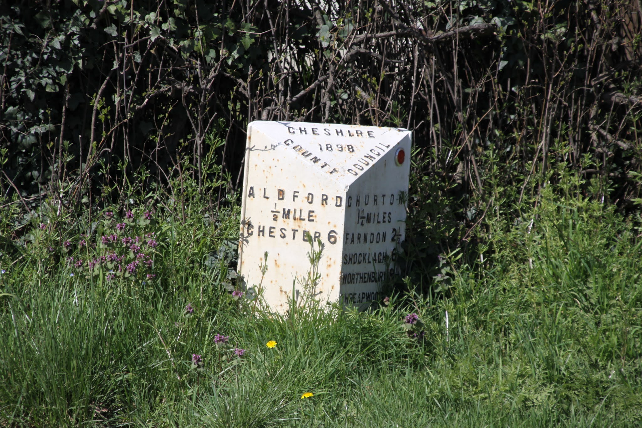
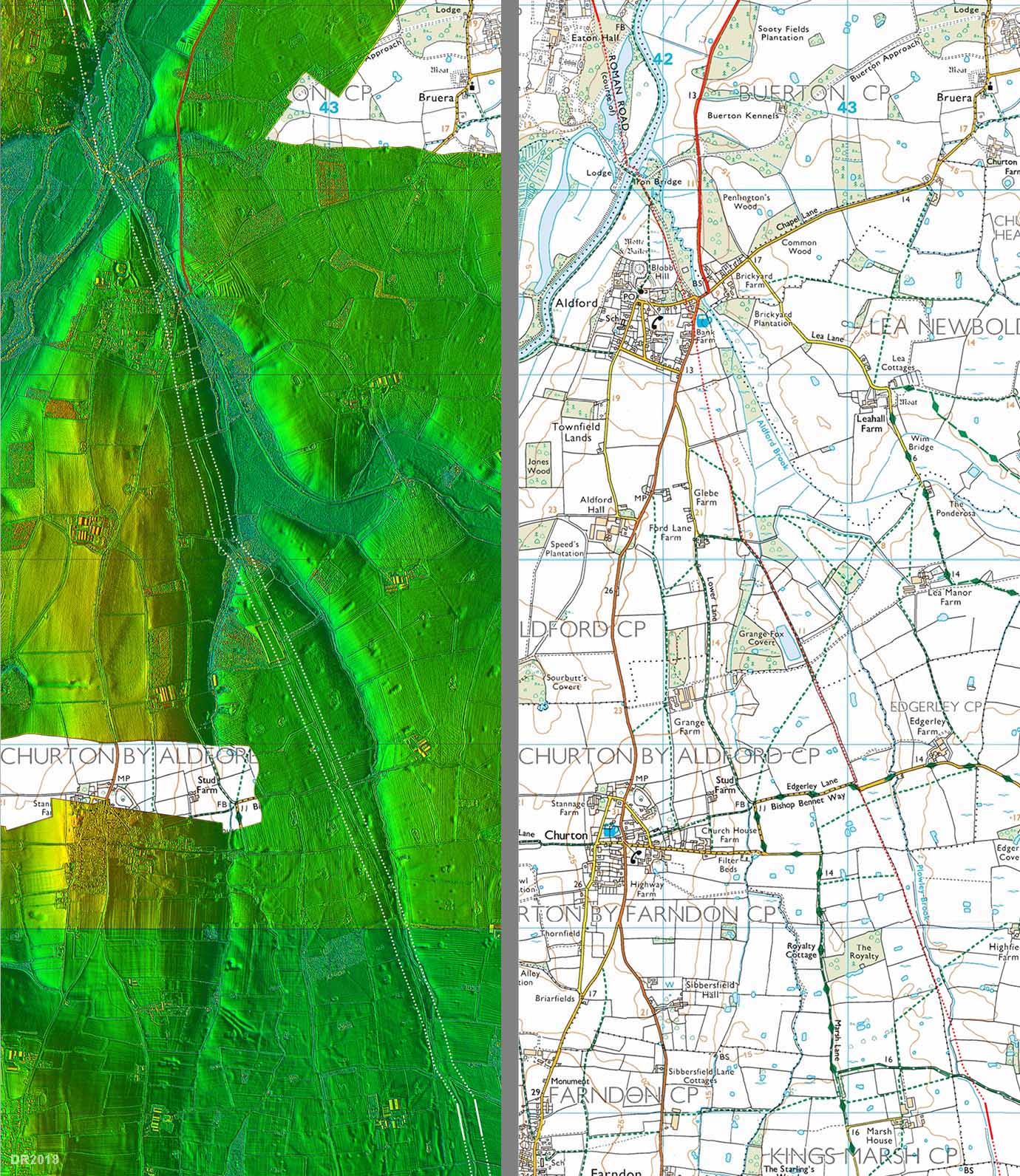
Roman roads of the Chester area. 6a and 6aa leave Chester and head south, meeting at Alford. 6a continues south, passing to the east of the Dee and the villages of Churton and Farndon. Map source: The excellent “Roads of Roman Britain” online gazetteer.
The fortress was in a good strategic position, convenient both for subjugating fractious groups in north Wales and for maintaining control over the northwest, where subjugation of the troublesome Brigantian tribe had become a priority. It was built on a rise in the land within a bend in the river Dee, meaning that it had natural defences on two sides, which contributed substantially to the security of the walled fort. The racecourse, on the Roodee, sits on the location of what was once a natural harbour, enabling a busy port to flourish on the Dee just beneath the fort. This was a natural extension of the road network, enabling the fort to be provisioned, with both soldiers and supplies being brought in from Europe, and for local commerce to develop along the coast. The Romans brought a wide selection of foods to Britain that we now think of as everyday, but were then luxury items, including apples, pears, cherries, grapes, asparagus, cabbages, carrots, onions, turnips, cucumbers, fennel and dill. High value perishables like these were much better transported by sea than road, which was both slower and could seriously jolt fragile produce. Other luxury items usually trusted to sea rather than road were high quality but delicate or costly objects like samian pottery, glass and vessels of wine. To link north and south, the river required the provision of a bridge, and this was erected where Lower Bridge Street crosses the Dee into Handbridge. In its place is now the Old Dee Bridge, dating to the 14th Century. The road went on to Whitchurch and Wroxeter, from where a number of destinations were possible. Today it is known as Watling Street West. Other roads out of Deva headed north, east and west, as shown on the map below.
The vast and complex road network was the glue that bound the impressive imperial infrastructure of forts, fortresses, fortlets, towns, inns, way-stations, camps and industrial centres. It is a remarkable cat’s-cradle of long straight stretches, most metalled or paved, others very rough, with some following much older trackways. Today many modern roads follow these original Roman routes, like Watling Street, along which the A5 now travels. Roman roads were planned out by teams of engineers and surveyors. There are no documents detailing how the task was achieved, but the first step was probably to establish the line of the road, which was planned as a more or less straight line, as the crow flies, from a to b (in this case Chester to Whitchurch). Just as today, the army had trained surveyors and engineers. A map would probably have been prepared, and the required line would have been staked out.
Although the local geology, geomorphology and soil structure determined the exact construction of roads, they followed a basic conceptual idea of how a road should be built. Roads were flanked by drainage ditches, which carried rainfall runoff and provided quarry material for a raised section along the road. In profile, the roads were were usually built up above the level of the surrounding landscape and were cambered, with a curved top and sloping edges to aid drainage. Many modern accounts describe four or more levels of construction, but Hugh Davies says that this belief, widespread but incorrect, was probably a misreading of the work of a famous Roman architect called Vitruvius who certainly describes for successive layers, but was actually referring to paved areas around prominent buildings rather than roads. In the case of roads, a standard arrangement was usually much simpler, consisting of two levels, although road construction methods differ from one place to another. The standard arrangement consisted of an agger (a built-up section of road between the two drainage ditches), a layer of rough metalling consisting of stones, cobbles, pebbles and smaller infill, and then a top layer of smaller stones and/or gravel. Some were then topped with paving stones, which helped to preserve them. The agger could be up to 1.2m (4ft) but was often raised only just above the level of the surrounding landscape. Like forts and temples, roads were not strictly standardized. Today some remarkable examples survive, but the greater majority have been destroyed or eroded. Re-use for modern roads and expansion of urban settlement have destroyed sections of roads, while weather damage and compaction over the centuries have flattened many of the surviving roads and broken up their surfaces.

Sasha Trubetskoy’s schematic map of Roman Britain, based on
Harry Beck’s London Underground map of 1933. Click image to see a bigger version. Source: Sasha Maps
Modern knowledge of this vast network, extending from the south coast into mid Scotland, has been built up by extensive detective work from the 18th Century onwards. Initial research into the British Roman road network was based on the “Antonine Itinerary,” written in c.AD 200, one of handful of surviving Latin documents that provide records names and other data that can help to located both and the routes of roads. The document is made up of a series of lists, and each list, or iter, provides details about the start and end point of each route, its total mileage (mille passus or m.p, meaning 1000 paces) and notes places distributed along the routes. The lists only cover about 25% of British roads, and are by no means complete, but they have been an invaluable research tool. Today, with dedicated work on foot, together with the use of remote sensing technologies from the air, each year new discoveries help to fill the obvious gaps and to reveal unsuspected stretches. One of the most important organizations contributing to this task of identifying sections of the road network is the terrific Roman Roads Research Association, which builds on work pioneered by Roman road expert Ivan D. Margary. Margary devised a numbering system to both identify and categorize Roman roads, publishing his comprehensive “Roman Roads in Britain” in 1955, which continues to be an invaluable reference. The Roman Roads Research website includes an invaluable online gazetteer, the Cheshire section of which has been assembled by David Ratledge and Neil Buckley, with many thanks for such a great resource. The outcome of all of this research is nicely captured on a cleverly conceived schematic map designed by cartographer Sasha Trubetskoy, using the London Underground of map of 1933 designed by Harry Beck as a template.
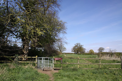
The Roman road that starts in Chester and passes to the east of Churton is Margary’s road number 6a, also known as Watling Street West. On the Cheshire West and Chester’s Public Map Viewer, the section of it that passes through Aldford and passes Churton is public footpath “Aldford FP8.” This is the subject of part 2.
Sources:
Books and journals:
Davies, H. 2008. Roman Roads of Britain. Shire Archaeology
Frere, S.S., Hassall, M.W.C. and Tomlin, R.S.O. 1988. Roman Britain in 1987. Britannia, Vol. 19 (1988), p.415-508
Jones, G.D.B. and Webster P.V. 1968. Mediolanum: Excavations at Whitchurch 1965–6. Archaeological Journal, 125:1, p.193-254
Lathan, F.A. 1981. Farndon. The History of a Cheshire Village. Local History Group
Margary, I. 1973 3rd edition). Roman Roads in Britain. John Baker 1973.
Mason, D.J.P. 2001, 2007. Roman Chester. City of the Eagles. Tempus
Mason, D.J.P. 2007. Chester AD 400-1066. From Roman Fortress to English Town. Tempus.
Peel, J.H.B. 1976. Along the Roman Roads of Britain. Macmillan
Shaw, M. and Clark, J. 2003a. Cheshire Historic Towns Survey. Aldford Archaeological Assessment. Environmental Planning, Cheshire County Council
Shaw, M. and Clark, J. 2003b. Cheshire Historic Towns Survey. Farndon Archaeological Assessment. Environmental Planning, Cheshire County Council
Ward, S. 2013. Chester. A History. The History Press
Website resources:
Cheshire West and Chester – Public Map Viewer
https://maps.cheshirewestandchester.gov.uk/cwac/webmapping
Roman Roads Research Association http://www.romanroads.org/
The Roads of Roman Britain
http://roadsofromanbritain.org/index.html
http://www.romanroads.org/gazetteer/cheshire/cheshire.html
A Web-enhanced version of Roman Roads in Britain by Thomas Codrington,
published by the Society for Promoting Christian Knowledge, London, 1903
https://tinyurl.com/75ujdd43

 Another walk along the Dee, this time to the north of Aldford, on another glorious sunny spring day.


