Category Archives: Industrial history

Day Trip: The Iron Bridge and the Ironbridge Gorge World Heritage Site

Introduction

The Iron Bridge is the star attraction of the Ironbridge area, the focal point of the UNESCO World Heritage Site (awarded in 1986), and managed since 1991 by the Severn Gorge Countryside Trust, which includes 52 sites, 60 historic structures, 230 hectares of woodland, 25 acres of wild flower meadow, 26kms of paths and 8 kms of bridleways.  This includes at least twelve museums and managed sites, some of which are open all year round, others only seasonally.  This makes the Ironbridge Gorge a splendid place for an extended visit as well as for day trips to selected destinations.

It can be easy to come away with a fragmented view of Ironbridge Gorge whilst driving between the bridge and the different museums and villages.  Once known collectively as Coalbrookdale, the immediate valley area is now divided into Ironbridge, Jackfield, Coalport and Coalbrookdale with outlying attractions in the surrounding area.  However, all areas are united by the underlying geology that was revealed by glacial action and became the source of raw materials for manufacturing in the area, both of ironworks that produced industrial scale projects like the bridge itself as well as decorative objects for home and office; and clay-based household objects such as tiles, and finer decorative china.

The first engineer and entrepreneur to exploit the full potential of the Ironbridge area’s geology for industry was Abraham Darby I who had a small furnace in the area and who in 1709 successfully experimented with carbonized coal, called coke, as fuel instead of charcoal that depended on less volumes of mature woodlands and required much less labour.  Abraham Darby I’s formula for iron was a ratio of 600kg coke to 600kg of ironstone and 250g limestone, all of which were available locally, and produced 250kg iron.  Efficiencies in the iron manufacturing industry were further improved with refinement of coke production and the introduction of steam-powered engines later in the 18th century.
==
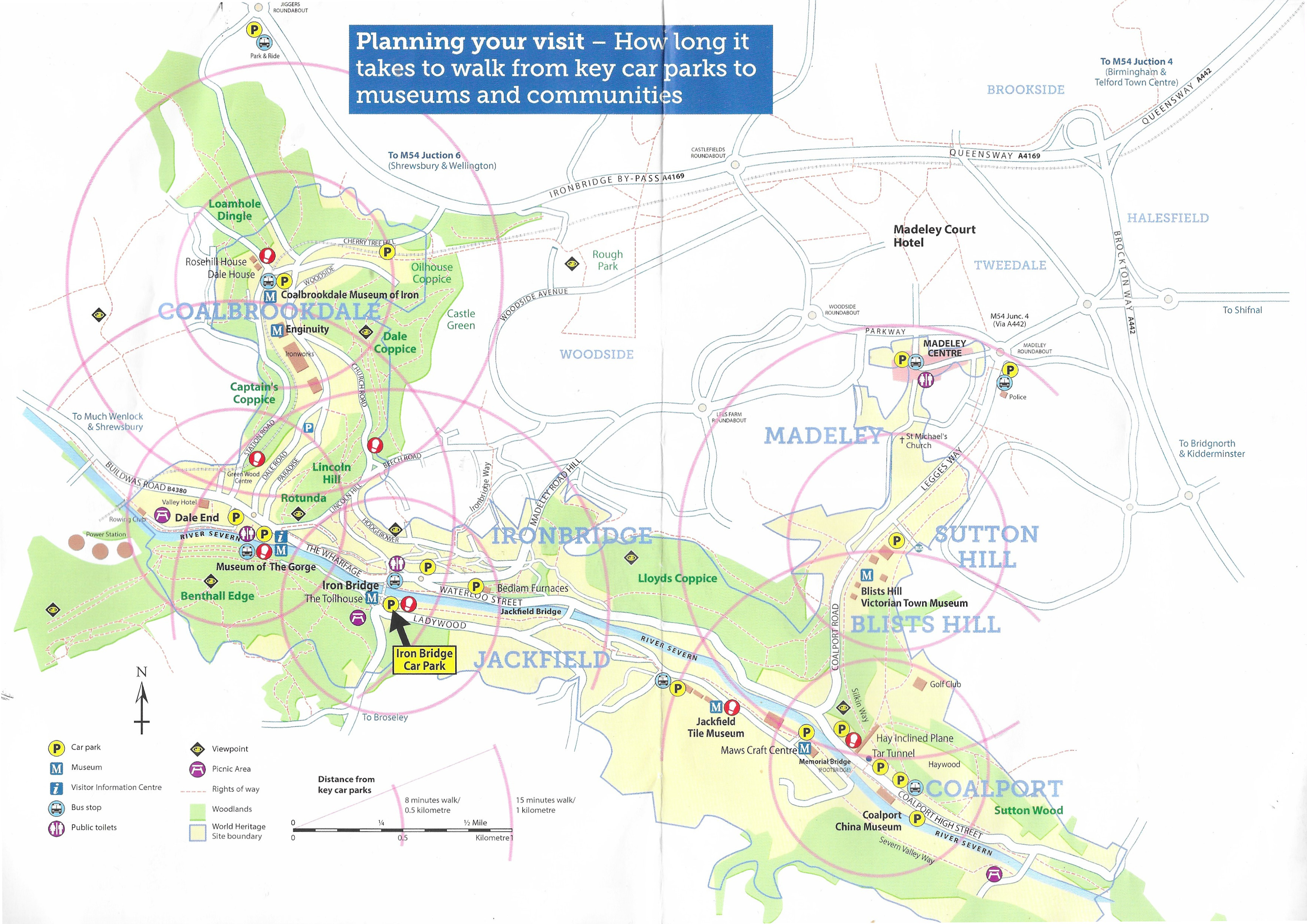
From the leaflet “Exploring Ironbridge Gorge” showing the key components of the visitor attractions today

The other essential geographical feature was the river Severn, which flows through the Ironbridge Gorge.  The gorge was itself formed by the pressure from a glacier, that sat over much of Shropshire, on the underlying trapped water.  This water, with nowhere else to go,  forced itself out from under the glacier through the soft limestone of what are now named Benthall Edge and Lincoln Hill, forming the steep-sided channel that the river occupies today.  In the 18th and 19th centuries the water from the Severn provided both power, first to water wheels and then steam engines, as well as cooling for many of the machines and as part of many of the industrial processes.  It was also a major transport link between the Ironbridge area, the Bristol Channel and the rest of the world.  Looking at the river today in its wildlife and heritage setting, it is difficult to imagine how much pollution there must have been both in the air and in the water, produced by the furnaces, forges and kilns, as well as the chemical waste.

Source: The Iron Trail, Ironbridge Gorge (leaflet), Severn Gorge Countryside Trust

The Iron Bridge

The building of a cast-iron bridge was proposed by Thomas Farnolls Pritchard 1723-1777), who also designed the prototype.  Up until the building of the bridge, which opened in 1781, most of the traffic across the river was by ferry; the nearest bridge was the medieval Buildwas bridge next to Buildwas abbey, 3.8km upstream from the site of the new Iron Bridge. The connection between the north and south sides of the river was essential, allowing the movement of raw materials, people and supplies.  The bridge was an obvious solution to the problem of a river that was vulnerable to changing levels and seasonal weather extremes such as low levels, floods and high winds.

Thomas Farnollis Pritchard by C. Blackberd c.1765

Thomas Farnolls Pritchard specialized in the restoration of prestigious houses. Although he had built bridges in wood and stone, none had been as ambitious as his Ironbridge proposal, and this was the first attempt to use cast iron to span a gap this wide. the idea was to use a single arch to span the widest section of the river, avoiding piers that would impede navigation.  He sent his proposal for a cast iron bridge to John “Iron-Mad” Wilkinson, an obvious sponsor for this type of innovative project.  Wilkinson in turn discussed the matter with Abraham Darby III, who instantly saw the potential for the bridge not merely as a means of spanning the river, but of marketing his company and the benefits of the Ironbridge area as a whole, at that time known collectively as Coalbrookdale.  A committee was formed to take the project forward.

The only known image of the bridge under construction, by Elias Martin (1739-1818) painted in the summer of 1779

An Act of Parliament was granted in 1776, and shares were soon issued to raise funds. Work began in 1777.  The iron for the bridge was cast by Darby at his works, but there is no record as to which of his three furnace sites was responsible.  It is probable that the work was shared out to all three, spreading the load to ensure that existing and new commercial contracts continued to be delivered.  It is known that wooden scaffolding was employed in the construction of the iron bridge, but the exact process of construction is unrecorded.  The painted inscription on the ironwork that spans the top of the bridge reads “This bridge was cast at Coalbrook-Dale and erected in the year MXDCCLXXIX [1779].”  Ribs were cast in two pieces and joined in the middle.  Observation of the bridge’s construction shows that it was assembled using both metalwork techniques and joinery techniques such as mortise and tenon joints and dovetailing.  The ironwork was flanked by and set into stone abutments.
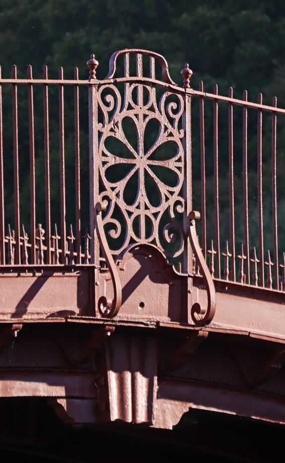
Once the basic frame was built, spanning 100ft 6ins (c.31m)  the scaffolding was removed in 1779 and a road was constructed over the top and a small toll-house added on the southern side.  The bridge eventually opened in 1781, on New Year’s Day.  Although it was built closely in the spirit of Pritchard’s original plan, several changes were made.  Pritchard did not live to see the bridge completed but his family were duly paid for his contribution.

The bridge had cost a massive £6000, twice the estimate.  Darby had taken on the bulk of this financial burden.  Although he was quick to use the marketing potential of the bridge deploying it as an advertising emblem, and visitors came from all over the world to see it, neither this nor the tolls for use of the bridge were able to make up the substantial shortfall.  Darby was unable to make up his losses and the bridge left him in debt for the rest of his life, with both business and properties mortgaged.

Unlike Buildwas and other Severn bridges, the Iron Bridge  survived the Great Flood of 1795, unlike the medieval stone Buildwas Bridge, proving the durability of a cast iron bridge.  Thomas Telford had repaired the Buildwas bridge in 1779 but during 1795 it was damaged beyond repair and, taking Ironbridge as his model, Telford replaced it with his own iron bridge.

Over the following century repairs were carried out as required, but during the early 20th century its stability was questioned and its demolition was suggested in 1926.  Fortunately, it was decided to save the bridge and was limited to pedestrian use from 1934, and was listed as a National Monument.  In 1950 it passed into the hands of Shropshire County Council.  Substantial restoration work has been carried out since 1972 to stabilize and reinforce the bridge.  It is now in the care of English Heritage.

A footpath runs under the bridge on the Ironbridge village side, allowing a good view of some of the metalwork.

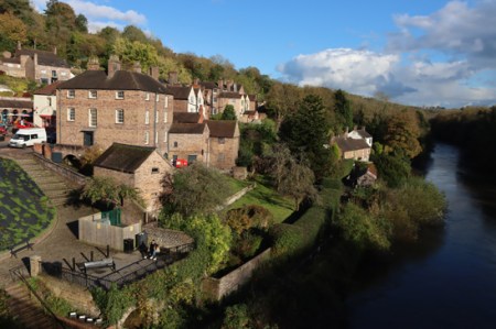
The small town of Ironbridge began to develop in the later 18th century.  Today Ironbridge village is small but attractive, with a row of shops, cafes and pubs lining the road that runs along Severn between Ironbridge and Coalbrookdale, with houses, a massive church and other community buildings climbing the hill above the river in Ironbridge.  I can recommend the ice cream 🙂

The Museums

I have already posted about the glorious Jackfield Tile Museum here, with lots of photos, but there are at least total of twelve museums and related visitor attractions in the Ironbridge area, and I will post about the other four museums that I visited on future posts.  I would have visited the Broseley Pipeworks and the Tar Tunnel, but neither were open, so I plan to visit those when they re-open.  The Darby Houses were also closed.  Nor did I visit Enginuity, which appears to be geared towards children, but actually looks like a lot of fun, if you are child-friendly, with plenty of interactive activities demonstrating engineering principals.  Blist’s Hill Victorian Town just wasn’t my cup of tea, but the recreation of everyday life in 1900 Shropshire sounds like a good initiative.
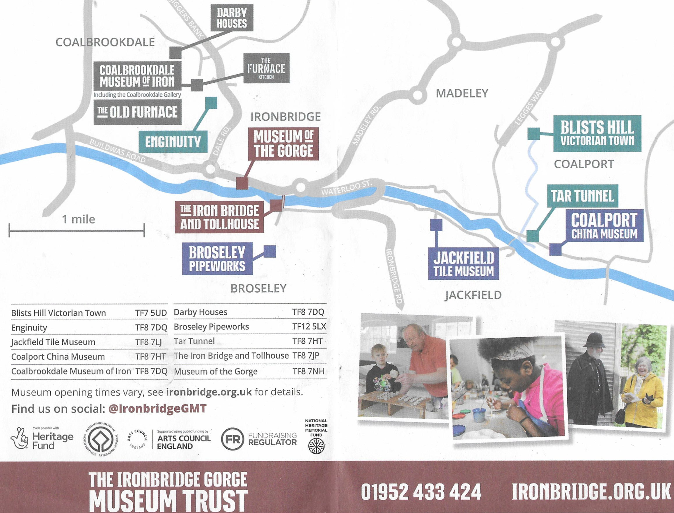
From the “Ironbridge Valley of Invention” leaflet, 2024

==

A have talked about the Jackfield Tile Museum in detail on a previous post.  Don’t miss it.  In the world of museums, this is a rock star.

Part of the Coalbrook China Museum

The Coalport China Museum to the east of of Ironbridge and Jackfield consists of two areas of interest – the displays of decorated china ware made in the local area, and the surviving furnaces in which many of them were made, which you can enter and walk around.  Although the china is worth seeing, partly because it demonstrates the many shapes, textures and patterns that were produced, I found the splendid industrial heritage of this site the most evocative and engaging part of the experience, bringing the sheer vast materiality of these enterprises to life.  This part of the Severn valley would have been full of these furnaces.  There is good car parking.  Ticket prices are on the Ironbridge website, and don’t forget to ask for an English Heritage discount if you  are a member.

The Toll House, free of charge, is set just to the south of the Ironbridge near to the car park, is now a museum of the bridge, telling it story.  This is mainly a matter of information boards rather than objects on display, but is very informative.  It also serves as a ticket office for those wishing to buy family tickets and day passes (although you can also buy tickets on an ad hoc basis when you visit individual museums).

To the east, easily reached by walking along the wide pathway that follows the Severn, is the Museum of the Gorge, also free of charge.  There is a small car park next to it.  The exterior of the building is fabulous, and there are some great internal features, and there are information boards about the history of the building and the conservation work, as well as a selection of reproductions of historic maps of Shropshire.

The Old Furnace at the Iron Museum

Up the hill is the splendid Coalbrookdale Museum of Iron.  The museum captures the essence of the area’s iron production output, from geology and early history via the bridge itself, including some excellent original images of the Ironbridge, via civil engineering equipment to a surprising and elaborate array of domestic items.  On the museum site is also the substantial and impressive remains of the the Old Furnace, some of which has been turned into an indoor feature.  Like the China Museum, this is a splendid mix of museum displays and well preserved and explained industrial archaeology.

Not shown on the above map is the Bedlam furnace, half way between Jackfield and Iron bridge on the north side of the river, which can be viewed from the laybay in front of it and is well worth visiting, partly because although there is little of it left, it was the subject of Philip de Loutherberg’s famous 1801 painting.

“Coalbrookdale by Night” by Philippe Jacques de Loutherbourg, 1801. Open coke hearths give off vivid flames and smoke. Archetypal image of the Industrial Revolution. From a colour transparency in the Science Museum Photographic Archive, CC BY-NC-SA 4.0 Licence.


Visiting

Wherever you are, keep an eye open for leaflets, as some of these have some very helpful information, including chronological charts, maps and self-guided trails to some of the features that are beyond the museums.

The bridge

The bridge is open to visitors all year round, assuming that no restoration or repair work is taking place.  The opening times for the toll house, which acts as a museum for the bridge, can be found on the Ironbridge Gorge website.  Extensive pay and display parking for Ironbridge is available on the south side of the river, which allows you to choose how long you are going to stay.  This is handy if you just want to spend a short time looking at the bridge and browsing in the village but also allows you to stay longer if you want to walk along to to Coalbrookdale to visit the Museum of the Gorge museum and up the shallow hill to visit Enginuity and the Coalbrookdale Museum of Iron.

The museums

The Iron musuem

All the Ironbridge Gorge museums are covered on one website – Ironbrige Valley of Invention.   This inexplicably has very few images of what’s on display, and suffers from Russian doll syndrome, with pages buried within pages, but the information on days when the museums are open and closed (changes seasonally) and the opening times are there if you look for them.  Some of the museums are closed completely at certain times of the year (such as the Tar Tunnel and the Broseley Tobacco Pipe Works).

Note that if you are a member of English Heritage there is a discount on ticket prices, but you will need to ask for it.

Other sites to visit in the area

This is a rich area for destinations to visit, including five medieval abbeys a relatively short drive away, a number of National Trust properties and only a little further afield, Shrewsbury makes for a rewarding day out with the abbey church, the excellent Shrewsbury Museum and Art Gallery and the attractive medieval and Georgian architecture.  Not far away is the RAF Museum at Cosford, just outside Telford (my post about it is here), and whilst there, the Church of St Bartholemew at Tong with its lovely medieval choir, its elaborate tombs and the remarkable Tudor chapel and is crammed full of interest and just a 10 minute drive away.

St Bartholemew’s Church, Tong


Sources:

Books, booklets and papers

2019 edition (no author or reference number).  Exploring Ironbridge Gorge (booklet). The Ironbridge Gorge Museum Trust Ltd.

Jones, C. 1989. Coal, Gas and Electricity. In (ed.) Pope, R. Atlas of British Social and Economic History Since c.1700. Routledge

Mathias, P. 2001 (second edition). The First Industrial Nation. The Economic History of Britain 1700-1914. Routledge.

Mokyr, Joel 1981 (2nd edition). Technological change 1700-1830.   In (eds.) Roderick Floud and Deidre McCloskey, The Economic History of Britain since 1700.  Volume 1: 1700-1860. Cambridge University Press

Osborne, R. 2013. Iron, Steam and Money. The Making of the Industrial Revolution. The Bodley Head.

Leaflets

Undated leaflet (no reference number). The Ironbridge and Town. The Ironbridge Gorge Museum Trust Ltd.

Undated leaflet (no reference number). The Iron Trail, Ironbridge Gorge. Severn Gorge Countryside Trust

2024 leaflet (no reference number). Ironbridge Valley of Invention. The Ironbrige Gorge Museum Trust Ltd.

Websites

Ironbridge Valley of Invention
Official website
https://www.ironbridge.org.uk/

UNESCO pages for Ironbridge Gorge
UNESCO World Convention
https://whc.unesco.org/en/list/371/


Day trip: The Jackfield Tile Museum, near Ironbridge, Shropshire

 Introduction

Craven Dunnill and Co

At the top of my to-do list for my short break to Shropshire in October was the Jackfield Tile Museum.  I wanted to see all the Ironbridge area museums themed around the Industrial Revolution, and managed to do so, but I have a great love of tiles, and since I moved up to this area have been dying to visit the museum in the village of Jackfield, next to the river Severn.  It was even better than I had expected.  To get the most out of this museum, you have to really love Victorian and Edwardian design, because this is a celebration of the tiles produced during the late 18th, 19th and early 20th centuries, but if you do, it is a superb experience.

The museum is beautifully thought out, very well lit, and the tiles are presented in a way that allows them to be appreciated and understood not only as designs, but as the products of specific manufacturing processes, as the result of industrial innovation and as the output of very proficient commercial drive.  It is amazing what went in to making tiles and mosaics and turning them into a commercially viable product for both private homes and public buildings.

Craven Dunnill and Co

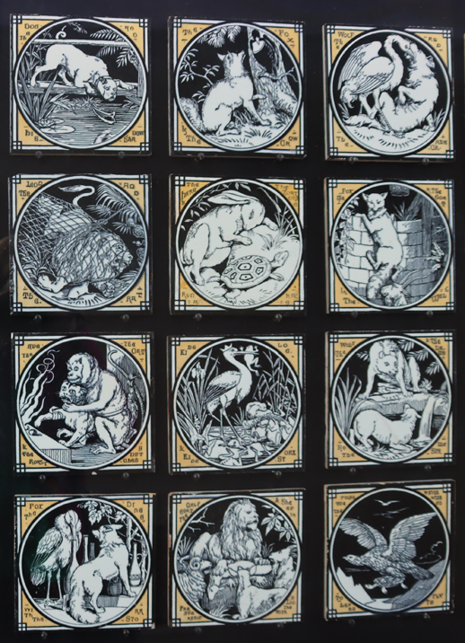
As well as original display cases and tile arrangements that show how the tiles were arranged to show to potential buyers, there are rooms showing development in artistic and craft styles (the Style Gallery) and reconstructions of entire rooms that used tiles as the major component of their decorative schemes.  There are also reminders that the tile-works also made plates, vases and other decorative items.  The museum also holds the John Scott Collection of tiles.

The impressively long 1872 building, the original Craven Dunnill and Co tile-works, is occupied partly by the museum and partly by a working tile-works.  Today’s Craven Dunnill is a successful commercial venture building on the successes of its 19th century predecessors, a very nice link between the building’s heritage and its present manufacturing activities.

Craven Dunnill and Co

Apologies for some of the photographs.  There is excellent lighting in the museum, but this sometimes makes it difficult to photograph without reflections, and many of the photographs have big patches of bright light on them.  Some of the angles are a bit odd too, as I tried to lean away from the reflections.  It didn’t help that I was in a bright fuchsia-pink coat, which reflected in the display cabinet glass!

Visiting details (with links to opening times, ticket prices, and parking details etc) are at the end of the post, as usual.

The length of the building reflects the way in which tiles were produced via a series of stages from east to west, from preparation of the clay to the finished product

The museum is arranged into different themed areas, which explain both different aspects of the Jackfield tile-works itself and the development in the 19th century of tiles and how they were marketed and sold, and what sort domestic, commercial and public locations they adorned.

Entrance, showing replica of one of the Craven, Dunnill and Co commissions


Introductory Gallery

One of the original 19th century floors of the Craven Dunnill and Co tile-works, where prospective customers entered to view tiles in the trade showroom.

The self-guided tour starts with information boards describing the background to the tile industry and its commercial development from the 17th century, when the area was famous for its clay tobacco pipe manufacturing works at Broseley.  By the 1720s there were several small potteries in Jackfield, taking advantage of locally available raw materials and the proximity of the river for power and transportation.  There had been a pottery on the Craven and Dunnill site since 1728.  The railway arrived in the valley in 1862, with a siding for Jackfield and stops at Coalport and Ironbridge, improving connections and the speed with which products could be shifted to market.  The expansion of local industries followed, and two of the largest Victorian tile factories in the world were built next to the railway:  Craven, Dunnill and Co in 1875 and Maw and Co in 1883.  Tiles were valued not only for their decorative value but, in a period that was just getting to grips with the importance of hygiene, were easy to clean.  By 1881 Craven Dunnill and Co had 94 workers including 53 men, 15 women and 25 youths.

Craven Dunnill and Co

Mosaics on the stairway up to the the trade showroom, displaying the skills of the tile-works

Craven Dunnill and Co

Craven Dunnill and Co

The Trade Showroom

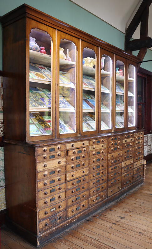
The first gallery, The Trade Showroom, is the display area of the Craven Dunnill and Co. tile-works, where architects, interior decorators and their customers could view catalogues, but could also see samples of the company’s tiles wherever they looked.  Today’s layout preserves one of the company’s original display cabinets, and the tiles on the walls, including floor and wall tiles, are based on images of this room as it was in the 19th century.  Display cabinets in the middle of the room show other aspects of the company’s operations.  On this floor there are also reconstructions of the offices that would have existed in the building in the Victorian period, with recordings that you can listen to, capturing accounts of personal memories of the tile-works in the past.

On of the original display cabinets


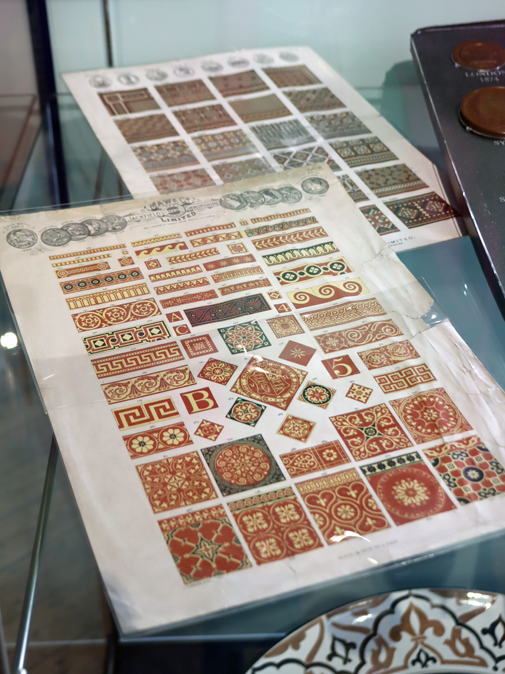
A design book by Owen Gibbons from 1881. Gibbons and his brother taught at the Coalbrookdale School of Art, producing many tile designs

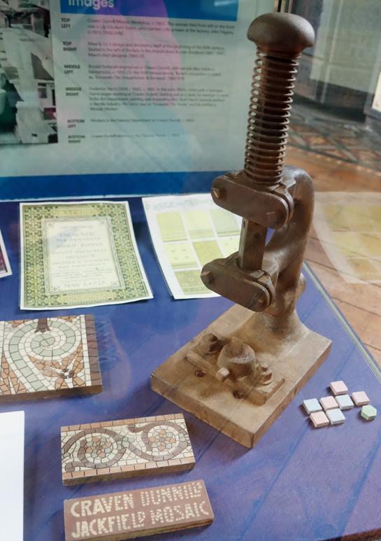
Mosaic cutter


Style Gallery

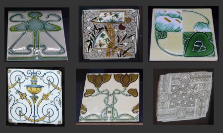
The Style Gallery offers an eye-dazzling view of the sheer number of fashions in tile design that trended during the Victorian period.  It is a reflection not only of how the Victorians were interested both in referring to and interpreting the familiar past, and reinventing the present but of how some of these styles employed imagery from the Far East and and the Middle East.

Both companies used well-known designers for some of their output, but much of the design work was done by in-house designers, some of whom were secured from the Coalbrookdale School of Art.  This was a rare opportunity for women to enter industry as skilled artisans.


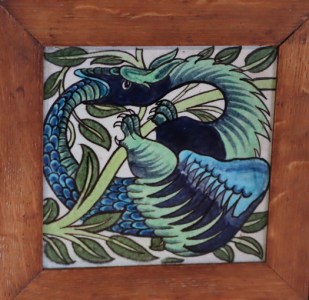
William de Morgan

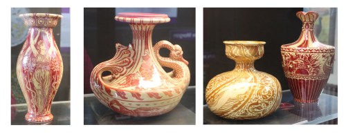
Examples from a series of 7 Art Pottery vases by Walter Crane for Maw and Co, 1889


Tiles in Everyday Spaces

This area of the museum is superb, recreating some of the real-world contexts in which tiles manufactured were employed.  It was great to see the Covent Garden tube station recreation, because that was my tube station for several years when I worked for a company on Long Acre.  And if I could have had a glass or two at that wonderful tiled bar, what a great destination that would have been!

Butcher’s shop, Ripon by Alfred Potter for Maw and Co

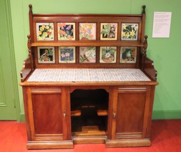
Washstand by Maw and Co., c.1883

Long Gallery

The Long Gallery is elegantly displayed and beautifully designed, showing both sides of individual tiles, and demonstrating the variety of methods and techniques as well as styles and designs manufactured locally.  Each of the displays shows a different decorating technique accompanied by tiles, with both front and back display, that illustrate that particular technique or method.


From the Long Gallery to the John Scott Gallery

Between the Long Gallery and the John Scott Gallery is a corridor with views into the historic mould store, and a panel on the corridor wall consisting of more historic moulds.  These all have relief patterns that were drawn on and then hand-carved.  To make the tile, the clay was pressed or poured into the mould, and then fired.  Once it had cooled it could be glazed, before being fired again.  The ones stored here are part of the commercial and industrial heritage of Maw and Co and Dunnill Craven and Co.


John Scott Gallery

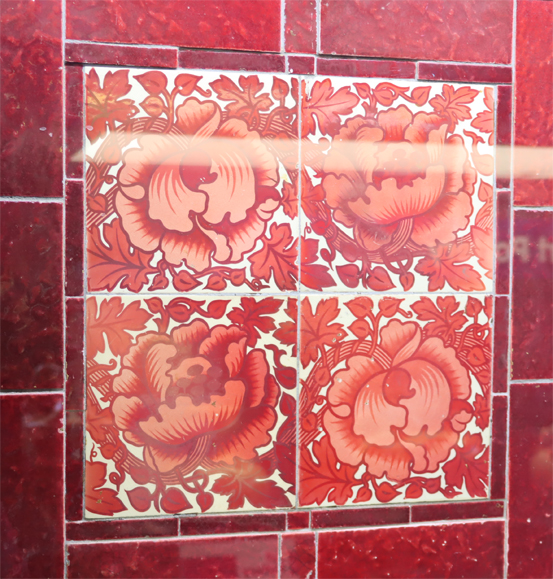
Part of a six-tile panel showing a peony design, attributed to Kate Faulkner, Morris and Co., 1880s

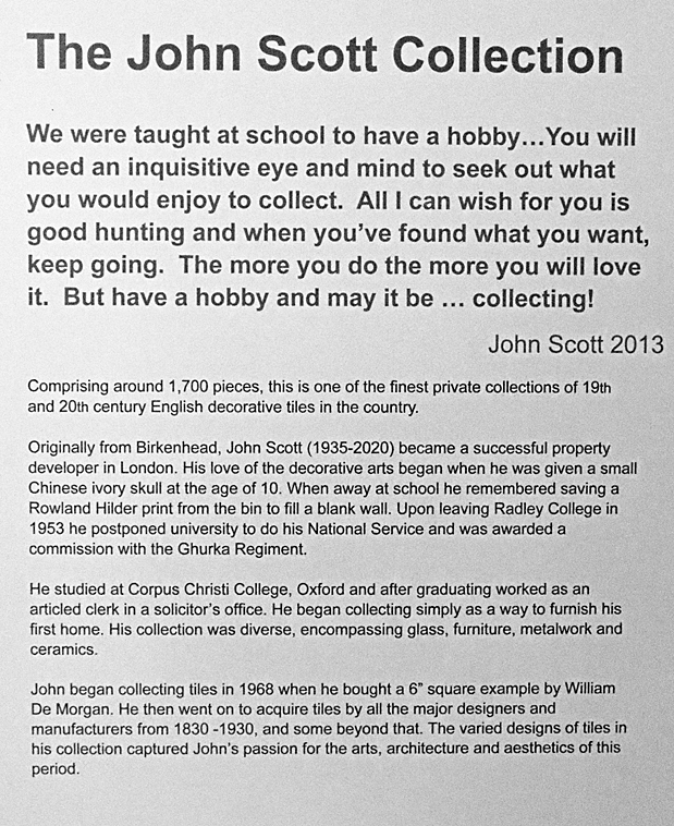
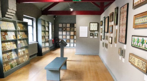
Slightly anomalous, because this is a collection that does not relate specifically to the Ironbridge area, this gallery displays the collection of John Scott, who began collecting tiles in 1968 and continued until he died in 2020.  His collection, gifted to the museum in 2013, includes over 1700 pieces, of which an elegant portion are displayed here.  I really liked his statement, shown on one of the information panels, that he collected only what he both liked and could afford.  He was collecting for his own pleasure, not to build an illustrious collection.  By the time he died, his collection had become a remarkable reflection of the history of tile design and manufacturing.
===

Uroboros, sometimes signifying eternity. By C.F.A Voysey. Pilkington


William de Morgan


One of six panels designed for Membland Hall, Devon. William Morris and William de Morgan 1876

Fish and water lilies. Relief-moulded tile panel design by C.F.A. Voysey, Pilkington

Art Nouveau tile panel by John Wadsworth. Minton Works c.1910. The repeat is achieved with just one tile.

Exterior buildings

Once you leave the museum, you will walk out through some of the original buildings that supported the works, including the massive kilns and storage facilities.  From here, you can re-enter the museum to visit the gift shop and the cafe before leaving.


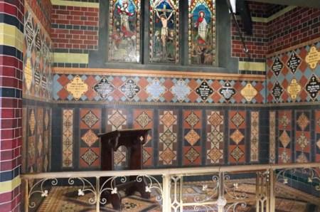
When you leave, the church next to the tile-works is well worth a look, with a partially tiled interior.

Final Comments

All of the museums in the immediate Ironbridge area are well thought out and beautifully presented, and I enjoyed them all enormously.  The Jackfield Tile Museum was the one that most closely demonstrated domestic and commercial artistic tastes throughout England.

The museum offers an impressively detailed insight into multiple aesthetic tastes captured by Victorian tiles and mosaics, showing dozens of them to ensure that visitors are able to appreciate the sheer versatility and exuberance of Victorian taste.  Seeing the tiles built into pieces of furniture, and used to create entire spaces like churches, bars, bathrooms and the Covent Garden tube station brought the tiles to life, showing them both as aesthetic decisions and practical architectural applications. 

Even though the visual impact of the tiles was always going to steal the show, the museum does not neglect explanations of the really fascinating history of the local tile-works, the development of the manufacturing technologies that went into creating tiles and mosaics, and details about the commercial challenges involved in the marketing and sale of both.

I really loved it.


Visiting

Be careful with the opening days, because when I visited it was closed on Monday and Tuesday, but these days, and the times, change depending on the time of year. If you are intending to visit other museums too, it is worth checking out if they are open at the time of year of your visit.  The Broseley clay tobacco pipe works, for example, was closed for the autumn-winter season, which was disappointing.  You can find prices and opening times on the museum website here, and if you want to see other museums too there is a page with all the opening times in the related museums here.

If you are a member of English Heritage be sure to hand over your card, whether asked for it or not, to obtain a 15% discount.

There’s no guide book, which is a shame.

Jackfield Museum has a car park, which is chargeable via some sort of online arrangement that is loosely described on the website here.  I was staying nearby so walked down to the museum and didn’t need to get to grips with the parking system, but I suggest asking at the ticket desk if you have trouble with it.

Nearby there’s an excellent pub called the Black Swan with tables overlooking the Severn outside, and a cosy, friendly interior with excellent pub food.  It has a really super, mellow atmosphere and is a two-minute drive away, with plenty of free parking.  It has no website but it has a Facebook page and if you Google it, the phone number will come up.  It is quite small, so best to book by phone or in person.

==


A walk from Waverton towards Chester along the Shropshire Union Canal

I have driven over the canal bridge on Eggbridge Lane in Waverton so many times thinking that I really must take advantage of the little car park just before the bridge to go and take a stroll down the towpath.  Having woken up early on a sunny morning I decided to investigate. Waverton is just off the A41, so very easy to reach. The car park is quite small, but it was not full even on a bright and warm morning.  The What3Words address for the car park is ///fingertip.snored.deals

Victoria Mill, Waverton

Immediately opposite the car park, as you walk to the towpath, is a very attractive canal building, the Grade 2 listed, a mid-19th century Victoria Mill, a former steam-powered canal-side corn mill, with bays for loading and unloading narrowboats, and now converted for modern use. The Historic England description is here.  This is part of the heritage of the Shropshire Union Canal, which if you keep walking north eventually ends up at Ellesmere Port.  To the south, it eventually connects up with the rest of the main canal network at Hurleston Junction.  The Shropshire Union has quite a complicated history, as does Chester’s canal heritage as a whole, and was not completed until 1835.

As with most canal walks, there’s always a choice to turn right or left, and as I had no idea what to expect from either direction I decided to head north, leaving the walk south for another occasion. Out of the car park I turned left under the unprepossessing bridge no.119 and headed up the towpath.  This section is metalled, so it avoided the mud and sludge that I had been half expecting.

If you take this route you find yourself walking along a short row of houses with canal gardens along a metalled pathway.  Canal-side gardens are always fascinating.  I used to live on a narrow boat many years ago, and it is always a lot of fun to see how different minds have dealt with a garden that opens directly on to a canal.  These are always hugely individualistic and personal.  There is always much to see in the way of garden furniture, garden ornaments (someone will always have gnomes, and there is usually at least one example of traditional canal painting), sheds in various states of repair, a wide range of summer houses, varieties of approaches to terracing, often some very interesting specimen trees and shrubs, and different attitudes to garden seclusion, along a spectrum from solid barriers of hedging or fencing to a complete lack of interest in any form of privacy.  A real cultural treat.

After just a minute or so the towpath enters a more rural section, and in the late season sun it was a real pleasure to take in all the autumnal colours on trees and shrubs that flank the canal.  I’ve posted some of the photos below. It’s a well-used section of towpath, with joggers, cyclists and plenty of dog walkers, but everyone is very civilized about moving over to make passing easy.  There was not much in the way of canal traffic, with just two narrowboats on the move, but I expect that it is much busier in summer.

Keep an eye out on your left as you leave the housing on your right and reach the more rural section.  Partly concealed by the grass next to the towpath, there is a short inscribed red sandstone Parish Boundary Marker. This section of the canal passes through the parish of Rowton, famous for the Civil War Battle of Rowton Heath (see the Wikipedia entry on the subject and a more detailed analysis by Historic England).  King Charles I is said to have watched his army lose that battle from the Phoenix Tower that still stands on Chester’s city walls. The stone marks the boundary between the parishes of Christleton (CP on the stone) and Rowton (RT).  The date commemorates the date of the battle in 1645 and, below the level of the grass, 1995, the 250th anniversary of the battle.
===

After this more countrified section there are more houses, all interesting, with some lovely weeping willows and other water-loving species, and a very attractive hump-backed bridge, that I have since discovered carries Rowton Bridge Road into Christleton.  I walked up as far as The Cheshire Cat, which sensibly has a gate onto the towpath, and carried on just a short way beyond it, but at that point the canal converges closely with the A41 (Whitchurch Road) and it becomes quite a noisy experience with the unremitting traffic, especially during the week.

Checking the map later (for example see the plotaroute.com website), I note that by coming off the towpath at Rowton Bridge it is possible to walk into the attractive village of Christleton, with its marvellous pond, and I would have done this had I realized.  Another time.  had to be somewhere else in the afternoon, so it was a short walk, probably an hour and a bit there and back at strolling pace, with pauses to let bicycles pass, and to take photographs.

For those with unwilling legs (see the blog’s Introduction for details about what this refers to), the towpath heading north from Waverton is metalled, but quite uneven.  No problem for most people, I would have thought but do keep an eye on it.  There are places where the edges of the surface are particularly uneven, but this just means that if you are with someone else you need to go in single file for short sections.  Otherwise, it’s on the flat and very enjoyable.

On the way back I followed the towpath beyond the car park for a few minutes to see how far the housing that backs onto the canal extended.  This part of the towpath is not metalled, was muddy and is single-track.  These houses and gardens are another interesting mixture – each of the sections of housing and gardens has its own personality, presumably reflecting both when it was built and the pricing.  These look as though the garden-canal margins were all designed with narrowboats or other canal vessels in mind. There was indeed one narrowboat moored up at a garden.  The housing stops after a couple of minutes and the towpath reverts to a far more rural appearance.  I’ll investigate further on another day.

The 1715 “Old Dock” – The earliest of Liverpool’s commercial docks, preserved beneath the Liverpool ONE shopping centre

Introduction

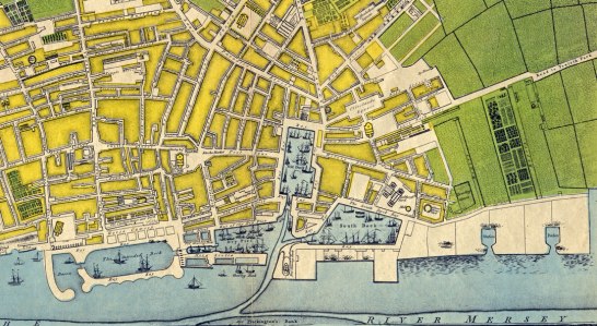
The Eyes map of Liverpool showing Old Dock on a previous tidal inlet and enclosed within the streets of an expanding Liverpool in 1765, 50 years after it first opened. Later docks were laid out along the foreshore. Source: National Museums Liverpool

Earlier in summer 2024 I went on the Old Dock tour in Liverpool when it was offered one Sunday.   Old Dock, of which only one corner remains to be visited, was perhaps Liverpool’s most important commercial and civil engineering initiative at a time when Chester’s port was going into decline and Liverpool had the opportunity to become the trading centre for the northwest.

Old Dock, Liverpool

Old Dock in Liverpool, the first of Liverpool’s impressive network of enclosed docks, opened in 1715, to the design of civil engineer Thomas Steers.  It is Europe’s oldest enclosed cargo-handling dock.  What remains of Old Dock is underground, beneath the “Liverpool ONE” shopping centre.  Its lock gates can no longer be visited, but remain under The Strand (the modern dual carriageway that runs along the line of the old foreshore).  Only the northeastern corner of the dock is accessible to visitors, and has been provided with a gantry and information panels, and its history is presented to pre-booked groups by an excellent guide.  I’ve added details about booking and the tour itself at the end of the post under “Visiting.” The following looks at some of the history of Old Dock.

The 1699 Howland Great Wet Dock in London. British Library HMNTS 10349.ff.9.. Source: Wikipedia

Old Dock was modelled on the Howland Great Wet Dock, shown right, built in 1699, which was built to shelter ships, mainly of the East India Company, in the days when ships over-wintering on the Thames were regularly subjected to both storm damage and piracy.  It was surrounded by a double planting of trees to help protect the ships within and had shipbuilding dry docks at its entrance. It was a convenient place to carry out repairs and to ready ships for the upcoming season, but was not used for handling cargo so was not a commercial trading dock.  The Howland Great Wet Dock was built in a rural space on the south of the Thames in what is now the residential Surrey Quays area of southeast London, and was replaced in the 18th century by Greenland Dock, which itself became part of the Surrey Commercial Docks.

The commercial argument for Old Dock

Liverpool was established by a charter of King John in 1207 and was provided with a castle in 1235.  At this time, however, Chester was the main northwestern port, and Liverpool did not become a commercial giant until the 18th and 19th centuries, and this required some pioneering Victorian thinking and civil engineering before it really took off as one of Britain’s leading ports.  Old Dock is at the heart of this story.

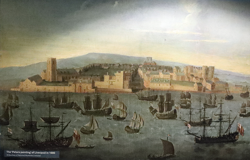
Painting of Liverpool in 1680, from the Old Dock display area. Unknown artist. The original is held by the National Maritime Museum. See more (and a better image) on ArtUK

Before the docks, the Mersey was not the easiest of rivers to use in an age of sail partly due to strong winds but also because of the twice-daily tidal events that swept down the estuary. An additional problem was that due to the dumping of rubbish and ships’ ballast along the river edges, deep-sea shipping was unable to approach the river banks to offload and reload.  It could also become very busy with river traffic of all shapes and sizes. The handling of cargo on the Mersey was achieved by mooring ships in the main channel and loading and offloading them with lighters – unpowered boats into which the cargo was loaded by hand, then rowed to shore, and offloaded by hand.  This could only be carried out between tidal events, confining the activity to around 5 hours a day. To empty a single ship averaging 150 tons could take between two and three weeks.

The engineering success of the Howland dock enterprise inspired MP Thomas Johnson, who was both a successful merchant a slave trader, to approach one of the engineers probably responsible for the Howland dock, George Sorocold, to discuss the viability of a similar dock for Liverpool.  Johnson, however, saw the greater potential of an enclosed inland dock, not for over-wintering ships but for creating a cargo-handling facility to radically improve speed and efficiency. Under The Dock Act of 1708 a Common Council of leading city figures was established to became trustees of the proposed dock, which they operated through council committees.  The risk of doing it this way rather than as a private enterprise was that failure could have put the entire city finances in jeopardy.  Thomas Steers from London was the civil engineer appointed in 1709 to make this a reality, only a decade after the opening of the Howland Great Wet Quay on which he had probably also worked.  Initially costs had been estimated at £6000, but this was a serious underestimation and eventually the dock cost more than double this amount.

Building and opening the dock

The dock was lined with bricks in the upper sections with local red sandstone in the lower courses.  I am accustomed to the later Surrey Commercial Docks in southeast London, where I used to live, which are lined with stone much like Liverpool’s Albert Dock, so the sight of a brick-lined dock seemed extraordinary to me.  The bricks were made on site from local clays, with a dedicated kiln built for the task, and a special mortar was used to resist the incursion of water.

At the base of Old Dock, Liverpool

The result of all the investment, civil engineering and labour was Old Dock, which opened in 1715 at the mouth of a former tidal inlet or creek.  Up to a hundred ships could be taken into the 3.5 acre dock via a 30ft wide entrance lock and could draw up against the quayside to offload without the use of lighters. Because of the tides, ships could only enter the dock at the top half of the tide, but a 1.5 acre tidal entrance basin was provided as a waiting area.  By drawing ships up against the quayside, three weeks could be reduced to just one to two days.  The proof of concept was soon confirmed.

The area around the dock was soon surrounded by residential, commercial, retail and service industry premises. Excerpt from a poster from the Old Dock exhibition area.

An entire new residential, commercial, retail and service industry quarter grew up around the dock, which became known as the Merchants’ Quarter.  As well as homes, warehousing and other commercial facilities there were lodging houses for sailors, and less salubrious businesses that catered to their needs.  This is a good illustration of the sort of process of urban sprawl that follows on from a specific industrial development.

Old Dock was such a notable success that new docks were soon opened, and the Liverpool foreshore began its transformation.  During the 18th century South Dock, also built by Thomas Steers (later Salthouse Dock) opened 1753, George’s Dock opened 1771, King’s Dock opened and Queen’s Dock opened in 1796.  It is a measure of the success of the dock concept, Old Dock having been established 53 years before Bristol’s first dock, that between 1772 and 1805 the total tonnage of shipping increased from 170,000 to 670,000, with foreign shipping increasing from 20,000 to 280,000.  By the end of the 19th century 9% of all world trade passed through the Liverpool docks, and there were 120 acres of enclosed docks along 10km (7 miles) of Liverpool’s foreshore.

Closure of the dock

Old Dock, Liverpool

Old Dock itself closed in 1826 mainly because as ship sizes increased, in terms of width, length and depth, it became increasingly obsolete.  It did not help either that the dock had become surrounded with other buildings and could not easily expand without considerable destruction.  Instead, the development of docks beyond the existing foreshore seemed like a better option and this is what happened.

This new use of enclosed docks for cargo-handling was pioneered at Old Dock in Liverpool, creating the first revolution in cargo handling in the UK.  To provide additional real estate for the rapidly growing city, most of the dock was infilled and built over, so this one remaining corner is a significant survivor from Liverpool’s early development as a major trading port.

Final Comments

Old Dock brickwork

Much of what is known about Liverpool’s earliest docks comes from the archaeological investigations that took place between 1976 and 2009. Old Dock was examined prior to the building of Liverpool One by Oxford Archaeology between 2001 and 2006. The remains of Old Dock are designated a site of Outstanding Universal Value.

It is difficult to over-emphasize how important London’s Howland Great Wet Dock and Liverpool’s Old Dock were to the development of maritime trade in Britain.  With an enclosed dock designed by Thomas Steers, the Old Dock set Liverpool firmly on the path for trading success throughout the 18th century and the commercial and architectural triumphs of the Victorian period.

Visiting

Booking details, opening times, ticket prices and everything else you need to know are on the Old Dock Tour website.

At the time of writing the meeting point shown on one place on Google Maps is in a different location from the one that is shown on the Old Dock Tours website, and the latter is the correct one.  I don’t know Liverpool at all and I was confused by the directions on the website, partly because I had no idea what a “Q-Park” might be when it escaped from its burrow, so I arrived early to make sure that I was in the right place, which was on the Thomas Steers Way entrance to the “Q-Park” (the Liverpool ONE car-park), on the left as you head up from the Mersey, near the base of the Sugar House Steps.  Here’s the What3Words address for that location, which is traffic-free, but do check on the website or your ticket that this remains the same meeting place: https://what3words.com/found.farm.gent. Have your ticket handy to be checked, either printed out or on your device.

This is a guided tour.  You receive an excellent lecture as you walk to the dock via a wall-sized map of old Liverpool, and then stand on the  gantry looking down into the dock. Our guide was informative, humorous and engaging, parting with a staggering amount of information in an easily digestible way.  It is always a mark of how well a guide does when there are questions afterwards, people wanting to explore specific aspects of the story, and there were lots of questions.  I used to live overlooking Greenland Dock in London, and the remnants of the Surrey Commercial Docks were my home for twenty years.  Opposite was Canary Wharf, where the former East India and West India quays are preserved and the Museum of London Docklands is located. It was a real dock heritage experience, so it was particularly nice to go to Liverpool and have someone bring this particular old dock to such vivid life.

If you are dealing with unwilling legs, there is a flight of steps with a banister to hold onto.  I forgot to count, but I would guess perhaps ten steps, down from the car park entrance into the dock area.  There is then a gantry (metal walkway) across the remaining part of the dock, with high sides to hang on to.  There is nowhere to sit, so a portable perch of some sort might be useful whilst you are listening to the talks.

I had not realized that it was the schools’ half term break.  Half-term was a poor day to visit Liverpool, and on the tour there were two completely uncontrolled young children running around and yelling their heads off.  A less child-intensive day would be better if it can be arranged.  There’s not a lot for young children to see on this walk anyway, although an older child seemed to be enjoying it very much.
———


—–

Sources

Most of the above details came from the guided tour.  I did not want to detract from that so I have not gone into greater detail here, but I did use some additional sources to check facts that I had not noted down at the time, and have provided some suggestions for further reading.

Books and Papers

Farrer, William, and Brownbill, J. (eds.) 1911. Liverpool: The docks, in “A History of the County of Lancaster: Volume 4,” p. 41-43. British History Online. Originally published by Victoria County History, London, 1911.
https://www.british-history.ac.uk/vch/lancs/vol4/pp41-43

Gregory, Richard A., Caroline Raynor, Mark H. Adams, Robert Philpott, Christine Howard-Davis, Nick Johnson, Vix Hughes, David A. Higgins 2014. Archaeology at the Waterfront vol 1: Liverpool Docks. Lancaster Imprints / Oxford Archaeology North

Stammers, M.K. 2007.  Ships and port management at Liverpool before the opening of the first dock in 1715.  Journal of the Historic Society of Lancashire and Cheshire, vol.56.
https://www.hslc.org.uk/journal/vol-156-2007/attachment/156-3-stammers/

Stephenson, Roderick A. 1955. The Liverpool Dock System.  Transactions of the Liverpool Nautical Research Society, Volume 8 1953-55 (1955)
https://liverpoolnauticalresearchsociety.org/wp-content/uploads/2019/03/Article-The-Liverpool-Dock-System.pdf

Websites

National Museums Liverpool
Ten fascinating facts about Liverpool’s Old Dock
https://www.liverpoolmuseums.org.uk/stories/ten-fascinating-facts-about-liverpools-old-dock

Historic Liverpool
1846: Plan of the Liverpool Docks, by Jesse Hartley, Dock Surveyor
https://historic-liverpool.co.uk/old-maps-of-liverpool/1846-plan-liverpool-docks-jesse-hartley-dock-surveyor/#4/65.79/-74.43

The Liverpolitan
Old Dock: a different view. Wednesday, 18 November 2015
https://theliverpolitan.com/blog_old_dock_a_different_view.php

That’s How The Light Gets In blog
Liverpool Old Dock: Down to the bedrock
https://gerryco23.wordpress.com/2010/09/14/liverpool-old-dock-down-to-the-bedrock/

Liverpool World Heritage
LIVERPOOL MARITIME MERCANTILE CITY WORLD HERITAGE SITE MANAGEMENT PLAN 2017 – 2024. Prepared by LOCUS Consulting Ltd. Liverpool City Council
www.liverpoolworldheritage.com/wp-content/uploads/2018/09/pmd-486-liverpool-whs-management-plan-final-version-as-at-27-sep-2017.pdf

A Rotherhithe Blog
The Howland Great Wet Dock 1699-1807
http://russiadock.blogspot.com/2008/06/rotherhithe-heritage-2-howland-great.html

—–

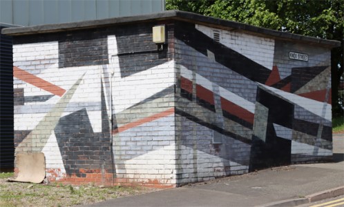
Dazzle-camouflage building on Knox Street in Birkenhead

At Birkenhead Priory the other day I very much liked this small building on Knox Street, very close to both Birkenhead Priory and the Cammell Laird shipyard.  It has been painted in the style of dazzle camouflage, used in the First World War, and to a lesser extent in the Second World War, primarily to confuse submarines.  “The primary object of this scheme was not so much to cause the enemy to miss his shot when actually in firing position, but to mislead him, when the ship was first sighted, as to the correct position to take up. Dazzle was a method to produce an effect by paint in such a way that all accepted forms of a ship are broken up by masses of strongly contrasted colour, consequently making it a matter of difficulty for a submarine to decide on the exact course of the vessel to be attacked” (Norman Wilkinson, 1969, A Brush with Life, Seeley Service, p.79, quoted on Wikipedia).

The moment I saw it, it reminded me of a 1919 painting by Edward Wadsworth (1889 – 1949) that I have hanging in my spare bedroom, showing a ship in dry dock in Liverpool receiving its new paint job.  Wadsworth painted in the style of the Vorticists, whose best known proponent was Wyndham Lewis, inspired by machinery and industry, and focused on clean lines, hard edges and planes of strong colour.  The dazzle ship was a near perfect subject matter for this style of painting, and Wadsworth was in an ideal position to get up close and personal with his subject matter, as in the First World War he worked as an intelligence officer, and one of this responsibilities was implementing dazzle camouflage designs for the Royal Navy.

I would love to know who came up with painting the building on Knox Street in the same style.  If you know anything about it, do let me know.

Below is a painting from the Merseyside Maritime Museum showing the Walmer Castle painted in her dazzle camouflage.  “The Walmer Castle was launched in 1901 for the recently created Union Castle Mail Steamship Company. The ship sailed between Southampton and Cape Town and in 1917 was requisitioned by the British Government. It is seen here dazzle painted for use as a troop ship in the North Atlantic. Walmer Castle survived the war and was broken up in 1932″ (National Museums Liverpool).

Monument to the building of the Queensway Tunnel under the Mersey, Birkenhead

On a recent visit to Birkenhead Priory, which I am still writing up, I arrived some time before the Priory opened, and went for a wander.  There are some great things to see in the area, but this combined monument and street light really drew the eye.  I decided not to risk life and limb by flinging myself across the very busy road to read the inscription at its base, so did a web search when I returned home.  It is a monument to the building of the Queensway Tunnel under the Mersey.  It is Grade II listed (1217871), was designed by Herbert Rowse and erected in 1934.  It was shifted from its original position in 1970 due to changes in the road layout at the tunnel approach, but originally illuminated the first concourse / plaza.

The monument has the fluted elements of a Doric column clad in impressive black granite, hints at ancient Egyptian lotus-top capitals, has a light on top, and simply yells Art Deco creativity and optimism, with a touch of eccentricity.  It is such a hybrid of different ideas, incorporating ancient art and contemporary technology, and happily combining the functions of both monument and lighthouse that it has no chance of being rationally categorized.  Like Greek and Roman columns or ancient Egyptian obelisks, it looks as though it ought to be in company, not standing all on its own.

The monument did in fact have a twin, but instead of standing alongside its sibling was erected over the river in Liverpool, lighting the other entrance to the tunnel.  Sadly this was taken down in the 1960s, a period when so many bad decisions were made regarding architectural heritage.  There was some talk in the media this time last year about erecting a replica, but I don’t know if that plan went anywhere or has been abandoned.

The inscriptions on the bronze plaques on the base display the names of the engineer responsible for the civil engineering of the tunnel, Sir Basil Mott J.A. Brodie and the architect Herbert Rowse, as well as the names of the team who built the bridge and the  construction teams and committee members who oversaw proceedings.  The commemorative declaration reads:

Queensway, opened by His Majesty King George V, 18th July 1934 accompanied by Her Majesty Queen Mary.  The work on this tunnel was commenced on 16th December by Her Royal Highness Princess Mary Viscountess Lascelles, who started the pneumatic boring drills at St George’s Dock Liverpool MCMXXXIV

I love the monument.  It has a real sense of joie de vivre. It is a shame that it is no longer located closer to its original position as part of the tunnel’s original architectural vision.  On the upside, at least it has been preserved and not demolished like its twin.  Other aspects of the original Art Deco vision do survive in situ at the tunnel entrance, shown above right.


Sources:

Ariadne Portal
Monument to the building of the Mersey Tunnel, Birkenhead Statement of Significance
https://portal.ariadne-infrastructure.eu/resource/81de5df3ed3619b3a955851dd28c44311e65fcefde36d151d655fdb6f35d49c2

Historic England
1217871
https://historicengland.org.uk/listing/the-list/list-entry/1217871?section=official-list-entry

Chester Standard
Restoration plan for Liverpool entrance to Queensway Tunnel
https://www.chesterstandard.co.uk/news/23587848.restoration-plan-liverpool-entrance-queensway-tunnel/

Liverpool Echo
Replica monument could be installed to mark Mersey Tunnel history
https://www.liverpoolecho.co.uk/news/liverpool-news/replica-monument-could-installed-mark-26238865

Wikipedia
Monument to the Mersey Tunnel
https://en.wikipedia.org/wiki/Monument_to_the_Mersey_Tunnel

The Roman Bath House at Prestatyn

Introduction

The Roman bath-house at Prestatyn, discovered in the 1930s, is located in a rather nice little housing estate on the edge of Prestatyn, which hems it in but does not overshadow it.  Today the site is pleasantly presented in its own space, accessed via a gate.  There are two information posters, and a raised area from which one can look down into the site before walking in and on it.  There has been a lot of work carried out to stabilize and preserve it with concrete and mortar, so it is a distinct mix of old and new, but the essential layout has been preserved.  On the day that we were there, a blue tarpaulin was lying over a small part of the walkway around the site, presumably either due to unsecured damage or to protect repairs.

Roman sites in Clwyd. Source: Blockley 1989, fig.5 p.9. Click image to enlarge

Excavations in the 1930s (Professor Robert Newstead), the 1970s and again in the 1980s (Kevin Blockley for CPAT) revealed an Iron Age farmstead (to be described on a future post) and a Roman and Romano-British (indigenous) settlement dating from the late 1st century AD, some time soon after AD 70.  The combined excavations revealed a Roman complex of structures over a number of periods.  The main period of Roman and Romano-British activity, spanned two periods, defined by Blockley as IIA and IIB.  This included eleven timber buildings, seven in Phase IIA and four in IIB, a water well, and three stone-built buildings, including the bath-house with its furnace and its water management system.  The bath-house itself was built in around AD 120, quite late into the history of the site, and was extended in AD 150.  The entire group of buildings appears to have gone out of use towards the end of the 2nd century.  Originally it was thought that the bath-house and other buildings may have been outliers of a fort.  There is no known fort in north-east Wales in spite of the existence of other Roman sites and three Roman roads, and it was hoped that this might fill a gap in the data.

The Bath House

Detail from one of the information boards at the site showing the various components on the ground

Today all that remains visible of this complex of buildings is the bath-house. When it was found, much of the bath house and surrounding area were covered with c.60cm (2ft) of rubble, described by Newstead as:  “tumbled masonry, broken roof tiles, bricks and quantities of tile-cement flooring etc” a well as box tiles and ridge tiles.

The foundations of the bath-house preserve the main features of a very small but classic Roman bath house, the plan of which is clearly visible on the ground. It measures c.11.7m x 4.5m (c.38 x c.15ft).  What you can see today was the under-floor part of the bath-house.  Over the top of most of these features, except for the D-shaped plunge pool, would have been a tiled floor.  The bath-house was built in two phases.

The bath-house in AD 120

Antefixes from the Roman bath house at Prestatyn. Source: Newstead 1937 (National Library of Wales)

The walls of the building consisted of three courses of ashlar (dressed stone, to present an attractive appearance) filled with rubble and mortar to create the thick walls visible today.  The rubble within the outer walls was locally sourced, probably picked out of glacial soils near the site.   Of the exterior ashlar, Newstead found purple micaceous sandstone blocks in situ along the base of the northern wall of the bath house, the nearest source of which was around 6 miles away (and can be seen in use today at Rhuddlan Castle and St Asaph’s Cathedral). Broken roof tiles were also used in the construction.  Inner walls might have been plastered and could have been decorated.  The roof was tiled, and provided with decorative triangular antefixes showed LEG XX V V legend as well as the legion’s wild boar emblem, which like the tiles were provided with stamps identifying them as work of the 20th Legion.  The 20th Legion’s tile-works at Holt near Chester clearly provided the tiles and bricks required or the bath-house in AD 120, and it is possible that they assisted with the construction works, but there is no sign that this was a legionary base, or that the 20th Legion controlled whatever activities took place at the site.  Apart from the tiles and bricks, all of the stone used at the site was sourced within a few miles of the site.

Information board in the Grosvenor Museum, Chester, showing how antefixes were used


The first phase of the bath-house with the hot room and warm room in Period IIA. Source: Blockley 1989

The plan to the left excludes the later cold room (frigidarium) with the D-Shaped plunge bath, showing the stone-built components of the bath-house in AD 120, when the bath house was built.  There is no sign of a stone-built cold room, which was was either missing, which would be very unusual, or was built of wood.  The two rectangular rooms, both of which sat over two hypocausts were both built in this first phase.  Hypocausts are artificial floors set on small pillars made of bricks and tiles (pilae) into which hot air, supplied by a furnace, is channelled.

In the tepidarium, Room B, Newstead found only two of the short hypocaust pillar bases, each bearing the stamp of the 20th Legion.  An internal doorway gave access to the Room C, the hot room or calidarium which was nearest to the furnace, where the remains of another fourteen pillars (pilae) survived.  The pillars were made of a c.28 x 28cm (11 x 11 inches) brick stamped with the 20th Legion’s name:  LEG XX V V (an abbreviation of Legio XX Valeria Victrix: 20th Legion, Valiant and Victorious). These were placed face down into the floor.  These was then topped with tiles c.19 by 19cm (7.5 x 7.5 inches) set into clay, none of which were stamped.  The hypocaust bricks and tiles were sourced from the specialist tile and brickworks at Holt on the Dee just south of Chester.

Tile bearing legionary stamp from Prestatyn. Source: Newstead 1937 (National Library of Wales)

Illustration of a 20th Legion stamp on one of the bath house tiles. Source: Roman Inscriptions of Britain (RIB-2463_29_xiv)

Praefurnium leading into the calidarium and the tepidarium beyond.

The technical challenge for the builders came in the heating process, which required a furnace to provide the required heat to the two rooms. The remains of the furnace were found by Newstead, built into the centre of west end of the building and projecting 1.4m (4ft 6inches) beyond it, providing heat via a channel known as a praefurnium.  Its floor was originally flagged with large blocks of purple sandstone. You can still stand in the praefurnium, shown left, to look into the hot room (caldarium, room C) and the warm room (tepidarium, room B) room beyond.  Ducts or flues conveyed heat from Room C to Room B.

Like feeding a steam engine, this furnace would have required a considerable amount of fuel to keep the heat supplied, and this would have required manpower both to collect the right sort of wood and to feed it into the furnace.  There would have been storage nearby to dry and store wood.

The video below is a 3-D animation of how the hypocaust at Brading Villa on the Isle of Wight functioned, which gives a good idea how the smaller example at Prestatyn worked too:

Also see the excellent video at the end of the past where the Roman hypocaust at the bath house at Bath are described.

Beyond the bath-house, to its east, was a stone-lined well, and a drain that was also partially stone-lined.  The well was 1.6m deep and 1.1m sq at its base, flaring to 2.5m wide at its top.  It was probably used to supply the bath-house and the two nearby buildings R4 and R5, both of which were copper-alloy workshops dating to IIA.

AD 150 – the extension of the bath-house

The cold room (left) and D-shaped plunge room, right.

The Bath house as it was found when Newstead excavated it. Rooms B and C were included in the original building of AD 120; Room A, the D-shaped plunge-pool, and the masonry drain under the cold-room floor and a drain out of the plunge-pool were added in AD 150.  Source: Newstead 1937 (National Library of Wales)

As already mentioned above, there is no sign that a cold room was included in the first phase of the bath house.  It may have been built in timber, now lost, or it may not have been built at all. Perhaps given the climate, a rectangular cold room and accompanying apse-shaped cold plunge pool, Room A, were not considered necessary, although this is not true for other bath-houses in Britain.  The stone-built cold room was only built 30 years after the original construction of the bath house, measuring 32m by 4m (104 x 13ft).  A new entrance was presumably provided in the cold room, with an internal doorway into the warm room.

Plan and hypothetical elevations of bath-house water supply. Source: Blockley 1989, fig.28 p.51. Click image to enlarge.

The accompanying D-shaped plunge pool was lined with a 12cm (c.4.5ins) thick layer of opus signinum (a type of waterproof pink mortar) on a base of limestone and mudstone fragments set in to clay.  It was around 1.4m (4.5ft) deep.  Blockley describes the water supply to this plunge-pool as the “most completely recovered layout known in Britain,” which included a stone and timber drainage channel, an aqueduct fed by a natural spring, and possibly water tanks.

The diagonal drainage channel crosses the cold room, originally under the floor of the cold room. Blockley believes that this was probably connected to an internal basin.  A second drain leads from the apex of the D-shape as shown on the diagram above, the first 1.6m (c.5ft) within the bath-house had a floor of 40cm sq (c.15.5cm) bricks and was lined with limestone. South of the masonry section it was made of wood, and extended for 14m (c.46ft).  The wooden uprights survive along one section, probably used to hold planks in place along the sides of the drain, which was 25cm deep and 70cm wide with stakes at c.20cm (c.8ins) intervals.

The line of the aqueduct, found in the 1980s excavations, was indicated by a row of parallel postholes.  It ran from the east of the bath-house into the plunge-room, running over the top of the external drain.  Nine of the postholes had timbers of alder-wood in situ, up to 65cm long and 35cm (c.13.5ins) diameter.  The distances between timbers varies along the route, between 1m (c.3ft) and 1.5m (c.5ft).  A water tank may have been sited part way along.  It is thought that a spring further up the slope would have taken the aqueduct over a gradient of some 3m.

Using the Roman bath-house

A section of one of the information boards at the site showing the hot room, far left next to the furnace, the warm room in the middle and the later cold room and plunge pool. Click to expand and see the text clearly.

Had you been lucky enough to be a Roman official with access to a local bath house, bathing followed a sequence of steps that was imported from the core of the Roman Empire.  Movement was through a sequence of warming and cooling experiences.

Roman bathing followed a specific process. Bathers would get changed, and in bigger bath-houses there was a room put aside for this.  They would then progress from the unheated cold room (frigidarium) to the warm room (tepidarium) to acclimatize and then to the hot room (caldarium) before heading back to the cold room to cool down and take a cold dip in the plunge-pool.  All well and good in southern Italy during a balmy Mediterranean summer, and perhaps even in a good Welsh summer, but that cold pool really didn’t look that appealing to me on a chilly day in April!  A bathhouse was often accompanied by an outside, walled exercise area, but there is no indication that the Prestatyn bathhouse offered such a facility.

The Melyd Avenue complex of buildings

1930s survey of the masonry buildings at the site, showing the stone buildings including the bath house (B3 near the bottom of the image) and the trial cuts cut across the site. Source: Newstead 1937 (National Library of Wales)

The bath house was part of a bigger complex of buildings, only some of which have survived.  The site was discovered and informally investigated in 1933 by Mr F. Gilbert Smith, who noted objects and carried out surveys.  It was thought that it might have been a component of a Roman fort.  It was excavated between 1934 and 1937 by Professor Robert Newstead, who found both the bath house (his Building 3) and two other stone-built buildings (Buildings 1 and 2).  He also investigated a section of “paved causeway” found by Smith, and made 9 “cuts” (investigative trenches) at other parts of the site.  The bath house has been described above.  Building 1 consisted of three rooms in a line, with what had once had a tiled floor at one end, and measured c.19 x c.7m (62ft 6ins by 23ft). It produced a coin of Vespasian dating to c. AD 71, as well as pieces of a Samian ware platter also dating to the late 1st century. Samian ware (terra Sigillata) is a bright, glossy red high-status pottery often highly decorated in relief, which is often stamped with the manufacturer’s mark, and is very useful for dating (see image further down the page, and the excellent video at the end of the post by Guy de la Bédoyère). Building 2 was less clearly defined and far less informative, at least c.11m long (36ft), producing a single undated piece of amphora, and had been damaged by fire.

Samian pottery found at the Prestatyn site. Source: Newstead 1938

The cut through the section of “paved causeway” identified by Smith and shown on the above plan revealed that it was made of flat sandstone slabs over large pine logs on top of “a  mess of brushwood in a peaty matrix.”  Within these layers there were Roman potsherds and pieces of window glass as well as animal bones.  The other cuts revealed no features but the one in front of building 3 produced a piece of millefiori glass, 7 pieces of window glass, some fragments of a glass flask and a small black counter as well as some samian ware.  In 1938 further excavations produced no more buildings, and consisted mainly of taking sample cuts through the site, and these produced Roman levels that contained fragments of Roman objects.  All of the data from the site over the years of excavation placed it within the later 1st to the later 2nd centuries AD. As well as tiles and antefixes stamped with 20th Legion stamps, diagnostic finds included a Vespasian coin, some distinctive pieces of samian,  other dateable types of pottery and fragments of decorative and glass as well as some fittings for horses and some jewellery.

The 1972-73 rescue excavations followed another building development in nearby Prestatyn Meadows, during which Roman materials were found, including a column base and tiles stamped with  LEG XX VV. Excavations could not take place at the precise location of the discovery due to building regulations, and were therefore carried out a little to the south, with three trial trenches opened to sample the area.  No structural remains were found, but there were plenty of objects dating to the late 1st and 2nd centuries AD, consisting of building fragments and domestic rubbish including samian, coarse ware, window glass, flint, animal bones and coal.

Period plans showing the location of major features. Source: Blockley 1989, fig.6 p.12

The 1984-5 excavations, undertaken and published by Kevin Blockley in 1989 on behalf of the Clwyd and Powys Archaeological Trust (CPAT), considerably expanded the view of what was going on at the site.  Excavations took place over two seasons, or 47 weeks, and uncovered 1544 sq m (c.5065) sq ft).  As well as both pre-Roman and post-Roman discoveries, he found eleven timber-built buildings over two phases of Roman occupation, most of them with both postholes and stakeholes, indicating a probable timber frame with wattle-and-daub wall construction.  Over 2000 small-finds were excavated.  Blockley and his team were also responsible for the discovery of the well and the water supply to the new cold room and plunge pool added in c.AD 150, described above.  Most importantly, the excavations were able to make more sense of the chronology of the site, making use primarily of pottery types to derive date-ranges for different buildings and phases.

Sequence diagram for Period II, and location plan. Source: Blockley 1989, fig 31 p.54. Click image to enlarge.

Blockley concludes that the earliest phase of the site was building R1, which, judging by Flavian date pottery and Vespasianic coins, both of which showed significant use-wear, suggest a start date somewhere in the AD 70s.  The bronze-smith workshops were first established in around AD 90-100 with buildings R3 and R4, and the site continued to develop until around AD 160, when it was abandoned.  The bath-house, established in AD 120, was therefore built when the site was already some 50 years old.

The data in the timber-built buildings included features (like postholes, wall trenches, hearths and floors) and finds (industrial tools, industrial waste, and manufactured objects like horse-ware fittings, whetstones, querns, millstones, spindle whorls, pestles and mortars, brooches and finger rings, tableware glass, window glass, both fine and coarse pottery, ceramic crucibles and moulds, items made of bone, leather, wood and clay, and bricks and tiles).  Pulling all the data from all of the timber buildings together, Blockley found that a picture of a copper-alloy works emerged, an industrial site that was producing goods that were probably purchased both locally and sent further afield, making use of the Roman communication network.

Brooches of copper alloy of the Colchester type. Source: Blockley 1989, fig 36 p.89

The metalwork, including some lead (including weights and pot rivets) and heavily corroded iron, was dominated by copper-alloy, a form of bronze.  This was used to make brooches, studs, plates, simple finger rings, pins, needles and shield-bindings.  Of particular interest are the enamelled brooches, with coloured enamel inlays in different patterns, of which a number of complete or near-complete examples were found.  These include Colchester, Headstud, trumpet, plate and penannular types, all popular fashion items in late 1st and 2nd century Britain, and some unclassified types.  Only one of the finger-rings stood out, and this was a copy, in tin, of a 2nd century Roman type of silver ring using yellow glass in place of a precious or semi-precious stone.

The glass includes 600 fragments, 377 of which were table- and kitchen-ware (the bulk of which were bottles) and 159 from window glass.  It all falls within the time-range of the first half of the 1st century AD to the end of the 2nd century.  Some of the table-ware was brightly coloured and highly prestigious, but most of it was blue-green.  The window glass is thought to have come mainly from the bath-house, and was notably smooth and of very high quality.

The pottery assemblage, consisting of broken pieces, included both fine wares and coarse wares.  It ncluded items made of local raw materials, making up 44% of the assemblage, and imports.  The imports included black-burnished ware from Dorset (10%), samian (14%) and amphorae from Spain and Italy (19%).  A small number of white-ware flagons from Mancetter were also found (1%).  Some were manufactured from the Holt kilns, near Chester, and others were probably made on the Cheshire plains.

Spelt. Source: Wikipedia

Botanical and faunal remains give some indication of diet.  Although botanical remains tend to be fairly rare, the waterlogged conditions in the well preserved 13 samples of plant remains that were sent for analysis, and included carbonized grain, chaff and seeds.  The well was abandoned after Period IIA, so these survivors probably belong to IIB, contemporary with the second phase of the bath-house.  Of the grain remains, spelt was the dominant species, followed by emmer wheat and small amounts of barley and oats, probably all crop-processing waste.  Spelt is particularly resistant to cold, wind, diseases and pests, so would have been the most suitable crop for an exposed area without good quality soil.   Weeds found in the samples represent those that grow in amongst crops, and are well adapted to disturbed conditions.

Animal remains, some of which retained butchery marks, include sheep, the dominant species, cattle and pig remains.  Some fowl were kept and horse bones were found in small numbers.  Wild species include red and roe deer, goose, duck and hare.

Interpretation – what did these buildings represent?

Coarse pottery from the Prestatyn site. Source: Newstead 1938 (National Library of Wales)

Although this all suggested a well-built if fairly modest settlement, neither Newstead nor Blockley discovered any indications of a potential fort.  A ditch with a clay “rampart” was found, but this was later interpreted as an enclosure for the settlement.  However, the idea that there may have been a fort at Prestatyn continued to linger, as this could have been a civilian settlement on the outside of a fort.  In 1973 Roman building rubble was found c. 30 to 40m south of the bath-house, and judged to date to not later than c. AD 150.  This rubble included a column base, some 20th Legion roof tiles, and fragments of building stones, pottery, window glass, fine and coarse pottery and flint, all dating to the 1st and 2nd centuries AD.  When planning permission was granted for the housing estate, it was excavated by archaeologists in the 1980s, published in 1989, discussed below, producing numerous timber buildings of 1st-2nd century Roman date.  Geophysical survey in the grounds of Ysgol y Llys in the mid-1980s and further evaluations in 2001 and 2003 failed to provide any Roman features or material.  Overall, the idea that the bath house was associated with a fort has now been rejected.

So what was the bath house doing in this particular location?  It so often happens that prominent Roman sites lie in unexpected places.  The one that springs to mind is Silchester (Calleva Atrebatum) which  was once a bustling walled town in Hampshire, an administrative capital with all the buildings, facilities and services that Roman Chester once had, but is now just a set of fields and ruined walls in agricultural land, which requires (and has received) research and explanation.  The Prestatyn settlement is very small by comparison, but equally requires contextualization and explanation.

Detail from one of the information boards, showing the relatve locations of the bath house and its associated buildings, the nearby lead mines and St Asaph, which may have been Roman Varis.

The buildings themselves and the objects found suggest that the site probably represents an industrial site with a Roman lead-mining operation and harbour, which attracted Romano-British metallurgists who set up workshops nearby.  There was certainly a lead ore mining operating dating to the Roman period in nearby Meliden, and this seems like a good match for the location the site, sitting between the mines and the sea.  It is not the only lead-mining operation in northeast Wales. The best known source of lead locally in the Roman period was Halkyn Mountain, which had rich veins of lead ore (galena).  Another site exploited by Roman miners was in the Pentre-Oakenholt area of Flint, accompanied by a number of masonry buildings, and another was found at Pentre Farm, where timber structures and 20th Legion stamped tiles were found.

David Mason has described the Prestatyn site as “most likely a transhipment centre if not the actual focus of ore-smelting.”  He believes that one of the ingots of lead found in Chester, dated to AD 74, probably originated in Prestatyn (see image below).  It was marked with the word “DECEANGL,” meaning “mined in the land of the Deceangli tribe,” in whose territory it was found.  According to Roman records, at the time of the Roman conquest, most of Britain was divided into tribal areas, and the Deceangli were based in northeast Wales, giving the area a geographical as well as a tribal identity.  The ingot (or pig) was discovered in 1886 in the remains of what is thought to have been a Roman timber quayside on the Dee in Chester.  This quayside location for the ingot, together with the 20 ingots of lead found in the river at Runcorn, thought to have been lost in a shipwreck, underline the importance of moving lead by boat.

Lead ingot from a river jetty site at the edge of Chester racecourse dating to 74AD. Source: David Mason’s “Roman Chester. The City of the Eagles,” p.45

Three lead pigs (ingots) in the Grosvenor Museum, Chester, including the example shown above

In fact, given the sheer quantities that David Mason estimates would have been needed for the building of the fort at Deva (Chester), it is difficult to imagine the significant amounts being moved any other way: 39 tons or 50 wagon-loads for water pipes, and 34 tons or 43 wagon-loads for reservoir linings.

Roman lead pipes in the Grosvenor Museum, Chester

Lead stamp used to mark bread. The abbreviated inscription reads “Made by Victor of the Century of Claudius Augustus”

The Coflein report suggests that “a vicus-like settlement associated with a harbour installation designed for the shipment of lead and silver from nearby the mines, though its precise nature is unclear.”  A vicus was a small settlement (plural vici), usually rural, that springs up on the edges of a centre of Roman activity such as a fort or mining or quarrying operation in order to sell goods and services.  It has been suggested that some of those connected with larger military forts were established intentionally, but at smaller military and industrial sites there may have been a more spontaneous development of such vici.

The mixture of Romano-British timber buildings and more official stone-built structures argues for a pragmatic working relationship between the Roman military, the Roman industrial team operating at Prestatyn and local metallurgists, each benefiting from the resources, skills and knowledge of the other, as well as the potentially extensive through-traffic – although whether a British copper-alloy worker ever had the opportunity to test out the joys of the bath-house is an other matter!

A Roman Road?

Information board at the site showing linkages between different sites in the Roman period. Click image to expand to read clearly.

Most of these proposals would make sense if the bath house and the related structures that must have accompanied it were on a road that connected into the road network; or that it was associated with a port, or both.  The Antonine Itinerary lists a route in north Wales as Iter IX, which ran between the legionary fortresses at Chester (Roman Deva) and Caernarfon (Roman Segontium) at the crossing to Anglesey.  This bypassed the north coast in favour of a more direct route, which still, however, had to skirt the Clwydian Range, nearing the coast at the northern end of the range, which would not have been too far from Prestatyn .  As the CPAT report puts it:

It is assumed that a major Roman road ran the length The Vale of Clwyd, linking military sites at Caer Gai near Bala and an assumed fort in the Corwen area with sites in the neighbourhood of Ruthin and St Asaph. The course of this road and its relationship with Roman settlements and possible military activity in the vale will no doubt be discovered in the future.

The Roman fort of Canovium at Caerhun with St Mary’s Church in one corner. Copyright Mark Walters, Skywest Surveys, CC BY-NC-DD 4.0. Source: Vici.org

The route is presumed to have proceeded to the fort at Caerhun (Roman Canovium) in the Vale of Clwyd before heading towards Segontium and Anglesey.  A bath house with a hypocaust was found in the Canovium fort, which was built in c.75 AD and destroyed in c.200, with tiles similarly stamped with Legio XX markings. The Antonine Itinerary’s description of Iter IX mentions a Roman way station named Varis. Although its precise location is unknown, and there were suggestions that this might have been located at Prestatyn, the most likely candidate at the moment is thought to be St Asaph. It is possible that a branch road could have connected a settlement at Prestatyn to this route, possibly at St Asaph, particularly if it was being used as a coastal port.  Looking at a map, Rhyl might seem a better choice for a port, but there may have been political as well as economic reasons why Prestatyn could have been more suitable.

A Roman milestone was found at Gwaenysgor in 1956, dated to AD 231-5.  The nearest known Roman road was 6km away, so it was either brought from there or an as-yet undiscovered off-shoot of that road.

The site and its objects in the 20th and 21st Centuries

The bath-house site

Although the site was opened up for excavation in 1937 and 1938, it was covered over afterwards to protect it.  When planning permission was granted for the building of the housing estate, which began in the 1980s, archaeologists were allowed in to excavate, after which the site was left uncovered and preserved for visits by the general public.

Screen grab of part of Steve Howe’s Chester Walls page showing what Melyd Avenue looked like on one of his visits, as well as one of the stamped tiles in situ. Source: A Virtual Stroll Around the Walls of Chester website . Click to expand.

The modern story of the Prestatyn Roman baths as a visitor attraction is described by Steve Howe on his A Virtual Walk Around The Walls website here.  Steve Howe visited in 1998, when the hypocaust was in good condition, preserving tiles stamped with the name and symbol of the 20th Legion.  In subsequent visits in 2001 and 2008, Steve Howe talks about the the deterioration of the site, the absence of the stamped tiles and the general state of degradation.  Writing in 2022, in County Voice (a Denbighshire County Council newsletter), Claudia Smith outlined a series of works being proposed in order to repair the site and to improve its public appeal.

At the end of the 1984-5 report, published in 1989, Blockley suggested that looking for the postulated harbour would be a logical follow-up project, in the Fforddisa area of Prestatyn, but this has not yet taken place.

In 2018 the Daily Post reported that an area of land earmarked for a housing development near Dyserth (to the south of Prestatyn) was under assessment by the Clwyd-Powys Archaeological Trust with a view to excavating it to attempt to find the elusive section of Roman road that it is thought must have connected Prestatyn with the wider world, but I have not yet tracked down any follow-up to this story.

Artefacts

Professor Newstead describes, in his 1937 publication, how some objects remained in the private collection of Mr Smith, the discoverer of the site, and how those that Newstead himself had excavated were removed to the National Museum of Wales in Cardiff.  The Roman Inscriptions of Britain website mentions that many of the inscribed objects from Prestatyn were in the Prestatyn Museum, but also notes that this appears to have closed down.  There is no note of where either Mr Smith’s collection or the Prestatyn Museum’s objects (perhaps one and the same) may have ended up.  I cannot find a record in Kevin Blockley’s account of the 1984-84 excavations of where the artefacts from that excavation were eventually sent.

Final Comments

Although the bath-house, built in around AD 120, was small, by AD 150 it contained the three main components required for a bath-house: the hot room, warm room and cold room with plunge pool.  This required two technical elements – a means of heating the two heated rooms (furnace, flues and hypocausts) and a means of channelling cold water to and from the cold room (aqueduct and drains, and possibly water tanks).  A store for wood would have been required adjacent to the bath-house.  The bath-house was the leisure-centre for a settlement dominated by industrial workshops, notably for the manufacture of objects made of copper-alloy (bronze).

The site is a bit like a glacial erratic – something unexpected left during a substantial invasion and after a substantial retreat.  There is not a great deal of Rome surviving above the ground in northeast Wales, and that gives the Prestatyn Bath House all the more kudos. As more sites are discovered and more stretches of road revealed, the picture should become clearer.  In spite of neglect in the past, during which some of the stamp-marked tiles were apparently removed, it is a great little site to visit, for which details are provided below.

Visiting

As mentioned above, this is right in the middle of a small housing estate, a cul-de-sac.  It is just off the A547 (Meliden Road) to Prestatyn on Melyd Avenue.  Its What3Words location is ///unfocused.detective.jetting. There are two car parking spaces at the site, and a limited amount of on-road parking, but this is not a busy destination.  It was nice that we were not the only people there when we arrived, and I am sure that there are occasional school trips to a local heritage celebrity, but it was a quiet visit whilst we were there.

The two information boards at the site were helpful, and each of them had a QR code.  Very sadly it comes up with a “404 Page Not Found” message.  Always a disappointment when this happens and a good idea to provide additional information is allowed to lapse.

The approach pathway to the bath house ends in three steps.

Always thinking about people with unwilling legs, I would give this a thumbs-up based on my Dad’s experiences (walking with a stick due to a dodgy leg, but okay for the three steps at the site if there was an arm to lean on).  There are no handrails accompanying the steps, and part of the circuit around the site was blocked by repair works.

If you are coming at it from Chester, and want a day trip, it is worth coming off the A55 at Junction 31 and taking the opportunity to visit Gop Cairn, Gop Cave (see details on the Coflein website – parking in Trelawnyd and reached via public footpath, and about which much more on a future post) and the stunning Dyserth waterfall as well, which is just a few seconds from the road (operating a 50p per person honesty payment system, with a small car park next door).  Take a raincoat or hat – the spray from the waterfall is considerable and we got quite a good soaking!

There seem to be plenty of places to stop for a coffee in the villages, and we had a very good lunch at the newly renovated The Crown public house in Trelawnyd after walking up to Gop cairn and cave.

Sources

Books and papers

The site under excavation by Newstead in the 1930s. Source: Newstead 1937 (National Library of Wales)

Arnold, Christopher J. and Jeffrey L. Davies, 2000.  Roman and Early Medieval Wales. Sutton Publishing

Blockley, Kevin. 1989. Prestatyn 1984-5. An Iron Age Farmstead and Romano-British Industrial Settlement in North Wales. BAR British Series 210

de la Bédoyère, Guy, 2001. The Buildings of Roman Britain. Tempus Publishing

de la Bédoyère, Guy, 1988. Samian Ware. Shire

Dark, Ken and Dark, Petra 1997. The Landscape of Roman Britain. Sutton Publishing

Mason, David J.P. 2001, 2007. Roman Chester. The City of the Eagles. Tempus Publishing

Newstead, Robert 1937. The Roman Station, Prestatyn. First Interim Report. Archaeologia Cambrensis vol.92), p.208-32

Newstead, Robert 1938. The Roman Station, Prestatyn. Second Interim Report.  Archaeologia Cambrensis vol.93), p.175-91.


Websites

Coflein
Prestatyn Roman Site
https://coflein.gov.uk/en/site/306722?term=prestatyn%20roman%20bath%20house

Clwyd and Powys Archaeological Trust (CPAT)
Historic Landscape Characterization. The Vale of Clwyd. Transport and Communications
https://www.cpat.org.uk/projects/longer/histland/clwyd/cltransp.htm

A Virtual Walk Around the Walls of Chester
The Roman Bath House near Prestatyn, North Wales by Steve Howe
Part 1, 1998
https://chesterwalls.info/baths.html
Part 2, 2001 and 2008
https://chesterwalls.info/baths2.html

County Voice, Denbighshire County Council
The Roman Baths: A Roman Mystery in Prestatyn? December 2022
https://countyvoice.denbighshire.gov.uk/english/county-voice-december-2022/countryside-services/the-roman-baths-a-roman-mystery-in-prestatyn

Roman Britain
Caerhun (Canovium) Roman Fort
https://www.roman-britain.co.uk/places/canovium/
St. Asaph (Varis) Roman Settlement. Possible Roman Fort and Probable Settlement
https://www.roman-britain.co.uk/places/st_asaph/
Ruthin Roman Fort
https://www.roman-britain.co.uk/places/ruthin/

The Roads in Roman Britain
Roman Roads in Cheshire > The Roman Road from Chester to North Wales
Margary Number 67a. By David Ratledge and Neil Buckley
https://www.romanroads.org/gazetteer/cheshire/M67a.htm

Deganwy History
Roman Roads in North-West Wales. A talk by David Hopewell (Gwynedd Archaeological Trust (GAT), October 17th 2019. Written up by Lucinda Smith.
https://www.deganwyhistory.co.uk/roman-roads-in-north-west-wales/

Roman Insciptions in Britain
RIB II.2404.31-2 lead ingot found in Dee at RooDee in 1886
https://romaninscriptionsofbritain.org/inscriptions/2404.31
Leg XX VV inscriptions found in Prestatyn both at the Baths and beyond

https://romaninscriptionsofbritain.org/inscriptions/search?qv=prestatyn&submit=

Wales Live (The Daily Post)
Archaeological dig could unearth Roman road on site earmarked for new homes. October 16th 2018. By Gareth Hughes
https://www.dailypost.co.uk/news/north-wales-news/archaeological-dig-could-unearth-roman-15285372

Vindolanda Charitable trust
A closer look at Samian pottery
https://www.vindolanda.com/blog/a-closer-look-at-samian-pottery

English Heritage
Baths and Bathing in Roman Britain
https://www.english-heritage.org.uk/learn/story-of-england/romans/roman-bathing/


Daytrip: The fabulous prehistoric copper mines at the Great Orme’s Head

Whether the visitor is an adult or a child, the prehistoric copper mine on the Great Orme’s Head next to Llandudno in northwest Wales is one of the best days out in Wales, and not only for those with a love of prehistory.  A visit carries with it a real sense of adventure and discovery, and it is an almost unique experience.

The Great Orme mines, which became one of the most successful mining operations in Bronze Age Britain, were worked at the mine-face by both adults and children.  Metallurgy revolutionized many aspects of industry and society in later prehistory before the arrival of the Romans.  As the use of bronze (a mixture of copper and tin) spread throughout Britain and Europe the Great Orme became part of a European network of metal distribution. Objects made with raw materials from the site were found not merely in Britain but as far away as the Netherlands, Sweden, Poland and France, indicating how important this supply of copper became be when combined with tin from southwest England to make bronze.

Some prehistoric copper mines in Britain have only been recognized in the last few decades, partly because they were worked in more recent times, disguising earlier mining operations, and partly because they do not stand out as obviously as other archaeological sites.  By contrast, the most familiar Bronze Age sites in north Wales are those that stand out clearly in the landscape, including round barrows (earth mounds) and cairns (stone mounds) in their 100s.  Stone circles, stone rows and menhirs (standing stones) are also found, and occasionally a lucky find will produce a settlement site. Thanks to a number of research projects, four major concentrations of copper mines have now been identified, one of which is in Ireland, two of which are in Wales, and one in northwest England.  These are now adding to the body of data not merely about copper mining but about the Bronze Age as a whole.  Many are still the subject of ongoing investigation.

The Great Orme. Llandudno is clearly visible where the Great Orme begins, forming a crescent, the end of which is marked by the Little Orme to the east.  On the right, heading west, is the opening of the river Conwy.  By Jay-Jerry. Source: Wikimedia Commons, CC_2.0_Generic.

The Great Orme mining enterprise, which operated from around 1700-900BC (Early Bronze Age to Early Iron Age), was at its busiest for a period of over 200 years between 1600 and 1400 BC (c.3600 to 3400 years ago).  In order to sustain itself for that long, the mines  required, as an absolute minimum:  a) a food-producing economy that could sustain a large group of miners on a permanent or semi-permanent basis, b) the knowledge, technical ability, and labour to tunnel through limestone, c) the technical ability and skills to process the ore, d) a long-term supply of wood for fire-setting and furnaces, e) a market for its products, and f) the development of long-distance connections to acquire the tin that was needed to make bronze and to distribute the finished product to its purchasers.  There was also certainly a requirement amongst the miners and smelters, just as there were amongst other members of society, to address their religious needs and their sense of identity.  These issues will all be touched on briefly below.

Location of the Great Orme’s Head. Courtesy Google Maps

This post will cover the following topics, all very briefly

  • Vital Statistics
  • The earliest British copper mining
  • Discovery and excavation at the Great Orme
  • Why copper and bronze?
  • The geological source of the Great Orme copper
  • Mining the ore
  • Processing the ore
  • Manufacture of copper and bronze tools
  • The development of the Great Orme Copper mines over time
  • The miners of the Great Orme
  • The copper and bronze trade in Britain
  • The end of Bronze Age copper mining in Britain
  • Final comments
  • Visiting
  • Sources

Some of the vital statistics

Part of the opencast mines and, at the base of the steps, access into the tunnels of the underground mines

The vital statistics for the Great Orme copper mines are sufficiently eye-popping to give a sense of how remarkable the mines were during the 500 years in which they were operational.  Bearing in mind that they are still under investigation, and will be for years to come, the following figures, summarized by Steve Burrow  of the National Museum of Wales in 2011, are merely guidelines, as they will have shifted upwards since then.  Burrow refers to the development of the bronze industry out of the beginnings of the copper industry “the first Industrial revolution,” and when you consider the figures for the Great Orme alone you can see why this claim can be made, as they represent a considerable demand for a new product.

The opencast mines were dug from above, top-down, rather than horizontally through tunnels.  This left great upright remnants of hard rock behind, now rather eerily resembling some devastated dystopian city.  The soft rock could be removed with simple bone picks and hand-held hammers and it is estimated that using this tools the mine eventually covered an area 55m long, 23m wide and 8m deep.  It has been estimated that 28,000 tonnes of rock had been removed from it, in order to gather the copper ore it contained, before it was exhausted.

A simplified plan of the mines in 1992, before further investigations took place. Source: Burrow 2011, p.86

In the underground mines where miners tunnelled through the rock horizontally following seams of ore, 6.5km of tunnels had been investigated by 2011, with 8-10km more anticipated, and it had been discovered that the mines reached a depth of 70m over 9 separate levels.  An estimated 12,600 tonnes of ore-bearing rock were removed from them (on top of that removed from the opencast mines).  The illustration on the right provides an impression of how the mines were understood in 1992 and although this picture has been considerably expanded in the last 32 years, it demonstrates very nicely how the vertical shafts and horizontal tunnels were connected and how ambitious the tunneling was. 

Of the tools found, over 33,00 either whole or fragmentary bone objects were found, used as picks and shovels, and over 2400 stone hand-hammers and mauls were discovered, some of which can be seen on display at the site in the Archaeology Store.  The smallest of these could be hand-held, but the largest at over 20kg would have to have been incorporated into some sort of swinging device in order to smack it into the rock.  See below for details of these and other tools.

The magnificence of these numbers becomes entirely plausible on a visit to the mine when something of the extent of both opencast and underground mining operations can be experienced in person.

The earliest British copper mining

Neal Johnson’s useful visual timeline of the Early Metal Age, showing how bringing together excavated data can help archaeologists to understand when and how technological, economic and social changes occurred. Source: Neal Johnson 2017, p.7, fig.2 (in Sources at the end of Part 1). Click to enlarge and read clearly.

In the 19th century Three Age system, the Stone Age is followed by the Bronze Age, which is followed in turn by the Iron Age.  The Three-Age System was devised in 1836 by Christian Thomsen, Danish archaeologist and curator of the National Museum of Denmark who developed the scheme for his guidebook to the museum’s archaeology collection.  The scheme was very influential, and Thomsen can be commended for attempting to make chronological  sense of an archaeological record that had was poorly understood at this time.  Although these are now recognized as very crude categorizations, which exclude certain vital components of material data, they continue to be used and do represent the basic chronological truth that for hundreds of thousands of years utilitarian tools were made of stone and only then, in quick succession, by copper, bronze and iron.

Richard Bradley’s dating of the Chalcolithic and Bronze Age

In more recent systems, a Copper Age, or Chalcolithic, is inserted between the Neolithic (New Stone Age) and the Early Bronze Age and as Neal Johnson’s helpful timeline above shows, a far more nuanced understanding of this period of prehistory is now possible, incorporating pottery and the soft metals gold and silver.  There has also been a shift away from materials and objects towards understanding the people and the behaviours that they they help to represent. The Bronze Age itself has been subdivided into three main phases, which reflects social and economic differences as well as changes in raw material usage and tool types. Richard Bradley assigns the dates shown in the table to the right, above, to the various sub-periods of the Bronze Age, and in regional schemes these can be modified to suit local findings.

The Moel Arthur axehead hoard. Source: Frances Lynch, The Later Neolithic and Earlier Bronze Age in Prehistoric Wales, p. 101, figure 3.7

Copper mining was introduced from Europe.  Two possible sources are viable for its arrival in Ireland and England.  One is central Europe which was a major early producer, and the other is the Atlantic coast, with Iberia a plausible source of copper working to Killarney in southwest Ireland, where the earliest Irish and Britsh mines are found.  The early Ross Island copper mine was in use from around 2400BC, and is the earliest of the Irish and British copper mines, whilst Mount Gabriel was in use from around 1700BC.

Copper halberd from Tonfanau near Aberdyfi, mid-west Wales. Source: National Museum of Wales

In Wales the earliest copper objects to be found in Britain are axes, but they were not made in Wales.  A broken copper axe thought to be from south Gwynedd, and a collection of three copper axes from Moel Arthur are well known examples.  On the basis of metallurgical analysis they are thought to have been imported from southwest Ireland.  Copper axes were modelled on stone tools but were soon followed by an entirely new form, for which no precedent in stone is known, called a halberd.  It is thought that it may have been designed as a weapon, either actual or symbolic, but what is of primary interest here is that the value of copper for inventing new and special designs was being recognized at this time.

Chronology for Bronze Age mines in Britain. Source: Williams and de Veslud, 2019. Click image to enlarge to read more clearly

Dates for the Great Orme extend from c.1900 to 400 BC (Early Bronze age to Early Iron Age) but the main activity took place towards from the middle of the Early Bronze Age until towards the end of the Middle Bronze Age.  The phases described by R.Alan Williams in 2019 identify a main period of activity between c.1600 and 1400BC.  This “mining boom” peak coincides with the well-known Acton Park phase of metal production, first identified at Acton Park in Wrexham, which will be discussed on a future post.  The decline of metal working at Great Orme began to take place between 1400 and 1300 BC.  A “twilight period” lasted into the Early Iron Age.  Note that that Ross Island had already gone out of use by the time the Great Orme was opened, and that many of the other Early Bronze Age mines in mid-Wales and northwest England were also coming to an end by this time.  Some of the Irish mines survived into the Middle Bronze Age, but the Great Orme was he only site to continue into the Late Bronze Age.

Discovery and excavation of the Great Orme mines

Today it is recognized that Welsh copper mines are to be found concentrated in mid- and north Wales, the biggest of which were the Great Orme and Parys (Anglesey) mines, just 20 km apart.  Both were exploited for copper during the 18th and 19th centuries, and it is at this time, both in Wales and at Alderley Edge in Cheshire, that the earlier mines were first recognized and recorded when the miners found that their new shafts were colliding with pre-existing ones.  Antiquarian interest in some of these much earlier mine shafts resulted in some speculative reports about how old they might be.

In the case of the Great Orme, the first modern excavations took place in 1938-1939 when Oliver Davies, an expert on Roman mining in Europe, headed up a committee for The British Association for the Advancement of Science.  The remit of the committee was to investigate early metal mining.  In mid and north Wales it investigated mines on Parys (Anglesey), Cwmystwyth (Ceredigion), Nantyreira (Gwynedd) and the Great Orme’s Head. Although their attempts to date the mines assumed that they were probably “Celtic” (i.e. more recent than they actually are) the project successfully raised an awareness of prehistoric copper mining in Wales.

Archaeological excavations on the Great Orme in around 1900. Source: Peoples Collection Wales

Building on this initial research, the amateur archaeologist Duncan James carried out some excavations in the Great Orme area in the 1970s, and was able to obtain an radiocarbon date that indicated a Bronze Age date.  In the 1980s Andrew Lewis for the Great Orme Exploration Society and Andrew Dutton for the Gwynedd Archaeological Trust both undertook survey and excavation work that made considerable advances in knowledge about the copper mines.  Work by Simon Timberlake and the Early Mines Research Group greatly expanded knowledge of copper mining in the north- and mid-Wales area as a whole.  Since the 1980s work has continued to be carried out at the Great Orme and elsewhere, and a number of post-graduate research projects, some of which are available for download on the Research page of the Great Orme official website, have focused on particular aspects of the mines and related topics.  Most recently, the important PhD research undertaken by R. Alan Williams at the Great Orme was published by Archaeopress in 2023, and contains the most up to date information.

Why copper and bronze?

Simple stone reduction process from core to tool. Source: Grace 1997

Before the introduction of copper, the main materials for making tools were stone, wood and bone.  Whereas these were worked by reduction (knapping pieces of stone off a core or carving wood and bone to make shaped tools), copper was created by melting well-ground malachite using a pestle and mortar until it underwent a process of change, becoming molten.  This was poured into a mould to cool and create an object. This is discussed further below.  It was not an entirely alien production process, having something in common with kiln-fired pottery, which had been made since the Neolithic, but it was a new approach to tools-making.

Copper was not as strong or resilient as stone, and its primary value was the production of a particularly thin and very sharp blade.  Although stone tools could be very sharp, it was impossible to achieve the thin edge of a cast metal.  This edge was particularly useful for tree felling and branch cutting, as well as the shaping of wood. Although it would blunt quickly, because the metal was so soft, the blade could be easily sharpened after use. When damaged, it could be recast with other broken objects and used to create new tools.  However, because of its softens its uses continued to be limited.  In some cases, its value as a prestige item may have exceeded its value as a functional tool.

Group of damaged bronze objects probably originally destined for recycling.

Copper came into its own when blended with 10% tin to make bronze, which represented a new world of possibility and innovation.  By lowering the melting point of copper, the addition of tin made copper easier to handle and the resulting bronze was harder and stronger than copper, just as sharp, and less prone to damage.  Although the earliest bronze forms copied copper objects, designs soon emerged that represented significant departures from stone and copper antecedents, including adzes, halberds, knives, pins, ornaments and in the later Bronze Age swords and shields.  Like copper it could be recast and moulded into new shapes, providing them with a very long-term life cycle that outlived the lives of individual tools, conferring a particular and unique value on metal tools.  Where a stone tool would be reworked so many times that it had to be discarded, and a pot once broken could not be safely mended, metal could achieve a form of eternal life.  Many of the hoards of broken tools that have been found in Britain were clearly grouped together and retained in order to be recycled in this way, although others were clearly deposited in special locations for more spiritual purposes, perhaps partly because of this unique quality.

Bronze Age stone arrowheads from Merthyr Mawr Warren, Bridgend, Wales. Source: National Museum of Wales

Stone, wood and bone continued to be important in the Bronze Age.  Stone tools in particular, became the heavy-duty implements that complemented the new metal equipment.  Pestles and mortars continued to have an important role in the processing of cereals, pigments and ores, and small arrowheads continued to have a value in hunting during the Early Bronze Age.  Bone was still used for small, thin needles and pins, and wood was still vital for hafting tools of bone and stone. In the longer term, although stone retained a role in many parts of life, copper and bronze took over many of the roles that many organic materials had previous had for the manufacture of tools.

The source of the Great Orme copper

The Great Orme is a grey limestone promontory surrounded on three sides by the sea. It emerges from the main coastline of north Wales at Llandudno, and is the same rock system that sits so dramatically along the western edge of the Clwydian Range above Llangollen.  In a paper on the Great Orme research page, Cathy Hollis and Alanna Juerges explain some of the processes that took place to produce the mines on the Great Orme, of which the following summary is a much-simplified version.  Go to the above link to see the detailed overview.

The Great Orme limestone is a sedimentary rock formed of the accumulated remains of billions of calcium carbonate-secreting organic sea creatures that died and were laid down with rock salts in warm, shallow tropical seas during the Lower Carboniferous (c.335-330 million years ago).  These include shellfish, foraminifera and corals, some of which can be seen as fossils in sections of the limestone on the Great Orme.  There are multiple layers of the limestone on the Great Orme, often clearly visible, and each represents different phases of sediments as they were laid down.  Around 330 million years ago this deposition of carbonates stopped, and the landmass of which the Great Orme was a part was eventually buried beneath a kilometer of other materials.  In the late Carboniferous and early Permian periods, a collision between two shifting tectonic plates  lead to folding and uplift of the landscape in north Wales, with faults torn across the Great Orme.

The faults allowed molten rocks, minerals and gases to escape. Amongst these escapees was dolostone, which in some places on the Great Orme altered the character of the limestone, becoming dolomite,or dolomitic limestone.  The copper ores for which the miners were searching were found in veins that cross-cut the dolostone, meaning that they formed after it.  This formation probably occurred during a new period of tectonic activity that was responsible for the uplift of The Alps and other European landmasses, including the Great Orme.  The ores found their way into these new faults, and as this period of tectonic activity ended, and the atmosphere began to cool the molten materials, they slowly solidified where they lay.  On the Great Orme, chalcopyrite was the copper ore that had inserted itself into seams of the limestone, and this was oxidized and became malachite.  It was the malachite  that was used for the manufacture of copper objects.  Because much, but by no means all, of the limestone on the Great Orme was dolomitized, this created conditions that were favourable for mining.  This new rock was much softer than the parent rock and some of it was highly friable and quite easily removed by bone tools.

The extent of the Devensian ice sheets. Source: Nicholas Flemming 2002

A further relevant process was the geomorphological activity that took place during the last Ice Age, the Devensian.  The Irish Sea ice sheet that covered North Wales during the Devensian dragged down the surface of the Great Orme’s Head, scouring it of its upper surfaces as the ice sheet made its relentless way south.  When the ice sheets finally retreated at around 11,000 years ago, Wales had been reshaped and re-profiled, and the the copper-bearing seams of the Great Orme had been exposed.  The horizontal and vertical cracks in  and fissures the limestone were further expanded by  the subsequent action of rainwater erosion, groundwater and ice as the rock was subject to continual weathering.

For anyone interested in a full understanding of the geology, there are references at the end of this post in Sources.

Mining the ore

The copper mining process on Mount Gabriel at a similar date, by William O’Brien 1996, p.32 (see Sources at end).

As an industrial process, malachite had to be extracted first and then processed.  Malachite is not the only ore that can be used to make copper metalwork and bronze, but is one of the simpler ones to process.  As William O’Brien discusses, following his excavations at the Mount Gabriel copper mine in southwest Ireland, this requires prospecting, organizing mining teams, collecting raw materials and applying existing skills for the manufacture of tools to enable the extraction of ore and the specialized conversion of that ore to metal.  O’Brien has put some elements of these workstreams into a diagram shown right, which gives a good sense of some of the processes involved (click image to enlarge).  Although there are differences at the Great Orme, what this demonstrates very effectively is that there are three connected flows involved.  The first, on the left of the diagram, is the collection of raw materials and the preparation and manufacture of tools and equipment.  The second is the extraction cycle, and the third, in two stages, is the processing of ore.

Mining tools

The tools left behind in the Great Orme mines were mainly made of bone and stone, but there is evidence in the form of markings in the stone of bronze picks and chisels.  Metals were almost certainly recycled rather than abandoned.  Pottery was probably used for some tasks, although not much evidence of it is found at the mines, which suggests that other, more lightweight, less fragile and larger forms of carrier were preferred, made of basketry, leather or textile (such as sacking).  All organic materials that are vulnerable to decay over time and are only very rarely found on archaeological sites and usually only in exceptional environmental conditions.

By far the greatest number of tools, over 33,000 of whole and fragmentary pieces, were made of bone.  Over half of these were cattle bone, and the rest were a mix of sheep, goat, deer and wild boar or pig, mainly ribs, limbs and shoulder blades. The long thin bones were used as picks, whilst the wide-based shoulder blades were used as shovels.  Many of them were bright green when they were found, stained by the malachite.

Some of the stone hammers and mauls used in the mines, held today in the archaeological store on the site.

The majority of the stone tool collection is represented by over 2400 vast stone hammers with have been battered into their present shape by usage.   At least some of them were thought to have fallen from nearby harder outcrops that were more durable than the softer local sedimentary rocks.  Many of these were found on the local beaches, where they had been rolled and rounded.  They varied in size from pieces that could be held by hand to enormous “mauls” that could be up to 20lbs in weight and would have been employed using some form of sling so that the stone could be swung into the rock face.

Possible reconstruction of the hafting of a Copa Hill maul from mid Wales showing how it may have been used in a sling. Source: Burrow 2011, p.90


Opencast shaft mining

Helpful artist’s impression from the Great Orme mines of what the opencast mine would have looked like.

The earliest phase of Great Orme mining was  opencast mining that took place in the Pyllau valley, as shown in the artist’s reconstruction left, on one of the information boards. The scoured landscape that the retreating ice-sheets had revealed permitted the prospectors to recognize the malachite-rich seams in the limestone, and to access it with relative ease by open cast mining.  The techniques was to mine from the top down, removing the soft dolomitic limestone from in between the pieces of harder original limestone, creating the bizarre-looking landscape that remains today.  This could be done using picks and shovels manufactured from bone, aided with hand-held hammerstones.  A series of ladders, lifts and pulleys were probably required as the mines shafts became deeper, ready for copper processing on the surface. Eventually these stone shafts were exhausted and if the mines were to continue to provide copper, underground mining was the only solution.

Underground tunnel mining

“Deads” in one of the galleries on the tour

Underground mining would have been very hard.  Over the centuries eventually nine levels were excavated out of the limestone (of which two are included on the visit).

Some of the tunnels, like most of those shown in this post were tall and thin, allowing people to move down them upright in single-file.  Some were significantly smaller, long and thin that could only be mined lying down by the smallest members of society – perhaps women and certainly, given how tiny the passages were, children.  Others were opened out into large galleries like caverns, one of which is thought to be the largest surviving prehistoric man-made underground excavation in the world.  One of the hollowed out galleries on the visit is filled with what are known as “deads,” the large fragments of waste rock left behind after ore had been extracted.  It made more sense to backfill exhausted tunnels and galleries with waste then to remove it laboriously to the surface, where disposal would still have been a problem.

There were three methods of excavating malachite in the underground mines.  The first continued to be bone picks for softer rock, the dolomitic limestones, but harder rocks eventually had to be mined as well.  Harder rocks were excavated by a combination of fire-setting and stone tools.  Stone tools, described above, included hand-held hammers and large mauls that would have been fixed in a sling in order to swing it at the mine face, both requiring the the input of energy and strength in a very difficult environment filled with stone dust and sharp fragments.

Simulation of a fire in one of the narrow shafts that head off horizontally from the bigger tunnels, thankfully without the smoke

Fire-setting added to the discomfort and raised the risk of serious injury.  It consists of gathering a large pile of dead wood, which was placed against rock faces to be mined in order to make them more brittle and easier to work.  Sometimes water could be added to the hot rock to help with the fragmentation process.  The smoke created by the fire in such small spaces with no ventilation carried the risk of suffocating anyone in the vicinity, as well as the possibility of lung disease.  Presumably the mines were vacated during this process, but the risk must still have been high for those who set the fires.  In the long term, lung damage both from the smoke and the dust and fragments of stone must have been an ongoing problem.

Processing the ore

Cleaning the ore

The site of the ore cleaning site at Ffynnon Rhufeinig. Source: Wager and Ottaway 2018

In order to ensure that few impurities entered the smelting process, and that a good quality copper was obtained, the ore mined from the Great Orme had to be separated from the general waste material around it, called gangue.  This stage in copper manufacturing is called beneficiation.  When an ore was mined it was still attached to bits of rock and dust, and this had to be removed.  This involved grinding, cleaning and sorting.  Pestles and mortars were used to grind down the ore, and examples have been found at the Great Orme.  Once it had been reduced, the mixture of rock and ore had to be sorted both by hand and eye, and usually by straining through running water.  Once the cleaning process had been completed, it might be re-ground into a powder that could then be smelted.  On the Great Orme a cleaning site was discovered and excavated at Ffynnon Rhufeinig, a natural spring that was run into a series of channels and ponds.  the site was a kilometer away from the mines themselves, and it is suggested that the wider landscape was used during the Early Bronze Age phase of the site for processes connected with the mines, other than mining itself.

Copper smelting

Location of copper smelting site at Pentrwyn, Great Orme. Source: Williams 2014

Once the ore was sorted and cleaned, it underwent a process called smelting.  Smelting is a term that refers to an ore being converted to a metal by the application of heat up to and beyond melting point.  This took place above ground, and required specialized skills and equipment.  So far only one smelting site has been identified at the Great Orme, dating to around 900BC, well after the  copper mine’s main period of maximum exploitation, at a location some distance from the mine itself at Pentrwyn on the coast.  Copper can be found in a number of different forms, some more difficult to process than others, but the malachite (copper carbonate) at the Great Orme required a relatively simple production methodology.

Display of prehistoric smelting equipment in a shelter on the pathway at the top of the opencast mine at the Great Orme.

After the ore had been cleaned, a furnace had to be built and prepared.  The furnace was often formed by a pit with short walls.  To this a clay tuyère was fitted, which was a tube that interfaced between the furnace and a pair of bellows. The bellows helped to raise the heat by blowing oxygen to feed the flames. This was an important factor because malachite needs to be between heated to between 1100 and 1200ºC before it will become molten.  It runs the risk of mixing with the copper ore to become copper oxide, which cannot be used for metal production, so charcoal was also added into the furnace. The charcoal burns much hotter than wood, so contributed additional aid to the heating process but at the same time releases carbon dioxide as it burns, which helps to neutralize the impact of the oxygen on the ore, enabling it to become copper.  The ore was heated in the furnace within a crucible, which is a vessel that will handle the high temperatures required for melting metals.  The melted metal was then poured into a mould made of stone, pottery or bronze.

Bronze smelting

Bronze was a transformation of copper and tin into something entirely stronger and more resilient than either.  It usually consisted of 90% copper and 10% tin, although later cocktails produced slightly different results. Tin lowers the melting point of copper, making it easier to convert the copper ore to liquid form.  There were two methods used at the Great Orme.  The first was by combining both copper and tin ore in a single smelting process.  The second was adding tin or or to copper that had already been melted.  As with copper, the Bronze was then moulded to form different tools and weapons. 

The excellent video below shows a copper palstave under construction from the crushing of the ore using a pestle and mortar, via the smelting of the ore, to the moulding of the molten metal to the trimming of the final tool.

The manufacture of metal tools

Copper axe and stone mould from Durham. British Museum WG.2267. Source: British Museum

The earliest casting moulds in which the tools were formed were made of stone, and were open, with no top half.  An example of an open stone mould from north Wales was found at Betws y Coed.  The making of moulds became in itself a skilled task, creating the exact shape in stone that was required in the finished metal object, and they could create much more complex forms.  Later,moulds could be made of clay or bronze.  Once the copper or bronze had been poured into the mold and allowed to cool slowly, the object hardened and could be removed from the mould, to be finished by breaking off any excess metal and sharpening the blade.  Initially only solid items like flat axes and more complex palstaves (such as the one shown below) were made.  

A palstave found at the Little Orme

Two parts of moulds for a palstave were found in three miles from the Great Orme in 2017 by a metal detectorist, shown below

Palstave moulds found near the Great Orme in 2017. Source: BBC News

Soon hollow or socketed objects were made as well, with the use of double-moulds and by inserting cores made of clay or other materials, which created a new way of hafting tools.   and as these and the the socketed axe below shows, additional features like functional loops and decorative components could be added if required.

Bronze socketed axe head from Pydew, in the hills above Llandudno Junction, to the southeast of the Great Orme north Wales.

Socketed axe head on a haft, found at Must Farm, Cambridge. Source: Cambridge Archaeological Unit

The copper miners

An opening into one of the tiny shafts that only children would have been small enough to work

The early opencast miners would have been fit enough to undertake physical labour, and the first open cast mining required both knowledge and some basic skills, but once the knowledge was acquired, the rest would have been well within the capability of a farming or herding community.  The veins of malachite sandwiched within soft limestone had to be recognized, and a strategy for extracting it and processing it had to be learned, but the ores could be excavated from soft dolomitized limestone using bone picks.  The use of bone for tools rather than stone means that although it would have been a laborious task, it was not as back-breaking as tunnelling through solid rock.

This clearly changed.  As the mining activities plunged underground and tunnels had to be excavated in the limestone to give access to the malachite, the miners must have been selected for more than merely strength and fitness.  As stated above, it is entirely likely that women were employed in the task, being smaller than most men, and it is unquestionable that children were employed to excavate the slender warrens that only such small bodies could excavate and navigate.  The community must have been in a position to replace its miners, because this was not merely back-breaking work, but dangerous too.

Damaged vertebra from the skeleton of an 18-year old found in a cave burial on the Little Orme. Source: John Blore 2012.

The risk to lungs and life from smoke, dust and rock particles has already been mentioned.   Other dangers potentially included the collapse of walls and roofs, poor ventilation and the difficulties of lighting.  No evidence has been found so far to show how the mines were illuminated, although there are a number of alternatives possible.  As the mine went deeper, nearing the groundwater level, there may also have been danger of flooding.  Wet stone from constant dripping in rainy and weather and falling rock must have been responsible for their fair share of bruises, cuts, head injuries and bone breaks, a potential problem where minimal medical knowledge was available and when infections could result in serious difficulty.

Long-term repetitive strain and stress injuries must have been common as well, leading to defects, as well as certain debilities and disabilities.  A burial of four skeletons in the North Face Cave on the Little Orme, contemporary with the mines, shows that one of the individuals had sustained serious compression damage to his vertebrae, perhaps a result of extensive mining activity over a long period.

Visitor centre reconstruction of one of the Great Orme settlements.

Although a number of settlement sites have been recognized on the Great Orme, not all of them were necessarily associated with the mines, although the characteristic round houses would have been the type of settlement familiar to the miners.  It has been suggested that the mines may only have been worked on a seasonal basis, at least in the first decades, and that the miners belonged to farming communities whose main settlement sites were elsewhere, or that they were nomadic pastoralist who were either fully mobile or transhumant.  Later on, when the mines were more intensively worked, more permanent lodgings may have been required.  It is also possible that over the entire span of time during which the mines were used, settlements shifted positions.

Visual representation of domesticate bone elements found in the mine. Source: James 2011.

The miners were not ill-fed, if the available evidence represents ongoing dietary possibilities, and there is nothing to suggest that there is any reason why they would not have been well sustained for the hard work undertaken, although conditions were certainly unpleasant.  Sîan James has carried out post-graduate analysis of the bones found at the mines, which give some insight into what types of meat were consumed there. Sîan James’s research carried out at the Great Orme on the animal bones indicates that over cattle, which represent over 50% of the faunal remains, were butchered elsewhere and were brought to the site in manageable joints or portions.  Sheep/goat (difficult to distinguish from one another in the archaeological record) and pig are also represented, making up the other half of the domestic species.  No fish bones were found and only a handful of shellfish remains were discovered.  Coastal resources were obviously not much used, if at all, at least at the mine itself.  The picture that emerges is that the miners, at least whilst they were at the mines, relied on animal husbandry.  They either maintained their own herds, were provided meat by their communities or acquired it by exchange with other groups.

Mining is an extreme form of landscape modification and management that impacted not only the immediate area of the mines themselves, but the surrounding landscape.  Fire-setting and smelting would have required trees for burning on a much larger scale than previously known, and the miners would have required livestock in the vicinity for both food and raw materials.  There can be little doubt that just as humans modified the Great Orme, the miners and their surroundings became entangled with the identity of the mining community and those connected with it.  Although settlement and associated community activities may have been mobile, the mines were a fixed point on the Great Orme and an anchor that remained the same over multiple generations.  The transmission of specialized craft knowledge from one generation to another may have differentiated the miners and smelters as a group apart, in either a good way, as valued contributors to the local wealth, or in a negative way, as an isolated minority alienated from normal community living.  There is no way of knowing.

Drilled amber bead from the North Face Cave burial on the Little Orme (from one of the visitor information signs).

Although it is beyond the scope of this post, understanding who the miners were is a matter of looking not only at the mines and the resources that supported them but at the burial sites and other monuments in the surrounding landscape that incorporated their ideas and beliefs.  Their own burial  monuments inhabited this space.  On the Great Orme there are Bronze Age round cairns as well as a stone row and a possible stone circle.  On the Little Orme  the North Face Cave revealed the remains of four individuals buried at the time that the mines were worked, aged from 4 to 18 years old. A drilled amber bead was found with one of the burials.  The Great Orme is dotted with the sites of those who came before.  Neolithic sites and earlier Bronze Age sites are common here and throughout the uplands of north Wales, and the miners would have been aware of them. The landscape was inhabited not merely by the miners and by pastoralist herders but by their distant and recent ancestors, making this a spiritual as well as an economic landscape.

The Little Orme to the east of the Great Orme, seen from the Great Orme just above the copper mines.  Llandudno follows the crescent of the bay between the two promontories.

From left to right.  The Mold Cape superimposed on a digital sketch, which could be man or woman (Source: British Museum Partnership Programme); Photograph of the Wrexham County Borough Museum hologram of the reconstructed head of Brymbo Man (my photo); The recreated grave and capstone with original skeleton and grave goods of Brymbo Man in the Wrexham County Borough Museum (my photo).

There is a potential link between the Little Orme North Face Cave with the Bryn yr Ellyllon cairn.  As well as the gold cape and other fine objects, numerous amber beads were found.  One of the Little Orme burials was also accompanied by an amber bead, shown above.  Amber beads are in themselves evidence of communications over long distances as amber was not available locally.  It was sometimes washed up on beaches of northeast England, but otherwise had to be sourced from the Balkans and central Europe.My earlier series about two burial monuments in northeast Wales at Bryn yr Ffynnon (containing the remains of “Brymbo man” and a very fine Beaker) and Bryn yr Ellyllon (containing the Mold gold cape and other luxury objects) touches on some of these ideas.


The copper trade – selling and travelling

Trade and/or exchange

From a visitor centre sign showing the Voorhout hoard of bronze metalwork found in the Netherlands. 13 out of 17 of the objects were made with materials from the Great Orme

At the Great Orme the movement of goods falls into two parts.  The first concerns the acquisition of tin for the manufacture of bronze from southwest England.  The second concerns the distribution of metal or metalwork overseas.

The distribution of raw materials and tools in Britain was not unprecedented, and was a well known aspect of the Late Neolithic, where good quality flint from southern England (the uber-workable material for making small stone tools), and completed stone axe heads from Cumbria and north Wales, for example, had been conveyed from their geological sources to areas where they were unavailable. However, the linkages formed during the copper trade were new.

The copper trade probably started in response to local need, but by 1600BC it had upped its game to meet both a national and international need for bronze, which is made by the addition of tin.  Tin is only available in a very small number of locations in southwest England, and the two, copper and tin, had to be brought together.   Because the proportions of bronze were usually 90% copper to 10% tin, it made sense for the tin to be brought to the copper mining operation to be worked, and as a base for bronze mining the Great Orme became particularly successful.  Given the relative locations of southwest England and the Great Orme, is is probable that the trade in tin was sea-based.

River routes showing how Group I shield-patterned palstaves made of Great Orme ores may have been distributed throughout Britain. Source: Williams and de Veslud 2019. Enlarge to see more detail

There is a question about why, at 1600BC the Great Orme was suddenly more productive than it had been before.  One possibility is that other mines were exhausted at this time, some having been worked since the Chalcolithic and throughout most of the Early Bronze Age, but more data is required on this subject.  Another is that It also needed a market for its products, and the development of the Acton Park industry (dating to around 1500-1400BC) created sufficient demand to sustain a well-placed mine with good connections to other areas.

As an economic enterprise, the Great Orme needed to ensure that its product arrived in the areas where there was demand.   Using two types of data, a 2019 study investigated how Great Orme metals reached other parts of Britain and the continent.  First, the researchers, Williams and Le Carlier de Veslud identified that a metalwork tradition known as Acton Park (named for its type site in Wrexham), made of Great Orme metals, was found in particular concentration in both the Fenlands of southeast England and in northeast Wales as far as its borders with England.   The Fenlands help to demonstrate the reach of Great Orme metalwork to the east coast, whist the industry in northeast Wales presumably benefited from its relative proximity to the mine.  A second object type, the Group I shield-pattern palstave, has also been used to help determine other locations where Great Orme metals were found, together with the routes that distributed them.  The palstaves were found throughout most of Wales and southern Britain, as well as overseas, and the main concentrations seem to align with river systems, suggesting that the palstaves were distributed either by boat or by pack animals along river valleys.

Map at the visitor centre showing some of the European areas to which the Great Orme copper was sent

The presence of Great Orme copper and bronze overseas is particularly good evidence of sea-borne trade or exchange.  Items such as the Voorhaut hoard from the Netherlands have been found as far away as Denmark and Sweden in the northeast, Poland in the east and in France, perhaps taken along the rivers Seine and the Loire in France.

In archaeology it is often unclear how both sides of an exchange may have operated.  It is clear that metals were being manufactured and traded, but it is not quite as clear what the Great Orme miners were receiving in return.  One possibility is that they were receiving livestock and cereals, but although this is certainly viable as one income stream, it seems to understate the value of the products being sold.  Another option, which does not rule out the first, is that jet and amber, both of which are found in graves in north Wales were being sent west into Wales from the east coast, where these raw materials can be found, as prestige goods in return for Great Orme metals.

The only remaining bead, out of around 300, of a necklace of amber beads from the Mold Cape burial Bryn yr Ellyllon. British Museum 1852,0615.1. Source: British Museum

People are also often a little difficult to see  clearly in archaeological data, but the metalwork industry of the Great Orme must have had more than miners and metallurgists to sustain it.  It seems likely that when the processed metal and the finished artefacts were sent overseas, this must have involved middle-men who were not responsible for digging out the mines and smelting the ores, but were concerned with securing the tin from the southwest and sending the required products to wherever there was demand and payment.  It has been suggested that the owner of the Mold Cape at Bryn yr Ellyllon near Mold, which included amber as well as gold, may have benefited from the wealth of the copper trade in order to be in a position to be buried with such luxurious objects, removing them from circulation in the living world.

As well as miners and middle-men there must have been additional people involved in the network who carried the metalwork from the Great Orme to where they were needed, perhaps returning with scrap metal for recasting.  Although these people are usually, if not always impossible to identify with any confidence, they certainly existed. Some of them may have carried goods by pack animal, others by inland boats and coast-huggers, still others by vessels that were capable of crossing between England and the continent.


The end of copper mining in Britain

After the Early Bronze Age most of the copper mines went out of use in Britain and Ireland at around 1500-1600BC.  The Great Orme was the exception, lasting until c.1300BC.  As Richard Bradley says, it is not well understood why this and other changes in British mining occurred, “but they form part of a more general development in the distribution of metalwork which saw quite rapid oscillations between the use of insular copper and a greater dependence on Continental sources of supply.”  A possibility suggested by Timberlake and Marshall in 2013 is that the decline in production, if not associated with the exhaustion of British mines, may have been the arrival of plenty of recycled metal from the continent, and particularly from The Alps at around 1400BC.


Final Comments

The above account is a description of the Bronze Age mines, and it was marvelous to read up about them.  The copper mines at the Great Orme are one of the most vibrant places in Britain for getting a sense of people and their activities in our prehistoric past.  Assuming that you are not claustrophobic and don’t mind being underground (about which more in “Visiting” below), this is a superb and revelatory experience. There is a strong sense of the lengths to which people in the Middle Bronze Age would go to supply the demand for copper.  The sheer scale of the enterprise, as you literally rub shoulders with the past, is astounding.  There is real feel of intimacy about the experience that is difficult to replicate at most other prehistoric sites in the UK.  A visit is a powerful way of connecting with the miners, and a nearly unique insight into at least one aspect of Bronze Age living.  Fabulous. Don’t miss it.

Visting

The beginning of Marine Drive, seen from the Llandudno pleasure pier

The Great Orme is one of a great many places of substantial interest in the area, and is easily fitted into a visit to the Llandudno and Conwy areas.  Don’t miss Marine Drive, the road that runs around the Great Orme and allows you to get up close and personal with both the geology and the coastal scenery.  If you like walking, the Great Orme has many footpaths, some of which take in other prehistoric sites as well as the nice little church of St Tudno, and if you like Medieval history the nearby Conwy Castle and the city walls along which you can walk, are simply brilliant.  Conwy’s Elizabethan town-house Plas Mawr is one of Britain’s most remarkable Elizabethan survivors and is absolutely superb.

One of the Great Orme trams, also showing one of the cable car towers too. Photo taken just above the copper mine.

There is plenty of parking at the mines, but if you fancy taking the tram from Llandudno, which is a great option, the half way station is a five minute walk away.  The mines are closed off-season so check the website for when they re-open.  This year, 2024,they opened for the season on 16th March.

I visited at the end of March, not a peak time of year for visitors, and at 9.30am, which was opening time.  I was literally there alone.  By the time I returned to my car at 11.30am, having gone after my visit for a short walk to find a Neolithic burial site, it was beginning to get quite busy.  There was what was a long stream of children being herded by adults headed for the visitor centre as I was driving away, and although I am sure that they had a splendid time, I’m very glad that I had made it out before they had made it in!   If you don’t like crowds, I would suggest that avoiding school holidays and weekends would probably be a good idea.

Initially you go in via the visitor centre.  The Visitor Centre is small but provides a very good introduction to the mines.  There are information boards that do not go into great detail but still do an excellent job of introducing a complex subject, and there is a small cinema with a video running on a loop, which is a very helpful introduction to the mines.  There are also relevant objects on display that provide a good insight into the job of the copper mines.

The visit to the mines is a circular route that includes both the inner mines and a walk above the open cast mines.  In total, inside and out, it takes about 40 minutes.  Initially the visit takes you underground, along the narrow horizontal shafts that were dug during the Bronze Age, with even smaller and narrower tunnels visible along the route, which would have been too small for adults to work.

A note on claustrophobia and people with uncertain footing.  If you are not good in confined spaces, read on.  When they give you a non-optional adjustable hard hat to take in this is not a silly precaution to make you feel like an explorer – the head shield is very necessary.  I bumped my hard-hatted head several times against the tunnel tops, and was very glad of the protection. The photo on the left is Mum in 2005, (not the most flattering view) and you can see that her red hard hat was necessary in one of the shorter stretches of tunnel.  Underfoot you can be confident of a good, even surface, but it can be wet because limestone drips continually after rain.  Sensible footwear is required.  There are help buttons positioned around the walk, so there is the ability to call for help in an emergency, but this is not a place for someone who dislikes confined spaces or is worried about underfoot conditions.  There is a flight of around 35 steps at both start and finish.

When you emerge from the tunnels, you follow the wide path that takes you above the opencast mines where there are more information boards and videos to see about both the Bronze Age mines and the 19th century mining works that first discovered the evidence of the prehistoric mining works, and this gives you an insight into a completely different type of mining.

The route takes you back to the car park via the archaeological stores and the small gift shop.  There was no information booklet for sale when I was there, and there were no general background books for sale either (unless my truffle-hound ability to sniff out books failed me).  For anyone wanting to read up in advance, see my “Quick Wins” recommendations at the top of my list of Sources, just under the video below.


Sources

Quick wins

The list of books, papers and websites  below shows the references that were used for this post, but that was a matter of cobbling together the story from many different sources.  The official website for the Great Orme mines is a great resource for some very specific research papers but there is not a lot of background information.

If you want to read up about Bronze Age mining and the Great Orme’s Head in advance and don’t have the time or inclination to your own cobbling, here are a couple of recommendations. Shire always does a good job of finding authors who can present a lot of information succinctly and informatively, and William O’Brien’s Bronze Age Copper Mining in Britain and Ireland is no exception, being both short and stuffed full of very digestible information about the Great Orme and several other mines, although just a little out of date having been published in 1996.   There is a very good summary of the Great Orme mines in Steve Burrow’s well-illustrated and informative 2011 book Shadowlands, an introduction to Wales for the period 3000-1500BC (don’t be put off by the silly title – it is a National  Museum of Wales publication, excellently researched, well written and well worth reading from beginning to end).  Another good summary of the Great Orme can be found in Frances Lynch’s chapter in Prehistoric Wales published in 2000.  The best detailed single reference for anyone who has academic leanings is the really excellent but seriously expensive Boom and Bust in Bronze Age Britain: The Great Orme Copper Mine and European Trade by R. Alan Williams (Archaeopress 2023), based on his PhD research at the Great Orme, but you can get the gist of some of his ideas in the 2019 Antiquity paper, Boom and bust in Bronze Age Britain by R. Alan Williams and Cécile Le Carlier de Veslud, which is currently available to read online free of charge: https://tinyurl.com/2d54yhax.  Full details of all the above are shown below, in alphabetical order by author’s surname.

Books and papers

Where publications are available to read free of charge online I have provided the URL but do bear in mind the web address can change and that sometimes papers are taken down, so if you want to keep a copy of any paper, I recommend that you download and save it.

Blore, J. Updated 2012, Archaeological Excavation at North Face Cave, Little Ormes Head, Gwynedd 1962-1976.  Unpublished excavation report
https://www.academia.edu/11888529/Archaeological_Excavation_North_Face_Cave_Little_Ormes_Head_Gwynedd

Blore, J. 2017.  Radiocarbon Date for the Human Remains from North Face Cave, Little Orme’s Head, Gwynedd.  Unpublished report
https://www.academia.edu/33487432/Radiocarbon_Date_for_the_Human_Remains_from_North_Face_Cave_Little_Ormes_Head_Gwynedd

Bradley, R. 2019 (2nd edition).  The Prehistory of Britain and Ireland. Cambridge University Press

Burrow, Steve. 2011.  Shadowland. Wales 3000-1500BC.  Oxbow Books / National Museum of Wales

Burrow, Steve. 2012.  A Date with the Chalcolithic in Wales: a review of radiocarbon measurements for 2450–2100 cal BC.  In (eds.)  Allen, M J and Gardiner, J and Sheridan. Is there a British chalcolithic? People, place and polity in the late 3rd millennium. Oxbow Books,  p.172-192
https://www.researchgate.net/publication/314177072_A_Date_with_the_Chalcolithic_in_Wales_a_review_of_radiocarbon_measurements_for_2450-2100_cal_BC

Clarke, D.V., Cowie, T.G. and Foxon, A. 1985.  Symbols of Power at the Age of Stonehenge. National Museum of Antiquities, Scotland.

Davies, Oliver.  1948. The Copper Mines on Great Orme’s Head, Caernarvonshire. Archaeologia Cambrensis The Journal of the Cambrian Archaeological Association. Vol. 100, p.61-66
https://journals.library.wales/view/4718179/4740893/106#?xywh=-2279%2C240%2C7491%2C3707

Farndon, John. 2007.  The Illustrated Encylopedia of Rocks of the World. Southwater

Flemming, Nicholas. 2002. The scope of Strategic Environmental Assessment of North Sea areas SEA3 and SEA2 in regard to prehistoric archaeological remains The scope of Strategic Environmental Assessment of North Sea areas SEA3 and SEA2 in regard to prehistoric archaeological remains.  Department of Trade and Industry
https://www.researchgate.net/publication/265420489_The_scope_of_Strategic_Environmental_Assessment_of_North_Sea_areas_SEA3_and_SEA2_in_regard_to_prehistoric_archaeological_remains_The_scope_of_Strategic_Environmental_Assessment_of_North_Sea_areas_SEA3/citation/download

Gale, David. 1995. Stone tools employed in British metal mining. Unppublished PhD Thesis. University of Bradford 1995
https://bradscholars.brad.ac.uk/bitstream/handle/10454/17157/PhD%20Thesis.pdf?sequence=1&isAllowed=y

Grace, Roger. 1997 The `chaîne opératoire approach to lithic analysis, Internet Archaeology 2
https://intarch.ac.uk/journal/issue2/grace_index.html

Griffiths, Christopher J. 2023). Axes to axes: the chronology, distribution and composition of recent bronze age hoards from Britain and Northern Ireland. Proceedings of the Prehistoric
Society. Open Source.
https://centaur.reading.ac.uk/114422/1/axes-to-axes-the-chronology-distribution-and-composition-of-recent-bronze-age-hoards-from-britain-and-northern-ireland.pdf

Hollis, Cathy and Juerges, Alanna, Geology of the Great Orme, Llandudno. Great Orme Mines research page.
https://www.greatormemines.info/wp-content/uploads/2022/12/Geology-of-the-Great-Orme-University-of-Manchester.pdf

James, Sîan E. 2011.  The economic, social and environmental implications of faunal remains from the Bronze Age Copper Mines at Great Orme, North Wales. Unpublished PhD Thesis, University of Liverpool, March 2011. Great Orme research page
https://www.greatormemines.info/wp-content/uploads/2022/12/Sian-James.pdf

Johnson, Neal. 2017.  Early Bronze Age Barrows of the Anglo-Welsh Border. BAR British Series 632

Johnston, Robert. 2008. Later Prehistoric Landscapes and Inhabitation. In (ed.) Pollard, Joshua. Prehistoric Britain. Blackwell, p.268-287

Jowett, Nick. 2017.  Evidence for the use of bronze mining tools in the Bronze Age copper mines on the Great Orme, Llandudno.  May 2017, Great Orme Mines research page
https://www.greatormemines.info/wp-content/uploads/2022/12/article.pdf

Lynch, F. 2000.  The Later Neolithic and Earlier Bronze Age.  In. Lynch, F., Aldhouse-Green, S., and Davies, J.L. (eds.) Prehistoric Wales. Sutton Publishing, p.79-138

O’Brien, William. 1996.  Bronze Age Copper Mining in Britain and Ireland. Shire Archaeology. [Concentrates mainly on the site of Mount Gabriel, southwest Ireland]

Sheridan, A. 2008. Towards a fuller, more nuanced narrative of Chalcolithic and Early Bronze Age Britain 2500-1500 BC.  Bronze Age Review. vol.1, British Museum
https://britishmuseum.iro.bl.uk/concern/articles/28723733-e7b7-4726-aa04-1d89ad647048

Talbot, Jim and Cosgrove, John. 2011. The Roadside Geology of Wales.  Geologists’ Association Guide No.69.  The Geologists’ Association.

Timberlake, S. and Marshall, P. 2014.  The beginnings of metal production in Britain: a new light on the exploitation of ores and the dates of Bronze Age mines. Historical Metallurgy 47(1), p.75-92
https://hmsjournal.org/index.php/home/article/download/112/109/109

Wager, Emma and Ottaway, Barbara 2019. Optimal versus minimal preservation: two
case studies of Bronze Age ore processing sites. Historical Metallurgy 52(1) for 2018 (published 2019) p.22–32
https://hmsjournal.org/index.php/home/article/download/31/29/29

Williams, Alan R. 2014. Linking Bronze Age copper smelting slags from Pentrwyn on the Great Orme to ore and metal. Historical Metallurgy 47(1) for 2013 (published 2014), p.93–110
https://livrepository.liverpool.ac.uk/3004718/1/Pentrwyn%20paper%20(R)%20Dec2014.pdf

Williams, Alan R. and Le Carlier de Veslud, C. 2019. Boom and bust in Bronze Age Britain: major copper production from the Great Orme mine and European trade, c. 1600–1400 BC. Antiquity, Volume 93 , Issue 371 , October 2019 , pp. 1178 – 1196
https://www.cambridge.org/core/journals/antiquity/article/boom-and-bust-in-bronze-age-britain-major-copper-production-from-the-great-orme-mine-and-european-trade-c-16001400-bc/356E30145B1F6597D8AAA0DDBE69BD51/share/65e8e55c2c0c56fcf44096e0be28f1ff6f781f12

Williams, Alan R. 2023. Boom and Bust in Bronze Age Britain. The Great Orme Copper Mine and the European Trade.  Archaeopress

Williams, C.J. 1995,  A History of the Great Orme Mines from the Bronze Age to the Victorian Age. A Monograph of British Mining no.52. Northern Mine Research Society

Websites

Great Orme Copper Mines (official website)
Home page
https://www.greatormemines.info/
Research Page:
https://www.greatormemines.info/research/

BBC News
Great Orme: Rare Bronze Age axe mould declared treasure, June 1st 2022
https://www.bbc.co.uk/news/uk-wales-61663012

Coflein
North Face Cave, Little Orme’s Head
https://coflein.gov.uk/en/site/307851/archives/

The Megalithic Portal – prehistoric sites on the Great Orme
Hwylfa’r Ceirw stone alignment
https://www.megalithic.co.uk/article.php?sid=11133
Great Orme Head Cairn
https://www.megalithic.co.uk/article.php?sid=45137
Lletty’r Filiast burial cairn
https://www.megalithic.co.uk/article.php?sid=5300
Great Orme Round Barrow
https://www.megalithic.co.uk/article.php?sid=7075
Great Orme Lost Chamber
https://www.megalithic.co.uk/article.php?sid=7725
Coed Gaer Hut Circle
https://www.megalithic.co.uk/article.php?sid=24791
Lower Kendrick’s Cave
https://www.megalithic.co.uk/article.php?sid=10067
Upper Kendrick’s Cave
https://www.megalithic.co.uk/article.php?sid=24756
Pen Y Dinas hillfort
https://www.megalithic.co.uk/article.php?sid=7727

Conwy County Borough Council
Discovering the Great Orme
https://www.conwy.gov.uk/en/Resident/Leisure-sport-and-health/Coast-and-Countryside/Assets/documents/Discover-the-Great-Orme.pdf

Great Orme’s Marine Drive Audio Trail and Nature Information Sheet
https://www.visitconwy.org.uk/things-to-do/marine-drive-audio-trail-p316681

Environment Agency Wales
Metal Mine: Strategy for Wales
https://naturalresources.wales/media/680181/metal-mines-strategy-for-wales-2.pdf

Based in Churton
Who was Brymbo Man, what was the Mold Cape and why do they matter?
https://basedinchurton.co.uk/2023/03/18/part-1-who-was-brymbo-man-what-was-the-mold-cape-and-why-do-they-matter/


A visit to The National Waterways Museum at Ellesmere Port

Although quite literally freezing cold, the sun was stunning yesterday so on the spur of the  moment, having just run an errand to Rossett, I plotted a route to the National Waterways Museum at Ellesmere Port on the Wirral.  It’s very easy to find, being just off the M53.  I have been meaning to visit ever since I moved to this area.  It is one of those places best done in dry weather, because there is as just as much, if not more, to see outside as indoors.  Visitor information details are at the end.

Background History

The museum occupies the 19th century canal and port complex, re-using the lovely brick-built buildings for exhibits and displays and using sections of the docks and basins for a number of fascinating canal and waterway vessels.   Ellesmere Port was the largest Inland Waterway dock complex in the United Kingdom.  The name Ellesmere Port refers to the town of Ellesmere, where many of the decisions about the Shropshire Union canal network were made.  There was no Ellesmere Port until the port was established in 1796 as a small base at the Mersey end of the Shropshire Union Canal.

The Shropshire Union Canal was one of a number of canals built at different times which, in 1846, were amalgamated into a single operational network.  The earliest part of this network was the Nantwich to Canal section.  The earliest part of the system was the Chester Canal which ran from Chester to Nantwich in 1772.  It was not until 1793 that a section connecting Chester to the Mersey was built, with its terminus at Ellesmere Port.  The section from Nantwich to Birmingham, the Birmingham and Liverpool Junction Canal, was the main north-south artery of this network, and was not completed until 1835, joining the national canal network for which Birmingham was the central hub.

By 1802 as well as a series of locks with a lock keeper’s house, there was also three basins, wet and dry docks, a small wharf, a clerk’s house and a canal lighthouse.  Over subsequent decades additional wharves were added and warehouses, workshops and sheds were built.  A scheme by Thomas Telford for a dock and entrance for seagoing vessels was completed in 1843, significantly improving the port’s suitability for transhipping.  During the 1850s the most important cargo was iron, followed by ceramics from the Potteries, and substantial facilities were provided for both.

The opening of the Manchester Ship Canal in 1894, and the simultaneous improvement in facilities at Ellesmere Port significantly improved the prosperity of the port.  Unfortunately this was something of a swansong for the canal port, and In 1921 the Shropshire Union Canal Company sold its fleet of barges and the commercial viability of the canal and the port for freight handling came to an end.  The railways replaced the canals throughout Britain, with many of the former wharves and ports falling into disuse and dereliction. Ellesmere Port managed to survive until the 1950s and became a museum in the 1970s.

More details of the history of the port, (together with some of the business and industries it attracted, the development of the surrounding settlement and details of the drainage of Stanlow marshes by German prisoners of war in the First World War), are available in Vince Devine and Jo Clark’s excellent survey (see Sources at end).

The Museum

The derelict port buildings became a museum in the 1970s after a heroic effort by a group of volunteers, and is now a conservation area with nineteen Grade II listed buildings.  It was originally known as the North West Museum of Inland Navigation and had various other names until it became The National Waterways Museum, with its emphasis on inland waterways, both rivers and canals, although coastal vessels are also included.  As well as boats and exhibition and display spaces, the site is also home to the Waterways Archive, and education centre, conference facilities, a shop and café and other amenities, all located within the port buildings.

Map of the museum. Sorry it’s a bit crumpled, but there does not appear to be a clean version online. Click image to expand.

Entrance is via the ticket office that sits between the shop and the café.  There is a 5 minute video to watch if required, and then access to the rest of the museum is on the other side of the shop, which sites on the side of the canal entrance to the port.  There were obligingly two narrowboats moored further up the quayside, hemmed in with ice, and this is a very good place to orientate oneself with the help of the excellent map that comes with your entry ticket.   It’s quite a complicated site, with several buildings containing exhibits, so the map is invaluable.

I started out by walking over the bridges towards the Exhibition Hall, former warehousing, taking in some of the historic boats moored up alongside the quays in the Upper Basin.

The big former warehouse, called the Island Warehouse, has displays on two floors.  The ground floor is a vast collection of objects connected to the waterways, including bits of engine, windlasses, tillers, rudders, sack barrows, buckets and lamps and a zillion other objects, parts and bits.  There’s very little information on display, although a QR code promised more details about some of the objects via your smartphone (I had left mine in the car by accident).

A really wonderful find on the ground floor was a long glass cabinet containing a prehistoric log boat found in Baddiley Mere in Cheshire, and made of a single, hollowed-out trunk of oak.  This is a nationally important object and it was splendid to see it.  I had no idea it was at Ellesmere Port.  Sadly, the cabinet was hemmed in on all sides with other objects. It was also covered in dust and the glass sides reflected the surroundings, so it was difficult to get close or see it properly and impossible to photograph well.  I do wish that it was on the first floor exhibition area, where it could be seen and appreciated properly.  According to the Heritage Gateway website, it is on loan from the Grosvenor Museum.

The prehistoric log canoe, which could be rather more conspicuously and sympathetically displayed.

—————-

The first floor is a more formal exhibition area.  There is a cut-away narrowboat called Friendship with its painted bow and stern and a tiny little cabin, the unimaginably small living quarters of the narrowboat’s operator and his family.  A delightful pleasure boat, the 1954 Amaryllis, glows with glossy mahogany and polished brass.  My favourite was an example of a long, slender boat called a “starvationer,” designed to run on the 46 miles (74km) of subterranean canal tunnels in the Duke of Bridgewater’s Worsley coal mines.  Other cabinets have model boats and ships showing a range of different types and sizes.  A couple of cabinets have examples of canal art associated with narrowboats.  Items commonly found in the dock and canal port are included.  There’s even a working model of the Anderton Boat Lift.  Information boards provide plenty of detail.

A “starvationer”

Sack chute

Out on the other side of this building, back outside, there are more boats.  Some of the boats that are usually out in the summer are under cover for winter, still visible but not as accessible.  This is particularly true of the valuable wooden narrowboats like Gifford and the ice-breaker Marbury.  Being under cover, they are also easier to work on.  The ongoing care and repair of wooden boats is a major part of the out of season work at the museum, and there information boards explaining what is being done to each.

The ice-breaker “Marbury”

Walking to the left, a splendid ship hull rests in a giant covered cradle, the remains of the Mersey flat barge Mossdale. According to the signage she is the only surviving all-timber Mersey flat.  She was initially named Ruby, in which guise she carried cargoes of up to 70 tons, towed by steam tug on canal, river and along the coast.  In spite of her flat base she was very stable. She was sold in 1920, after which she carried pottery, grain, flour and sugar along the Bridgewater canal.

Mossdale

Beyond this is the splendid Pump House with its 69ft (21m) chimney built in 1873.  This was closed to the public on the day I visited.

Heading back, the next place to visit is Porters Row, four terraced houses, each one fitted out with furniture, accessories, wallpaper, technology and kitchen equipment that would have been found in dock workers’ homes of the 1830s, 1900s, 1920s and 1950s.  This is such fun, a really evocative way of getting a sense of how past objects were deployed in ordinary homes, although some were clearly more prosperous than others, one with a piano, and more remarkably one with a organ!

Beyond and downhill (reached via a ramp, or by locks if you are in a boat) is the Lower Basin containing more boats, with the rather well disguised Holiday Inn hotel beyond.

Crossing to the other side of the port, there is another set of buildings that includes the old stables (for the horses that pulled the unpowered narrowboats), the blacksmith’s forge (still operational), and the Power Hall, which is a display of ship engines, one of which can be operated via a push-button.

FCB18 – a barge made of concrete

On the other side of the Power Hall are two more boats, one of which, the barge FCB18, is fascinatingly made of concrete, which is a crazily counter-intuitive concept. But there it is, happily afloat.  The information signage says that she was built in 1944 during the war, which was a time of steel shortage.  Concrete was readily available and cheap, and although steel was still required, only 18 tons was required, as opposed to the 56 for a steel barge with a carrying capacity of 200 tons.  Unfortunately, the resulting barge was heavy, difficult to steer, and brittle.

The other boat is Basuto, looking like something built of rusty Meccano, but again, still afloat in a sea of green weed.

Back up towards the exit is a sign pointing you to the slipway with its blue-painted wooden winch house, and from here you can see over to the channel that connects the Manchester Ship Canal to the River Weaver and Ellesmere Port.  When you leave the museum, you can turn left along the road that passes between the museum and the car park, and walk along the channel’s edge towards the Holiday Inn, where there are some great swing bridges and more canal-side buildings, including a unique port lighthouse.

The above is just a sample – there’s lots to see.  A great visit.

Visiting Information

A dry day is preferable for a visit, because there is a lot to see outside, and the buildings themselves are part of the attraction.  Opening times are on the Canal and River Trust website here.  At the time of writing (January 2024) the entrance fee was £11.75 for an adult, which seems quite steep but the ticket lasts for a year, and I will certainly be making use of mine for another visit.  Other entrance fees are on the museum’s website on the above link.  There is a nicely presented shop with books, toys and canal-themed ornaments, and a bright, comfortable café.  Outside there are plenty of picnic benches, and a play area.  The museum was amazingly quiet.  Given the bright sunshine I thought that it would be fairly busy, but the cold was obviously a deterrent, the docks being frozen solid.

I was warned at the ticket office about icy surfaces, which takes on a particular resonance when you are walking along the edges of frozen expanses of water with almost no-one around.  But they had done such a good job with the salt and grit that even in the cold shadows there was no ice on which to slip.

For those with unwilling legs, there are ramps nearly everywhere.  In the Island Warehouse there is an elevator to the first floor, but this was out of order when I visited so it might be a good idea to phone first if you need it.  There is a lot to see on the first floor, so it would be best to go when the elevator is working.  The Pump House was closed, but this appears to be accessible only via a short flight of steps (5 or 6 steps).   Otherwise, as far as I could see, the whole site seemed to be fully accessible for wheelchair users and those with unwilling legs.

Boat trips are available in the summer.


Sources

Books and papers

Vince Devine and Jo Clark. 2003.  Ellesmere Port Archaeological Assessment. Cheshire Historic Towns Survey
http://www.cheshirearchaeology.org.uk/wp-content/uploads/2013/06/HTS_Arch_Assess_EllesmerePort.pdf

Websites

The Ellesmere Port Canal Port Trail
The Mersey Forest
https://www.merseyforest.org.uk/things-to-do/walks-bike-rides-and-more/walks/ellesmere-port-canal-port-trail/

The Shropshire Union Canal
The Canal and River Trust
https://canalrivertrust.org.uk/canals-and-rivers/shropshire-union-canal
Virtual Tour of the Museum
https://canalrivertrust.org.uk/things-to-do/museums-and-attractions/national-waterways-museum-ellesmere-port/virtual-tour-of-the-national-waterways-museum

History of the Shropshire Union Canals
The Shropshire Union Canal Society
https://shropshireunion.org.uk/shropshire-union/early-history-of-the-shropshire-union-canals/

Postcard of a photograph from the museum archives. Lovely to see all those Fellows, Morton and Clayton narrowboats lined up. A real canal legend.

The magnificent aqueduct and viaduct at Chirk, and a very, very dark tunnel

Chirk aqueduct and viaduct on an old postcard. Source: History Points

Having engaged in a two-bridge extravaganza with a visit to the Cefn viaduct and the Pontcysyllte aqueduct via the footpaths in the Tŷ Mawr Country Park recently, I decided to complete the local big-bridge experience with the beautiful Chirk viaduct and aqueduct.  The aqueduct (lower) and viaduct (higher) run parallel within a few feet of one another, high above the floodplain of the river Ceiriog.  A towpath accompanies the LLlangollen Canal across the aqueduct, doubling as a footpath, giving great views over the viaduct and the valley below.  Even better, the aqueduct and towpath vanish into a 1381ft / 420m tunnel under the hill.  The railway, running alongside over the taller and slightly longer viaduct, does not vanish underground and carries on over the top of the hill, where there is a station.  This was a short walk because I had an appointment elsewhere, although it didn’t have to be because once you are on the canal towpath you can simply keep walking in either direction until you feel that it’s time to get back to wherever you have abandoned your car.

Cleaning the Chirk aqueduct in 1954 showing the cast iron plates. Source: History Points

The aqueduct and viaduct, at different heights, seem like such a good pairing but they were not built at the same time, and nor were they designed by the same civil engineer or built by the same contractor.

The aqueduct was built to carry the Llangollen Canal, which was part of a complex plan, only partially realized, to connect north Wales to the large national canal network, about which I have already talked in detail on my post about the building of Pontcysyllte.

As typical with the Jessop and Telford partnership, the  aqueduct had an innovative design.   (https://www.pontcysyllte-aqueduct.co.uk)

As part of this immense canal project the  Chirk aqueduct was built in 1801, four years earlier than the better known Pontcysyllte aqueduct. The aqueduct was a collaboration between William Jessop and the younger Thomas Telford, who had been hired to assist Jessop, but had proved himself an innovator in his own right, even though he had lacked canal experience when taken on.  It is unsurprising, therefore, that the the aqueduct was an innovative design. The weight of the water and its traffic were carried on 10 masonry arches with hollow sections, and a water channel provided with a flat bed of iron plates, its brick sides sealed with hydraulic mortar.  The successful deployment of iron plates inspired the construction of the even more innovative Pontcysyllte aqueduct.  The canal travels under the hill via a tunnel to maintain its level, from where it parts company with the railway, which travels at a higher level than the aqueduct.

The railways came later than the canals, eventually replacing them as the primary form of transport, and the Chirk viaduct came 47 years after the aqueduct as part of this vast expansion and eventual domination of rail.  The viaduct, designed by Henry Robertson who also designed the nearby Cefn viaduct, was built by Thomas Brassey for the Shrewsbury to Chester Railway in1848 (to whom a chapel is dedicated in Chester Cathedral).  It was 710ft (220m) long and 70ft (20m) above the valley floor, with a total of 16 arches.  Look out for the nice decorative niches at either end, the sort of flourish that demonstrated the pride with which such massive civil engineering enterprises were regarded.  It must have felt as though they were changing the world, which they were.

The view from the aqueduct is mainly of the river Ceiriog floodplain, a vast grassy area.  The Ceiriog runs to one side, like something of an afterthought.  The vast expanse of green, although lacking any ooh-ah factor gives a real sense of how much land is being traversed by the arches, and how far above the ground level it is.  And it’s a long way down!  The peace seems so complete that a train suddenly rumbling so closely to the towpath is just a little disconcerting.


If you are planning to walk through the tunnel  you absolutely must take a torch, but do note that you do not have to go through the tunnel to continue along the tow-path.

If you want to avoid the tunnel but proceed to the other side of towpath, stop at the information sign near the tunnel entrance.  There’s a ramp up to the road, and you can walk the length of the tunnel over-ground (a couple of minutes along a quiet road) and rejoin the towpath on the other side.  More about this over-ground route, and other visiting details, are below.


There’s a great view of the aqueduct from a viewing platform at the end of Station Road, if you walk back that way, and you can also reach it from the aqueduct side by going up the slope.

Visiting Details

There are various options for parking, depending on how close to the bridges you want to be, and which side of the tunnel. You could park in Chirk itself or at the Chirk marina, for example, and head south towards the tunnel (the bridges are on the other side of the tunnel, north to south).  Or you could park west of the bridges and head north, which means that you reach the bridges before the tunnel.  I followed the latter strategy and parked in the small car park (10 cars max, no charge) actually on the towpath opposite Canal View, just before a very pretty canal bridge.  Canal Way itself is on the towpath, but has homes along it and is strictly private parking.  The photo of the information board above is fairly dismal due to the light and shade, but if you click it to enlarge it you should be able to make out the main parking areas, plus other features.

If you park where I parked opposite Canal View, walk from the car park along the towpath, with your back to the road.  If you park up and then cross the road on to the towpath opposite, you are going in the wrong direction.  It’s a nice, stretch of metalled canal towpath through woods on either side, passing a couple of houses on the right.  You will suddenly find yourself on the aqueduct over the Dee floodplain, with the viaduct running parallel a very short distance to your left.  The tunnel is at the end of the aqueduct.

The towpath over the aqueduct has a nice safe railing with tightly woven wirework, preventing any chance of falling into the valley.  Like Pontcysyllte, however, the canal trough has nothing on the other side.  Those travelling by narrow-boat, kayak or canoe have a far more interesting time of it.

Signage on the towpath

I have mentioned that you do not have to walk through the tunnel to walk the full length of the canal towpath.  When you reach the tunnel entrance (at both ends) there is a pathway up to a road that runs parallel, and another that runs back down to the towpath, so if you don’t fancy the pitch dark (no lighting unless you bring a torch), there is a perfectly viable alternative.  I came from the Chirk Bank direction on the sign right, and vanished into the tunnel just after the You Are Here label and emerged with he blue arrow.  I took the slope up from the towpath to the road, turned left across the railway and then right down Station Road, as far as the roundabout.  Crossing the road at the roundabout, there is an excellent viewing point for the aqueduct (and a seat to sit on). Just to the left of the viewing point is the slope down to the aqueduct.

When you enter the tunnel, switch on your torch, and be prepared for drips from above even during fine weather.  The towpath in the tunnel will let two people pass, and there is a handrail along the water’s edge.  If you have small children you will probably want to go up to the road level instead, and rejoin the towpath on the other side of the tunnel because although there is a handrail to prevent adults falling into the canal, it is not a fence or barrier, just a handrail on posts.  Dogs should be on a lead.

This is suitable for unwilling legs if you stick to the towpath because it is level all the way.  If you want to avoid the tunnel and are up for some gentle slopes, the two ramps up from the towpath to the road should be okay and the roads themselves are on the flat.