
Introduction to the Meols pilgrim flask

The Meols Pilgrim Flask, now in the Grosvenor Museum, Chester (GM 43. M.56). Source of photograph: Pilgrims and Posies blog
Flipping through Peter Carrington’s book Chester when it arrived on my doorstep a year or so ago, I was surprised to see a black and white photograph of something both very familiar and exceedingly unexpected: an Egyptian pilgrim flask originally from the shrine of the Coptic Christian St Menas in Egypt. Only 98mm tall, it was manufactured during the 6th-7th century in northern Egypt. It was almost certainly purchased at the desert shrine of St Mena, 45km to the southwest of Alexandria.
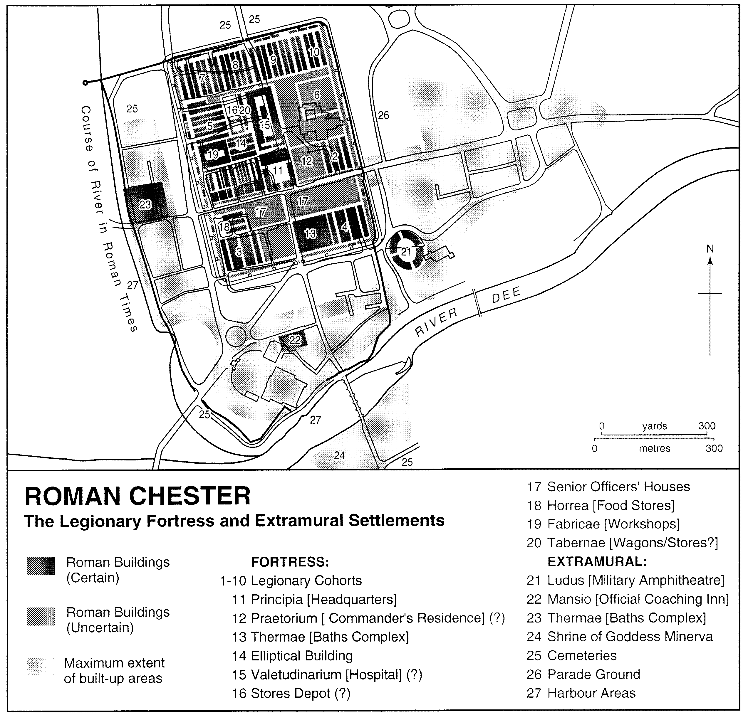
It was found on the Wirral at Meols (pronounced mells) by a local man digging for lugworms in 1955, in a peat layer 61cm (2ft) below the sand 274m (300 yards) off Dove Point. For those unfamiliar with the local geography, there’s a map at the end of the post. The flask was donated to the Grosvenor Museum in Chester. Although the location site consists of nothing but sand dunes today, it was formerly inhabited. Griffiths and his colleagues, in their 2007 monograph on Meols, describe the 19th century investigations of this strip of land:
The eroding sand-dunes not only produced an enormous body of small finds, but also
traces of buildings (the records of which are now unfortunately lost) and stumps of trees from the old ground surface. The numerous artefacts include, as well as many mundane objects, exotic pieces of high quality.
Today, the same team interpret early Meols (from the Norse meaning sand-hills) as a possible “beach market or port.”
Unsurprisingly, given the time that the pilgrim flask must have spent in the sand, the surface of the flask it is badly abraded and is slightly damaged. In the photograph on the left it looks as though it has a handle and spout, but in fact the “spout” was a twin handle, by which the vessel could be held in two hands, or threaded through a belt or chord for carrying. There is also some slight damage to the body of the vessel itself. It was not the most skilfully manufactured item, and was probably one of the less expensive examples on offer to the purchaser, but given its find-site is remarkably well preserved.
Although difficult to make out, the front of the vessel shows a scene consisting of the Roman-Egyptian St Menas flanked by two camels, about which more in a moment. There are photos of better preserved versions of the same scene below. I haven’t found a diagram or photograph of the reverse of the flask, but Griffiths et al describe it as follows: “The righthand part of the circular field has short radiating spokes from the frame. The design is very abraded and unclear, but appears to have a long curving design.”

Thompson’s figure 3, showing a sketch of the Meols flask at the time of its discovery. Source: Journal of the Chester Archaeological Society, volume 53, 1956
Material of the same period (6th-7th century AD) is found in the general area, confined to a short stretch at the top of the Wirral peninsula, producing over 100 artefacts, from both Roman and post-Roman objects, including Late Saxon and Anglo-Scandinavian material. Following its discovery in 1955 the find was reported very briefly by F.H. Thompson in the Miscellanea section of the Journal of the Chester Archaeological Society in 1956, accompanied by a sketch, and a description of the context in which it was found:
Although the coastal site of Meols, near Hoylake, is not now so prolific of antiquities as in the days when the Rev. A. Hume could devote a whole book to cataloguing the Romano-British, Saxon and mediaeval finds made there, single specimens are occasionally recovered.
The pilgrim flask is a well known form of vessel, and examples are found all over Egypt, and in Nubia. Fewer numbers have been found outside Egypt, most of them in the eastern Mediterranean. They are characterized by a lentoid (lens-shaped) body, narrow neck and twin handles, connecting the neck of the vessel to the main body. They seem to have been fitted with stoppers made from mud and other materials. The Meols example is 98mm high from lip to base. The body is 65mm wide, and the neck 35mmwide. The thickness of the pottery never exceeds 18mm. The neck and arms were added to the body after the manufacture of the vessel’s body, and there was not a great deal of skill demonstrated in its production. Much finer examples survive.

St Menas pilgrim flask from Preston on the Hill, Cheshire, now in Norton Priory Museum. Source: Griffiths et al 2007
The Meols pilgrim flask is not unique in England. Norton Priory Museum, near Warrington, has a collection of pilgrim tokens, one of which is a pilgrim flask from the shrine of St Menas, which was found in the Norton Priory area at Preston-on-the-Hill, shown left. It is missing its handles and neck. When the neck and handles are added on afterwards, the joints are a common point of failure. The Preston-on-the-Hill flask has a much clearer image of Menas and the camels and is framed with text, which is a blessing of St Menas. It was found during construction work for a new housing estate, and it is by no means clear how it got there. Other examples with a comparable date have been found elsewhere in England, including Durham, York, Derby, Baldock in Hertfordshire, Faversham and Canterbury. Although they are not unique, they are certainly not common. None, for example, have yet been found in Wales, Ireland or Scotland, although other contemporary Mediterranean objects have.
Who was St Menas?
St Menas was an early Christian saint dating to the Roman period who died in around the year 300AD. Christianity was introduced into Egypt, traditionally by St Mark, and became well established during the 2nd and early 3rd centuries in the multi-ethnic city of Alexandria on the Mediterranean coast. During the 541 Council of Chalcedon differences about theological understanding of the nature of Christ caused the Coptic Church of Egypt to split from Rome, and to establish its own clerical administration with its own pope, which it retains today. St Menas is part o the Coptic Christian tradition.

Pilgrim flask of St Menas at the British Museum, findspot unknown. BM1875,1012.16. Source: British Museum
There are a number of versions of the story of St Menas, and it is likely that the stories of St Menas and St Gordius were conflated into a single story. Probably the most popular version is that Menas was martyred in Phrygia, possibly during the reign of Diocletian in the 3rd Century for wishing to give up service in the Roman army to become a hermit in the service of God. Egypt had a tradition of eremitical worship in the desert, most famously represented by St Paul of Thebes (died c.345) and his follower St Antony (died c.356). The soldiers who killed Menas tried to burn his body but it remained unharmed. Pope Athanasius of Alexandria was visited by an angel who told him to take Menas into the desert for burial. Menas was carried on either one or two camels, and when the camel/s suddenly stopped and refused to go further, it was taken as a sign that he should be buried at the spot. A spring erupted into life where he was buried. The grave was forgotten until the 4th century. The story is that it was rediscovered by a shepherd when a wounded sheep submerged itself in the spring and was cured. As the shepherd continued to heal his sheep in the spring, the story began to spread. According to the legend Constantine the Great sent his daughter, afflicted with leprosy, to be cured. Her recovery endowed the site with even greater acclaim. Not long afterwards the saint’s grave was discovered, and a church was erected at the site in the Mareotis area, now known as Abu Mena, located around 45km southwest of Alexandria. The saint’s remains were transferred to the crypt. It soon became a place of pilgrimage with a settlement around it catering to the expanding number pilgrims from both inside Egypt and beyond as news of the shrine continued to spread. The site became renowned for its responsiveness to prayers, including the delivery of miraculous cures, becoming the largest pilgrimage destination in the eastern Mediterranean, and was considered to be a patron of desert caravans and merchants.
The Arab-Muslim Conquest of Egypt between 639-646AD caused considerable difficulty for the Coptic religion, and the site seems to have been destroyed at this time. It was partially restored in the 8th century but underwent various reversals and seems to have gone out of fashion after the 10th century. Excavations in the early 20th century, and then from the 1960s have uncovered the foundations of the church and the associated monastery.

Pyxis showing St Mena. British Museum 1879,1220.1. Source: British Museum
The saint was often shown on the pilgrim flasks flanked by camels wearing a short long-sleeved tunic, with a wide belt, military cloak, laced boots and raised arms in the “orans” posture, which is a gesture used by the clergy when praying with or on behalf of the congregation. The British Museum has a flask (shown above) that is much less eroded than the Meols example, and depicts the same scene of the saint flanked by two camels. It is more obviously similar to the Preston-on-the-Hill example, but lacks the inscription. Most have a different scene on the reverse side, sometimes another saint, but often a more geometric pattern consisting of motifs, as in the Meols example, .
Just for comparison, the ivory pyxis (cylindrical box) above left, dating to the 6th century, made in Egypt and found in Italy, shows a much clearer and far more elaborate version of the scene. On this side of the box St Menas is shown standing beneath an arch, representing a shrine, with his hands raised, flanked by two recumbent camels, and approached by worshippers. The reverse side shows his martyrdom.
What were the pilgrim flasks used for?

The ruins of the early religious complex at Abu Mena. It included, amongst other things, two churches, a basilica, courts, hostels, baths, a baptistry and colonnades. Photo source: Wikipedia
Above all the Egyptian pilgrim flask was a personal expression of pilgrimage for the purchaser, serving a) as means of carrying a part of the divine with him or her, b) as the memento of a personally important and perhaps very remarkable journey and c) as a mechanism for advertising that the pilgrimage was undertaken.
Pilgrimage is a personal voyage, for reasons known only to the person making the journey. Motivations can vary from an illness or disability afflicting the person making the pilgrimage, or afflicting someone else on whose behalf the pilgrimage is made, to a general need to demonstrate penitence, piety or fulfil another inner need. These little mementos contain more than hope – they contain something precious and beloved, a bridge between a person and his or her God, often via the intercession of a benevolent saint to whom it was perhaps easier to relate. Finds in Alexandria indicate that St Menas had a popular local following, and those further afield attest to his wider importance. A long distance pilgrimage was an investment not only of financial cost, time and energy, but also time away from family, home and the means of making an income, so it involved sacrifice, without which perhaps the pilgrimage was probably much less significant.
The similarity between the flasks, whether poorly- or well made indicates that they were mass-produced. They were not special to the producer, except as a means of making income, but they were immensely special to the pilgrim. Because the flasks were very small, between c.9 and 20cm tall, they were highly portable, and could be carried home even over very long distances without difficulty. Pilgrimage sites today still sell little objects for visitors to take home. Lourdes and Santiago de Compostella are two obvious examples, but at a visit to St Winifred’s well in Holywell, north Wales, I found that it too has a gift shop where you can purchase religiously-themed memorabilia.
Piers Baker-Bates of the Open University talks about the value of his own pilgrimage memento, helping to clarify the personal connection that people have with pilgrimage objects. This is part of the transcript from a short video, which at the time of writing you can find on the OU site here:
 This is the pilgrimage medal I had after I went to Santiago [de Compostela] in 1995. It’s just the ordinary cheap, lead model they sell in the tourist shops there, nothing special at all, but it was simply, if you like, my memento mori of the expedition.
It’s a scallop shell. The scallop shell has traditionally been the symbol of St James because it is a native of Galicia, which is the region of Spain where Santiago de Compostela is, and supposedly, according to legend, when his body was found it was surrounded by scallop shells, and this is therefore ever since been the symbol of the saint. So you will not just see the scallop as an individual symbol, but if you look at churches, if you look at hospices, if you look at other buildings connected with St James, they all have somewhere on them the scallop shell because it is the symbol of the saint.
If the chain wasn’t broken I’d still wear it round my neck all the time and it serves to remind me of something I did and I would like to do again eventually. If I was a medieval pilgrim, I’d have worn it in my hat, and you would have seen a wonderful selection of people who’d been to all the major shrines, who had a selection of these in their hats, so you’d have Jerusalem, Santiago de Compostela, Rome – they all had their own symbols. . .
Even though there are millions of these in the world, it still has meaning because it has meaning for me in particular, because it is particular to me, but also if someone else has one of their own, it will mean something to them. But at the same time, as a symbol, it means something to everyone, so when anyone looks at one of these they will recognise the symbol and understand what it means.
The vessel could contain the holy water of the well, the sand surrounding the shrine or liturgical oils. Some vessels were more elaborate than others. The Meols example, even though highly abraded, was probably never a very sophisticated piece of craftwork, meaning that the pilgrim who bought it probably had little spare money to spend. In Egypt, nearly all the complete examples were found in funerary contexts, indicating that they were sufficiently significant to the living that they wished to meet the afterlife with their pilgrim flasks at their sides.
Precursors of the the pilgrim flask

Clay vessel dating to the New Kingdom, painted with concentric rings, now in the Petrie Museum of Egyptian Archaeology (UC66492). Source: Petrie Museum of Egyptian Archaeology
The Coptic era pilgrim flasks were not an innovative form of pottery. The form emerged in the earlier New Kingdom (1550-1069BC). These were in their turn were based on vessels imported from the Levant in the 18th Dynasty (1550-1295BC). The form was soon taken up and copied by Egyptian potters who produced them for local demand. They were usually manufactured in clay, like the later pilgrim flasks, and sometimes other materials including glass, faience, stone and even metal. The early clay examples were frequently provided with a coloured slip and decoration that emulated the Near Eastern examples with concentric circles on each face. Kilroe suggests that the concentric circles were equivalent to branding, and that they were indicative of the contents of the flasks. They grew in popularity in the 19th Dynasty (1295-1186BC), and became part of the potter’s repertoire from that point forward. Their function was probably somewhat different from the later pilgrim flasks. One suggestion is that they were used for carrying valuable perfumed oils.

New Year flask from Egypt, now in the Walter’s Museum (48.419)
These were followed by so-called New Year’s flasks, which have the same basic shape, but with handles so small that they are merely decorative rather than functional. The New Year’s flasks are often ornate and are usually made of faience, an expensive material exclusive to the elite. New Year was one of the most important dates in the Egyptian calendar, marking the beginning of the Nile flood, which replenished the soil with fertile silts and saturated the land ready for germinating the seeds retained from the previous year’s harvest. Coinciding with the appearance in the night sky of the star Sirius, and closely associated with it, the new agricultural year was celebrated in an annual New Year festival called wep renpet meaning “opening of the year.” During the Saite 26th Dynasty (c.664-535BC) New Year flasks became a particularly popular celebratory item. They are found both in Egypt and abroad and are often decorated with papyrus and lily capitals. The lug handles on the shoulders are often in the form of the deity Thoth, represented as a baboon, responsible for knowledge, wisdom and the calculation of time. Nands of decoration around the body of the vessels and down the sides are also common. Many have hieroglyphs, often mentioning the wep renpet, together with favoured deities.
How did the Meols flask arrive in England?

Coins found in the northwest, including examples from the Wirral. Source: Philpott 2020, Journal of the Chester Archaeological Society, table V.1, p.53
F.H. Thompson discusses whether the Meols flask had been acquired at the St Menas shrine when it was brought to England or whether it was brought to the area at a much later date. There is no reason to doubt that it was manufactured in the 6th or 7th centuries, and there are arguments in favour of it having been brought to England at that time. As Thompson says, “finds of the late Saxon period from Meols are sufficiently common to suggest that this flask may well be contemporary.” The presence of three mid to late 6th century Byzantine coins in the Meols area are consistent with connections to the southeast Mediterranean at that time. This view is supported by William Anderson who believes that the flask may be associated with other evidence of long-distant contact, “namely amphorae and imported fine wares found at Tintagel in Cornwall, and other sites in Ireland, Wales, England and Scotland,” possibly representing direct trading contacts between the Mediterranean and and the west of Britain. Robert Philpott’s examination of early Byzantine coins from the northwest also supports a Mediterranean connection: “Although we lack diagnostic material to identify the elite with whom Mediterranean trade was conducted, the finds indicate an entry point at the port of Meols.” The Wirral coins, from Leasowe, Moreton,, Seacombe and Landican were issued over a period between 518 – 541 AD.
Susanne Bangert suggests two primary routes by which objects from Alexandria may have reached Britain. The first is an overland route across Europe, along the Rhine corridor or through Italy and via the Alps. Her other proposed route, by ship, would have passed through the Straits of Gibraltar and north up the Atlantic coast, putting into ports along the west cost of Britain, including Cornwall, Wales and perhaps Meols.

Beautiful photograph of Hilbre Island. Source: hilbreisland.info
It is a possibility that the pilgrim flask was connected with early Christian pilgrimage at Hilbre Island, just off the Wirral as part of a global pilgrimage circuit to Christian monasteries and shrines. As unlikely as this sounds, it is not beyond the bounds of probability, as some of the Egyptian pilgrim flasks in England are found in the rough vicinity of former monastic sites (Canterbury, Derby, Durham, Norton, Runcorn and York). Christianity arrived in England during the Roman occupation in the 4th century, after which it existed alongside pagan religions of the Anglo-Saxons until the arrival of Irish Christianity on the one hand, and the arrival of St Augustine’s mission to England from Rome in 597. Monasteries were established in both traditions, but many were destroyed by Viking raids during the 9th century. Only those of the Roman tradition were restored in the 10th century. Pilgrimage was a popular activity in Britain from the early Christian period until the end of the medieval period, and it is possible that the Meols flask was deposited or lost during a pilgrim’s visit to the tidal Hilbre Island. Although a monastic cell was established in the late 11th century by St Werburgh’s Benedictine Abbey in Chester, there was apparently a much earlier shrine to the obscure St Hildeberga, which the St Werburgh charters appear to confirm.

An example from Baldock, Herts., in the Letchworth Museum, no.7421. Source: Fitzpatrick-Matthews 2010
Another possibility is that although originally purchased at the Menas shrine, the Meols (and other English flask finds) were brought not directly from the site, but during near-contemporary or slightly later periods from Alexandria, locations in the Levant and elsewhere in the eastern Mediterranean, where many more Menas flasks have been found. A generation or two on from the original pilgrims who purchased them, they may have entered local markets as devotional curios, sold by their families to contemporary travellers to raise cash. Then too, at a much later date, it could have been acquired as an antiquity by a collector, or as a travel memento by someone on military service in the Near East, or making the Grand Tour. Philpott, in his analysis of coins from northwest England argues against this: “If the coins were modern losses by tourists or soldiers who served in eastern Europe, the Middle East or north Africa, as has often been asserted, the material recovered by metal detectorists should range more widely through the Byzantine era to embrace, for example, the common anonymous bronze issues of the late tenth to eleventh centuries, as well as other coins of Turkish, north African or Near Eastern origin.”
On balance, the available evidence seems to point a to a connection between the port of Meols and the eastern Mediterranean until the 7th century, and it seems likely that the Meols flask was introduced, along with other objects like the coins described by Philpott, at that time.
Final comments
There are four distinct phases that we know of in the life of the Meols pilgrim flask. The first is its production. Raw material sources were acquired, and the flask was manufactured. The raw material was clay, very easy to source in the Nile Delta, and the manufacturing process was mundane. Hundreds of pilgrim flasks have survived, and this is one of the less elaborate examples, produced quickly and without flourishes. The fact that the Menas pilgrim flask left the site of Abu Menas strongly suggests that it was purchased by a pilgrim, who bought one of the less expensive examples, and was probably not particularly well off.

The site of Abu Mena today. Source: Wikimedia Commons
Next, we find the pilgrim flask in Meols, so we know that it travelled. There are a number of possible explanations for how it left the eastern Mediterranean and arrived in Meols, all of them viable. Found in sand dunes, which cover the site of a small port, with a market, the object could have been hidden in a building that decayed, or may have been lost by its owner in or around the settlement.
The discovery of the flask in 1955, another stepping stone in its history, resulted in it being donated to its next port of call, the Grosvenor Museum, in 1956. The museum deemed it of sufficient curiosity value to have replicas made, which were sold in the museum’s shop.
Subsequently, a number of academic papers were written about it. Peter Carrington published a photograph of it in his book on Chester in 1994 (as mentioned at the beginning of this article, bringing us full circle), and it was described in some detail in a monograph about Meols in 2007. This little object has had quite an interesting life.
Although this is the story of an object, its real value lies in its part of a much bigger story – that of early Christian pilgrimage. When considered in the light of other pilgrim sites, and other objects that have travelled from the eastern Mediterranean to other parts of the world, it becomes much more than an object, and part of a fascinating narrative about people, movements and the way in which Christianity was understood and expressed in the 6th and early 7th centuries. The St Menas pilgrim flasks also offer the chance to explore the relationship between Christianity and Egypt’s pagan past, via the survival of some of PHaraonic Egypt’s ideas and traditions in object form. Finally, the presence of the pilgrim flask at Meols raises questions about the development of trade and transport on the Wirral and in Chester in the post-Roman period.
If anyone has anything to add to the story of the Meols pilgrim flask, do get in touch.
——-

The Wirral, showing Meols and Chester. Source: Google Maps
—-
Sources:
Books and papers:
Anderson, W. 2004. An archaeology of late antique pilgrim flasks. Anatolian Studies 54, p.79-93.
https://www.jstor.org/stable/3643040
Anderson, W. 2007. Menas flasks in the West: pilgrimage and trade at the end of antiquity. Ancient West and East 6, p.221-43
Bagnall, R.S. 2001. Archaeological Work on Hellenistic and Roman Egypt, 1995–2000. American Journal of Archaeology. Archaeological Institute of America, 105 (2), p.227–243
Bangert, S. 2007 Menas ampullae: a case study of long-distance contacts. In A. Harris (ed) Incipient Globalization? Long-distance contacts in the sixth century. British Archaeological Reports International Series 1644 / Reading Medieval Studies 32. p.27-33.
https://centaur.reading.ac.uk/84537/1/RMS-2006-04_S._Bangert,_Menas_ampullae,_a_case_study_of_long-distance_contacts.pdf
Bourriau, J. 2004. The beginning of amphora production in Egypt, in J. Bourriau and J. Phillips (eds.), Invention and Innovation. The Social Context of Technological Change 2. Egypt, the Aegean and the Near East, 1650-1150 BC, Oxford, 78-95
Brooks Hedstrom, D.L. 2019. Archaeology of Early Christianity in Egypt. In Pettegrew, D.K., Caraher, W.R. and Davis, T.D (eds). The Oxford Handbook of Early Christian Archaeology, Oxford Handbooks, Oxford Academic.
Carrington, P. 1994. Chester. Batsford / English Heritage (flask mentioned on page 54, and shown on page 56, figure 33)
Craggs, J.D. 1982. Hilbre: The Cheshire Island: Its History and Natural History. Liverpool University Press
Farmer, David. 2011 (5th edition, revised). The Oxford Dictionary of Saints. Oxford University Press.
Fitzpatrick-Matthews, K.J. 2016. Defining Fifth-century Ceramics in North Hertfordshire. Internet Archaeology, vol. 41.
https://intarch.ac.uk/journal/issue41/4/toc.html
Griffiths, D. and Bangert, S. 2007. Ceramic: The St Menas Ampulla. In Griffiths, D., Philpott, R.A. and Egan, G. 2007 (see below), p.58-9
Griffiths, D., Philpott, R.A. and Egan, G. 2007. Meols. The Archaeology of the North Wirral Coast. Discoveries and observations in the 19th and 20th centuries, with a catalogue of collections. Oxford University School of Archaeology Monograph 68, Institute of Archaeology, University of Oxford
https://archaeologydataservice.ac.uk/archiveDS/archiveDownload?t=arch-966-1/dissemination/pdf/Meols_text_2020_complete-lo.pdf
Grossmann, P. 1998. The Pilgrimage Center of Abû Mînâ. in D. Frankfurter (ed.), Pilgrimage & Holy Space in Late Antique Egypt. Leiden-Boston-Köln, Brill. p.282
Harris, A. 2003 Byzantium, Britain and the West: the archaeology of cultural identity AD 400-650. Tempus.
O’Ferrall, R.S.M. 1951. A Pilgrim’s Flask found in Derby. Journal of Derbyshire Archaeology and Natural History Society 71, p.78-9.
Philpott, R.A. 2020. Early Byzantine Copper Coins from Lowland North-West England. New Finds from Wirral, Cheshire and West Lancashire. Journal of the Chester Archaeological Society, volume 90, 2020, p.51-70
Richards, J.D., Naylor, J. and Holas-Clark, C. Anglo-Saxon Landscape and Economy: using portable antiquities to study Anglo-Saxon and Viking Age England. 4.4.5. Meols, Cheshire. Internet Archaeology
https://intarch.ac.uk/journal/issue25/2/4.4.35.html
Stevenson, A. 2015. The Petrie Museum of Egyptian Archaeology: Characters and Collections. Petrie Museum of Egyptian Archaeology, p.35
Thompson F.H. 1956. Pilgrim’s flask from Meols. Journal of the Chester Archaeological Society 43, p.48-9
Wyn Griffiths, D. 1991. Anglo-Saxon England and the Irish Sea Region AD 800 – 1100. An Archaeological Study of the Lower Dee and Mersey as a Border Area. A Thesis presented for the degree of Doctor of Philosophy. Department of Archaeology, the University of Durham
http://etheses.dur.ac.uk/1488/1/1488.pdf
Websites:
Gallorini, C. Innovating through Interactions: A Tale of Three Flasks.
https://www.researchgate.net/publication/260495223_Innovation_Through_Interactions_A_Tale_of_Three_’Pilgrim_Flasks’
Kilroe, L. 2014. Biography of an Egyptian Pilgrim Vessel. UCL 28th February 2014
UCL Culture Blog
https://bit.ly/3kBc65O
Medieval London. Ampulla
Fordham University
https://medievallondon.ace.fordham.edu/collections/show/90
St George Orthodox Ministry. The Coptic Pilgrims of the Wirral, 4th November 2020
http://www.stgeorgeministry.com/the-coptic-pilgrims-of-the-wirral/


.jpg)
.jpg)
.jpg)
.jpg)
.jpg)