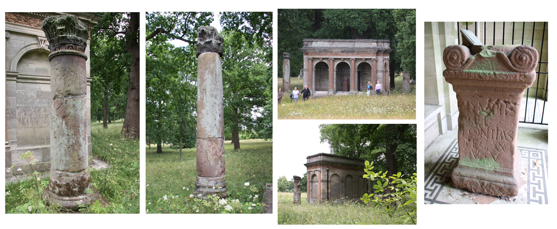
The building that houses the Roman altar at Eaton Hall
Eaton Hall is part of the Duke of Westminster’s estate 4.2miles / 6.7km to the south of Chester. It was very common for wealthy families to feature ancient Egyptian and Roman objects on their estates from the 18th century onwards. Many of these were imported from overseas, but the cobbled-together display of a Roman altar in a small custom-built structure, flanked by two columns, are thought to have come from no further afield than Boughton, on the eastern outskirts of Chester, Roman Deva.
The gardens are only open to the public for three days a year for charity, and tickets tend to sell out very quickly, so this is not the easiest of the local Roman monumental works to visit, although others are on display in the Grosvenor Museum in Chester.
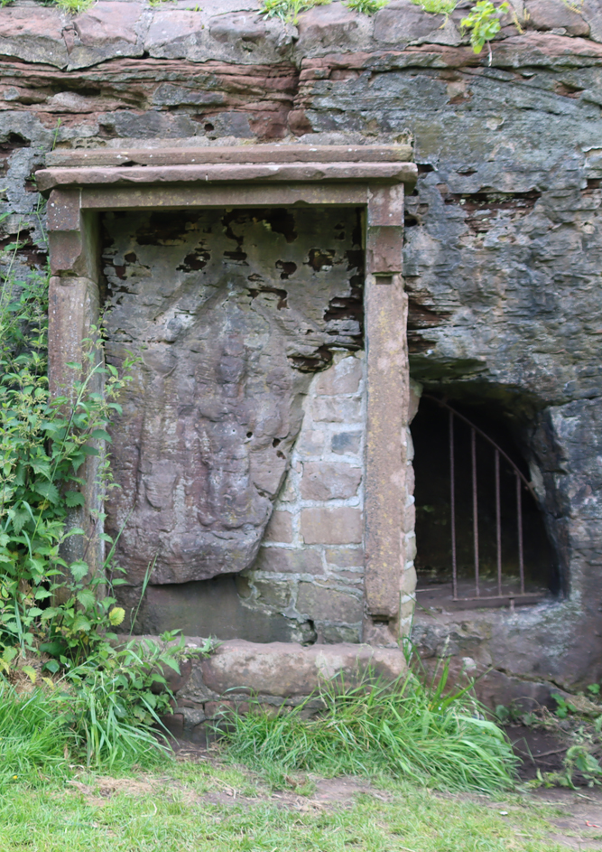
The Minerva shrine, Edgar’s Field, Handbridge, Chester
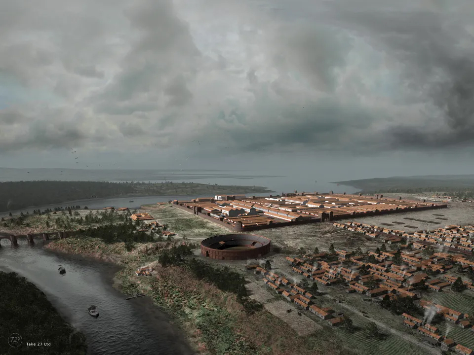
The Roman army had arrived in Chester, Deva, in around AD 74 and, with a requirement for a base on the Anglo-Welsh border area, settled on Chester as a suitable and obvious location. The river Dee had connections both south towards Wales and northeast via the Dee estuary to the sea, and was defensible. An earlier Iron Age settlement found during excavations at the Roman amphitheatre indicate that the Roman incomers were not the first to appreciate this location. The first fortress, built in around AD 76, was an earthen bank with a wooden palisade, gateways and interval towers, only being converted to stone from c.AD 100. As it grew, the new army base included the usual architectural and administrative collection of a headquarter building, officers’ accommodation, barracks, baths and storage, as well as the elite and unique ‘elliptical building’. Most of the stone for the new town was quarried locally from red sandstone bedrock, at least some of it derived from Edgar’s Field, on the south bank of the Dee at Handbridge, where a shrine to the goddess Minerva, protector of craftsmen, was carved directly into a red sandstone outcrop. Beyond the walls were a parade ground, the amphitheatre to its south and, eventually, a civilian settlement (canabae legionis), which inevitably grew up to take advantage of the new population.
It is probable that the altars and tombstones were made by indigenous craftsmen who came to these settlements to take advantage of the disposable income available from both the residents of the Roman town and their fellow settlers.
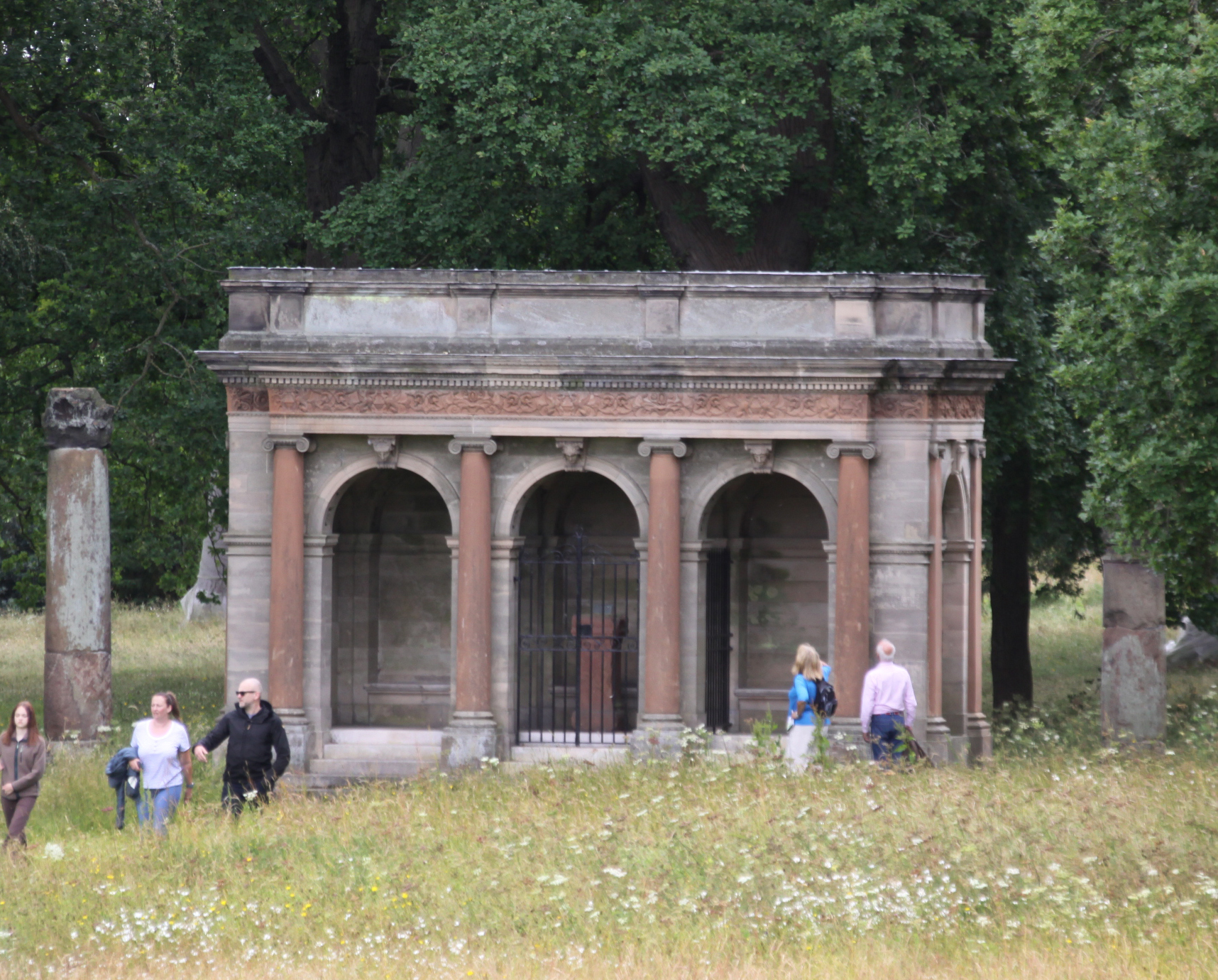
Julian Baum’s wonderfully evocative reconstruction of the fortress at Chester and the outer buildings in the mid 3rd Century, with the road leading away from the amphitheatre towards the bottom right, heading out east towards Boughton (copyright Julian Baum, used with permission)
Altars, demonstrating piety towards a particular deity or spirit, could be purchased by Roman citizens for personal worship, or could be donated to public areas. A specific request for help would be based on a deity’s particular skillset or virtues. Gods and spirits of place all had different characteristics and were associated with specific roles and functions. Sometimes altars were offered in hope of good fortune or as thanks, a form of obligation in return for a certain request being granted. Rituals accompanied by offerings took place at such altars to appeal to, appease, or thank a given deity. Such altars expressed a relationship between whoever erected the altar (a person, family or community), and the deity whose influence had been requested.
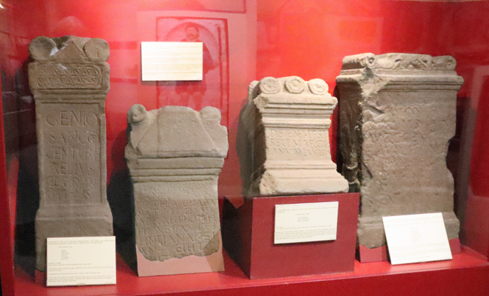
Inscriptions carved in Latin onto Chester altars and gravestones have provided considerable information about their owners and the wide range of places from where those owners originated, as well as providing insights about the deities that their purchasers had considered most relevant and helpful to their personal hopes and ambitions, both in life and the afterlife.
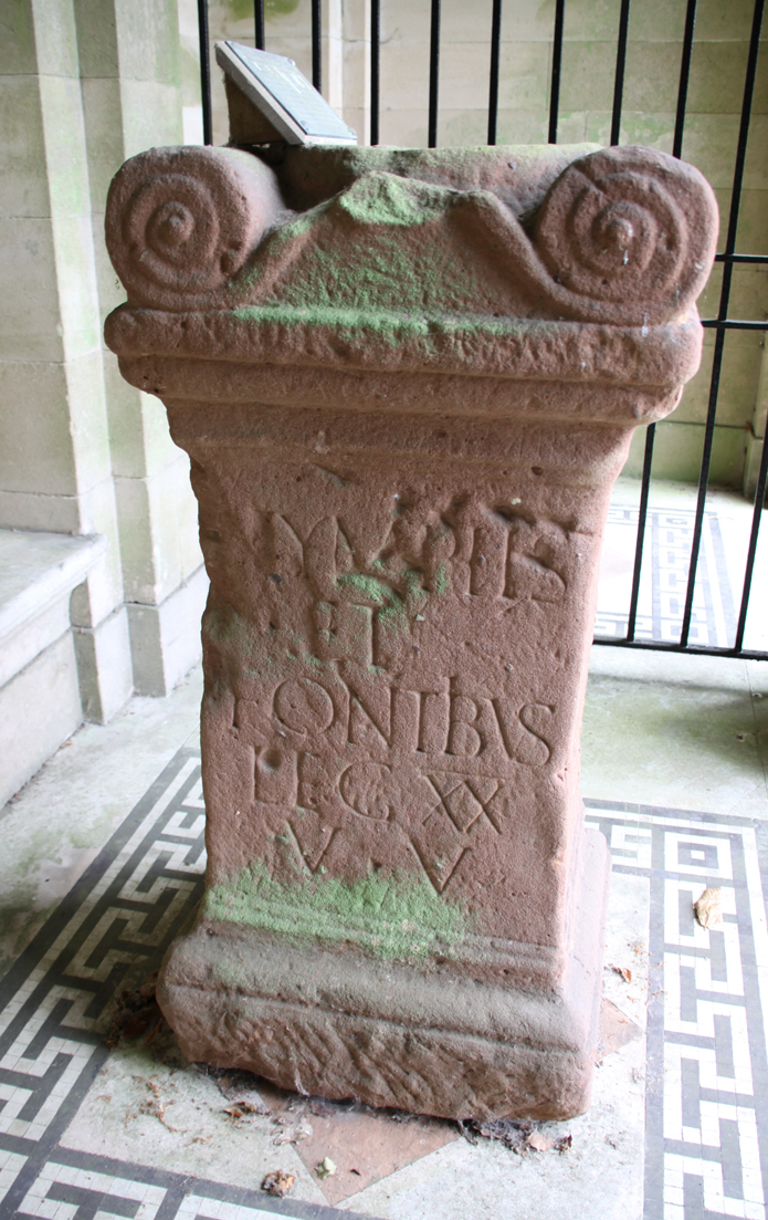
All known Roman inscriptions are recorded on the Roman Inscriptions of Britain website (https://romaninscriptionsofbritain.org/about/about-rib-online) itself based on the earlier printed volumes. The information about the altar in this short article comes from the Roman Inscriptions of Britain website. The official designation of the Boughton altar on the Roman Inscriptions of Britain website is RIB 460, and is classified as a “private possession.” The altar was found in 1821 in a field at the north end of what is now Cherry Road, near Boughton Cross, and about 1.8km east of The Cross, in Chester.
The altar is just under 120cm tall, 61cm wide and 50m deep. It is undated. There is an inscription on the front and back, but nothing on the sides. It stands on a pedestal, also original. The front is slightly damaged, but the front and back both read
Nymphis
et
Fontibus
leg(io) XX
V(aleria) V(ictrix)
The Roman translation, as provided by the Roman Inscriptions of Britain page reads: To the Nymphs and Fountains the Twentieth Legion Valeria Victrix. In other words, the Twentieth Legion Valeria Victrix set this up to the nymphs and fountains. It seems probable that the altar was built to commemorate guardians of the natural springs in the Boughton area, which probably supplied Deva with its water. The Romans had a particular affinity with natural springs, and often dedicated monuments to them. The best known in Britain is the dedication to Sulis-Minerva at the Roman baths in Bath, Sulis being the indigenous deity with whom the Roman Minerva was associated. The Eaton hall altar was not dedicated to a particular deity, simply venerating the more ephemeral but equally important and much-valued spirits of the place.
The springs in Boughton, 1.5km (1 mile) east of the city, which were fed by an aquifer sealed between two layers of boulder clay, were delivered to Chester by an aqueduct and pipes. One route entered Chester along the line of Foregate Street and the other ran to its south, feeding the cisterns for the bath-house boilers near the southeast corner of the fortress. David Mason estimates that in a 24 hour period, the military consumed some 2.370,000 litres (521,337 gallons) of water.
Roman altars at the Grosvenor Museum, Chester
The Boughton altar is now housed in a structure referred to as “the loggia,” located in an open grassy area lying between the formal gardens, and is roofed and open-fronted. It was presumably designed to loosely emulate a very small Roman temple. Two original Roman columns flank the loggia and, within it and protected from the outside world by railings, is a Roman altar made of red sandstone. The loggia protects the altar from the elements, and it appears to be in relatively good condition.
Although the Eaton Hall altar is not the easiest to visit, there are some excellent examples of both altars and gravestones in the Grosvenor Museum in Chester, which can be visited throughout the year.
Sources:
Books and Papers
Carrington, Peter 1994. The English Heritage Book of Chester. Batsford / English Heritage
Mason, David, J.P. 2001, 2007 (2nd edition). Roman Chester. City of the Eagles. Tempus Publishing
A recent Bluesky post by Nina Willburger (drnwillburger.bsky.social) about a 1st century AD Samian ware vessel found in Ladenburg, Germany, repaired in antiquity with lead rivets, reminded me of one of my favourite objects in the Grosvenor Museum in Chester.
Repaired Roman vessel from Chester in the Newgate Room in the Grosvenor Museum, Chester
It is always a good moment in a museum, especially a small local one, when one looks into a display cabinet and finds something completely unexpected. In the Grosvenor Museum in Chester, there is a high quality Samian bowl that was reconstructed in modern times with deliberately lighter pieces of matt clay added to make it perfectly clear what is old and what is new. What is more interesting is that this elegantly decorated bowl was originally repaired in the Roman period with lead rivets, and this really seizes the attention. It has no label, so there are no details about its date, provenance, history or subject matter, but it appears to show two hunting dogs facing towards each other with a stylized floral motif between them, with other stylized floral and animal forms circling the bowl beneath them. This is a common type of subject matter for Samian ware. Samian (terra sigillata) was the prestige table-ware of the Roman world. It was manufactured between the 1st and 3rd centuries, mainly in Gaul (today parts of France, Belgium and western Germany), and has a distinctive reddish-orange and glossy surface, with a very fine fabric texture. Although Samian could be undecorated, the most prestigious examples featured raised decoration, sometimes showing animal and floral motifs drawn from nature with more elaborate items representing gladiatorial events and simplified narratives drawn from Classical mythology.
Samian sherds from Silchester, a few of dozens rejected by Victorian excavators and thrown onto their spoil heap
Often all that is left of pottery at Roman sites are broken sherds that had been disposed of when a pot was broken. It is a fact of archaeological work that during excavations archaeologists are always in the position of finding the component parts of objects, the broken pieces that once made up a whole item. Today the majority of these are collected and weighed as a source of data about site usage, but in earlier periods of archaeological exploration, smaller and unremarkable sherds were often discarded. More remarkable sherds have always been privileged for collection and recording, as demonstrated by the pages from the excavation report of the Holt tileworks shown below. Where it is clear that sherds belonged to a single vessel attempts might be made to reconstruct the entire vessel, enabling the original appearance of an item to be understood by attempting to restore it to something resembling its original condition. Because of its inherent beauty and complexity, Samian pottery is often the recipient of modern reconstructions. Professor Robert Newstead (1859-1947), curator of the the Grosvenor Museum, was responsible for many of the museum’s reconstructions, using a lighter shade of clay to make it clear that modern repairs had been made.
Samian pottery found at the Chester tileworks at Holt. Source: Grimes 1930
Fascinatingly, in several parts of the world high value vessels were often repaired during antiquity, enabling broken items to continue in use, although perhaps for a new purpose. In recent years archaeologists and conservationists have shown considerable interest in preserving ancient repairs, recognising them as part of the life-history of an object, and an indication of how such objects were perceived and valued in the past.
In some parts of the world ancient repairs may date back to prehistoric periods. In around 4400-4000 BC, for example, repairs of bowls of Egyptian prehistoric Badarian ware, a very finely made ceramic belonging to nomadic sheep herders, were often achieved by drilling broken pieces to provide holes that could then bound together with cord, sinew or strips of leather. The Badarian pottery was some of the finest quality ware ever produced in Egypt, requiring considerable artistic flair and manufacturing skill, and was therefore certainly worth repairing.
A ceramic vessel may be broken in many ways at any point during its lifecycle from kiln, via transportation to purchase and usage and finally to breakage. As Angelika Kuettner (Chipstone Foundation) explains:
The Samian bowl in the Grosvenor Museum, clearly showing the lead rivets
Whether broken by shipment, cataclysmic weather event, a clumsy servant, a rowdy guest, unsupervised children or animals, or impassioned religious or political zealots, the owner of the ill-fated ceramic object then had to decide whether to repair the dish or dispose of it as waste, as something devalued to the point where it was completely worthless.
The reasons for repairing an item may depend on a number of variables, including such practical considerations as income and geography. Perhaps the owner of the bowl could not afford to purchase a replacement, or there was nowhere nearby to purchase anything similar at the particular time of its breakage. Perhaps the theme had particular significance and nothing equivalent was available locally. As well as practical reasons for a repair, there may have been sentimental reasons attached to a vessel, either because it was connected with a special person or event, perhaps because it was a gift or a family heirloom. It is even possible that the item was discarded by its owner when broken and retrieved by a servant in the household who took the opportunity to repair and own a luxury item. There is no way of knowing what motives were involved in this or any other ancient repair, each one having its own story. In this and other cases it is curious that the repair was so conspicuous, with no attempt at disguise, leading to the appearance of a luxury item being severely compromised.
Lead ingot from a river jetty site at the edge of Chester racecourse dating to 74AD. Source: David Mason’s “Roman Chester. The City of the Eagles,” p.45
The repaired pieces of Samian in the Grosvenor Museum were joined together using lead staples or rivets. As with the Badarian example shown above, the Samian repair technique required holes to be drilled into the object concerned before the rivet or staple could be applied. There is a video at the end that shows how this may have been achieved. Lead was used as a standard building material in Chester, for pipes and as waterproof lining for cisterns and reservoirs, and was mined from places like Halkyn mountain and Meliden near Flint, both in northeast Wales. David Mason estimates that 39 tons or 50 wagon-loads for water pipes, and 34 tons or 43 wagon-loads for reservoir linings were used during the building of Chester. Lead was readily available and would not have been difficult to source for the repair. Research has demonstrated that decorated platters, dishes and bowls are by the the most frequently repaired pieces of Samian in Britain, at both military and civil centres. Unsurprisingly, the number of repairs are highest in remote and upland areas
Bronze cauldron at the Grosvenor Museum
Another example of Roman repair work in the Grosvenor Museum is is a particularly nice bronze cauldron in the Newstead Gallery, shown right. According to the accompanying label, it was found in Chester’s Roman barracks by Professor Newstead, squashed almost flat, and was found to be made of a single sheet of bronze. Fascinatingly, it had been repaired 14 times during the period of its use, indicating how much it was valued. It was conserved and remounted by York Archaeological Trust in 2009, and looks stunning. As well as this story of ancient repairs this demonstrates a very imaginative and evocative approach to using the remaining parts discovered in an excavation to provide a very evocative reconstruction of the original form.
Repairs of favoured objects have continued to be made throughout history, still to be found sometimes centuries later in people’s homes. Stapling was common in the 19th century for the repair of valued ceramic items like the ornamental dish shown below. Cleverly, the rivets are clearly visible on the underside but do not actually pierce the main surface when turned over.
Repaired 19th century dish
A more extreme example is this piece of Kutani, obviously very much-loved by its owner judging from the number of rivets used to repair it.
The left hand image shows the multiple staples used in the repair of a Kutani cup, preserving the vessel so that the main design, right, can still be displayed. Photograph by Helen Anderson, with thanks
Interestingly, in spite of easy access to endless retail products at relatively low cost today, we often choose to repair items that we hold dear or which would cost too much to replace, rather than purchasing new versions. Ceramics are stapled or glued together, like the 19th century dish above, and the now international fashion for a technique called kintsugi (“golden joinery”) pioneered in Japan has given new life to broken objects by combining gold with an adhesive agent to provide a vessel with an entirely new life-force whilst retaining something of its original essence. This has become a skilled craft in its own right, and some kintsugi items now have a unique and precious value of their own. Having had a go at this with a lovely but broken dish that I found in my parents’ loft, I can attest to how much skill is required to produce something both beautiful and functional, skills that I apparently don’t have in any abundance 🙂
The Samian bowl in the Grosvenor Museum, showing both ancient repairs and modern repairs to allow reconstruction and provide a good sense of the original object
The repaired Samian bowl in the Grosvenor Museum, reveals both ancient repairs and modern reconstruction work. Both are part of its life history. There are just as many stories to be found in repaired items as in perfect ones, perhaps more. Although we are often accustomed to seeing only the brightest, best and most complete objects in museum collections, sometimes it is those that were broken and then repaired or otherwise curated by their owners that give us a personal sense of a connection with the past. Archaeology always includes unknowns, and there is never going to be an answer as to why this particular bowl was repaired, but it evokes a sense of the personal in a way that more perfect, undamaged objects in museum collections may not.
Vessels that had been repaired, whether lashed, stapled and/or glued would probably never be able to carry liquids without at least some leakage, but they could happily carry dried goods, continue to have decorative and sentimental and even prestige value and to be considered by their owners to retain a useful life.
Just as interesting as all the Samian items that have been repaired, is a single remarkable case of disposal from Vindolanda, which engagingly provides evidence of one of the biggest temper-tantrums recorded in British archaeology. The Vindolanda Charitable Trust website explains:
In our Museum at Vindolanda we have an almost complete dinner set of Samian Ware which was imported from the famous La Graufesenque potteries (near the modern French town of Millau at the southern end of the Gorges du Tarn). Using the potters stamps we have dated this collection to the late AD80s. The pottery had been broken in transit and was thrown, unused, into the ditch of the fort. . . . Imagine how disappointing it would be to finally get your delivery only for it to be broken!
It puts breakages received from Amazon into perspective. xxx
Professor Newstead and some of his restored Samian items, in the Newstead Gallery of the Grosvenor Museum.
At the end of the post see a nice video by Guy de la Bédoyère who, amongst other things, discusses the variable quality of Samian found in Britain and elsewhere; and another one that shows how, in the Roman period, mending holes may have been made in Samian using a manual drill that uses a simple but effective technology deriving from the use of spindle whorls.
Sources:
Books and papers
Albert, Kasi 2012. Ceramic rivet repair: History, technology, and conservation approaches. Studies in Conservation, 57(sup1), S1–S8.
Hsieh, Julia 2016. The Practice of Repairing Vessels in Ancient Egypt. Methods of Repair and Anthropological Implications. Near Eastern Archaeology, Vol. 79, No. 4 (December 2016), pp. 280-283
Dooijes, Renske and Olivier Nieuwenhuyse 2007. Ancient Repairs: Techniques and Social Meaning. In (eds): M. Benz and U. Kästner (red.), Konservieren oder restaurieren, die Restaurierung griechischer Vasen von der Antike bis heute (3rd suppl. to the CVA Germany), Beck Publishers, 15-20 https://www.academia.edu/13881341/Ancient_repairs_techniques_and_social_meaning
Gosden, Chris and Yvonne Marshall 1999. The Cultural Biography of Objects. World Archaeology 31(2), October 1999, p.169-178
Grimes, W.F. 1930. Holt, Denbighshire: Twentieth Legion at Castle Lyons. Y Cymmrodor. Society of Cymmrodorion.
Kopytoff, Igor 1986. The cultural biography of things: commoditization as process. In (ed.) Arjun Appadurai. The Social Life of Things. Commodities in cultural perspective. Cambridge University Press
Mason, David J.P. 2001, 2007. Roman Chester. The City of the Eagles. Tempus Publishing
The new Gladiators of Britain exhibition at the Grosvenor Museum fits the archaeology of a huge story very cleverly into a relatively small space, with a great many remarkable objects that have been very well chosen to illustrate the topic.
Thanks to Chester Archaeological Society I was lucky enough to be one of a group who were invited to a guided preview of the exhibition in late September 2025, just as it was opening. Many thanks to Pauline Clarke (Excursions Officer at Chester Archaeological Society) and Elizabeth Montgomery (Grosvenor Museum) for organizing our visit. Liz took us around the exhibit in two groups, and explained how the original exhibition had been organized by Glynn Davis, Senior Collections & Learning Curator from Colchester and Ipswich Museums, who had arranged for the loan of objects from both Chester’s Grosvenor Museum and London’s British Museum, partly to contextualize the remarkable and substantially important find of the Colchester Vase, shown both in the above poster and in photographs below. When this exhibition had closed, the various parties who had contributed to the Colchester exhibition were approached with a view to loaning the same objects to enable a travelling exhibition, which is what we see at the Grosvenor today, using objects and interpretation boards to introduce gladiatorial contests in Britain. xxx
The Chester Amphitheatre
Before talking about the exhibition I though that it might be useful to put it into the context of the Chester amphitheatre. For those completely happy with the history of the Chester amphitheatre, what amphitheatres were for and the roles they performed, do skip ahead.
Rome’s Colosseum, which opened in AD 80, shown on a sestertius coin, on display at the Gladiators of Britain exhibition
Gladiatorial conquests took place in amphitheatres. The best known amphitheatre in Europe is Rome’s own stone-built Colosseum, which remains even today a stunning piece of architectural ambition, remarkably preserved and awe-inspiringly vast. The exhibition has a video running on a small tablet that shows a super 3-D reconstructionof what the Colosseum may have looked like in the past (by Aleksander Ilic). It provides a sense not only of an amphitheatre’s structural components but also of its monumental grandeur, reflecting its importance to Roman ideas of the necessities of urban infrastructure and social identity.
Like all other Roman military centres and towns, Chester (Roman Deva), established c.AD 74/75 was provided with an amphitheatre, currently the largest known in Britain. As the museum curator, Elizabeth Montgomery, made clear when guiding us around the exhibit, that statement comes with the caveat that at the important northern centre of York (Eboracum) the amphitheatre has not yet been located, but the scale of the Chester amphitheatre is a very impressive feather in Deva’s cap. Located just beyond the southeast corner of the fortification, just beyond the city walls and the New Gate (formerly the Wolf Gate) on Little St John’s Street.
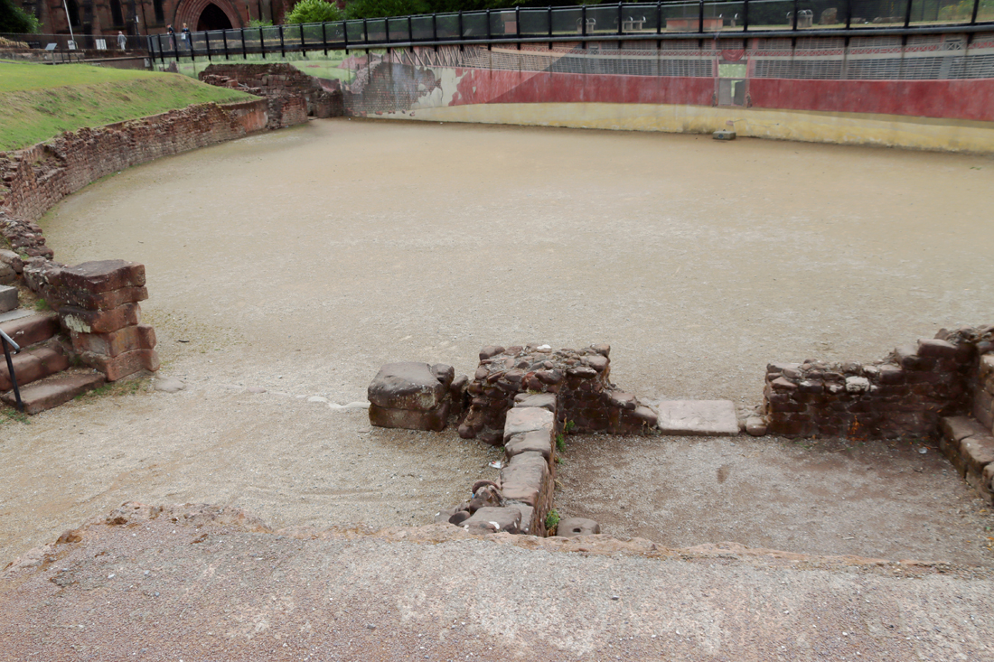
The Chester amphitheatre as it is today, showing the small room that housed the shrine to Nemesis at bottom right
Britain was attractive to Rome as a target for invasion partly because, at the edge of the known world, it was an quick win for both Julius Caesar and then Claudius. It was far more prestigious to expand the Empire to its geographical limit than to merely curate its existing holdings. It is clear too that by the first century AD the Romans stationed on the Rhine had begun to become materially aware of Britain via her trading relationship with Gaul, benefitting from her produce, raising an awareness of her resources, and providing a strong secondary reason both for the Claudian invasion and for sustained occupation. Although Britain remained a peripheral province in a world where Rome was the centre of the geographical and cultural universe, the province had successive governors who were responsible for maintaining Britain as a component part of the Empire, with most of the infrastructure to mark it out as Roman territory. Every major fortress and town boasted an amphitheatre and Chester had one from shortly after the establishment of the legionary fortress in the first century AD.
A wall map from the exhibition showing the location of 17 known amphitheatre or amphitheatre-like structures in Britain
An amphitheatre such as the one we have in Chester was multi-functional. Although usually exclusively associated in people’s mind with spectacular and often gory action, where trained gladiators fought both other humans and wild animals, it was also used to execute criminals, to host military displays, to offer less lethal forms of entertainment and to display religious ceremonies and rituals. It also doubled up as an additional training space for the military, only a very short march from the parade ground that was on today’s Frodsham Street, where training and drilling, manoeuvres and tactics, to prepare soldiers for the realities of military engagement against a potentially fractious population; and at the same time kept large numbers of men sufficiently busy to minimize the disputes that might break out.
Because many of the activities, particularly the gladiatorial events, attracted large audiences (in their 1000s), they had in common with football stadiums that they were designed to accommodate a large number of spectators, funnelling them via staircases and ramps to the raked seating, providing them with ease of access and clear visibility of the spectacle that unfolded below, a major task of civil engineering based on an understanding of crowd control. The large number of entrances at the Chester amphitheatre is indicative of this understanding of how people flowed into a central location.
Gladiatorial event shown on a 2nd century slate found in Chester, on display at the exhibition
Sadly, although the Chester amphitheatre may have been used following the abandonment of Britain in AD 410 as a local defensive enclosure, the amphitheatre’s vast walls were subsequently robbed for building materials so thoroughly that it was reduced to it to nothing more than its foundations and the arena floor. This denuded space was subsequently used as a dump, slowly filling in, and eventually becoming completely covered over and forgotten. Buildings and gardens obliterated all evidence, with only Little St John’s Street, bending in a puzzling way, following the old line of the amphitheatre walls. Perhaps the first hint that an amphitheatre may have been part of the Roman footprint of Chester was a slate plaque found in 1738 that showed a gladiatorial scene.
The Chester amphitheatre was rediscovered in 1929 when a new extension to the the Georgian and Victorian Dee House Ursuline Convent School, still sitting over the southern part of the amphitheatre, (and now known simply as Dee House), required a new basement for heating equipment, and the works that followed encountered Roman remains. These were quickly recognised by W.J. Williams of the Chester Archaeological Society, who knew of the slate plaque, and shortly afterwards trial trenches were excavated by the Grosvenor Professor Robert Newstead of the Grosvenor Museum and Professor J.P. Droop, confirming that this was indeed the Roman city’s amphitheatre.
Detail of John McGahey’s 1852 painting of Chester from an air balloon (with my rough indicator of location of amphitheatre in red show how completely the amphitheatre area was covered over). Source: Ainsworth and Wilmott 2005 / Chester City Council
The site was already under threat from a new road, preparatory work for which had already taken place to run it across the centre of what was now known to be the amphitheatre. The public and heritage organizations instantly responded, and different sources of pressure caused the plan to be cancelled. Chester Archaeological Society (C.A.S.) took the lead in raising funds to clear the site and enable access for further excavations. Although these plans were interrupted by the Second World War (during which air raid shelters were dug into the amphitheatre, destroying archaeological material), these excavations took place in the 1960s, lead by F. Hugh Thompson, who proposed a phased build for the amphitheatre. In the 1990s a proposal to develop the site as a heritage destination led to planning permission for the Grade II listed Dee House to be knocked down to enable the excavation of the land beneath, but this met with financial problems, the plans faded and the planning permission lapsed in 1995 (a real lost opportunity). In 2000 the site was again excavated, this time by Keith Matthews of Chester Archaeology, who revealed more data and came to different conclusions about the phasing the amphitheatre.
In January 2003 Chester City Council joined forces with English Heritage to initiate the Chester Amphitheatre Project, covering both the amphitheatre and flanking areas. Objectives included non-invasive survey, excavation where appropriate and publication of the findings. The work took place between 2004 and 2007, led by Dan Garner (Chester City Council) and Tony Wilmott (English Heritage). The survey and excavations between 2005-2006 led by Tony Wilmott and Dan Garner, published in 2018, were particularly informative. The presence of the listed building Dee House on the other side of the site, although derelict, has prevented any further progress being made.
Phasing of the amphitheatre shown in blue (first amphitheatre) and orange (second amphitheatre). Source: Ainsworth and Wilmott 2005, p.23
The outcome of all this work has been a narrative of the large oval (rather than elliptical) amphitheatre’s two-phase construction. The first phase was erected early in the fortress’s history probably shortly after the establishment of the legionary fortress after AD 74/75. The early date of the amphitheatre at around AD80 is not unusual, with other early examples known from, for example, Dorchester, Silchester, Cirencester and Caerleon. The second amphitheatre has destroyed some of the evidence of the first. The first amphitheatre was built in more than one phase, but it appears to have matured as a wooden scaffold holding seating, with a wall at its back, and another wall separating the seating from the arena. The access to upper levels was via an external staircase, an arrangement that is otherwise only known from Pompeii at a similar date. An interesting feature of the early amphitheatre phase is a small painted shrine dedicated to the deity Nemesis, which was retained in the second amphitheatre.
The second main phase of amphitheatre construction resulted in Britain’s biggest example of this type of building. A new outer wall was built following the line of the earlier amphitheatre, a vast 2m (6ft 7ins) thick and 1.8m (5ft 11in) outside the outer wall of the first structure. The original four entrances identified in the first amphitheatre were retained but new entrances were added that lead to the interior (vomitoria) to allow access to upper seating, suggsting that the outer wall was much higher than the earlier amphitheatre, an impression that is reinforced by the sheer size of the new outer wall. As Willmot and Garner say (2018) “its size; the number, complexity and organization of entrances and the treatment of the exterior facade all place it in an architectural class beyond that of the other amphitheatres in the province.” It is estimated that the new amphitheatre could have accommodated up to between 7500-8000 spectators. It is to this phase that the tethering stone belongs, as well as a coping stone (rounded stone topping for a wall) that contains the inscription “SERANO LOCUS” (see photo of both at the end of the post).
Julian Baum’s incredibly life-like reconstruction of Roman Chester, showing the dominance of the amphitheatre, with the parade ground to its north. See more details of the amphitheatre on Julian Baum’s site at https://jbt27.artstation.com/projects/bKDayr?album_id=332464 Copyright Julian Baum, used with kind permission (click to expand)
As well as being essentially a part of the urban townscape, albeit excluded from the fortress, the tall, impressive structure that would have made an impression far beyond the immediate environs of the city. The surrounding landscape would have been in no doubt that the Ro mans had arrived, settled, and were here to stay, their amphitheatre not unlike a medieval cathedral in its powerful messaging. This is abundantly clear in Julian Baum’s reconstructions, such as the one here, demonstrating how the amphitheatre could act as a symbol of Roman presence, sophistication and power. Another of Julian’s reconstructions, showing the city at sunset, is on display in the exhibition, and both clearly demonstrate how dominant a feature the amphitheatre must have been and how important it was to the inhabitants of the fortress. xxx
The Gladiators of Britain Exhibition
As there are no written records of the events that took place in Britain’s amphitheatres, the focus of the exhibition is on archaeological data and its interpretation. There are some very short inscriptions in stone that hint at the importance of the gladiatorial events, but the bulk of the data that informs ideas of what remains are the amphitheatres of Britain themselves, and the objects that record the spectacles that people attended. The exhibition has brought together some very evocative pieces. All the photos below are from the exhibition.
The exhibition does not attempt to analyse the Chester amphitheatre and nor does it set out to answer the bigger questions about how gladiators were trained, where they came from, or how they were deployed. What it does superbly well is demonstrate how the gladiatorial spectacle was captured both in massive architectural endeavour and in material remains preserved in the archaeological record.
The Colchester Vase
The exhibition opens with some details about the amphitheatres in which gladiatorial confrontations took place. Not only is there a video by Alexander Illci showing a reconstruction of Rome’s magnificent Colosseum, but there is a fabulous, splendidly detailed coin showing the amphitheatre in raised relief, dating from AD 80. The exhibition then goes on to explore the world of gladiators via specially chosen objects that reflect the impact how amphitheatres and gladiators contributed to o Roman urban life, even far from the heartland of the Roman Empire.
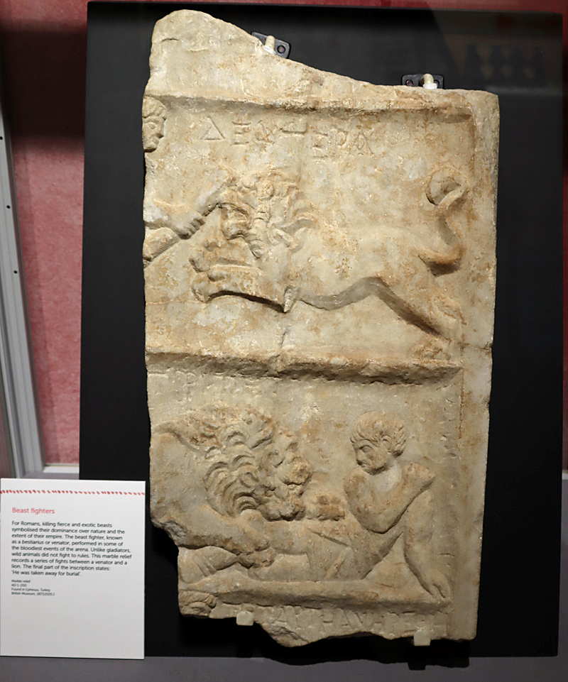
The Colchester Vase, being perhaps the key object that inspired the exhibition, is worth taking time over when you visit. Apart from the fact that it is superbly well crafted, a piece of real excellence, it tells more than one story, with each component moulded in high relief. To ensure that the vessel can be appreciated in its entirety, a mirror has been placed behind it, and the lighting highlights the relief figures very clearly. It shows a gladiator versus another gladiator, a gladiator versus a beast, and beasts chasing beasts.
Gladiatorial Helmet from Hawkedon, Suffolk
Another key object in the exhibition is the helmet from Hawkedon in Suffolk, one of the most important objects to be found in connection with the history of gladiators in Britain. Unlike the Colchester Vase, or any of the other objects depicting gladiatorial action discussed below, this was design to participate in the action, worn to protect the gladiator and give him the best chance of survival. The frontpiece is modern, added to give a complete impression of what the original item looked like. Analysis of the metal suggests that it was made on the continent and hints that both it and perhaps its owenr may have travelled to Britain for participation in the amphtheatre.
Amongst many other discoveries during the excavations , the one that confirms that gladiatorial bouts undoubtedly took place in the Chester amphitheatre was a huge sandstone tethering stone, which tied animals and some human contestants alike to a central point to prevent them seeking refuge at the sidelines where they could not be viewed by the full circle of spectators (shown at the end of the post). This somewhat daunting object is on display in the exhibition. Although by far the crudest of the many lovely objects on view, it is the one that moves the exhibition from art-works to action, forcing the visitor to engage with the the very savage and bloody nature of the contests. It is one thing to look at a pretty scene on a vase or stone; it is quite another to be confronted with the block that physically chained the victim to its unavoidable fate.
Second century pottery lamp from Italy in the Gladiators of Britain exhibition
Although the gladiators were the stars of the events, the members of the audience were just as important for the success and ambience of the amphitheatres, and many of the other objects in the exhibition reflect the sense of involvement and enjoyment that individuals took from amphitheatre events. One item that clearly demonstrates this sense of involvement is A coping stone, inscribed SERANO LOCUS (shown at the very end of this post), may have been part of the arena wall, perhaps marking the place (“locus”) of a spectator named Seranus. Although the more remarkable of the items in the exhibition, such as the Colchester Vase, were probably specially commissioned, other items are far less prestigious. The many oil lamps in the exhibition, showing scenes of gladiators in action, were probably purchased like souvenirs when peformances were taking place. It is thought that traces of outer buildings and the remains of food items at Chester represent snack stalls, and it is entirely likely that souvenirs could also have been sold in the same vicinity, or after the event in marketplaces.
Altar dedicated to Nemesis by Sextius Marcianus, found in a shrine at the amphitheatre.
Also on display is the shrine to the goddess Nemesis, apparently retained in the second amphitheatre after being built for the first one, adds a religious dimension to proceedings, a feature known from other amphitheatres in the Empire as well. Representing fate, Nemesis was appropriate to the prospective fortunes of both winner and loser. Nemesis was particularly appropriate for a gladiatorial outlook, whether winner or loser, representing fate. It was dedicated by the centurion Sextius Marcianus who had it made after experiencing a vision.
There are a great many more objects in the exhibition. Each has been well chosen to show different aspects of the gladiatorial experience, and each is well explained in the labelling. A wide variety of materials are represented, including stone, metals, wood and pottery, and many are decorated with great imagination. Some were component parts of the amphitheatres themselves. Others were items used in the arena, whilst a wide range of items were designed for the home. Most of these were the objects that people chose to commission or purchase, took into their homes and cared for, maintaining them in beautiful condition. As the exhibition demostrates so clearly, when they were buried, broken or lost in transit, they became archaeological remnants, and in doing so became threads of several different lines of investigation that continue to feed into broader research about the Roman occupation of Britain.
As well as the objects themselves, the information labels and interpretation boards not only inform, but create an all-encompassing experience that helps visitors to get to grips with a fascinating if gory subject matter. The interpretation boards are beautifully designed, giving the exhibition a good sense of coherence. Fortunately there is no gore on show, so this is entirely child-friendly (with games and dress-up outfits available for children) and whilst the exhibition does not judge, it leaves visitors in little doubt that this was a form of entertainment that potentially had a life or death outcome, whether for human or animal.
The exhibition may be small but it makes a terrific impact, making superb use of the space available, and seeking at every turn to inform and involve. The art work on the interpretation boards is attractive, and there is a lightness of touch to the whole presentation and the delicate artwork that manages to complement rather than overwhelm the exhibits and the themes. It is really well done. Don’t miss it!
With many thanks to the Grosvenor Museum’s Liz Montgomery for a really engaging guided tour of the exhibition.
The exhibition is free of charge to enter, and the museum opening times are shown on its website: https://grosvenormuseum.westcheshiremuseums.co.uk/visit-us/. Do note, as shown above, that group tours are available on Mondays, and you can phone up to arrange them. The exhibition is on in Chester until January 25th 2026.
Enjoy!
For anyone wanting to gain an impression of what the Chester amphitheatre may have looked like, the following YouTube video by 3-D modeller Julian Baum in collaboration with archaeologist Tony Willmot may help to visualize the building:
Sources and further reading:
Books and Papers
Hunt cup from Colchester
Ainsworth, Stewart and Tony Wilmott 2005. Chester Amphitheatre. From Gladiators to Gardens. Chester City Council and English Heritage
de la Bédoyère, Guy 2001. The Buildings of Roman Britain. Tempus
de la Bédoyère, Guy 2013. Roman Britain: A New History. Thames and Hudson
Carrington, Peter1994. Chester. B.T. Batsford / English Heritage
Wilmott, Tony and Dan Garner 2018. The Roman Amphitheatre of Chester. Volume 1, The Prehistoric and Roman Archaeology. Oxbow (also available on Kindle, although not all of the tables are fully legible)
Based in Churton Peter Carrington’s excellent guided walk of Roman Chester during the Festival of Ideas. Andie Byrnes, July 6th 2025 https://wp.me/pcZwQK-7OD
Many thanks to professional visual effects and 3-D graphics modeller and independent researcher Julian Baum for a really fascinating presentation about new research into the River Dee.
One of Julian Baum’s beautiful reconstructions of Deva and its outer buildings in the mid 3rd Century, based on data from archaeological excavations, showing the Roman town in the context of the river and the widening estuary beyond.
The talk focused on how the Dee’s formation, archaeology and several historic maps have raised a number of questions about the Roman river. Julian made it very clear that the presentation would consist of a number of hypothetical scenarios based on observable features, none of which can yet be fully supported by the available data. He and his fellow investigators Rod Hobbs and Peter France have been compiling their data for the last six years, and have produced a 17,000 word paper that has been sent out to experts on Roman stonework and hydraulic engineering for consideration. As they continue to assemble responses to their proposals, the team are also looking for opportunities to work with other specialists to extract more data from the field. So, accepting that these ideas need more data to test the hypotheses presented today, what are the questions being asked?
The presentation followed the formation of a new research group, which met in June for the first time and included specialists in a number of relevant fields. A great many questions were asked at that meeting, but the two overarching research questions are as follows:
1) What do we know about the geology and geomorphology of the Dee valley in the Chester area? Although multiple glaciations impacted the underlying geology of Britain, it was the impact of the last glaciation that is of most interest for the second question.
2) What do we know about Chester and the nearby archaeology, from the prehistoric to early Medieval periods, with particular focus, initially, on the Roman period?
Julian Baum’s presentation then went on to introduce the geology and glacial history of the Dee valley before going on to describe three key archaeological questions.
The Chester weir
First, how old is Chester’s remarkable weir? Traditionally it has been dated to the Norman period when the notorious Hugh d’Avranches, better known as Hugh Lupus, began to introduce substantial architectural and civil engineering works to develop a strong economic, religious and social foundation for Chester. There can be no doubt that Hugh Lupus undertook works on the weir. What is less certain is if he was the first to establish a weir here. The proposal by Julian Baum, Rod Hobbs and Peter France, just an intriguing theory at this stage, is that the weir may have been a Roman innovation, mirroring hydraulic works elsewhere in the empire, required to raise the level of the river upstream to enable the vast barges carrying essential building materials from Holt. The initial round of research described in the presentation has produced considerable quantities of data about the river bed, about post-glacial sea levels and tidal information, as well as looking at all the available archaeological data published to date. Divers have been consulted and the river boat captains have provided invaluable information about their own experiences with the river depth today, as well as seasonal variations in the navigability of the river. As the presentation emphasized, much more research is required to test this proposal. An academic paper has been written by the three researchers and is currently being circulated amongst specialist in the field, who have all expressed an interest in assessing the hypothesis.
The Braun map of 1571
The second question concerns two 16th century maps of the Roodee that show that the north western edge was an almost straight line. How can this straight line be explained? Building on earlier archaeological discoveries the same researchers propose that this edge may have marked the position of a very long Roman timber jetty. The line of wall usually identified as the old Roman quay near the modern HQ building at the east of the Roodee has been widely discredited, so the question of where the Roman quay was located remains open. This proposal makes a great deal of sense, but it too needs testing, and Julian Baum proposed a number of ways in which this could be done using specialist equipment and taking advantage of the upcoming building works at the Roodee. An interesting corollary to the proposal is that if there was indeed a jetty there, supported on presumably vast timbers, and of a width to enable wheeled vehicles and horses to reach ships moored up along its length, its collapse would have created a major disruption to river flow, and could have had a considerable impact on the silting of the river.
Chester amphitheatre
The third question concerns the archaeology of Chester and its environs prior to the arrival of the Romans. Iron Age remains were found during the amphitheatre excavations of the 1980s, and there are other indications that there was a healthy Iron Age presence in the area before (and when) the Romans arrived. This data needs to be collated before it can be assessed, and this is another aim of the research group.
All findings will be made available online on a dedicated website that is currently being built. The website address will be made available as soon as it is launched.
With many thanks to Julian Baum and other team members, who were present on the day, for such a fascinating presentation.
Dr Peter Carrington, an experienced archaeologist specializing in Roman history, author of the English Heritage book Chester, and editor of the Journal of the Chester Archaeological Society always heads a guided walk as part of the city’s two annual festivals. This year he introduced a large group of us to what remains of Roman Deva. We had all received an introductory handout beforehand by email, which as well as outlining the history of the city, included maps and images of aspects of Roman Chester that could only be represented visually. We met up at the canal bridge just outside the Northgate, so that we could look back towards the stretch of city wall that extends east, high above the bedrock channel that contains the 18th century canal.
Here, just on the other side of the bridge over the canal, a line of Roman wall is still clearly visible, originally topped by an ornamental cornice, the remains of which still survive, bizarrely incorporated into the later walls. It is thought that the wall originally stood to around 15ft (c.4.5m). It was news to me that the original defences had been turf-built, and that single layers of stone walling, leaning up against the turf wall, were subject to subsidence and patches of collapse. The inward-leaning profile of that surviving section above the canal may be explained by that process of subsidence, and this is probably responsible for much of the rebuilding necessary around the walls. We went up on to the walls and as we proceeded clockwise towards the cathedral, looking over the edge at key points along the way, some of the complexity of the original Roman design was explained.
Walks around the walls are always popular with tourists and residents alike, but sometimes it is what we can see at the base of the walls that tell us most about the Roman past. When we left the walkway along the top of the walls to examine sections of Roman wall at the foot of the later walls, in Northgate gardens and the Kaleyard and opposite the amphitheatre we learned about the difference between the massive, uncompromising blocks of Roman stonework and the later medieval and Victorian sections of much smaller, sometimes rounded stonework.
The amphitheatre itself is one of Chester’s most well-known tourist attractions but because nearly half of it remains buried under a hideously decaying eyesore of a building, part of which is Georgian and all of which has been abandoned (shocking tourists), the story is only partially told. Even so, two sets of excavations have revealed an enormous amount of details about the chronological history of the site, which was the biggest Roman amphitheatre built in Britain, with clearly visible phases of enlargement preserved in what remains today. Peter talked us through the different phases, and explained how the interior would have looked and how the timber sections of seating would have been built and arranged, painting a verbal picture of a much more elaborate building than we see today. As Peter pointed out throughout the walk, understanding the vertical past of Chester is far more challenging than getting to grips with its horizontal footprint. It is hoped that the report on the post-Roman history of the site, also of profound interest, will be published in the upcoming months.
The Roman Gardens, which connect the amphitheatre area with The Groves, represent a particularly nice way of bringing together various features of Roman Chester in one place. The signage explains how much of it relates to the original city, and explains how the hypocaust looked and worked and how the reconstructed mosaics were based on those found in excavations.
By the end of the walk the group had been given a great sense of where Deva is still to be found, and what the fragmentary remains represent. Given the importance of the town and the scale of the architecture both within and outside the walls, it is remarkable how completely Medieval and more recent Chester have eliminated Rome’s once considerable footprint.
With many thanks to Peter Carrington for a fascinating introduction to Roman Chester.
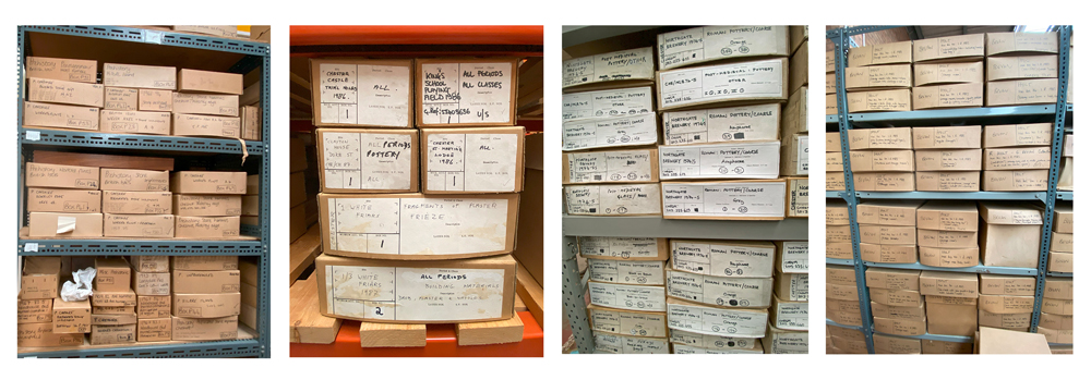
Many thanks to Pauline Clarke, the Excursions Officer of the Chester Archaeological Society, for organizing our CAS visit to the Grosvenor Museum Stores, and to Liz Montgomery of the Grosvenor Museum for taking us on a splendid guided tour. All the way round there were dozens of questions from the group, always the mark of a successful event.
It was a real eye-opener, not merely because of the box upon box of objects, but because of the amount of work that remains to be carried out. Many of the boxes represent excavations that have been published, but also those for which post-excavation funding was not available. Intriguingly, there are boxes of items from the excavations that took place when the old police headquarters was replaced with today’s HQ building, where St Mary’s Nunnery once stood.
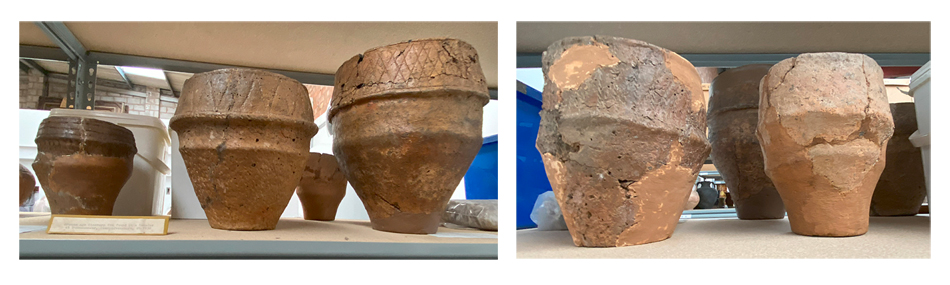
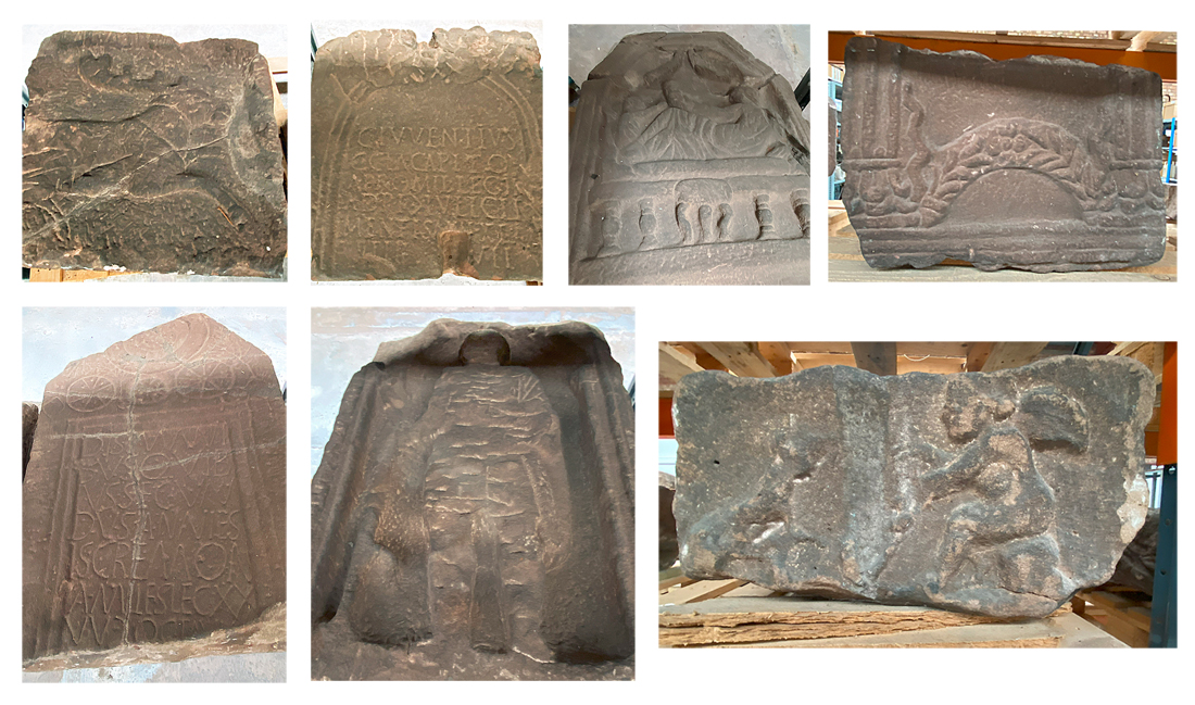
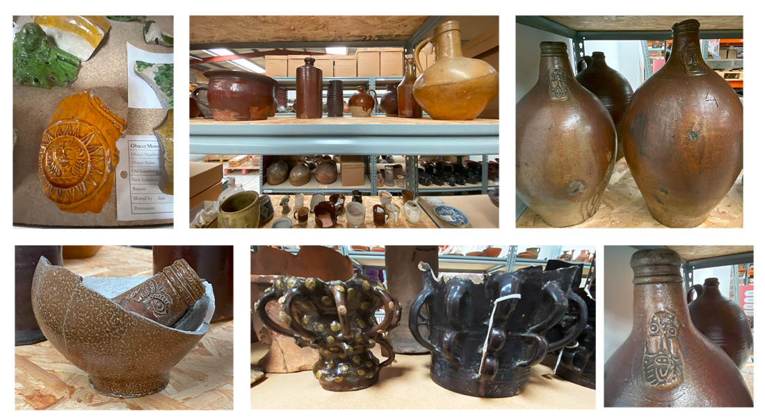
The storage boxes are stacked on racks, with organic and metallic remains kept in airtight containers and, in one of the storage sections, whole objects and big stone-carved fragments kept on display on some of the racks. It was fun to spot some boxes from Cuppin Street, where I excavated in the 1980s with a great group under the supervision of Simon Ward. Bigger objects, particularly Roman stoneware, are kept on palettes. There is a lot of Roman and post-Roman, including Medieval material, but there is also a collection of prehistoric items from the neighbouring area as well as the Cheshire ridge.
More recent items, from the earlier 20th century, are also lying on the shelves as well as in storage boxes, including wartime and inter-war period plus more recent objects.
All the contents of the storage facility have been carefully recorded, and many of the older boxes have been replaced with more appropriate specialized storage containers. Everything is kept clean and all items are accessible. These measures make the storage collection a very useful resource for researchers, who can take the selected storage boxes to a room equipped with tables and chairs (and an efficient radiator!) to explore the contents in comfort. It looks as though there may be opportunities for volunteers to contribute to this work in the future, which will be an excellent opportunity for non-experts to help the professionals to put the storage collection to good use.
This storage facility is largely dedicated to the museum’s archaeological collection, with a smaller set of items from more recent history, and the whole lot is utterly fascinating. This is not, however, the only storage facility for the museum. The old saltworks caverns have been converted into storage for some organizations, including the museum, and valuable items like jewellery, coins and other perishable metalwork are stored in a vault elsewhere. The 1000+ paintings collected by the museum, particularly under the aegis of Peter Boughton, are also stored elsewhere. As with most other museums, both this and the other Grosvenor stores demonstrate that what the museum has on display is just a fraction of what it holds, but also demonstrates just how much activity goes on behind the scenes, as well as the extent of the museum’s many responsibilities.
The photos below are a random selection of the many, many delights that the stores have to offer. Thanks again to Liz Montgomery for an excellent guided tour, which provided real insights into the value of a storage collection to the work of this and other museums.
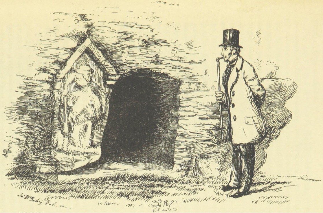
In 1858 the Roberts’ Chester Guide was published, with a series of engravings accompanying the text, one of which is the Minerva Shrine. Posted for no better reason than it provides a rather endearing 19th century take on the shrine, here it is, with thanks to Project Gutenberg, which has uploaded a digitized version of the book.
Located in Edgar’s Field in Handbridge, very close to the Dee, the Minerva Shrine is battered and water-eroded, and is a miraculous survivor of Roman Chester, carved into the red sandstone of the former Roman quarry. Minerva was goddess of artistic endeavour, craft and strategic warfare, the latter an interesting distinction from Mars who was the god of armed conflict in war. Her location in the Roman quarry as well as her association with the legionary fortress of Deva makes her particularly appropriate. According to Historic England: “It was made in the early 2nd century. It has a 19th century stone hood protecting it.” Although it is not the only example of an in-situ shrine in Britain (Peter Carrington has drawn my attention to other examples – in Northumberland and in Upper Coquetdale), it is certainly rare.
I love the map! ==
==
Messing around with my iPhone, this is the Minerva Shrine back in June 2024.
Hypocaust in the foreground with, in the background, the wall known as the Old Work, making one side of the former basilica.
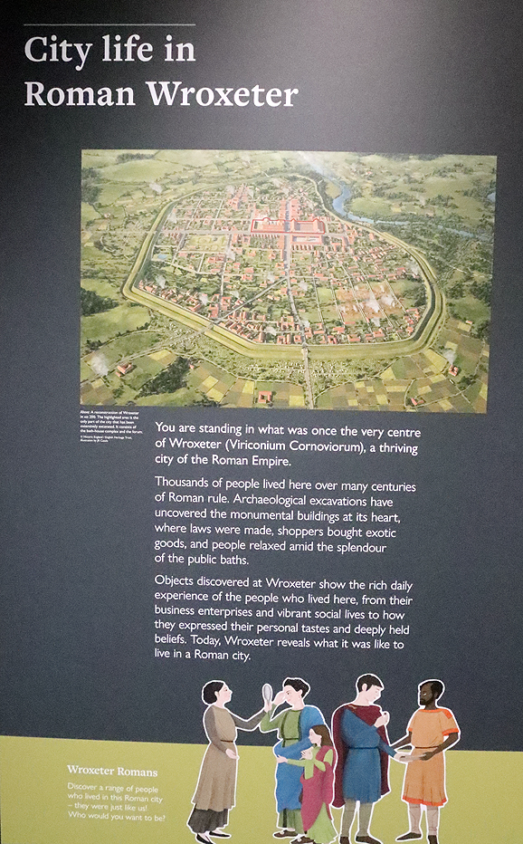
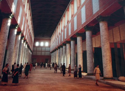
Founded in the mid-1st century AD next to the point of the river Severn where it could be forded, Wroxeter (Viriconium) was built on land farmed by the Iron Age Cornovii. It became a legionary fortress with the capacity to hold 5500 men in the 50s, becoming an urban centre towards the end of the 1st century, eventually becoming Britain’s fourth largest town, four times larger than the the legionary fortress. The remains of the site lie in a rural landscape to the east of Shrewsbury and is managed by Historic England. There is an imaginary reconstruction of a Roman villa. Indoors there is a very nicely presented Visitor Centre with exhibits and displays, as well as a small shop. Visiting details are at the end of this post.
Display in the Visitor Centre
There is little point repeating everything that the fact-filled guide book has to say about Wroxeter and its history, so this is just a short summary of what you can expect to see on a visit.
What remains of the site is a very small section of the original 192 acre (78 hectare) city, consisting of the lowest courses and foundations of the bath-house, part of a market-place and a row of column bases that marks one site of the forum. The road that carries visitors into the town follows the line of the Roman road, Watling Street. The city was surrounded by a 3-mile long circuit of ditches and banks originally topped with a timber palisade, now on farm land and not accessible to the public, but still visible on aerial photographs.
Information board in the Visitor Centre at Wroxeter
Unlike Chester, York, London and many other Roman urban developments that survived the departure of Rome, Viriconium was one of the Roman towns that were completely abandoned, beginning in the mid-3rd century. Looking out over the surrounding fields towards the Wrekin, after which Viriconium may have been named, it is difficult to imagine a thriving urban mass of public and private buildings connected by a maze of roadways and alleys. A series of archaeological excavations, however, have provided insights into what used to be here, and the visitor centre and guide book do a good job of explaining it.
The town was divided by the mighty Watling Street that connected it to London in the south, and to Whitchurch to the north, where the road forked with one branch going to Chester and the other towards the northeast, York and beyond.
Artistic reconstruction of the basilica on an outdoor information board
The most conspicuous feature of the site is the single piece of surviving wall, known as the Old Work, shown at the top of this post, which is what remains of what was one of the walls of the basilica, which was shared with the rest of the bath-house. The big opening in the wall marks where there were once double doors. The layers of brick-like stone blocks and tile work were covered in pink plaster, some of which would have been painted with decorative scenes.
Information board showing the main architectural features at the site with the basilica shaded in blue, the shops and marketplace side by side in the foreground and the bath-house taking up the rest of the space.
Changing rooms at the end of the basilica
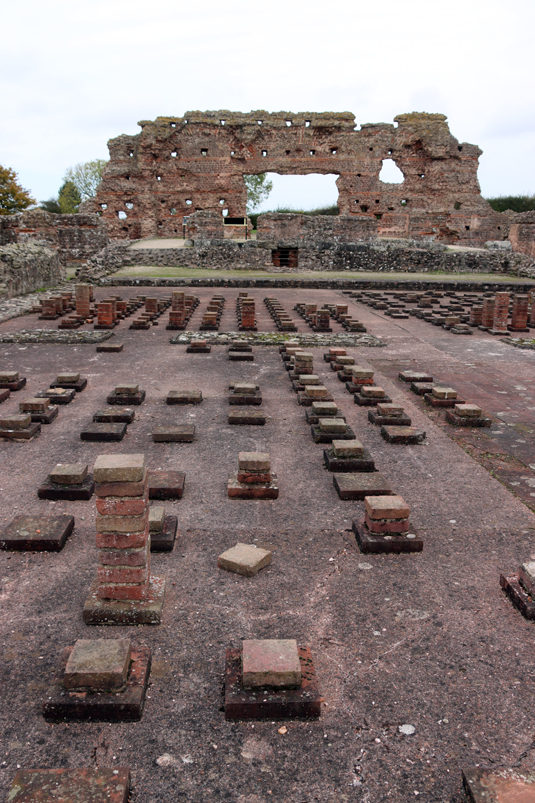
The bath-house, which has been excavated in its entirety, is the most complete part of the site, with remains of one wall, sections of the the hypocaust (raised heated floor) and the footprint of the baths’ basilica, giving a clear indication of the scale of the original complex. Bath-houses were an important part of Roman life, a component of civilized living and a good place to socialize and network. Even the small industrial base at Prestatyn had a tiny bath-house (posted about here). The Roman visitor to a big bath complex would usually begin in the basilica, a long thin space flanked by columns, where exercise and sports could be carried out in the central area, whilst the side aisles could have been used for personal care activities like massages and hair dressing. At the end of the basilica were two changing rooms.
The outdoor plunge pool
Then bathers moved through the baths in a sequence from an outdoor cold water plunge pool (heaven help them in this climate!) to an indoor cold water pool (natatio), an unheated room (frigidarium), a warm room (tepidarium), and a number of both wet and dry hot rooms (an alveus, caldarium, and sudatorium). Heat was provided in the warm and hot rooms via a hypocaust, consisting of regularly placed pillars of tiles that once supported a raised floor about 1 metre high, through which hot air was directed from three furnaces. Hollow box-like flue tiles were used to capture the hot air as it rose from below. A piece of decorated ceiling plaster from the hot room has been reconstructed, and copies are kept in both the Visitor Centre and the Shrewsbury Museum and Art Gallery.
Hot room
Reconstruction of ceiling plaster of the frigidarium in the Visitor Centre
Part of the western extension of the baths
Water from the baths was drained away beneath the bath-house and was used to flush out the latrines, the lower courses of which survive.
One of the shops that fronted onto Watling Street
Although the rest of the remains today lack the impact of the basilica wall section, mainly consisting of no more than two or three courses of stonework, these too were important parts of the civic quarter of the city, and there are explanatory information boards all over the site that explain what you are looking at and showing helpful artists’ reconstructions of how buildings may have been experienced by the Roman inhabitants.
Part of an information board showing the market place used by wealthy residents
Next to the bath-house is what remains of a market hall, with two storeys surrounding a central courtyard, containing shops that sold high quality food goods to the wealthy. This building survived into the fifth century AD. Nearby were other shops with open fronts overlooking Watling Street, which may have included food and drink for those using the baths, like modern take-away outlets or bars.
One of the ground floor shops in the marketplace
Colonnade of the forum, facing Watling Street
Over the road there is a line of column bases that are the remains of what must have been a very impressive forum, which was once covered 2.5 acres (1 hectare) and measured 80m x 120m (262 x 393ft). This consisted of covered buildings arranged in a square around an open courtyard. The buildings served administrative, legal and mercantile functions, and the ruins represent a colonnade that faced onto Watling Street. The central area was for an open market where stalls could be rented by local traders.
The reconstructed Roman house, a simplified version of excavated building “Site 6,” had a shop facing onto the street with accommodation at the rear. It was built in 2010 for a television programme and provides a good way of visualizing what Watling Street and other areas of Viriconium may have looked like.
The forum
The reconstructed Roman house
A room in the villa
Next to the house, but not open to the public, is the model farm built in the mid 19th century by Lord Barnard, and incorporates considerable amounts of Roman stonework in its construction. The farm is no longer in use but is maintained by Historic England.
The visitor centre and the lavishly illustrated guide book provide an excellent overview of the entire city’s history and what was found in archaeological excavations, with more information provided in the Shrewsbury Museum and Art Gallery.
Visiting
Prices and opening times can be found on the English Heritage website here. There is plenty of parking. The visit begins at the visitor centre, where tickets are purchased and you are given the option of taking an audio guide. I didn’t take one, but plenty of people were using them. There is a small shop where you can purchase a detailed guide book, and although it is impractical to read this as you go around the site, there is a site plan and an aerial photograph with all key features marked, both of which great to have as you walk around. The Visitor Centre is small but excellent, with plenty of helpful information boards and attractive displays of objects found at the site. There is no cafe but there is a picnic area with a few benches.
1st century harness mount showing Bacchus
The site itself is mostly on the flat, with pathways between all the main buildings and information boards explaining what you are looking at. There was a coach-load of children there at the time I visited and it is clear that for children, the villa was easier to get to grips with than the ruins themselves.
Nearby is St Andrew’s Church, which I very annoyingly missed but is widely recommended with some attractive and unusual features, some dating back to the Norman period. Both the church and the model farm, the latter not open to the public, are described in English Heritage’s Wroxeter guide book.
St Bartholemew’s, Tong
If you are driving via the A41, both Lilleshall Abbey and Tong’s St Bartholemew’s Church are well worth the visit. Tong is right on the A41, very convenient for a visit en route.
Near to Wroxeter is the 18th century National Trust Attingham Park property. Shrewsbury is not far, and has a really excellent museum and art gallery with a super Roman gallery with finds from Wroxeter. Shrewsbury itself is a lovely and apparently thriving town with a good mixture of architectural styles from the Medieval period onwards, including the vast church of the former Shrewsbury Abbey, some lovely half-timbered buildings and some fine Georgian architecture, as well as some great places to find lunch!
Sources
White, Roger H. 2023. Wroxeter Roman City. English Heritage (also includes St Andrew’s Church, the Victorian model farm and the reconstructed house)
Information displayed in the Wroxeter Visitor Centre
I have been trying to find a publication of the excavations that took place when the profoundly ugly Chester HQ office development was built on the site of St Mary’s Nunnery and its cemetery. This lead me to the article by Professor Howard Williams below. Outside the Chester HQ buildings is a very odd permanent display area made of red sandstone displaying bits and pieces of random archaeology. I’ve thought it was peculiar for a very long time, one of these token gestures, neither fish nor fowl, that are usually funded by developers when they build over the top of heritage sites. It has no cohesive message, no coherent linkage between any of the objects, and is anyway missed by most passers-by. This excerpt from a very nicely written article by Professor Williams (University of Chester), posted in 2017, really gets to the nub of the matter.
I see the vision but I can’t really get my head around the reality in a sympathetic way. Rather than evoking a history of place, reporting on the contexts discovered and the rich and varied social, economic, political and religious history of the city and this site’s place within it, instead we get a transtemporal pastiche. This is little more than a banal and context-free open-air cabinet of curiosities that shamelessly aggrandises the corporate architecture of the 21st century and its construction facilitated by the rifling of past times.
He goes on to discuss the display of one particular object, a truly lovely medieval stone grave cover with a fabulous decorative theme that represented the Tree of Life. It would have been laid horizontally over the grave, covering the deceased, but here is displayed vertically. This is really well worth a read if you are interested in heritage management, respect towards funerary monuments and contexts, the activities of developers with respect to the heritage they impact and the role of object histories. Loving the phrase ” transtemporal pastiche,” which gets it in one. Professor Williams never disappoints.
Back on the subject of the archaeological excavations, it was also interesting to note that in a 2013 article Professor Williams notes the following:
Archaeologist Mike Morris of Cheshire West and Chester Council was forced to announce that the developer – Liberty Properties – was in breach of their agreement [Cheshire Live] by not funding post-excavation adequately following the excavations at the HQ building revealing graves from Chester’s Benedictine nunnery. The website of Earthworks Archaeology – the commercial archaeologists who excavated the remains associated with the Benedictine Nunnery – says that post-excavation is ‘under way’.
The Cheshire Live article says that not only were there remains of 100 individuals from the cemetery at the nunnery site, but “foundations for at least one large Roman town house were discovered including an undisturbed mosaic floor – the first to be found in Chester since 1909.” The Earthworks Archaeology site announces: “The practice is currently on sabbatical.” There is no additional content and the website says nothing at all now. If anyone has any information about the excavations I would be grateful? But I suspect that it’s a horribly lost cause.
The last remaining structural feature of St Mary’s Nunnery – a 15th century archway that now stands in the Grosvenor Park.
Excavation without publication is an archaeological evil. If the remains carefully troweled out of the ground are not professionally published, the information is lost forever, the data never contributing to knowledge about the city as a whole and about the nunnery’s history in particular. It is the responsibility of an excavation not merely to extract data from the ground, but to share it. Anything else is an abdication of responsibility, and the loss of an important story. If the excavation results are never published, how will we ever understand what there was to know about St Mary’s? Where contracts are granted for this sort of work, surely the conditions of those contracts should be enforced.
The Chester HQ building where the nunnery once stood
Great to arrive home from our trip to our CAS introduction to Wirral-born stained glass artist Trena Cox by Aleta Doran (about which more later) and find the Heronbridge report on the doorstep. The report, “Excavations at Heronbridge 2002-5, Part 1: The Roman Settlement,” is a satisfyingly chunky 207 pages with maps, illustrations and photographs. It describes Chester Archaeological Society’s excavations between 2002 and 2005 at the Roman settlement at Heronbridge, about 2.5km south of Chester City Centre. With numerous contributors, headed by David J.P. Mason, it is edited by Peter Carrington with Rowan Patel and Alison Smithson (Chester 2024).
For those who wish to know a bit more about this publication, here are the cover details, the Table of Contents and the list of contributors. You can click to expand any of the images:

 Inscriptions carved in Latin onto Chester altars and gravestones have provided considerable information about their owners and the wide range of places from where those owners originated, as well as providing insights about the deities that their purchasers had considered most relevant and helpful to their personal hopes and ambitions, both in life and the afterlife.
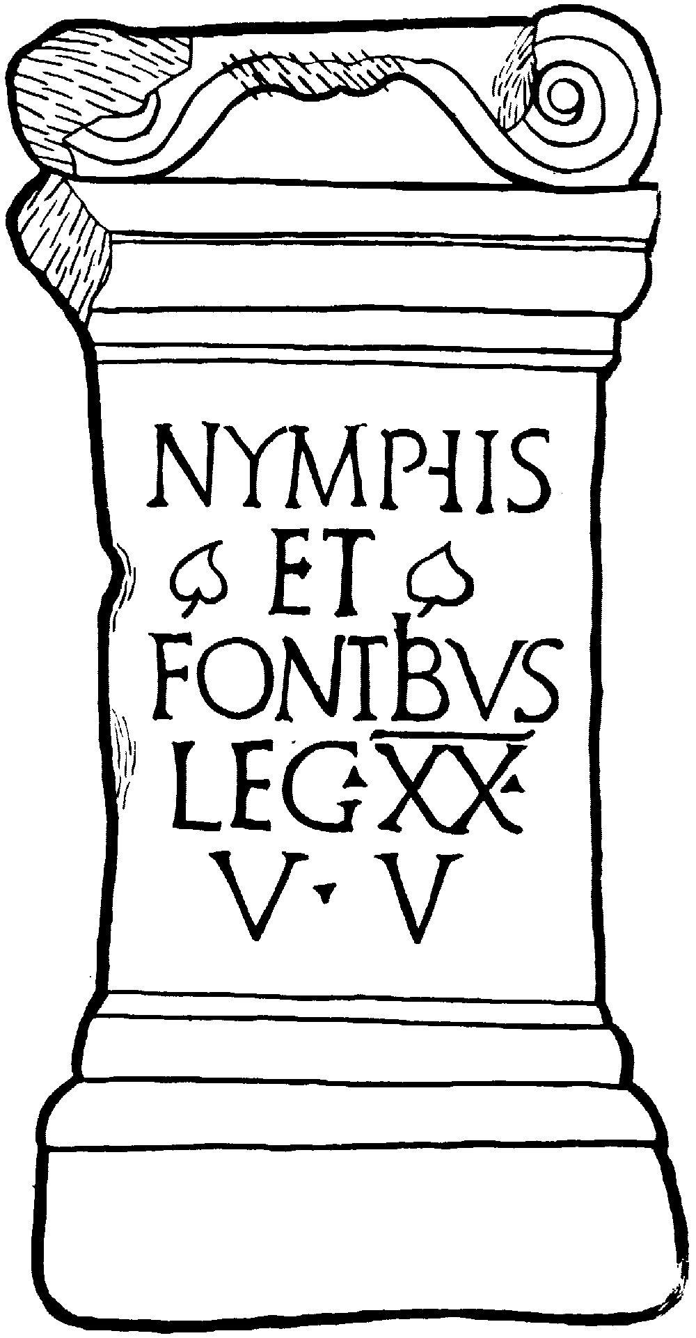


