Not for the first time I am writing about somewhere that I really ought to have talked about a long time ago because it is so near to me, in this case the Grade II* listed St Chad’s Church just down the road in Farndon. It is a lovely church, with a rather unexpected history, surrounded by a churchyard and enclosed by an irregularly shaped curving wall. Apart from the tower, there is very little of the medieval church remaining, having been almost completely rebuilt in 1658 following the damage inflicted during the Civil War, but it followed a broadly gothic template and is charming in its own right with a number of nice features, some influenced by the gothic, and others departing in interesting directions. It is particularly well known for the Civil War window installed by William Barnston.
St Chad’s Farndon
The congregation traditionally included those who were on the English side of the river, with burials from Churton-by-Farndon and Churton-by-Aldford, Crewe-by-Farndon, Barton, Leche, and Caldecott, and other nearby villages and farms. After 1866 residents of Churton-by-Aldford were often buried in at the Church of St John in Aldford.
During the summer I posted an account of St Chad’s Church in Holt, opposite Farndon on the other side of the river Dee, with its medieval links to Holt Castle and the Lordship of Bromfield and Yale. It is larger and more elaborate than St Chad’s in Farndon, and the two churches each has its own distinctive character with a lot to offer the visitor. Both churches were involved in the Civil War, due to the importance of the crossing here, and both bear musket ball damage as a result, but Farndon’s St Chad’s came off much worse than St Chad’s in Holt. xxxxxx
According to Bede (writing in the 8th century) St Chad was one of four brothers who entered the church in the 7th century, and started his training at Lindisfarne Monastery under St Aiden. He was ordained in Ireland and became a leading light in the Anglo-Saxon church, rising through the ecclesiastical ranks on the kingdoms of Northumbria and Mercia and under King Wulfhere, one of the earliest Christian kings. He was appointed Bishop of Northumbria, including York, and became the first Bishop of Lichfield in the new diocese of Lichfield, at the heart of Mercia. Mercia was one of seven British kingdoms of 7th century Britain and occupied most of central England. Chad died in AD c.672 and was buried in Lichfield Monastery, now Lichfield Cathedral. Regarded as a pioneer who helped to spread Christian teaching in and beyond Mercia, he became a popular icon during the Middle Ages in the Midlands and its borders. xxx
The Medieval Church
It is remarkable to think that the Civil War obliterated so much of the medieval church in 1643 that most of it had to be rebuilt in the 17th century. The Domesday book records a village priest, as well as two other priests locally, strongly suggesting the presence here of an earlier church, probably wood-built.
Today’s church has a nave and tower that are thought to have followed the original medieval footprint dating to the14th century building. All that obviously remains of the 14th century is the tower, of which three storeys date to around 1343. Everything else appended to this basic structure on north, east and south sides are later in date. Although you enter the church through an 18th century yellow sandstone porch, the thick wooden door itself is actually medieval, a quite astonishing survival.
Lines of the old roof of St Chad’s in Farndon marked on this photograph in white.
Inside, looking towards the tower from the nave, you can see the converging lines at which the old church roof met the tower, considerably lower down than the current roof, and terminating further down than the current arch. This suggests that the medieval church was both shorter and darker. Within the tower there are three chambers with one each for bell-ringers, another for the clock-works and the belfry itself, containing the bells, originally three, at the top.
In the north aisle in the interior of the church is a 14th century funerary effigy showing a knight in armour holding a shield carved with a Latin inscription reading “Here lies Patrick of Barton. Pray for Him.” Sir Patrick holds a sword in his other hand, and has some form of animal at his feet, now too badly worn to be identified with any certainty. This effigy is one of three that was found, but the other two were ground down to make white sand. Although Sir Patrick survived this particular indignity, he was used as a step into the belfry in in the 1900s, which accounts for the wear and tear to his face and the animal. Latham says that one of the other effigies was inscribed with the word “Madocusdaur” and a third was inscribed with a wolf.
John speed was the Farndon tailor’s son and was baptised in St Chad’s in 1552. There’s a good biography of him on the New World Cartographic website explaining how Speed followed his father into tailoring at a time when fashion was of growing importance, doing very well in the business, whilst at the same time pursuing his interests in history, geography, cartography, antiquities and genealogies. It was not until he moved to London that he gained a patron and was able to abandon tailoring and launch a new career. His map of the County of the Palatine of Chester was completed in 1610-11, and was used by both sides during the Civil War. He died in 1629 and is buried in London. xxx
The Civil War
Musket ball and cannon ball marks in the walls of the medieval tower.
The tower in Farndon’s church shows musket-ball and cannon shot damage to the exterior, to the right of the main porch, but the fact that the rest of the church had to be rebuilt in 1658 makes it clear that it experienced a much worse time of it than its counterpart in Holt. In 1643 the commander of the Cheshire and Lancashire Parliamentarian troops used Farndon and its church as a headquarters and barracks, assembling a force of around 2000 to force their way across the bridge, through Royalist defences. The subsequent fighting entered the churchyards at both Holt and Farndon. During the fighting in Farndon churchyard the roof was somehow set alight. In spite of the damage to the roof, the Parliamentarians reoccupied the church until they were ousted in winter 1645. xxx
The 17th Century Rebuild
Apart from the tower at the west end, the current red sandstone church with its slate-tiled roof is largely the result of the post-Civil War rebuild in 1658, presumably re-using some of the original medieval stonework. The main body of the church consists of a nave with clerestories (a run of windows above the nave below roof level to allow in light) and two aisles, terminating in the chancel at the east end. The 5-bay arcade separating the nave from the aisles consists of round piers (columns) with simple capitals and pointed arches. Over 40 different mason marks are dotted throughout the church, each one identifying a separate mason, giving a hint of the scale of the workforce required to rebuild St Chad’s. There used to be a musician’s gallery at the tower end, but this was removed in the 19th century.
Mason’s mark on the arch between the nave and the tower
The nave of the 1658 nave, arcade and overhead clerestory. The entrance to the Barnston chapel is shown at lower far right.
The new church was taller than the old one, with the clerestory and the large Gothic-style lancet windows letting in much more light. The tower was provided with a new top section at this time.
Adding to the footprint of the old church, the Barnston family, major landowners in the area, built a small chapel off the chancel end of the south aisle, for their private use and to bury and commemorate family members. According to the church’s history booklet, there are records mentioning Barnstons in Churton during the reign of Henry VI in the 15th century. In the 17th century William Barnston was a major contributor to the rebuild of the church, and requested that he be buried under a gravestone in the south aisle of the church that has already been placed ready. His 1663 will left a substantial bequest to the church for its upkeep. He died in 1664.
The Civil War window, St Chad’s, Farndon
An adviser to Charles I at the Siege of Chester, William Barnston was responsible for the famous Civil War window in the chapel. What surprises most people who see it for the first time is how small it is, but it is full of details that show Royalist participants, including Barnston himself, and a variety of items of contemporary clothing and equipment used in the Siege of Chester. Pevsner and Hubbard say that the technique is “decidedly Dutch” and Latham adds that “Its artist took his design for the armour from a military work by Thomas Cookson (1591-1636) and for the bottom border from prints by Abraham Bosse (1632).” My photo, left, is very poor due to the lack of light, but have a look at the Visit Stained Glass website for a much better image and a close-up of the depiction of William Barnston.
There are many features of interest to look out for in the 17th century church. In the south aisle there is a rather fine sculpted wooden beam support. The church’s booklet questions whether it is a human or an animal but it looks very like the lions with curly manes that are familiar from Tudor and Jacobean carvings. It is surprising that it is on its own. The damaged medieval font was repaired by Samuel Woolley of Churton but the current octagonal font is thought to date to 1662, replacing the repaired one. XXXxxx
18th, 19th and early 20th century alterations
Georgian style porch, St Chad’s
According to Frank Latham, by 1735 “St. Chad was surrounded by green fields and the houses were few and far between,” and the Massie family seems to have been important to the congregation at this time, with six pews allocated to Richard Massie Esq., and his family. He adds that the east wall was demolished in the 18th century and shifted 10ft (c.3m) further to the east, providing a much larger chancel. Towards the end of the century repairs to the roof were made between 1793 and 1798. Today the red sandstone church is entered via a Georgian-style porch built in yellow sandstone, although I have seen no mention of a precise date for this, and inside there is a large 18th century oak chest that housed the church plate and the parish records.
Memorial to Francis Fletcher 1782
The eastern end of the church was remodelled to include today’s chancel in 1853, not by the Barnstons this time but by the Marquess of Westminster. The carved reredos behind the altar shows the Last Supper and was installed in 1910, with the carvings on the pulpit were added in 1911, showing St Chad accompanied by the usual pulpit team of Saints Matthew, Mark, Luke and John, represented by their emblems. In 1927 the original three bells were joined by another five. The church booklet says that they were rung to mark nationally important occasions, including the defeat of Napoleon in Egypt in 1799, and his defeat at Trafalgar in 1805.
Of the various memorials, one that may be of interest to those familiar with the Barnston obelisk just outside Farndon, is the marble memorial to the Major Roger Barnston (died 1847) in the Barnston chapel. The obelisk in the field on Churton Road, now a natural burial ground, is also a memorial to Major Barnston (died 1847) discussed on the blog here,
The north aisle, like nearly all churches in this area, used to have a clear run to the end of the nave, but the presence of an organ since the 19th century regrettably meant that a gallery just in front of the tower’s arch, where musicians located, became redundant and was removed. The present organ dates to 1949.
St Werburgh and St Chad stained glass in the chancel
The windows are often round-topped, set within rectangular frames that give the exterior an unusual appearance. Exceptions are the large east window behind the altar, installed in 1858 and showing the Sermon on the Mount, installed in memory of church benefactors William and Anne Plumpton, and the south window in the Barnston chapel, both gothic-style.
Most of the stained glass is interesting for the contrasting styles. Following the Trena Cox: Relections 100 exhibition in Chester last year I have become quite interested in 19th century stained glass. On the north side of the chancel, to the left as you face the altar, is a window showing St Chad and St Werburgh (to whom Chester Cathedral was dedicated when it was a Benedictine monastery), by Trena Cox. A look at Aleta Doran’s website devoted to Trena Cox confirmed that this was one of hers, from the 1950s (1953 to be exact). Those windows immediately opposite are similar in style but were clearly crafted by a different artist and show St David (patron saint of Wales) and St Cecilia. Most of the other stained glass was added in the 19th century, with many of the larger window openings being decorated with romantic takes on the gothic, whilst smaller ones are more minimalist. It was a little sad not to be able to learn something about the makers of the glass either at the church or after a hunt through my books and around the Internet.
Window dedicated to the memory of Harry Barnston installed by his sisters after he died in 1929, in somewhat Pre-Raphaelite style
Stained glass in the Barnston chapel, emulating gothic tracery and themes
At the rear (south side) of the building you can see a substantial addition at the west end (near the tower) and I assume that this was a 20th or 21st century add-on, presumably acting as a vestry and storage. xxx
The Churchyard
The churchyard includes a mixture of different types of grave, including chest, table and ledger tombs and vertical headstones, some accompanied by kerbs, mainly of good quality yellow sandstone. A particularly fine example is a Grade II listed double-chest grave made of yellow sandstone and dating to the early 18th century :
West ends of tombs have recessed round-headed panels; that to north contains an hourglass, that to south a skull and crossbones above an inscription Mors S… Omnium [i.e. Mors Sola Omnia,” meaning Death Conquers All]. North side of north tomb has a square central panel containing an encircled quatrefoil in a lozenge with a vertical panel right and a decayed panel left. The east end of each tomb has a fielded panel; south side of south tomb has 3 fielded panels in bolection moulded borders (Historic England – list entry number 1228746)
It was sobering to notice just how many of the chest grave inscriptions commemorate infants and children. I always spend an hour or so reading grave inscriptions and don’t remember seeing so many very young children commemorated, often from the same family in the same generation. As you would expect, the earlier graves are nearest to the church, although unusually many of these are on the north side, which is normally the last to be filled.
Red sandstone gravestone covered in yew berries
Moving away from the immediate area surrounding church building, to its south, the traditional upright gravestones of the later 19th century begin to dominate, with many examples of 19th century funerary symbolism on the headstones. Although many of the headstones are lancet-shaped and much of a muchness in terms of size, there was clearly a lot of choice available in terms of the symbolic motifs that decorated the tops of the graves.
Art deco style headstone
Through a small gate beyond the headstones, the churchyard has been extended for modern use. The 1922 War Memorial in the form of a stone cross commemorates eighteen men killed in the First World War and four in the Second World War. xxx
Final Comments
This medieval church, almost completely rebuilt in the 17th century, has a character of its own, reflecting various periods of restoration and intended improvement, with a strong gothic influence throughout. There are many more features than those described above, including benefaction boards, a list of incumbents, and memorials, and the church booklet produced by Cheshire County Council in 1989 is a good guide.
The church website contains no information about visiting, and the Facebook page hasn’t been updated since 2019, but at the moment the church has an open door policy. On my two recent visits (October 2025) I was able to walk in. There is a contact page on the site, so if you are coming from any distance it might be worth double-checking.
It is splendid to have two really impressive churches, one either side of the river connected by a splendid 14th century bridge, with very different personalities and features, and both very well cared for and open to visit.
Sources:
Books and papers
Cheshire County Council 1989. The Parish church of St Chad, Farndon. (10-page booklet available for purchase at the church)
Latham, Frank 1981. Farndon. Local History Group
Pevsner, Nikolaus and Edward Hubbard 1971. The Buildings of England: Cheshire. Penguin Books
Many thanks to professional visual effects and 3-D graphics modeller and independent researcher Julian Baum for a really fascinating presentation about new research into the River Dee.
One of Julian Baum’s beautiful reconstructions of Deva and its outer buildings in the mid 3rd Century, based on data from archaeological excavations, showing the Roman town in the context of the river and the widening estuary beyond.
The talk focused on how the Dee’s formation, archaeology and several historic maps have raised a number of questions about the Roman river. Julian made it very clear that the presentation would consist of a number of hypothetical scenarios based on observable features, none of which can yet be fully supported by the available data. He and his fellow investigators Rod Hobbs and Peter France have been compiling their data for the last six years, and have produced a 17,000 word paper that has been sent out to experts on Roman stonework and hydraulic engineering for consideration. As they continue to assemble responses to their proposals, the team are also looking for opportunities to work with other specialists to extract more data from the field. So, accepting that these ideas need more data to test the hypotheses presented today, what are the questions being asked?
The presentation followed the formation of a new research group, which met in June for the first time and included specialists in a number of relevant fields. A great many questions were asked at that meeting, but the two overarching research questions are as follows:
1) What do we know about the geology and geomorphology of the Dee valley in the Chester area? Although multiple glaciations impacted the underlying geology of Britain, it was the impact of the last glaciation that is of most interest for the second question.
2) What do we know about Chester and the nearby archaeology, from the prehistoric to early Medieval periods, with particular focus, initially, on the Roman period?
Julian Baum’s presentation then went on to introduce the geology and glacial history of the Dee valley before going on to describe three key archaeological questions.
The Chester weir
First, how old is Chester’s remarkable weir? Traditionally it has been dated to the Norman period when the notorious Hugh d’Avranches, better known as Hugh Lupus, began to introduce substantial architectural and civil engineering works to develop a strong economic, religious and social foundation for Chester. There can be no doubt that Hugh Lupus undertook works on the weir. What is less certain is if he was the first to establish a weir here. The proposal by Julian Baum, Rod Hobbs and Peter France, just an intriguing theory at this stage, is that the weir may have been a Roman innovation, mirroring hydraulic works elsewhere in the empire, required to raise the level of the river upstream to enable the vast barges carrying essential building materials from Holt. The initial round of research described in the presentation has produced considerable quantities of data about the river bed, about post-glacial sea levels and tidal information, as well as looking at all the available archaeological data published to date. Divers have been consulted and the river boat captains have provided invaluable information about their own experiences with the river depth today, as well as seasonal variations in the navigability of the river. As the presentation emphasized, much more research is required to test this proposal. An academic paper has been written by the three researchers and is currently being circulated amongst specialist in the field, who have all expressed an interest in assessing the hypothesis.
The Braun map of 1571
The second question concerns two 16th century maps of the Roodee that show that the north western edge was an almost straight line. How can this straight line be explained? Building on earlier archaeological discoveries the same researchers propose that this edge may have marked the position of a very long Roman timber jetty. The line of wall usually identified as the old Roman quay near the modern HQ building at the east of the Roodee has been widely discredited, so the question of where the Roman quay was located remains open. This proposal makes a great deal of sense, but it too needs testing, and Julian Baum proposed a number of ways in which this could be done using specialist equipment and taking advantage of the upcoming building works at the Roodee. An interesting corollary to the proposal is that if there was indeed a jetty there, supported on presumably vast timbers, and of a width to enable wheeled vehicles and horses to reach ships moored up along its length, its collapse would have created a major disruption to river flow, and could have had a considerable impact on the silting of the river.
Chester amphitheatre
The third question concerns the archaeology of Chester and its environs prior to the arrival of the Romans. Iron Age remains were found during the amphitheatre excavations of the 1980s, and there are other indications that there was a healthy Iron Age presence in the area before (and when) the Romans arrived. This data needs to be collated before it can be assessed, and this is another aim of the research group.
All findings will be made available online on a dedicated website that is currently being built. The website address will be made available as soon as it is launched.
With many thanks to Julian Baum and other team members, who were present on the day, for such a fascinating presentation.
I have been visiting Dinas Brân on and off for decades, but have never got around to writing it up. It was one of my favourite walks with the family dog in the 1980s when my parents lived hereabouts. Much later, a regular return trip between Aberdovey and Rossett gave me the opportunity to see the castle from various different angles in all sorts of weather, the conical hill on which it sits soaring from the Dee valley providing a commanding, impressive position that dominates the landscape. I recently drove into Llangollen to go up to the castle on a hot day, prepared for a moderately steep walk from the canal bridge, correctly anticipating a slightly breathless arrival at the ruins.
This is a splendid walk. It is only about 2km (1.3 miles) from the Eisteddfod Pavilion, where I parked, although uphill all the way from the Wern Road canal bridge, so it feels longer, and the views towards the castle and back over the valley are splendid. The views from the castle itself are of course stupendous, both aesthetically and geologically. The geology and geomorphology are mentioned in brief below. More about parking, the different routes and conditions underfoot are towards the end of the post in Visiting.
Castell Dinas Brân, a Scheduled Monument, is the story of two fortifications, one dating to the Iron Age, at around 600BC, the other a medieval castle dating to the 13th Century. It is far from unusual to find Medieval castles built within the circumference of an Iron Age hillfort, because both were making use of the same strategic features: a good view of the surrounding countryside, a defensible position, often above cultivable land, and access to water. This post is about the Medieval castle.
xxx
History of Castle of the Crows
The medieval castle
Window of what was possibly the Great Hall of Dinas Bran
It is not certain which of the Powys Fadog rulers built Dinas Brân. The most common suggestion is that the castle was built by Prince Gruffudd ap Madoc (c.1220-c.1270), beginning in the 1260s, but there is an argument discussed by Paul R Davies that it may have been built by his father Prince Madoc ap Gruffudd Maelor.
Valle Crucis Cistecian Abbey, founded 1201
From c.1190 Prince Madoc was ruler of Powys Fadog, the northern section of Powys, which had been split into two on the death of Madoc ap Maredudd in 1160. He founded the nearby Cistercian abbey in 1201, and although his territory was comparatively small, he clearly had ambitions to establish his name and ensure his legacy, A castle would have been consistent with that intention, and as Davis points out, materials and workers could have been shared between the two sites. Prince Madoc died in 1236 leaving four sons, of whom Prince Gruffudd was the only one to survive. Whether Madoc started work on the castle or not, it is clear that Prince Gruffudd continued it, completing it well before the war of 1277.
Together with Powys Wenwynwyn to the south, Powys Fadog was sandwiched between the much larger territory of Llywelyn ap Gruffudd’s Meirionydd in the west of Wales and England to the east. Llywelyn (c.1223 – 11th December 1282, also known as Llywelyn the last, grandson of Llywelyn the Great) and his brother Dafydd (1238 – 3rd October 1283) had been in a long-term power struggle with Henry III that erupted once again under Henry’s son Edward I. Whilst the northeast territories provided a buffer zone between the two warring factions, their rulers were inevitably dragged into the question of where to bestow their loyalties. There was never any certainty that the members of a single family would throw in their lot with the same side, and some, like Llywelyn’s brother Dafydd, switched sides at least once.
Wales following the 1267 Treaty of Montgomery showing Powys Fadog sandwiched between Gwynedd and England. Source: Turvey 2002, p.xxvii map 8
Prince Gruffudd was married to an English wife, presumably for diplomatic reasons, providing a nod of friendship to the English. With Lady Emma Audely he had four sons, the eldest named Madoc, and one daughter. Presumably seen as fair game by Llywelyn, Powys Fadog was attacked. When Henry III was appealed to for help but did not come to Powys Fadog’s aid Gruffudd seems to have thrown in his lot with Llywelyn, arranging for peace between Meirionydd (Gwynedd) and the return of his territories by agreeing to the marriage of his eldest son Madoc to Llywelyn’s sister Margaret. Dinas Brân was apparently built in support of the interests of Llywelyn the self-styled Prince of Wales, borrowing certain elements of architectural styling from Llywelyn’s castles, including the D-shaped tower at its southern side.
Gruffudd apparently died in around 1270, because it was in this year that his sons signed a grant to provide Lady Emma with lands of Maelor Saesneg to secure her future. At this time ownership of the castle would have been split four ways between his sons, because primogeniture was the English but not the Welsh system of inheritance. Instead of one son or daughter inheriting an estate, on the death of a father all property was divided between the remaining sons, with provision usually made for wives and daughters. Each of Prince Gruffudd’s sons had his own decision to make in November 1276 when war broke out again between England and Wales. However they started the war, Gruffydd’s eldest sons eventually submitted to Edward, but in May 1277 an English force sent to take possession of the castle found it in engulfed in flames and it was evident that the garrison left behind had remained loyal to Llywelyn. The decision to burn and abandon the castle rather than defend or surrender it did not, however, completely destroy the castle.
After the Treaty of Aberconwy in 1277 Llywelyn paid homage to Edward, sitting to the left of the king’s throne, with Alexander of Scotland at the king’s right. The peace did not last.
After the Treaty of Aberconwy in 1277, Llywelyn’s power was confined to northwest Wales. The English inspection of Dinas Brân to assess the damage caused by the fire found that although considerable superficial damage had been inflicted, the well-built castle was structurally sound and still of strategic value. Henry de Lacy, Earl of Lincoln, wrote to Edward I recommending that the castle be repaired and garrisoned with English troops.
Following Edward’s triumph, Powys Fadog was abolished as a territory. Edward gave ownership of the castle and all its lands to John de Warenne, the early of Surrey. The castle, however, was no longer relevant as a symbolic stronghold of the former territory and now stood at the borderland of the new friendly lordships of Chirk, held by Roger Mortimer, and Bromfield and Yale by John de Warenne. Instead of devoting any attention to Dinas Brân, de Warenne became busy building his new castle at the eastern end of Bromfield and Yale on the Dee crossing at Holt near Chester.
Ruins of Dinas Bran
There is no record of the role performed by Dinas Brân, if any, during the final great conflict between Llywelyn and Edward of 1282, when the English were triumphant. Llywelyn died on the battlefield that year, and Dafydd was captured and put to death in 1283. As Holt Castle grew, Dinas Brân was abandoned.
A completely unsubstantiated legend concerns the fate of the two underage sons of Prince Madoc, Gruffudd’s eldest son. Walter Tregellas in 1864 tells the story, in which Edward I conferred guardianship of the two boys on Roger Mortimer and John de Warenne: “it is stated that the two children were soon afterwards drowned under Holt Bridge . . . This is said to have happened in 1281.” He goes on to recount an even better version of the conspiracy, however: “it is uncertain whether the king himself did not cause the children to be put to death.” There is no evidence whatsoever about what became of the two younger children of the prince of Powys Fadog.
Dinas Bran and the wonderful scenery beyond
The only hint that they castle buildings may have been re-used is a poem by Hywel ab Einion Llygliw Myfanwy Fychan in the 14th century, in which he claimed to have been rejected by the beautiful girl who lived there. There is no evidence to support this later domestic occupation, but neither is there anything to deny it. John Leland, visiting in 1536, found it in ruins.
The Victorians
Dinas Brân Castle by Alphonse Dousseau, c.1850. Source: The National Library of Wales, via WikiData.
When ruins became desirable romantic destinations, Dinas Brân was an obvious lure for painters (many of whom chose to paint safely from below) and more adventurous tourists. The Holyhead road was the major route through north Wales, with Telford’s great route, now the A5, opening in 1826, and the railway was opened in 1864. A local entrepreneur, demonstrating great faith in the spirit of adventure demonstrated by the new tourists, decided to make the most of the popular site and the first visitor provision was supplied in 1820, with a cottage added in the 1880s as a tea room together with an octagonal camera obscura, which was still in situ by the start of the Second World War.
Walking up the hill not far from the summit I found a piece of slender white clay pipe, about an inch long, on a piece of well-worn hillside. This almost certainly belonged to the period of Victorian interest in the castle.
Victorian cottage built for serving teas to visitors on Dinas Brân. Source: People’s Collection Wales
The castle as it stands today
Fieldwork
Plan of Dinas Brân, both prehistoric and medieval, following the geophysical survey of 2017
There has been very little fieldwork at Dinas Brân, and even the antiquarian investigators who explored other sites seem to have felt that this was one challenge too many. The only exception appears to be alocal treasure hunter who is mentioned in a journal entry by Lady Eleanor Butler of Plas Newydd, whose home was in full view of the castle, and who commented that their landlord had informed them that a smith from Dimbraneth “has been dreaming of more than a year past of treasure at Dinas Brân. Hew has within this week begun to dig.” There is no report of any discoveries.
In 2017 a geophysical survey was carried out and this was quite comprehensive, addressing both the medieval castle and the prehistoric hillfort. Although nothing conclusive was discovered, magnetic readings did suggest that a fire had scoured the ramparts, perhaps tying in with contemporary reports that the sons of Prince Gruffudd had set fire to the entire structure rather than surrender it to the English.
In 2020 a survey was carried out by the Clwyd Powys Archaeological Trust (CPAT) to assess the condition of the site, both the castle and the prehistoric hillfort, making recommendations to make it safer and more approachable for visitors and to manage archaeological impact. Earthworks were noted beyond the hillfort but were not included in the survey.
CPAT excavation at Dinas Brân in 2021. Source: Heneb
It was not until August 2021 that the first archaeological investigation was carried out at the site, organized by CPAT. It was a small exploratory dig, with four trial trenches both within and outside the castle walls. The main aim of the project was less investigation of the history and more about assessment of the condition of the building’s foundations. Although the excavations did no more than reveal the medieval floor surface, one sherd of medieval pottery was recovered and a “ledge/kerb was discovered projecting from the gatehouse wall, with a portcullis slot in it near the east end, and a fine masonry carved pillar base at the western end.” In 2021 the Heneb report said that the excavation report was “awaiting a second phase of work in 2022,” but I have been able to find nothing about a 2022 excavation and no further reports.
Modern conservation work was carried out by Recclesia, who surveyed the site and inserted stabilizing rods into the south wall of the castle to ensure that it stays upright now and in the future.
The surviving architecture
Detail of an old interpretation board
The plan drawn by Tregellas in 1864. with annotations
The castle was very fine in its day, with imposing fortified walls and stone and timber buildings. There are hints that there were decorative features. I have annotated the plan drawn in 1864 by Walter Tregellas to make this easier to follow. If you have walked up from Llangollen, and climbed the east-facing slope of the hill, you will have entered opposite the original entrance. I had had a long wander around before tackling how the ruins relate to the original layout but when I got stuck into the site plan, I started at the entrance.
The ditch surrounding the castle
The site consists of a rectangular court orientated east-west, c.82m by 35m, surrounded by a ditch dug out of the bedrock, which provided the material from which the castle was built. As well as building materials available within the immediate vicinity, it was found that there was sandstone facing in certain parts of the castle, which would have provided it with both refinement and prestige. It is not clear where this came from, but it is likely that it was sourced from the same location as the Valle Crucis ashlar. The ditch surrounding the castle was an impressively deep and wide feature, running around three sides, the northern side of the castle being positioned directly over a steep drop. At the southwestern corner of the ditch was once a well, the location of which is now very difficult to see.
An artist’s impression of how the gatehouse (right) and the keep (left) as they may have looked when it was first built. Source: Clwydian Range and Dee Valley
The original entrance was marked by a gatehouse that, being one of the points of weakness of the castle, was built so that it could be well defended, with twin English-style towers forming a gatehouse, each with hollow basements and, remarkably, appears to have been furnished with highly ornate rib-mouldings. This is unprecedented in Welsh castle design and may have been copied from an English example. One of the two gate towers still has the underfloor barrel-vaulted arch that was accessible from the courtyard; although it is now open to the outside, this would have been closed in the 13th century and is probably the enlargement of an arrow slit. The vaulted room is closed to the public except on special open days. The gatehouse was supplied with latrines on its northern side, that emptied down the walls into the ditch.
The vaulted undercroft in the gatehouse
The stairwell that lead up to the first floor of the keep
Heading clockwise from here, you encounter the square keep. This was once an impressive building that helped offer protection for the gatehouse as well as the most vulnerable eastern approach. It will also have provided a home for the main family members and a final retreat at a time of siege. It was equipped with latrine which, like the gatehouse, emptied into the ditch. Additional security was provided for the keep. It could only be entered via a first floor door reached by stairs from a walled passage, and was separated from the rest of the castle interior by its own ditch, which would have been crossed by a liftable bridge.
Continue around to the right to follow what was once the long south curtain wall. The section of wall with two giant openings in it was either the site of the castle’s Hall, where dining and socializing would have taken place, or its chapel. The two openings, providing plenty of light for interior, would have been about 1.8m (6ft) wide at their maximum width. They would have had shutters to protect the castle from the elements, but no window glass.
At the far end of the Hall a doorway opened into a D-shaped tower that extended beyond the line of the curtain wall. The D-shaped section has gone, but this tower was a major feature of the castle, rising to two if not three floors. A good surviving example can be seen at the well known Ewloe Castle (about which I have posted here). Again, this was a defensive measure providing archers good views over the ditch and the flanking walls. The ruins of the inners walls give a sense of the size of this half of the room. It is likely that part of this was used for the castle kitchens, which gives weight to the argument that the adjoining apartment was the dining hall rather than the chapel.
Further along this stretch and you will find yourself looking out between two sections of wall, a gap that represents the remains of the postern gateway. As well as providing a useful secondary pedestrian entrance on the opposite side of the castle from the main gatehouse, this could also be used as a “sally port” that would allow foot soldiers to mount a surprise attack from an unexpected position.
A rectangular building at the west end may have been either the hall or the chapel or served another purpose. This area is likely to be highly disturbed, archaeologically, due to the Victorian building works in this area. The rest of the interior would have been filled with timber-built buildings, including accommodation for servants, storage, stables and workshops.
The landscape
xxx
British Geological Survey geological timeline.
Standing on the peak of the hill, you are 305m (c.1000ft) above seal level. Geologically, Llangollen is divided into two main formations. At the top of Dinas Brân you are standing on one and looking at the other.
Beneath your feet the rock formations are dark grey Silurian shales and silstones, which were laid down as deep sea sediments and then subjected to metamorphic processes. These are the same rocks that you see in the Dee river bed from the Llangollen bridge, with the rapids flowing over them. The stone quarried from the ditches of this Silurian hillside were used to build the castle, and are uncleaved, around 30-40cm thick.
Above this layer in Llangollen is the heavily layered Carboniferous limestone escarpment that so dramatically forms a backdrop to Llangollen and Dinas Brân, laid down when the sea was warm and shallow. The Devonian, which theoretically should have sat between these two geological periods, is missing, presumably because it was not under water in this area at that time, and did not form the rich, deep layers usually laid down in marine contexts.
The solid geology of Clwyd showing rock types. Jenkins 1991, p.14
Geomorphologically, the Vale of Llangollen is a typical U-shaped valley carved by the advancing ice and associated debris of the Welsh Ice Sheet as it advanced east. The river Dee wends its way through this flat base, and former river beds are visible in the landscape, the former routes of the river blocked by the ice sheet, forcing water to find a new passage.
The plant life that has settled into place on this isolated outpost is typical species that are capable of surviving on highly exposed rock with very little topsoil. Drought-resistant annuals like foxgloves and swathes of rock-hugging perennial succulents like sedum anglicum are dominant at this time of year.
xxx
Visiting
Map of the footpaths to Dinas Brân Castle (Kightly 2003, Denbighshire County Council)
The castle is on the open hilltop and is free of charge to access. There are no facilities at all. You will need to take water and any snacks with you, although there are plenty of facilities down in Llangollen itself.
There are two main approaches to the castle for walkers arriving by car from the east. One is a longer walk from the valley bottom, and the other is a much shorter but slightly steeper walk from the other side, approached along the narrow road now marked on the map as the Offa’s Dyke Path (even though Offa’s Dyke does not actually follow this exact path). A map taken from the bilingual booklet Castell Dinas Brân Llangollen (in their Enjoy Medieval Denbighsire series) shows two alternative routes, with variations.
The easiest place to park if you are heading up from the valley is the International Eisteddfod Pavilion (marked as the Royal International Pavilion on the map), which offers a really lovely walk along the canal to arrive at the canal bridge where you cross to begin the walk. The second approach is much shorter and takes you from the Offa’s Dyke Path, a single-track road that follows the line of the hill, and has spectacular views; there is no official parking here, although there is space to pull over and park for about 4-5 cars (being careful to leave passing spaces) and this gets full very quickly on fine days.
Both routes require sensible footwear, whatever the weather. I was wearing some excellent lightweight hiking trainers with heavy tread, perfect for a hot day, but in damper seasons I would go for hiking boots. Although the path starts off metalled in Llangollen itself, mainly because it is one access point to the local school, it becomes much more uneven underfoot as the path goes on, with patches of coarse bedrock and scatterings of loose scree.
The Eisteddfod Pavilion is on the A539 on the way out of Llangollen towards Valle Crucis and the Horseshoe Pass. The car park is big, with a pay and display system. From here, go up out of the car park towards the canal bridge, and go down on to the towpath to the left of the bridge, turning to the right under the bridge to head east in the direction of Llangollen. This is a lovely stretch of canal, passing the marina on your left.
When you reach the next canal bridge, with a cafe on the right, walk up on to the bridge. Directly in front of you, heading straight up a short flight of stairs, is the public footpath.
From here on it is easy to find your way. Just keep going straight up. You first pass the school on the left, and a field on the right, with a gate at the top of this first stretch. Go through the gate, cross the lane, and keep going up the other side.
You will pass various attractive buildings along the way, the largest of which is the Grade II listed Dinbren Hall, built with conviction but without a great deal of imagination in a very lovely location in 1793.
Soon you will reach another gate. This has signage on the other side of it warning to inform you that you have now arrived at the foot of the hill, and to keep dogs on a lead (there are sheep all the way along this walk).
It is less even underfoot from here, with a very short uneven patch, but you will find that just over the other side the path opens out onto the hillside, with a clear view of the path ahead.
A very short uneven section of path, but it evens out just on the other side
Beyond this, along the steepest part of the route, the ziz-zag path marked on the map is beautifully maintained at the time of writing, with occasional stretches provided with a hand rail and long shallow steps where required.
This brings you out at the the west end of the castle, where the Victorian camera obscura and teashop used to be located. If you are approaching from the other side, via the Offa’s Dyke Path, you will find a similar zig-zag arrangement to provide a less strenuous way up the hill than heading straight up the side.
Eastern approach to the castle
You can easily turn this into a circular walk from the Eisteddfod pavilion. For the quickest of the two easiest routes, come down from the castle onto the lane under the limestone escarpment and head downhill along the Wern Road, which takes you back to the canal bridge. For a longer but really attractive route, continue along Offa’s Dyke Path, past Wern Road, which eventually heads downhill and comes out at the Sun Trevor on the A542; cross the road, cross the canal bridge, turn right and walk back along the towpath into Llangollen. Although this is a much longer way back, it is all metalled lane and nicely maintained towpath, so is very easy underfoot.
Sources
Ordnance Survey Explorerno.256: Wrexham/Wrecsam and Llangollen. Particularly useful if you want to make this into a circular walk, or to visit other local sites like the Horseshoe Falls and Valle Crucis Cistercian abbey.
If you are particularly interested in medieval architecture in the Denbighshire area, do download their bi-lingual PDF booklet Enjoy Medieval Denbighshire.
Map showing sites featured in the “Enjoy Medieval Denbighshire” PDF
Books and papers
Berry, D. 2016 (4th edition). Walks around Llangollen and the Dee Valley. Kittiwake Books
Davies, John 2007 (3rd edition). A History of Wales. Penguin.
Davis, Paul R. 2021. Towers of Defiance. The Castles and Fortifications of the Princes of Wales. Y Lolfa
Kightly, Charles 2003. Castell Dinas Brân Llangollen. Denbighshire County Council (bilingual booklet with excellent illustrations, artist reconstructions, photographs and information)
Jenkins, David A. 1991. The Environment: Past and Present. In (eds.) John Manley, Stephen Grenter and Fiona Gale. The Archaeology of Clwyd. Clwyd Archaeology Service, p.13-25
You can explore the castle from afar via this Sketchfab 3D model by Mark Walters.
A video showing the two main stages of occupation of the Dinas Bran hill, on the Clwydian Range and Dee Valley website, beginning with the hillfort and moving on to the medieval castle.
Either side of the River Dee, and linked by the lovely late medieval red sandstone bridge, are the villages of Holt on the Welsh side and Farndon on the English side, each with its own substantial red sandstone church, both of which are dedicated to St Chad and both of which have well-populated churchyards. Each has its own very particular character and personality, and as well as being the centres of Christian devotion and burial, seamlessly blending life and death, both have Civil War stories and scars and both continue to function as places of worship today. This post is about the Grade-1 listed St Chad’s in Holt.
Map showing the location of Mercia and the line of the Anglo-Welsh border. Source: Wikipedia
The church is located at the top of the slope that runs down to the river crossing, precisely where Bridge Street meets Church Street, opposite the small rectangular green. An attractive wrought iron gateway is set between a house on one side and the Peal O’ Bells pub on the other, and opens onto a path flanked by red sandstone garden walls leading to the church and churchyard. The church is light-filled with a peaceful atmosphere and some notable features, some of them very unusual. The overall effect of St Chad’s is welcoming and combines a sense of heritage with contemporary relevance. For details about visiting, see Visiting Details at the end.
According to Bede (in the 8th century) St Chad, who died in AD 672, was a leading light in the Anglo-Saxon church, rising through the ecclesiastical ranks in the kingdoms of Northumbria and Mercia and under King Wulfhere, one of the earliest Christian kings, became the first Bishop of Lichfield in the new diocese of Lichfield, at the heart of Mercia. Mercia was one of seven British kingdoms of 7th century Britain and occupied most of central England, with much of the border with Wales, always a movable feast, somewhat further to the west. Regarded as a pioneer who helped to spread Christianity in and beyond Mercia, he became popular during the Middle Ages in the Midlands and its borders.
The following details are just the edited highlights. For a more technical architectural description see the Wrexham Churches Survey (see Sources at the end). The church very much rewards a visit. xxx
Exterior
South side of St Chad’s Church, Holt
The church is approached through a pair of wrought iron gates that were made in 1816 and replaced the former lychgate. As you approach the church and walk around to find the carvings around the south door, you will notice a change underfoot because in the immediate vicinity of the church the path is composed of horizontal ledger grave stones and vertical headstones laid flat (distinguished by chisel marks at the bases, which would have been underground), all forming huge paving slabs, some from the 18th century.
Path made up of grave markers
The exterior of the church is built of local red sandstone, the older parts badly eroded on the exterior, probably as a result of traffic pollution. Sandstone, being soft, lends itself to graffiti and there is quite a lot of it dotted around the building, dating from the 18th century. The roof of the rectangular nave and chancel is made of copper, which accounts for its green colour. Copper was more expensive than the more usual lead, and is both fire resistant and more enduring, as well as a gesture of status.
A curious feature of the church and its roof-level features is the presence of crocketed pinnacles, each with twin gargoyles on the north sides and the absence of them on the south side. I only noticed because I love gargoyles and go looking for them. This is due to the removal of the pinnacles on the south side during 1732, one of the periods of redesign and alteration.
North side of the church, showing four pinnacles, each of which is adorned with small gargoyles. Photograph taken from the west, just next to the tower.
The tower features four gargoyles on the corners at the very top of the tower, and a string-course just below that level marked by floral ornamental motifs and small grotesques, very similar to the sculpted string-course that you can see here at Gresford All Saints’. The 18th century bells are referred to below. The top of the tower has gargoyles at its corners and the roof of the tower appears to be leaded.
The string course of grotesques, flowers and other motifs near the top of the tower.
A circuit of the exterior reveals that there are three doorways. The studded west door, through which visitors enter today, is impressively large, but has no notable features.
The earliest entrance is the south door, with some lovely, albeit very eroded ornamental carvings. This would have been the main access from the castle, which is why it was so ornate. As well as decorative motifs, there is a central panel showing the Annunciation set over the top of the arch and carvings in the spandrels (the three-sided sections between the arch and the square frame). The spandrel on the right as you face the door shows the arms of Henry VII, together with a figure wearing a mitre; the other side is very worn. Above the door and its surround is a carved band of small quatrefoil motifs, each arranged in patterns of four. xxx
The door that opens into the north aisle of the church (round to the left of the tower as you face it) has nice carved details in the spandrels between the arch and the square frame. Most fascinatingly, it has a line of three holes in it plugged with wooden stoppers. These holes are called loopholes and were used for firing muskets from inside, much like arrow-slits in medieval castles.
The north entrance with the “loop holes.”
At the east end, under the central window, is an unusual little memorial built into the wall to Jasper Peck Esq and his wife Amy, died 1712 and 1740 respectively, the latter the daughter of Sir Kenrick Eyton.
At the east end of the church, built into the external wall beneath the central window, is an 18th century memorial
A memorial in the churchyard of St Chad’s, Holt
The churchyard contains plenty of grave stones and memorials. The earliest, now moved for its protection inside the church (about which more below) dates to either the late 17th or early 18th century. Although there are many from the 18th century, the majority of graves and their memorials date to the 19th century, with a range of fairly typical shapes and symbols. Most of the memorials accompanying the graves are headstones, but earlier chest-style memorials and ledgers (inscribed horizontal slabs) are also represented, together with more obviously monumental types. The cemetery was later extended east, possibly in an effort to avoid the north side of the church, which only has one gravestone, and even that is at the far east end. The north side of a churchyard, in the shadow of the church, was often reserved either for burials that had to be buried in unconsecrated ground, such as suicides or babies who had died before baptism, but might also contain pauper and unmarked graves. The monument known as the Roman Pillar, shown further down the page, may or may not have originally been a Roman column from the nearby tileworks, but in the churchyard performed the role of a sundial, now without a dial, with an octagonal top with the engraving TP WR CW 1766.
xxx
Interior
The plan of St Chad’s is simple, with the tower at the west end, and the chancel (where the high altar is located) at the east end as usual. The nave, where the congregation sits, is flanked by two aisles. The chancel is flanked by two chapels for private prayer.
The roof looks as though it belongs to the Perpendicular period, but is belongs to the restoration of 1871-3
Heading through the impressive main door, set into the base of the tower, and through the glass-panelled doors into the nave, you are immediately presented with an uninterrupted view down the full length of the tall nave towards the east end. The multiple large windows, only one of which has stained glass (dating to the early 1900s), provide the interior with a lot of natural light, even in the absence of clerestories. The arcades are made of a fine yellow sandstone, much better than red sandstone for creating a light space, and much more refined in appearance. The warm, light reddish wood of the relatively modern pews helps to add to avoid any sense of dourness. The walls lack the usual distracting and overblown clutter of highly ornamental wall memorials. Looking up, the wooden ceiling looks as though it belongs to the Perpendicular period, but is belongs to the restoration of 1871-3.
Inevitably there is a bank of 1910 organ pipes blocking the south aisle, shutting out light and preventing direct access from the north aisle to the north chapel, but this is entirely typical, echoing the same scheme in both Gresford and Malpas churches, amongst many others. Similarly, the south aisle is truncated at the western end of the aisle by a small room presumably used as a vestry.
The 13th and 14th Centuries
Holt Castle by Peter Mazell in 1779. Source: Castle Studies Trust
There is no evidence of a church prior to the 13th century. The village of Holt was built in the early 1280s, probably as a bastide by John de Warenne, the 7th Earl of Surrey under a charter from Edward I. A bastide was a newly laid out pioneer town built around a castle on the edge of potentially hostile territory. Edward I imported the idea imported from Gascony where he had founded a number of new defended towns, and used it as a model for Flint Castle and its bastide town, as well as subsequent castles in his circle of defences in north Wales. Defensive walls may have been planned for the town but were never built. The foundations of the first church were probably included in the plan for the border colony, along with a former marketplace (where the village square is located today).
The earliest remaining components of the present church belong to the 13th -14th century. The nave arcades (arches that divide the nave from the aisles) feature five bays of lancet-shaped pointed arches that date to this period and indicate either that the original church of c.1280 was aisled, or that aisles were a later 14th century addition. The aisles were widened in the 15th century, removing the older aisle outer walls, but the original ones almost certainly featured lancet-shaped windows of the earlier gothic “Decorated” style.
The earliest of the aisle arches are pointed (or lancet) shaped, unlike the later Perpendicular arches that flank the chancel.
An attractive 14th century “credence table,” looking like a small shrine, was built into the south wall of the Lady Chapel at the east end of the south aisle, moved into this position in Sir William Stanley’s alterations in the late 15th century. This was used for accessories used to celebrate Holy Mass. The underside, completely hidden when looking down onto the small platform, has a marvellous grotesque face flanked by two faces, one human and one animal, looking very like a misericord. If there were misericords in the late medieval choir, like the lovely ones at Gresford, these are long gone. A mirror leans against the wall but can be laid flat for those who want to see the underside without kneeling down.
Unexpected underside of the credence table, looking very like a misericord
Late 15th Century
In 1483 Richard III granted the Lordship of Bromfield and Yale to Sir William Stanley, which incorporated both Holt Castle and the church. Stanley made significant changes to the church, removing and replacing the outer walls of the original aisles to widen them, providing them with the Perpendicular style windows, and extended the arcade at the east end. For reasons unknown, the north aisle is wider than the south aisle. The south aisle chapel is a Lady Chapel. The little leaflet that the church provides suggests, with reservations, that that the chancel, which is slightly out of alignment with the nave, may have been a so-called “weeping chancel,” deliberately and symbolically echoing the images of the crucifixion where Christ’s head is tiltee down to his right.
At the chancel, the two bays of arcades flanking the chancel (the choir and high altar), have much wider four-centred (flattened) arches, providing a very fine contrast to the earlier lancet-shaped arches. The new arcades were fitted with carved stone heads at the tops of the east and west walls, all but three undetermined male heads. The other three consist of one male head that is crowned and is probably a king, another depicting a dog and another a grotesque face.
There were apparently problems with the civil engineering of the new east arcade. The last of the free-standing arcade pillars in the south aisle is at a distinct angle, and there is a pillar at the east end, against the wall, which does not reach the roof, as described on the Clwyd Powys Archaeological Trust / Heneb website: “To explain anomalies at the east end of the south aisle it has been suggested that because the east window of the aisle was too large for the wall to support, an external buttress had to be placed nearer to this window than was planned. An internal pillar was then constructed where the exterior buttress should have been sited.”
Mitred figure at St Chad’s, Holt
The tower at the west end, through which you enter the church, has a spiral stair case to the bell tower (closed to the public). As you go into the nave from the tower, look right. There is a carving of a figure wearing a mitre, which is a fragment of a medieval bench-end of the sort that you can see in the choirs at Chester Cathedral and Gresford All Saints’, and suggests that there was once some very interesting Gothic wood carving here. The mitre is consistent with it representing St Chad, but other candidates are also entirely plausible. During 19th century restoration work the head was removed from the church and for reasons unknown found itself at Holt Hall, where its dignity was severely undermined, having been employed as a newel post. Holt Hall was one of the many of the fine buildings that failed to survive the early 20th century, and when it was taken down in the 1940s the head was returned to St Chad’s.
Also at the west end to the right as you enter the church, in the south aisle, is the wonderful font, elaborately and deeply carved and dated by Edward Hubbard to c.1493 on the basis of the heraldry that appears in amongst the other carved panels. It is a truly remarkable object, featuring the above-mentioned heraldic emblems, religious symbols and even a number of grotesques. The heraldic symbols include a stag’s head, which is one of the emblems of Sir William Stanley and the others are the arms of previous lords of Bromfield, the Warenne and Fitzalan families as well as the heraldic shield of King Richard II (reigned 1452-85). Others are religious symbols showing emblems of Saints Matthew, Mark, Luke and John, the Lamb of God, the “pelican in her piety,” highly stylized roses representing the Virgin Mary and the ubiquitous gothic acanthus leaves.
The late 15th century font with a reconstruction from one of the interpretation boards showing how the shields may have been coloured
Sir William’s modifications represent a major investment and suggest enormous personal ambition, a desire to put his stamp on the biggest community asset in late medieval Holt. It did not save him from political manoeuvring. Although one of the richest men in England, Sir William Stanley was executed for suspected treason by Henry VII in 1495 and the Lordship of Bromfield and Yale reverted to the crown.
The 17th Century
Musket ball holes in the west wall, south aisle of st Chad’s Church, Holt
The Civil War took place between 22nd August 1642 and 3rd September 1651, and had a massive impact on the Chester area, with opposing forces occupying Holt and Farndon at the strategic river crossing. Frank Latham sets the scene as it was in 1643: “Because of its prominence on a hilltop overlooking the river the parish church of Farndon was garrisoned by Roundhead troops from 1643 to 1645 which enabled watch to be kept on the Welsh village of Holt and particularly on the castle there which was occupied by the enemy.” With Farndon in the hands of the Parliamentarians and Holt in the hands of the Royalists, armed conflict was almost inevitable, and the Battle of Farndon Bridge in November 1643 appears to have been the beginning of a number of skirmishes. The castle was taken by the Parliamentarians, but in 1644 was retaken by the Royalists. In 1647 it was besieged for 9 months.
Fascinatingly, impact marks of musket balls scar the wall and pillars inside the west end of St Chad’s, which are an evocative reminder of the area’s troubled history at that time, when Royalist soldiers defended the church against the Parliamentarians, with hand-to-hand fighting taking place within the church itself. You can find these mainly on the west wall of the south aisle (turn right as you walk in from the tower and they are on your right), with a few on the other side as well. Don’t forget that the north aisle has a doorway with three “loop holes” through which weapons could be fired, only one of these can be seen from the interior, but there are also some marvellous lock fittings.
Finally, a very small and beautifully decorated late brass plaque in the north aisle chapel should not be missed. Its beautifully reflective surface made it impossible to photograph nicely. It is dedicated to Thomas Crue, who died in 1666. The plaque was provided by his brother Silvanus Crue. All of the imagery, with a skeleton flanked by skulls at its base, columns supporting sundials and hour glasses all reference time, death and the transition of the soul. On the columns the words FUGIT HORA also reference the passing of time: “time flies.” At the top, in the centre, a lion rampant stands over a grotesque head. As well as some lovely engraved mortuary-themed decoration, it contains an acrostic; when read vertically, the first letter of each new line makes up one or more words. In this case the vertical reading over two verses is THOMAS CRUE, and the full text is as follows (having performed some serious gymnastics to read it against the light):
The life of man incessantly from the womb Hastneth both day and night unto the tomb Of mortal life when once the thread is spunne Man has a life immortal then begunne A wise man dying lives; and living dies Such was the main that here intombed lies
Carefull he liv’d gods secret laws to keep Religiously until to Death or Sleepe Unto a happy life his soule did bring Ending this life to live with Christ our King
At the base it reads STIPENDIUM PECCATI MORS EST is a Latin phrase that translates as “The reward of sin is death,” and with dry humour typical of the 18th century, HODIE MIHI CRAS TIBI translated as “Me today, you tomorrow”. All of this may sound a little gloomy and morbid, but this was the era of John Donne and equally articulate metaphysical poets who engaged with satire, dark humour and word play, balancing the reality of time and its inevitable consequences with a strong sense of irony and flamboyant wit.
The 18th Century
In the south aisle, heading towards the chancel and on your left, there is a super grave slab that was moved in from the churchyard to protect it. It is a marvellous piece, with a skull and crossed bones, the skull having a somewhat surprisingly beatific smile on its face. There are also some flowers at its base. The flowers at bottom left were apparently typical of the 18th century, but the skull and crossed bones were better known from plague graves of the 17th century, and are known as memento mori stones, indicating the inevitability of death.
It is in this period that six bells were added to the tower, made by Rudhalls of Gloucester in 1714. Presumably, if there had been any misericords these would have been removed either during the 17th century purge of medieval religious motifs, or at this time, although at least parts of the choir stalls were reported to be preserved in 1853, but were stripped out in the 1870s. In 1720 the church was presented with a clock, which stayed in position until 1901. This was followed by significant renovation of the church in 1732, during which, very sadly, the the rood loft and screens were removed. This renovation also accounts for the parapet that replaced the pinnacles, gargoyles and battlements on the south side, although some were left in position on the north side.
A lovely engraved brass plaque near the entrance, on the west wall on the north side is worth looking out for, dedicated to John Lloyd and dating to 1784.
19th – 20th Century
The 19th century restoration between 1871 and 1873 was responsible for adding some of the ornamental features, such as the new seating in the nave and oak screens to separate the chancel from the side chapels, but also removed some of the memorial tablets from the walls. Restoration work included including the renewal of the camber-beam oak panelled roof of the nave and the sanctuary at the far end of the chancel, re-laying of the floors and repairs to the window tracery. Interestingly, many memorial tablets were removed during the renovation of the interior, which almost certainly improved it no end, but whatever remained of the rood screen and choir stalls were also stripped out. It is possible that choir stalls and some stained glass were removed at this time, as they were mentioned by a visitor in the early 1850s.
The interior ceiling corbels that support the camber beams were provided with sculptural elements, all human heads. You will need binoculars or a long camera lens to see them, high up and in shadow, but a couple of examples are shown here. There is no mention of them in any of the texts, so it is unclear if this dates to the major reworking during the 15th century, or to the 19th century restoration and reconstruction of the ceiling.
Nineteenth century restoration activities can often result in some hair-raising alterations, but St Chad’s seems to have got off quite lightly, retaining some fine original features. The attempts to restore some of the original ambience were fairly sympathetic, and the new features were not unattractive. As nineteenth century restorations go, it was not unsuccessful.
In 1896 the bells were provided with a new iron frame and the following year a weathervane was added.
The single stained glass window in St Chad’s, Holt. Early 20th century.
Since then, the main additions to the church have been the new clock in 1902 and a stained glass window later in the early 20th century. The new clock and chimes were fitted to commemorate the coronation of King Edward VIII and Queen Alexandra in 1902. The stained glass window consists of four panels depicting saints. The two central panels show St Chad holding an image of the church in his hand, and St Asaph (the church is in the diocese of St Asaph). The outer panels show St David, the patron saint of Wales and St Swithin, reflecting an older connection with Winchester Cathedral in 1547. It is very nicely done for a 20th century window, emulating the gothic and works well with the rest of the church’s features.
In the 1960s the lighting and heating were improved and the roof coverings were restored.
Detail of Victorian pulpit, St Chad’s Holt
Uncertain dates
It is not known for sure when the tower was built. One authority puts it in the 17th century, but it is more likely that is is much earlier, probably late 15th century.
Probably late medieval, but not officially dated, are consecration crosses, one of which is next to the radiator to the right of the credence table, and there are other similar consecration crosses marking places that have been consecrated by a member of the clergy elsewhere in the church.
There is a magnificent chest not far from the west end, which had four locks, each representing a keyholder who had to be present when the chest was opened. This has not been dated, but realistically looks as though it could date to any time between the late 15th to the 17th century. xxx
Chest in St Chad’s, Holt
Today
There has also been some modernization to improve lighting and heating, which were probably much-needed. The pipework for the heating system is fantastic – a remarkable feature in its own right, just as the heating system in Chester Cathedral makes its own contribution to domestic-industrial history.
A replacement sandstone block interrupting some engraved text on an external wall of the church
Obviously the church requires ongoing maintenance. Sandstone is very vulnerable to pollution, and some of the blocks have had to be repaired using modern sandstone, but thanks to the church being set back from the road this is minor work. It also looks as though some of the four gargoyles on the tower have experienced some damage, but that too is inevitable. Overall, St Chad’s seems to be in really excellent condition and is clearly well cared for and appreciated.
The church organizers seem to be doing a very good job of balancing the contrasting demands on St Chad’s. As well as the provision of plenty of information for visitors about the history and heritage of the church as a tourist attraction, the church is managed as a community asset for services, weddings, funerals and community activities. Reflecting a concern with modern global issues, there are four “millennium banners,” made by members of the congregation to welcome in the year 2000, which capture local scenes but represent the universal ideas of love, hope, peace and faith.
Visiting St Chad’s, Holt
The “Roman pillar”
There is currently no dedicated website, so there is no generally available online information about opening times. I was able to walk in during the day one bank holiday Monday on a whim, and found it open. On the other hand, I was there some months later at around 1230 on a Wednesday and it was closed, but I found that it had opened later in the afternoon. There is a Facebook page but it has no details about opening times and contact details. Please note that the email address on the National Churches Trust page bounces (i.e. it is defunct). This is a living church, with Sunday services, weddings and funerals, so even if you do find out what the opening times may be, there will be times when it is not possible to gain access.
There is plenty of parking along the road, but there is also a public car park just a few minutes walk away on the other side of the rectangular grass area, Church Green, on the other side of the road from the church. There is a car park next to the Dee on the Farndon side, but this is very small and fills up quickly at the weekend and during the school holidays, and floods when the river is up.
One of the bilingual interpretation panels in the church, describing the early development of the town
Information boards and circular panels on short pedestals explain the heritage of the church and are nicely done and for the most part do not intrude on the look and feel of the church. A small black and white leaflet was available on the table to the right in the tower as you walk in, consisting of two sides of A4, folded, that lists the key features to see in the church.
For those worried about steps and accessibility, the church can be visited without having to negotiate any obstacles, as there is a ramp from the tower into the nave. There are plenty of pews for giving irritable legs a rest. Outside, there is a wide path that runs along the south side of the church and a narrower one along the north side and these both felt safe underfoot. There are also tracks through the churchyard, but if you are looking for a particular grave, note that the grassy spaces between graves are very uneven and you need to take seriously good care where you place your feet. I suspect that it gets very muddy during rainy periods, so appropriate footwear is recommended.
This would make an excellent start or finish to a walk along the River Dee, which has footpaths on both sides of the river. The late medieval bridge is itself a joy. On the Holt side a visit could easily take in Holt Castle as well and on the Farndon side there is, of course, the other St Chad’s. There’s a pub next door to the Holt church that advertises food and a garden, which I haven’t yet tried, but might be handy for the end of a walk. There are other pubs and coffee shops on both sides of the river, all serving food.
————-
Sources:
Visitor information in St Chad’s, Holt
Interpretation boards and panels
Free leaflet: 20 Minutes of Discovery Around St Chad’s Church Holt
Books and papers:
Farmer, David 2011 (5th edition). Oxford Dictionary of Saints. Oxford University Press
Hubbard, Edward 1986. The Buildings of Wales. Clwyd (Denbighshire and Flintshire). Penguin Books and University of Wales Press
Latham, Frank. 1981. Farndon: the History of a Cheshire Village. Farndon Local History Society
Based In Churton Big and bold: All Saints’ Church in the small village of Gresford https://wp.me/pcZwQK-43a Gresford All Saints’ Church – exterior gargoyles and grotesques https://wp.me/pcZwQK-498 Gresford All Saints’ Church – a beginner’s guide to funerary monuments https://wp.me/pcZwQK-49Z Miracles, myths, demons and the occasional grin: Misericords in the Chester-Wrexham area #2: The churches of Gresford All Saints’, Malpas St Oswald’s and Bebington St Andrew’s https://wp.me/pcZwQK-4Ey
The Roman bath-house at Prestatyn, discovered in the 1930s, is located in a rather nice little housing estate on the edge of Prestatyn, which hems it in but does not overshadow it. Today the site is pleasantly presented in its own space, accessed via a gate. There are two information posters, and a raised area from which one can look down into the site before walking in and on it. There has been a lot of work carried out to stabilize and preserve it with concrete and mortar, so it is a distinct mix of old and new, but the essential layout has been preserved. On the day that we were there, a blue tarpaulin was lying over a small part of the walkway around the site, presumably either due to unsecured damage or to protect repairs.
Roman sites in Clwyd. Source: Blockley 1989, fig.5 p.9. Click image to enlarge
Excavations in the 1930s (Professor Robert Newstead), the 1970s and again in the 1980s (Kevin Blockley for CPAT) revealed an Iron Age farmstead (to be described on a future post) and a Roman and Romano-British (indigenous) settlement dating from the late 1st century AD, some time soon after AD 70. The combined excavations revealed a Roman complex of structures over a number of periods. The main period of Roman and Romano-British activity, spanned two periods, defined by Blockley as IIA and IIB. This included eleven timber buildings, seven in Phase IIA and four in IIB, a water well, and three stone-built buildings, including the bath-house with its furnace and its water management system. The bath-house itself was built in around AD 120, quite late into the history of the site, and was extended in AD 150. The entire group of buildings appears to have gone out of use towards the end of the 2nd century. Originally it was thought that the bath-house and other buildings may have been outliers of a fort. There is no known fort in north-east Wales in spite of the existence of other Roman sites and three Roman roads, and it was hoped that this might fill a gap in the data.
The Bath House
Detail from one of the information boards at the site showing the various components on the ground
Today all that remains visible of this complex of buildings is the bath-house. When it was found, much of the bath house and surrounding area were covered with c.60cm (2ft) of rubble, described by Newstead as: “tumbled masonry, broken roof tiles, bricks and quantities of tile-cement flooring etc” a well as box tiles and ridge tiles.
The foundations of the bath-house preserve the main features of a very small but classic Roman bath house, the plan of which is clearly visible on the ground. It measures c.11.7m x 4.5m (c.38 x c.15ft). What you can see today was the under-floor part of the bath-house. Over the top of most of these features, except for the D-shaped plunge pool, would have been a tiled floor. The bath-house was built in two phases.
The bath-house in AD 120
Antefixes from the Roman bath house at Prestatyn. Source: Newstead 1937 (National Library of Wales)
The walls of the building consisted of three courses of ashlar (dressed stone, to present an attractive appearance) filled with rubble and mortar to create the thick walls visible today. The rubble within the outer walls was locally sourced, probably picked out of glacial soils near the site. Of the exterior ashlar, Newstead found purple micaceous sandstone blocks in situ along the base of the northern wall of the bath house, the nearest source of which was around 6 miles away (and can be seen in use today at Rhuddlan Castle and St Asaph’s Cathedral). Broken roof tiles were also used in the construction. Inner walls might have been plastered and could have been decorated. The roof was tiled, and provided with decorative triangular antefixes showed LEG XX V V legend as well as the legion’s wild boar emblem, which like the tiles were provided with stamps identifying them as work of the 20th Legion. The 20th Legion’s tile-works at Holt near Chester clearly provided the tiles and bricks required or the bath-house in AD 120, and it is possible that they assisted with the construction works, but there is no sign that this was a legionary base, or that the 20th Legion controlled whatever activities took place at the site. Apart from the tiles and bricks, all of the stone used at the site was sourced within a few miles of the site.
Information board in the Grosvenor Museum, Chester, showing how antefixes were used
The first phase of the bath-house with the hot room and warm room in Period IIA. Source: Blockley 1989
The plan to the left excludes the later cold room (frigidarium) with the D-Shaped plunge bath, showing the stone-built components of the bath-house in AD 120, when the bath house was built. There is no sign of a stone-built cold room, which was was either missing, which would be very unusual, or was built of wood. The two rectangular rooms, both of which sat over two hypocausts were both built in this first phase. Hypocausts are artificial floors set on small pillars made of bricks and tiles (pilae) into which hot air, supplied by a furnace, is channelled.
In the tepidarium, Room B, Newstead found only two of the short hypocaust pillar bases, each bearing the stamp of the 20th Legion. An internal doorway gave access to the Room C, the hot room or calidarium which was nearest to the furnace, where the remains of another fourteen pillars (pilae) survived. The pillars were made of a c.28 x 28cm (11 x 11 inches) brick stamped with the 20th Legion’s name: LEG XX V V (an abbreviation of Legio XXValeria Victrix: 20th Legion, Valiant and Victorious). These were placed face down into the floor. These was then topped with tiles c.19 by 19cm (7.5 x 7.5 inches) set into clay, none of which were stamped. The hypocaust bricks and tiles were sourced from the specialist tile and brickworks at Holt on the Dee just south of Chester.
Tile bearing legionary stamp from Prestatyn. Source: Newstead 1937 (National Library of Wales)
Illustration of a 20th Legion stamp on one of the bath house tiles. Source: Roman Inscriptions of Britain (RIB-2463_29_xiv)
Praefurnium leading into the calidarium and the tepidarium beyond.
The technical challenge for the builders came in the heating process, which required a furnace to provide the required heat to the two rooms. The remains of the furnace were found by Newstead, built into the centre of west end of the building and projecting 1.4m (4ft 6inches) beyond it, providing heat via a channel known as a praefurnium. Its floor was originally flagged with large blocks of purple sandstone. You can still stand in the praefurnium, shown left, to look into the hot room (caldarium, room C) and the warm room (tepidarium, room B) room beyond. Ducts or flues conveyed heat from Room C to Room B.
Like feeding a steam engine, this furnace would have required a considerable amount of fuel to keep the heat supplied, and this would have required manpower both to collect the right sort of wood and to feed it into the furnace. There would have been storage nearby to dry and store wood.
The video below is a 3-D animation of how the hypocaust at Brading Villa on the Isle of Wight functioned, which gives a good idea how the smaller example at Prestatyn worked too:
Also see the excellent video at the end of the past where the Roman hypocaust at the bath house at Bath are described.
Beyond the bath-house, to its east, was a stone-lined well, and a drain that was also partially stone-lined. The well was 1.6m deep and 1.1m sq at its base, flaring to 2.5m wide at its top. It was probably used to supply the bath-house and the two nearby buildings R4 and R5, both of which were copper-alloy workshops dating to IIA.
AD 150 – the extension of the bath-house
The cold room (left) and D-shaped plunge room, right.
The Bath house as it was found when Newstead excavated it. Rooms B and C were included in the original building of AD 120; Room A, the D-shaped plunge-pool, and the masonry drain under the cold-room floor and a drain out of the plunge-pool were added in AD 150. Source: Newstead 1937 (National Library of Wales)
As already mentioned above, there is no sign that a cold room was included in the first phase of the bath house. It may have been built in timber, now lost, or it may not have been built at all. Perhaps given the climate, a rectangular cold room and accompanying apse-shaped cold plunge pool, Room A, were not considered necessary, although this is not true for other bath-houses in Britain. The stone-built cold room was only built 30 years after the original construction of the bath house, measuring 32m by 4m (104 x 13ft). A new entrance was presumably provided in the cold room, with an internal doorway into the warm room.
Plan and hypothetical elevations of bath-house water supply. Source: Blockley 1989, fig.28 p.51. Click image to enlarge.
The accompanying D-shaped plunge pool was lined with a 12cm (c.4.5ins) thick layer of opus signinum (a type of waterproof pink mortar) on a base of limestone and mudstone fragments set in to clay. It was around 1.4m (4.5ft) deep. Blockley describes the water supply to this plunge-pool as the “most completely recovered layout known in Britain,” which included a stone and timber drainage channel, an aqueduct fed by a natural spring, and possibly water tanks.
The diagonal drainage channel crosses the cold room, originally under the floor of the cold room. Blockley believes that this was probably connected to an internal basin. A second drain leads from the apex of the D-shape as shown on the diagram above, the first 1.6m (c.5ft) within the bath-house had a floor of 40cm sq (c.15.5cm) bricks and was lined with limestone. South of the masonry section it was made of wood, and extended for 14m (c.46ft). The wooden uprights survive along one section, probably used to hold planks in place along the sides of the drain, which was 25cm deep and 70cm wide with stakes at c.20cm (c.8ins) intervals.
The line of the aqueduct, found in the 1980s excavations, was indicated by a row of parallel postholes. It ran from the east of the bath-house into the plunge-room, running over the top of the external drain. Nine of the postholes had timbers of alder-wood in situ, up to 65cm long and 35cm (c.13.5ins) diameter. The distances between timbers varies along the route, between 1m (c.3ft) and 1.5m (c.5ft). A water tank may have been sited part way along. It is thought that a spring further up the slope would have taken the aqueduct over a gradient of some 3m.
Using the Roman bath-house
A section of one of the information boards at the site showing the hot room, far left next to the furnace, the warm room in the middle and the later cold room and plunge pool. Click to expand and see the text clearly.
Had you been lucky enough to be a Roman official with access to a local bath house, bathing followed a sequence of steps that was imported from the core of the Roman Empire. Movement was through a sequence of warming and cooling experiences.
Roman bathing followed a specific process. Bathers would get changed, and in bigger bath-houses there was a room put aside for this. They would then progress from the unheated cold room (frigidarium) to the warm room (tepidarium) to acclimatize and then to the hot room (caldarium) before heading back to the cold room to cool down and take a cold dip in the plunge-pool. All well and good in southern Italy during a balmy Mediterranean summer, and perhaps even in a good Welsh summer, but that cold pool really didn’t look that appealing to me on a chilly day in April! A bathhouse was often accompanied by an outside, walled exercise area, but there is no indication that the Prestatyn bathhouse offered such a facility.
The Melyd Avenue complex of buildings
1930s survey of the masonry buildings at the site, showing the stone buildings including the bath house (B3 near the bottom of the image) and the trial cuts cut across the site. Source: Newstead 1937 (National Library of Wales)
The bath house was part of a bigger complex of buildings, only some of which have survived. The site was discovered and informally investigated in 1933 by Mr F. Gilbert Smith, who noted objects and carried out surveys. It was thought that it might have been a component of a Roman fort. It was excavated between 1934 and 1937 by Professor Robert Newstead, who found both the bath house (his Building 3) and two other stone-built buildings (Buildings 1 and 2). He also investigated a section of “paved causeway” found by Smith, and made 9 “cuts” (investigative trenches) at other parts of the site. The bath house has been described above. Building 1 consisted of three rooms in a line, with what had once had a tiled floor at one end, and measured c.19 x c.7m (62ft 6ins by 23ft). It produced a coin of Vespasian dating to c. AD 71, as well as pieces of a Samian ware platter also dating to the late 1st century. Samian ware (terra Sigillata) is a bright, glossy red high-status pottery often highly decorated in relief, which is often stamped with the manufacturer’s mark, and is very useful for dating (see image further down the page, and the excellent video at the end of the post by Guy de la Bédoyère). Building 2 was less clearly defined and far less informative, at least c.11m long (36ft), producing a single undated piece of amphora, and had been damaged by fire.
Samian pottery found at the Prestatyn site. Source: Newstead 1938
The cut through the section of “paved causeway” identified by Smith and shown on the above plan revealed that it was made of flat sandstone slabs over large pine logs on top of “a mess of brushwood in a peaty matrix.” Within these layers there were Roman potsherds and pieces of window glass as well as animal bones. The other cuts revealed no features but the one in front of building 3 produced a piece of millefiori glass, 7 pieces of window glass, some fragments of a glass flask and a small black counter as well as some samian ware. In 1938 further excavations produced no more buildings, and consisted mainly of taking sample cuts through the site, and these produced Roman levels that contained fragments of Roman objects. All of the data from the site over the years of excavation placed it within the later 1st to the later 2nd centuries AD. As well as tiles and antefixes stamped with 20th Legion stamps, diagnostic finds included a Vespasian coin, some distinctive pieces of samian, other dateable types of pottery and fragments of decorative and glass as well as some fittings for horses and some jewellery.
The 1972-73 rescue excavations followed another building development in nearby Prestatyn Meadows, during which Roman materials were found, including a column base and tiles stamped with LEG XX VV. Excavations could not take place at the precise location of the discovery due to building regulations, and were therefore carried out a little to the south, with three trial trenches opened to sample the area. No structural remains were found, but there were plenty of objects dating to the late 1st and 2nd centuries AD, consisting of building fragments and domestic rubbish including samian, coarse ware, window glass, flint, animal bones and coal.
Period plans showing the location of major features. Source: Blockley 1989, fig.6 p.12
The 1984-5 excavations, undertaken and published by Kevin Blockley in 1989 on behalf of the Clwyd and Powys Archaeological Trust (CPAT), considerably expanded the view of what was going on at the site. Excavations took place over two seasons, or 47 weeks, and uncovered 1544 sq m (c.5065) sq ft). As well as both pre-Roman and post-Roman discoveries, he found eleven timber-built buildings over two phases of Roman occupation, most of them with both postholes and stakeholes, indicating a probable timber frame with wattle-and-daub wall construction. Over 2000 small-finds were excavated. Blockley and his team were also responsible for the discovery of the well and the water supply to the new cold room and plunge pool added in c.AD 150, described above. Most importantly, the excavations were able to make more sense of the chronology of the site, making use primarily of pottery types to derive date-ranges for different buildings and phases.
Sequence diagram for Period II, and location plan. Source: Blockley 1989, fig 31 p.54. Click image to enlarge.
Blockley concludes that the earliest phase of the site was building R1, which, judging by Flavian date pottery and Vespasianic coins, both of which showed significant use-wear, suggest a start date somewhere in the AD 70s. The bronze-smith workshops were first established in around AD 90-100 with buildings R3 and R4, and the site continued to develop until around AD 160, when it was abandoned. The bath-house, established in AD 120, was therefore built when the site was already some 50 years old.
The data in the timber-built buildings included features (like postholes, wall trenches, hearths and floors) and finds (industrial tools, industrial waste, and manufactured objects like horse-ware fittings, whetstones, querns, millstones, spindle whorls, pestles and mortars, brooches and finger rings, tableware glass, window glass, both fine and coarse pottery, ceramic crucibles and moulds, items made of bone, leather, wood and clay, and bricks and tiles). Pulling all the data from all of the timber buildings together, Blockley found that a picture of a copper-alloy works emerged, an industrial site that was producing goods that were probably purchased both locally and sent further afield, making use of the Roman communication network.
Brooches of copper alloy of the Colchester type. Source: Blockley 1989, fig 36 p.89
The metalwork, including some lead (including weights and pot rivets) and heavily corroded iron, was dominated by copper-alloy, a form of bronze. This was used to make brooches, studs, plates, simple finger rings, pins, needles and shield-bindings. Of particular interest are the enamelled brooches, with coloured enamel inlays in different patterns, of which a number of complete or near-complete examples were found. These include Colchester, Headstud, trumpet, plate and penannular types, all popular fashion items in late 1st and 2nd century Britain, and some unclassified types. Only one of the finger-rings stood out, and this was a copy, in tin, of a 2nd century Roman type of silver ring using yellow glass in place of a precious or semi-precious stone.
The glass includes 600 fragments, 377 of which were table- and kitchen-ware (the bulk of which were bottles) and 159 from window glass. It all falls within the time-range of the first half of the 1st century AD to the end of the 2nd century. Some of the table-ware was brightly coloured and highly prestigious, but most of it was blue-green. The window glass is thought to have come mainly from the bath-house, and was notably smooth and of very high quality.
The pottery assemblage, consisting of broken pieces, included both fine wares and coarse wares. It ncluded items made of local raw materials, making up 44% of the assemblage, and imports. The imports included black-burnished ware from Dorset (10%), samian (14%) and amphorae from Spain and Italy (19%). A small number of white-ware flagons from Mancetter were also found (1%). Some were manufactured from the Holt kilns, near Chester, and others were probably made on the Cheshire plains.
Botanical and faunal remains give some indication of diet. Although botanical remains tend to be fairly rare, the waterlogged conditions in the well preserved 13 samples of plant remains that were sent for analysis, and included carbonized grain, chaff and seeds. The well was abandoned after Period IIA, so these survivors probably belong to IIB, contemporary with the second phase of the bath-house. Of the grain remains, spelt was the dominant species, followed by emmer wheat and small amounts of barley and oats, probably all crop-processing waste. Spelt is particularly resistant to cold, wind, diseases and pests, so would have been the most suitable crop for an exposed area without good quality soil. Weeds found in the samples represent those that grow in amongst crops, and are well adapted to disturbed conditions.
Animal remains, some of which retained butchery marks, include sheep, the dominant species, cattle and pig remains. Some fowl were kept and horse bones were found in small numbers. Wild species include red and roe deer, goose, duck and hare.
Interpretation – what did these buildings represent?
Coarse pottery from the Prestatyn site. Source: Newstead 1938 (National Library of Wales)
Although this all suggested a well-built if fairly modest settlement, neither Newstead nor Blockley discovered any indications of a potential fort. A ditch with a clay “rampart” was found, but this was later interpreted as an enclosure for the settlement. However, the idea that there may have been a fort at Prestatyn continued to linger, as this could have been a civilian settlement on the outside of a fort. In 1973 Roman building rubble was found c. 30 to 40m south of the bath-house, and judged to date to not later than c. AD 150. This rubble included a column base, some 20th Legion roof tiles, and fragments of building stones, pottery, window glass, fine and coarse pottery and flint, all dating to the 1st and 2nd centuries AD. When planning permission was granted for the housing estate, it was excavated by archaeologists in the 1980s, published in 1989, discussed below, producing numerous timber buildings of 1st-2nd century Roman date. Geophysical survey in the grounds of Ysgol y Llys in the mid-1980s and further evaluations in 2001 and 2003 failed to provide any Roman features or material. Overall, the idea that the bath house was associated with a fort has now been rejected.
So what was the bath house doing in this particular location? It so often happens that prominent Roman sites lie in unexpected places. The one that springs to mind is Silchester (Calleva Atrebatum) which was once a bustling walled town in Hampshire, an administrative capital with all the buildings, facilities and services that Roman Chester once had, but is now just a set of fields and ruined walls in agricultural land, which requires (and has received) research and explanation. The Prestatyn settlement is very small by comparison, but equally requires contextualization and explanation.
Detail from one of the information boards, showing the relatve locations of the bath house and its associated buildings, the nearby lead mines and St Asaph, which may have been Roman Varis.
The buildings themselves and the objects found suggest that the site probably represents an industrial site with a Roman lead-mining operation and harbour, which attracted Romano-British metallurgists who set up workshops nearby. There was certainly a lead ore mining operating dating to the Roman period in nearby Meliden, and this seems like a good match for the location the site, sitting between the mines and the sea. It is not the only lead-mining operation in northeast Wales. The best known source of lead locally in the Roman period was Halkyn Mountain, which had rich veins of lead ore (galena). Another site exploited by Roman miners was in the Pentre-Oakenholt area of Flint, accompanied by a number of masonry buildings, and another was found at Pentre Farm, where timber structures and 20th Legion stamped tiles were found.
David Mason has described the Prestatyn site as “most likely a transhipment centre if not the actual focus of ore-smelting.” He believes that one of the ingots of lead found in Chester, dated to AD 74, probably originated in Prestatyn (see image below). It was marked with the word “DECEANGL,” meaning “mined in the land of the Deceangli tribe,” in whose territory it was found. According to Roman records, at the time of the Roman conquest, most of Britain was divided into tribal areas, and the Deceangli were based in northeast Wales, giving the area a geographical as well as a tribal identity. The ingot (or pig) was discovered in 1886 in the remains of what is thought to have been a Roman timber quayside on the Dee in Chester. This quayside location for the ingot, together with the 20 ingots of lead found in the river at Runcorn, thought to have been lost in a shipwreck, underline the importance of moving lead by boat.
Lead ingot from a river jetty site at the edge of Chester racecourse dating to 74AD. Source: David Mason’s “Roman Chester. The City of the Eagles,” p.45
Three lead pigs (ingots) in the Grosvenor Museum, Chester, including the example shown above
In fact, given the sheer quantities that David Mason estimates would have been needed for the building of the fort at Deva (Chester), it is difficult to imagine the significant amounts being moved any other way: 39 tons or 50 wagon-loads for water pipes, and 34 tons or 43 wagon-loads for reservoir linings.
Roman lead pipes in the Grosvenor Museum, Chester
Lead stamp used to mark bread. The abbreviated inscription reads “Made by Victor of the Century of Claudius Augustus”
The Coflein report suggests that “a vicus-like settlement associated with a harbour installation designed for the shipment of lead and silver from nearby the mines, though its precise nature is unclear.” A vicus was a small settlement (plural vici), usually rural, that springs up on the edges of a centre of Roman activity such as a fort or mining or quarrying operation in order to sell goods and services. It has been suggested that some of those connected with larger military forts were established intentionally, but at smaller military and industrial sites there may have been a more spontaneous development of such vici.
The mixture of Romano-British timber buildings and more official stone-built structures argues for a pragmatic working relationship between the Roman military, the Roman industrial team operating at Prestatyn and local metallurgists, each benefiting from the resources, skills and knowledge of the other, as well as the potentially extensive through-traffic – although whether a British copper-alloy worker ever had the opportunity to test out the joys of the bath-house is an other matter!
A Roman Road?
Information board at the site showing linkages between different sites in the Roman period. Click image to expand to read clearly.
Most of these proposals would make sense if the bath house and the related structures that must have accompanied it were on a road that connected into the road network; or that it was associated with a port, or both. The Antonine Itinerary lists a route in north Wales as Iter IX, which ran between the legionary fortresses at Chester (Roman Deva) and Caernarfon (Roman Segontium) at the crossing to Anglesey. This bypassed the north coast in favour of a more direct route, which still, however, had to skirt the Clwydian Range, nearing the coast at the northern end of the range, which would not have been too far from Prestatyn . As the CPAT report puts it:
It is assumed that a major Roman road ran the length The Vale of Clwyd, linking military sites at Caer Gai near Bala and an assumed fort in the Corwen area with sites in the neighbourhood of Ruthin and St Asaph. The course of this road and its relationship with Roman settlements and possible military activity in the vale will no doubt be discovered in the future.
The Roman fort of Canovium at Caerhun with St Mary’s Church in one corner. Copyright Mark Walters, Skywest Surveys, CC BY-NC-DD 4.0. Source: Vici.org
The route is presumed to have proceeded to the fort at Caerhun (Roman Canovium) in the Vale of Clwyd before heading towards Segontium and Anglesey. A bath house with a hypocaust was found in the Canovium fort, which was built in c.75 AD and destroyed in c.200, with tiles similarly stamped with Legio XX markings. The Antonine Itinerary’s description of Iter IX mentions a Roman way station named Varis. Although its precise location is unknown, and there were suggestions that this might have been located at Prestatyn, the most likely candidate at the moment is thought to be St Asaph. It is possible that a branch road could have connected a settlement at Prestatyn to this route, possibly at St Asaph, particularly if it was being used as a coastal port. Looking at a map, Rhyl might seem a better choice for a port, but there may have been political as well as economic reasons why Prestatyn could have been more suitable.
A Roman milestone was found at Gwaenysgor in 1956, dated to AD 231-5. The nearest known Roman road was 6km away, so it was either brought from there or an as-yet undiscovered off-shoot of that road.
The site and its objects in the 20th and 21st Centuries
The bath-house site
Although the site was opened up for excavation in 1937 and 1938, it was covered over afterwards to protect it. When planning permission was granted for the building of the housing estate, which began in the 1980s, archaeologists were allowed in to excavate, after which the site was left uncovered and preserved for visits by the general public.
Screen grab of part of Steve Howe’s Chester Walls page showing what Melyd Avenue looked like on one of his visits, as well as one of the stamped tiles in situ. Source: A Virtual Stroll Around the Walls of Chester website . Click to expand.
The modern story of the Prestatyn Roman baths as a visitor attraction is described by Steve Howe on his A Virtual Walk Around The Walls website here. Steve Howe visited in 1998, when the hypocaust was in good condition, preserving tiles stamped with the name and symbol of the 20th Legion. In subsequent visits in 2001 and 2008, Steve Howe talks about the the deterioration of the site, the absence of the stamped tiles and the general state of degradation. Writing in 2022, in County Voice (a Denbighshire County Council newsletter), Claudia Smith outlined a series of works being proposed in order to repair the site and to improve its public appeal.
At the end of the 1984-5 report, published in 1989, Blockley suggested that looking for the postulated harbour would be a logical follow-up project, in the Fforddisa area of Prestatyn, but this has not yet taken place.
In 2018 the Daily Post reported that an area of land earmarked for a housing development near Dyserth (to the south of Prestatyn) was under assessment by the Clwyd-Powys Archaeological Trust with a view to excavating it to attempt to find the elusive section of Roman road that it is thought must have connected Prestatyn with the wider world, but I have not yet tracked down any follow-up to this story.
Artefacts
Professor Newstead describes, in his 1937 publication, how some objects remained in the private collection of Mr Smith, the discoverer of the site, and how those that Newstead himself had excavated were removed to the National Museum of Wales in Cardiff. The Roman Inscriptions of Britain website mentions that many of the inscribed objects from Prestatyn were in the Prestatyn Museum, but also notes that this appears to have closed down. There is no note of where either Mr Smith’s collection or the Prestatyn Museum’s objects (perhaps one and the same) may have ended up. I cannot find a record in Kevin Blockley’s account of the 1984-84 excavations of where the artefacts from that excavation were eventually sent.
Final Comments
Although the bath-house, built in around AD 120, was small, by AD 150 it contained the three main components required for a bath-house: the hot room, warm room and cold room with plunge pool. This required two technical elements – a means of heating the two heated rooms (furnace, flues and hypocausts) and a means of channelling cold water to and from the cold room (aqueduct and drains, and possibly water tanks). A store for wood would have been required adjacent to the bath-house. The bath-house was the leisure-centre for a settlement dominated by industrial workshops, notably for the manufacture of objects made of copper-alloy (bronze).
The site is a bit like a glacial erratic – something unexpected left during a substantial invasion and after a substantial retreat. There is not a great deal of Rome surviving above the ground in northeast Wales, and that gives the Prestatyn Bath House all the more kudos. As more sites are discovered and more stretches of road revealed, the picture should become clearer. In spite of neglect in the past, during which some of the stamp-marked tiles were apparently removed, it is a great little site to visit, for which details are provided below.
Visiting
As mentioned above, this is right in the middle of a small housing estate, a cul-de-sac. It is just off the A547 (Meliden Road) to Prestatyn on Melyd Avenue. Its What3Words location is ///unfocused.detective.jetting. There are two car parking spaces at the site, and a limited amount of on-road parking, but this is not a busy destination. It was nice that we were not the only people there when we arrived, and I am sure that there are occasional school trips to a local heritage celebrity, but it was a quiet visit whilst we were there.
The two information boards at the site were helpful, and each of them had a QR code. Very sadly it comes up with a “404 Page Not Found” message. Always a disappointment when this happens and a good idea to provide additional information is allowed to lapse.
The approach pathway to the bath house ends in three steps.
Always thinking about people with unwilling legs, I would give this a thumbs-up based on my Dad’s experiences (walking with a stick due to a dodgy leg, but okay for the three steps at the site if there was an arm to lean on). There are no handrails accompanying the steps, and part of the circuit around the site was blocked by repair works.
If you are coming at it from Chester, and want a day trip, it is worth coming off the A55 at Junction 31 and taking the opportunity to visit Gop Cairn, Gop Cave (see details on the Coflein website – parking in Trelawnyd and reached via public footpath, and about which much more on a future post) and the stunning Dyserth waterfall as well, which is just a few seconds from the road (operating a 50p per person honesty payment system, with a small car park next door). Take a raincoat or hat – the spray from the waterfall is considerable and we got quite a good soaking!
There seem to be plenty of places to stop for a coffee in the villages, and we had a very good lunch at the newly renovated The Crown public house in Trelawnyd after walking up to Gop cairn and cave.
Sources
Books and papers
The site under excavation by Newstead in the 1930s. Source: Newstead 1937 (National Library of Wales)
Arnold, Christopher J. and Jeffrey L. Davies, 2000. Roman and Early Medieval Wales. Sutton Publishing
Blockley, Kevin. 1989. Prestatyn 1984-5. An Iron Age Farmstead and Romano-British Industrial Settlement in North Wales. BAR British Series 210
de la Bédoyère, Guy, 2001. The Buildings of Roman Britain. Tempus Publishing
de la Bédoyère, Guy, 1988. Samian Ware. Shire
Dark, Ken and Dark, Petra 1997. The Landscape of Roman Britain. Sutton Publishing
Mason, David J.P. 2001, 2007. Roman Chester. The City of the Eagles. Tempus Publishing
Newstead, Robert 1937. The Roman Station, Prestatyn. First Interim Report. Archaeologia Cambrensis vol.92), p.208-32
Newstead, Robert 1938. The Roman Station, Prestatyn. Second Interim Report. Archaeologia Cambrensis vol.93), p.175-91.
Thanks to the March 2024 Focus LibDem newsletter from Paul Roberts for the information that the operating hours of the no.5 bus service between Chester and Wrexham via Churton, Farndon and Holt have been extended. This is very welcome news.
By Andie Byrnes and Helen Anderson, August 4th 2023
The discovery in 1991
The Holt inscribed fragment, now in the Grosvenor Museum. Photograph by Dr Roger Tomlin, University of Oxford, with many thanks for allowing Helen to use it.
In 1991 artist and archaeology enthusiast Helen Anderson was driving over the Farndon-Holt bridge, about 11 miles (c.18km) south of Chester, when she noticed some activity and bare soil surfaces in the normally grassy nearby field associated with the Roman tile-works and its ancillary buildings overlooking the Dee. She had recently started to focus on Roman archaeology and to visit Roman sites, and although she had spent her childhood locally in Churton, she had only recently been reading about the Holt tileworks site for the first time. She had been intending to go and look at the site but hadn’t yet done so, and thought this might be an interesting opportunity to go and see it. She received permission from the landowner to walk over the newly-stripped surface of the field.
On the recently exposed soil surface that day, as well as sundry fragments of imbrex and tegula (roofing tiles), two of which were marked with cat and dog paw-prints and one with a finger print, she found the wonderful piece of inscribed brick shown in the photograph above right. Here is Helen talking about discovering the piece:
As I was walking through the field, which had been stripped for turf that was still being rolled and loaded, I saw a large piece of orange tile lying on the muddy surface, picked it up, turned it over and found what appeared to be writing on the underside. I could hardly believe my eyes – it was an extraordinary and quite eerie moment! My immediate thought was who I should tell about it. Later, gently cleaning it in the kitchen sink, the excitement of the incised letters appearing clearly as the soil washed out of them was something I will never forget. It felt a bit like time travel.
Aerial view of the farmland at Holt next to the River Dee where the tile-works were located
The piece was clearly broken, with a bit of the inscription missing. Helen returned to Holt a few days later, to show it the to the farmer and to see if the rest of the fragment was lying about in the field, but by then it had all been rotovated – if she hadn’t picked up the brick it probably would have been further damaged. She reckons the gods must have been with her that day!
This was six years before the establishment of the Portable Antiquities Scheme, so after after showing the find to the landowner, who gave Helen permission to keep the object, Helen sent photographs to the British Museum. The resulting correspondence offers a terrific insight into how an understanding of the significance of the object was reached. It emerged that the fragment of Helen’s brick on which the inscription was made was re-used as a form of notepad to make a quick record. At first it was thought that the fragment was a tile, but it is more likely to be a piece of lydion or sesquipedalis; these look rather like tiles because they are very thin compared with modern brickwork. Some of the letters have been sliced off at the far right, but what we are looking at is part of a coherent piece of text, a list with signatures. It was a small-sized record, containing only a few details. It measures 32cms, by 30cms, and is around 6mm thick.
Helen hard at work at the Rossett Roman Villa excavation in 2021. Photograph courtesy of Dr Caroline Pudney, University of Chester
The inscription is now recorded in various books and papers contributing to knowledge about Roman activities and everyday life in the Chester area. Although Holt is just over the Welsh border, the tiles and bricks were created for the Roman occupation in Chester.
Following very fine lunches at Pant Yr Ochain near Gresford and the White Horse in Churton, where we pored over both the artefacts and documents that Helen has assembled, including her original correspondence with Catherine John and Roger Tomlin, we decided to write a post about the inscribed fragment. Helen has now been investigating the Romans in the Chester area for three decades, and as her knowledge has grown she has excavated as a volunteer at Chester amphitheatre, the Heronbridge Roman settlement, and most recently the Rossett villa. All the documentation cited here has been provided by Helen.
First, a quick look at the Holt tile-works, which produced the inscribed brick.
The early 20th century discovery of the Holt Tile-works
The Holt brick and tile works site was recognized in the early 1600s when landowner Thomas Crue of Holt Hill suffered repeated damage to his plough and was forced to investigate. He discovered that his plough was encountering a series of fifty 2ft-tall posts, and his finding found its way into the book Roman Cheshire by W. Thompson Watkins (1886). This was noted by retired chemist and keen amateur historian Alfred Neobard Palmer who, in 1905, decided to hunt for the remains that Crue had found, accompanied by local vicar Jenkyn Jones, having sought permission from the landowner. A series of field-walking expeditions followed, uncovering plentiful fragments of Roman brick, roof tile and pottery over an area of some 20 acres.
Fold-out plan of the kilns at Holt, published by Grimes in 1930. (Scanned from my copy of “Holt, Denbighshire”)
Palmer was not an archaeologist, and the task of excavating the site was taken on by Wrexham solicitor and amateur archaeologist Arthur Acton. Work began in 1907 and continued until 1915. Although he delivered numerous lectures about the site, Acton never published his work. Fortunately a portion of his records survived, and he sold the excavation finds to the National Museum of Wales, where William F. Grimes used the data to compile a comprehensive report, complete with site plans, photographs and object illustrations. Work did not stop there, and during the 1970s Geoffrey Bevan conducted both field walking activities and an excavation, finding Roman material that filled dozens of boxes, which were donated, this time, to the Grosvenor Museum in Chester. Helen’s field-walking in 1991 added the inscription to the list of important finds, and in 2018 Holt Local History Society commissioned Archaeological Survey West to carry out a geophysical survey of the site, to fix the positions of the known buildings and, with luck, to identify any unexcavated and previously unknown structures. This demonstrated that the Holt complex was even bigger and more complex than Grimes, via Acton, had been able to determine. There is, of course, the potential for future field research, and recent work in Farndon, summarized on local historian Mike Royden’s website is beginning to expand the story over to the other side of the Dee.
What was the Holt tile-works like?
Site plan of the Roman tile and pottery work displayed in the Hidden Holt exhibition. Also in the excellent booklet accompanying the exhibition, full details in Sources below. The features shown in blue are unrecorded / unexcavated. Those in dark brown are the building locations fixed in 2018, and those in paler brown those estimated by Grimes based on Acton’s work. Click to see a bigger version with fully legible text. Source: Wrexham Heritage Service, 2021
The 20th Legion, Valeria Victrix, of the Roman army, was stationed at Chester, Roman Deva, from AD87, and the Holt works appears to have been established shortly afterwards to supply the fort and settlement at the legionary fortress. Holt’s industrial activities reaching their peak output at around AD135, and began falling out of use in the mid 3rd Century. The site was clearly a fully integrated operation combining industrial, public and domestic components.
A senior manager had his own house, complete with hypocaust (under-floor central heating), there was a public bath house, a series of kilns for the manufacture of tiles, bricks and pottery, and a barracks that may have housed workers, or alternatively a detachment of the Roman army based at Chester at this time.
The hypocaust below the drying shed. Source: National Museum of Wales
The main kiln plant at Holt, published by William Grimes in 1930.
The kilns formed two main units, a larger (139ft / 52m long, consisting of a row of six kilns) and smaller twin-kiln built on the natural bed-rock. Each kiln was rectangular and tile-lined with an arched stoke-hole for access. A round pottery kiln was also located on the edge of the main kiln complex. The oven floor consisted of a raised floor of tiles plastered with clay that were pierced with holes that acted as vents. The drying shed was provided with a hypocaust, of the same sort used in villas and bath houses. These, like the kilns, were stoked and kept hot to ensure that the tiles, pottery and bricks were dried through after firing.
Map marked by Helen to show the approximate findspot of the inscribed fragment
All of the output manufactured at the works was sent by boat downriver to Chester on the river Dee. It provided direct access to Chester, 12 miles / 19km away, passing the civic settlement at Heronbridge. The generally flat environment meant that building of roads, where needed, was not exceptionally laborious. —–
Helen wrote to the British Museum in April 1991 describing how she had found the fragment, and enclosing a high resolution photo in which the inscription could be seen clearly. The first person to reply to Helen’s letter to the British Museum was Catherine Johns F.S.A., at the time Curator of Roman Britain in the Department of Prehistoric and Romano-British Antiquities in the British Museum in London. In a letter dated 18th June 1991, Catherine Johns begins “Thank you for your letter and the excellent photographs and drawing of the inscribed tile from Holt in your possession. This is an interesting and important find.” She goes on to explain that the inscription is in cursive Latin, “that it is to say, it is handwriting rather than formal lettering.” She was unable to translate the text, which is a specialist task, and sent it to Dr Roger Tomlin of Wolfson College, University of Oxford. She warned Helen that the fragmentary nature of the text might impede translation. She finished by suggesting that Helen might consider presenting the piece to the National Museum of Wales, where most of the Holt material excavated in the early 20th century is held.
Helen then received a letter dated 25th June 1991, only a week after the letter written by Catherine Johns, from Dr Roger Tomlin. Dr Tomlin explained that it was by no means straightforward to decipher and transcribe the fragment, partly because of the several examples of handwriting inscribed, and the fact that it was clearly incomplete. He suggested that this was a record of expenses, with the star symbol indicating the unit of payment in denarii, and that several individuals were involved. He referred to the inscribed brick as “a welcome addition” to the corpus of Roman inscriptions in Britain. In a later letter, dated 1st July 1991, he thanked Helen for offering to take the the object to him in Oxford, for translation, whilst on a family break, and expressed the hope to meet up with Helen to discuss it. He suggested that the fragment was probably part of a lydion (or sesquipedalis), rather than a tile, a brick used for bonding-courses. When Helen met Dr Tomlin for coffee, he departed on his bicycle, in typical Oxford style, with the inscription propped up in the bicycle’s basket. ———
The inscription
The same photo of the inscribed tile found by Helen Anderson in Holt in 1996 as above, shown again so that you can review the cursive text Copyright Helen Anderson
The brick was inscribed in the still-soft surface of the wet clay before firing. The translation of the inscription by Dr Tomlin is a great example of the sort of scholarship and academic detective work that go into understanding a single object. The inscription was abbreviated, typical for this sort of note, where space was limited and standardized abbreviations were recognizable to all. As already noted, the slab was broken, possibly by ploughing, so parts of the inscription are missing, but this apparently presented few problems for Dr Roger Tomlin.
Just by looking at it, you can see that there is more than one person’s handwriting, and that’s because each person wrote his own signature. All three were men, named 1) Junius, 2) Maternus and 3) Bellettus. The final s is missing in each case due to the break. In the official transcription below, Tomlin has completed words where he knows them. The slab is a record of expenses they had incurred, but does not say how they were incurred. Junius was paid at least 4 denarii, probably more, but the break carried the other details away.
Notes about the inscription on the left, on the back of the photo above, followed ultimately by the publication of the inscription in Tomlin 2018, p.290
Front cover of Tomlin’s 2018 “Britannia Romana. Roman Inscriptions and Roman Britain.” Oxbow Books (see Sources below)
Dr Tomlin wrote about the inscription in the journal Britannia, vol.26, 1995, p.387, where it is numbered no.28 (and Helen’s role in the discovery is referenced in the footnotes). It was later included in Tomlin’s comprehensive Britannia Romana, published in 2018, which lists over 400 epigraphic inscriptions from Roman Britain. The inscription is listed on page 290 as number 11.14. Dr Tomlin observed that the three men listed were probably legionaries (although he does not rule out in the 1995 publication that they may have been auxiliaries). He says that two of the three names were commonplace Roman names, and the third, Bellettus, may have been a variant on the name Bellicus, which he describes as “popular in Celtic-speaking provinces.” All three signed their own names, meaning that they were literate.
Tomlin is particularly interested in the word sumtuaria, which is missing its p, and is the plural of the noun sumptuarium. The word is very rare, with the only example known by Tomlin appearing on a legionary pay-sheet in Masada, Israel, where it refers to food expenses. Tomlin speculates that this was a record of expenses that were to be reimbursed by headquarters at a later date, but he does question how this was supposed to work when the record took the form of a brick (which, after all, could not be divided between the three men!)
Roman soldier’s payslip from Masada, Israel. Source: Arkeonews.net
This find, recording something of the lives of three men who lived in Roman Holt, has something of the air of the Vindolanda tablets. The thin leaves of wood used at Vindolanda on Hadrian’s Wall recorded many aspects of everyday life, also written in cursive. A selection of them are on display in London’s British Museum. One of them had a similar content to the Holt example, showing a list of people who owe money. Although it is incomplete and undated, it was possible to identify Vitalis the balniator or bath house keeper and Tagomas, one of a number of cavalrymen from northern Spain who appear on the list (also mentioning the latter’s contubernalis, or unofficial wife).
Text from vindolanda showing a list of people who owe money. Source: Vindolanda.com
————–
Publications mentioning the brick
The inscription became something of an emblem of local Roman social history, being referred to not only in academic publication, but also heritage newsletters and leaflets in Chester. Dr Tomlin suggested that it be included on the Roman Inscriptions of Britain website, and it has very recently been added to the site here, where it has been given the identifier Brit.26.28.
Here are two examples of publications aimed at the general public, collected by Helen, that mention the find and give a good idea of how it was regarded:
Source: Revealing Cheshire’s Past series: From Farms to Fortress leaflet, page 6 Industrial Activity. Cheshire County Council
Connecting with the past
The inscribed brick in the Grosvenor Museum, Chester. Copyright Helen Anderson
You can see the inscribed fragment today in the Grosvenor Museum in Chester, where it is on display in the ground floor Newstead Roman gallery, thanks to Helen requesting that it be displayed locally rather than in the National Museum of Wales in Cardiff. Not only would it have been difficult for local people to visit it easily in Cardiff, but the tile-works were directly connected with the legionary fortress in Chester, so this seemed like the perfect home for the inscription. Generations of local schoolchildren can have their imaginations fired by seeing the handwriting of several different Romans who lived here nearly 2000 years ago.
Helen explains that her own children were so excited and proud of her discovery of this piece of heritage that they persuaded her that it should be on loan to the museum rather than donated. Her children are now grown up with families of their own, and she has since donated it outright, deciding that it’s a piece of history that belongs to everyone.
If anyone wants to chat with Helen about the find, you can contact her via Twitter: @Helenus_. You can also contact Andie on the Contacts Page, via Twitter @BasedInChurton, or leave a comment (the Leave a Reply link is immediately under the title of the post).
Other posts on this blog about Roman Chester and Holt can be found here. ———-
Final Comments
The object that Helen found in a field in Holt, during a short window between when turf was removed and new grass sown, has multiple identities. Archaeologically and historically, it is one of a number of records of Roman Britain that together provide insights into Roman settlement and industry and particularly contribute to the narrative about the Holt tile-works. At another level it is both a clue about record keeping in Roman Holt, and an ephemeral glimpse into the everyday life of three literate Roman men who were working at the tile-works and were claiming expenses. Today, as well being a significant part of the Roman display in the Grosvenor Museum in Chester, it has made a claim for a position in Helen’s own family history. Not a bad set of achievements for one inscribed object found lost in a field. One wonders if the three soldiers ever did receive their expenses?———————
Sources:
Letters (in the private archive of Helen Anderson)
From Catherine Johns, Curator, Department of Prehistoric and Romano-British Antiquities, British Museum. To Helen Anderson, dated 18th June 1991
From Dr Roger Tomlin, Wolfson College, University of Oxford. To Helen Anderson, dated 25th June 1991
From Dr Roger Tomlin, Wolfson College, University of Oxford. To Helen Anderson, dated 10th July 1991
Books and papers:
Grimes, W.F. 1930. Holt, Denbighshire: Twentieth Legion at Castle Lyons. Y Cymmrodor. Society of Cymmrodorion.
Tomlin, R.S.O. 1995. 11.14 Holt (? Bovium), in (eds.) B. C. Burnham, L. J. F. Keppie, A. S. Esmonde Cleary, M. W. C. Hassall, and R. S. O. Tomlin Roman Britain in 1994. Britannia, Vol. 26 (1995), p. 325-390
Tomlin, R.S.O. 2018. Britannia Romana. Roman Inscriptions and Roman Britain. Oxbow Books (Chapter 11, no.14, p.290-1)
Cadw sign at the site showing a cutaway of how the interior of the Valle Crucis abbey church may have appeared
Part 1of this series about Valle Crucis Abbey near Llangollen introduced the background to 12th Century monasticism in Britain, via St Pachomius and St Benedict, and talked about the Cistercians, the spread of the Cistercian order in Wales and why Valle Crucis was located where it was. Part 2 looked at how the buildings at Valle Crucis were used and how the monastic community functioned. Part 3 looked the architectural development of the abbey, an architectural jigsaw of a story from foundation in 1201 to dissolution in 1536.
Part 4 and upcoming part 5 look at how the patrons, abbots, priors and monks of the Cistercian Order contributed to life at Valle Crucis. In Part 4, the top levels of the abbatial hierarchy are introduced, and in Part 5 the main body of the monastic community is described, all helping to build a view of what sort of people were to be found at the abbey, and what life was like within the cloister.
It is the way of the literate world that more is known about those at the top of the hierarchy than those of the main body of the community, because it is the patrons and abbots whose names were on formal documentation, and who were accountable to the mother abbey at Strata Marcella, to the General Chapter at Cîteaux, to the pope, and ultimately to God. More mundanely, the abbots were also subject to the vagaries of political activity and war, and as leaders of the abbey were named as its representatives. Even so, there are considerable gaps in the list of abbots at Valle Crucis, many of whom are simply unrecorded and others are known only by their names, and even then not always with certainty, and sometimes only partially. dsfsdfsdfs
Normans, Cistercians and Welsh princes
The remains of Strata Florida in midwest Wales. Photograph by Jeremy Bolwell. Source: Wikimedia
Although Wales had its own monastic tradition both before and after the Norman invasion in 1066, by 1150 Norman lords had established houses attached to a number of monastic orders in Wales, connected with French orders. The Normans also set about normalizing the priesthood, bringing it under the archdiocese of Canterbury, and a number of new dioceses were established, each under a new, Norman-sponsored bishop. Welsh Cistercian monasteries were spawned by the Anglo-Norman abbeys in Tintern and Whitland in the south. Whilst Tintern remained embedded in the Norman-Marcher tradition, Whitland’s fortunes became bound up with the Welsh princes in the 12th century when the Lord Rhys ap Gruffudd restored the fortunes of Deheubarth by claiming it from the Anglo-Norman Robert fitz Stephen. Lord Rhys assumed patronage of both Whitland (founded with monks from Clairvaux) and Strata Florida in mid-west Wales (founded with monks from Whitland), the latter initially founded by fitz Stephen. The new Welsh monasteries spawned by Whitland spreading from south to north, were all founded with this sense of being true to the Cistercian order, the spirts of St Benedict, the Virgin Mary and Christ, but were, at the same time, Pura Wallia, pure Welsh.
The regulations and charters of the Cistercians formalized the original intentions of St. Robert of Molesme Benedictine Abbey, who founded the Cistercian order in 1098. Robert was was conscious that the labora component of the Benedictine motto “ora et labora” (prayer and work) had been largely abandoned. In the Cluniac order in particular there was too much comfort, a lot of elaborate and time-consuming ora and very little labora. Cistercian abbeys were intended to be self-sufficient, combining work, prayer and solitude, distant from the distractions of urban areas. This was Robert’s vision for the New Abbey at Cîteaux. Robert was recalled somewhat forcibly to Molesme to resume his role, but was succeeded as abbot at the New Monastery by Alberic (1099-1109), who built on Robert’s initial work and successfully obtained papal privilege for the new abbey and its community in 1100. Alberic was in turn succeeded by Stephen Harding in 1109, an English monk and theologian who consolidated his predecessors’ work over the next 25 years.
Abbot Stephen Harding is usually credited with much of the underlying structure that ensured the success of the Cistercian order. He appears to have understood that new abbeys, each one its own world isolated from its predecessors and peers, meant that standards would be difficult to maintain. One of his priorities was to standardize life throughout the Cistercian network of abbeys, to ensure conformity to both the Benedictine Rule and Cistercian values, and it is generally thought that he produced the official constitution for the Order, the Carta Caritatis (Charter of Care), ratified by the Pope in 1119. Amongst other regulations were a number that dealt with governance and accountability. The governance was to ensure that all abbeys had the resources to conform to the Cistercian vision. The accountability was the means by which abbeys were monitored, disciplined and assisted.
Records of life at Valle Crucis are sketchy. To complicate matters, as the centuries passed and the Cistercian order relaxed some of the more severe of its dictums, daily life changed accordingly. This means that there is no single Valle Crucis way of life because as ideological decay set in, so did the way in which lives were lived. This phenomenon of gradual departure from early Cistercian values is by no means unique to Valle Crucis, and was remarkably consistent across the Cistercian abbeys and across the centuries. Some of this is visible at Valle Crucis, and the records that do survive give some insights into a few of the peaks and troughs at Valle Crucis. Between what is known about Valle Crucis and what is known about Cistercian abbeys in general, we can make a fair stab at getting to know some of the people and their roles. asfdasdf
Patronage of the abbey
The founder and first patron of Valle Crucis
Cistercians might seek relatively remote locations, but they never made any decisions about founding new abbeys without the input of the Cistercian order, local senior clergy and influential secular local dignitaries. The most important of these secular authorities was the patron who put up the money for the building of the core monastic buildings, including the church, and provided the abbey with lands to secure its income. Welsh monasteries were not merely religious but had a political and territorial role.
Valle Crucis Abbey in its valley setting today. Source: Archwilio
Prince Madog ap Gruffudd Maelor of Powys Madog (north Powys, northeast Wales) was the last of the major landholders in Wales to invest in a Cistercian establishment, and was convinced by four of the nearest abbots that he should found a monastery in his territory, extending the reach of the Cistercians in Wales. Investing in Valle Crucis was not a light-hearted undertaking. As well as land on which to establish the monastic precinct (the monastery buildings, the abbey church, the gatehouse, storage facilities and possibly farm buildings), the abbey had to be allocated lands to ensure that it could at least achieve self-sufficiency and, ideally, to make a profit to fund future activities. Although monks took a vow of poverty, some abbeys and priories became very wealthy in their own right. In the case of Valle Crucis, endowment first meant relocating the village that already occupied the land chosen for the abbey, and providing it with land and other properties, such as mills and fishing rights. The lands subsequently allocated to the abbey, both highland and lowland, suitable for livestock grazing and agricultural development respectively, had previously fed into Madog’s own coffers.
Depiction of purgatory in the 15th Century Les Très Riches Heures du duc de Berry. Source: Wikimedia
In return, what did Madog acquire to compensate himself for the ill-will of villagers and farmers, the loss of a useful revenue stream? The position, prestige and identify of the Welsh princes in the 12th Century was dependent not merely upon political power, but also on spiritual security, which could be secured by investment in monastic establishments and the prayers that would be dedicated to them by the monks. Richard Southern’s epic narrative about the Middle Ages emphasises the importance of monasteries to patrons (p.225):
The battle for the safety of the land was closely associated with the battle for the safety of the souls of their benefactors. It was this double objective that induced great men to alienate large portions of their property for monastic uses. They and their followers and families . . . believed that their temporal and eternal welfare equally depended on the warfare of the monks.
At the same time, his personal prestige would grow along with the monastery. He had achieved a new status, a validation of his authority and a connection into the wider European world of erudition, culture and divine integrity represented by the spread of the Cistercians and their influence. With a Cistercian abbey in his heartland, no-one could accuse any ruler of presiding over an uncivilized land. The spread of the Cistercians in Wales was often connected with reinforcing power, prestige and identity, whilst still maintaining a Welsh personality all wrapped up in a nicely Christian package. A neat trick.
By investing in a monastic establishment, Madog also stayed on the good side of the Church. More importantly, what he obtained for himself and his family was the most important direct commodity that the abbey had to offer – its prayers. As the horrors of purgatory loomed ever closer, patrons hoped that the strength and integrity of monastic prayer would offer powerful intercession. The prayers of monks who were so close to the divine might work wonders on behalf of the deceased and his family. Although the Cistercians initially banned burial of secular people within monastic premises, no matter how important, this rule was not observed at many Cistercian monasteries, and certainly at Valle Crucis part of the arrangement seems to have included the burial of Madog and members of his family within the monastic precinct, yet another step nearer to God.
Patrons descended from Madog ap Gruffudd Maelor
When Madog ap Gruffudd Maelor, prince of Powys Fadog (north Powys) died in 1236, his son Gruffudd Maelor ap Madog (c.1220-1269/70), appears to have taken over most of the responsibilities of Madog’s role, although the domains were split between all five of Madog’s sons. It was Gruffudd who in the year of his father’s death re-confirmed the founding charter, meaning that Valle Crucis retained the properties and assets that had been bestowed upon it by Madog. He had two sons, Gruffydd Ial ap Madog and Madog ap Gruffydd Maelor. The family had complicated allegiances, swapping sides between the Welsh and the English, but retained their lands until Edward I took Powys Fadog in 1277. Gruffudd’s sons were both buried at Valle Crucis, and had presumably taken over the patronage as their father had done before them.
Patronage under English rule
Map showing Bromfield and Iâl (Yale). Source: Rogers 1992, p.444
Valle Crucis, located in a part of Powys known as Bromfield and Iâl, found itself in the middle of several political tugs of war and it is difficult to know what sort of patronage followed between the death of Gruffyd and the suppression of Valle Crucis in 1536. The answer lies somewhere in the history of Bromfield and Iâl, which had become something of a diplomatic bargaining chip. It seems worth recounting some of that history in order to highlight how political complexities could impact both Valle Crucis and other monastic establishments in Wales.
Following Edward I’s conquest of Wales Edward I’s reparations to Valle Crucis were generous, but these were intended for replacement of stock, repairs to property, and general compensation for the injury to the dignity of the monastery, but Edward did not replace the Powys princes as patron. Madog ap Gruffyd, the great-grandson of founder Madog ap Gruffudd Maelor, was buried in the abbey in 1306, as was his cousin Gweirca, implying that they continued to support the abbey even after Edward I. However, on the death of Madog ap Gruffyd everything changed.
Much of the following has been based on information from the 1992 doctoral thesis The Welsh Marcher Lordship of Bromfield and Yale 1282-1485 by Michael Rogers (any errors are, of course, my own). Rogers quotes a charter of Edward I from 7th October 1282 at Rhuddlan:
Notification that the king, for the greater tranquillity and common benefit of him and his heirs and of all his realm of England, has granted by this charter to John de Warenne, earl of Surrey, the castle of Dinas Bran, which was in the king’s hands at the commencement of the present war in Wales, and all the lands of Bromfield, which Gruffudd and Llywelyn, sons of Madog Fychan, held at the beginning of the said war . . . saving to the king the castle and land of Hope . . . ; and the king also grants to the earl the land of Yale, which belonged to Gruffudd Fychan, son of Gruffudd de Bromfield, the king’s enemy; doing therefor the service of four knights’ fees for all service custom and demand . . .
Seal of John de Warenne, 6th Earl of Surrey. Source: Wikipedia
Two years later in 1284, John de Warenne granted Bromfield and Iâl to his son William, who died young in 1286. The crown once again took possession whilst John tried to claim his rights to the lands, but in the following year Bromfield and Iâl were restored to John, in spite of possible claims of William’s baby son, also John, born in 1286. When John de Warenne died on 27th September 1304, his grandson and heir, William’s son John was still a minor and became a ward of the king, with Bromfield and Iâl remaining in crown hands until 1306.
The history of Bromfield and Iâl was tied closely to the history of the village of Holt, which was also given to John Warren on Madog’s death, and which also passed to William. John began the castle, which William subsequently continued to build. Holt and its castle passed by marriage into the hands of the Earl of Arundel, who fell foul of Richard II and was executed. After reverting to the crown and again being granted to the Earls of Arundel, Holt and its castle were granted by Richard III to Sir William Stanley, together with Chirk Castle the lordship of Bromfield and Iâl (now known as Yale) in 1484. It is this family that appear to have taken on the patronage of Valle Crucis. Unfortunately Stanley was himself executed for treason in 1495. Holt Castle next passed to William Brereton, who was apparently also a patron of Valle Crucis, before being executed in 1536 under Henry VIII for most foolishly tinkering with Ann Boleyn. Bromfield and Iâl was then transferred to the crown under Henry VII and subsequently Henry VIII.
In 1536 the Act of Union withdrew the special status of the Marcher lordships, and Bromfield and Iâl were incorporated into the new county of Denbighshire, together with Chirkland, Denbigh and Dyffryn Clwyd. 1536 was a momentous year for Bromfield and Iâl, and marked the dissolution of Valle Crucis.
After the death of Madog, with Bromfield and Iâl passing to John de Warenne, Valle Crucis had now of passed from the Welsh line to the English. In spite of its location in the territory of Bromfield and Iâl, it is by no means clear whether Valle Crucis received any real material support from de Warenne or subsequent owners of the land. On the other hand, it seems as though the descendants of the former Welsh ruler of Powys Madog still took an active interest in the abbey, and that local landowning patrons may have been involved with the abbey’s writing of Welsh history and its connection with Welsh poets, whom local gentry also supported. The Trefor family, from whom two of the 15th century abbots as well as bishops of St Asaph were derived, is one example.
It was not until the arrival of Sir William Stanley in the picture that clear support for the abbey is once again demonstrated. Whilst it is possible that the Stanley family may have continued to support the abbey on a private basis after Sir William’s death, it is more likely that reversion to the ownership of the crown changed the abbey’s circumstances yet again. Eventually Bromfield and Iâl passed to Henry Fitzroy, duke of Richmond and Somerset, who became the patron of Valle Crucis and who was involved in untangling the problems that ensued, not long before the dissolution, under Abbot Robert Salusbury.
I suspect that there is a lot more to be said on the above, and hope to dig out some more details as I continue to look into Valle Crucis.
Abbots of Valle Crucis
One of the ways in which Cistercian standards were maintained was in the strict hierarchy of the abbey. The senior position was abbot, who was supported by a prior and, at larger establishments a sub-prior. Beneath them were the choir monks who made up the primary community of the monastery. Although monks were in theory equal in status, many of them had particular responsibilities, and the requirement for self-sufficiency meant that these roles were very clearly delineated and were of importance to the smooth running of the abbey. The monks assigned certain roles were called obedientiaries. The monks will be discussed in part 5.
The role of the abbot
The remains of Strata Marcella, the abbey from which Valle Crucis was founded. Source: Coflein
The most important person in the abbey was the abbot (from the Greek abbas, father). He would normally be assisted by a prior, the second in command. The abbot was responsible for maintaining order according to the Cistercian regulations. He was accountable to both the mother abbey, Strata Marcella in mid Wales, as well as the founding abbey, Cîteaux, for the abbey’s performance and adherence to Cistercian standards, as well as for internal morale and discipline. An abbot could have been a prior or an experienced monk before being elevated to the most senior position within a new abbey. He could be promoted internally from within his own abbey or another Cistercian abbey on the retirement, death or elevation of a predecessor. Alternatively, when a new abbey was established the mother house provided the abbot and monks, and the new abbot was responsible for managing not only the monks but also for overseeing the building of the monastery and its church, a process that could take 40 years or more.
Most importantly, the abbot was responsible for ensuring that salvation was ensured for all of of the monks under his authority. Salvation could only be achieved by undivided focus on God, achieved by adhering to the Order’s rules, including obedience, commitment and remarkable self-discipline. Individual breaches of internal order would be profoundly disruptive to the community as a whole and, depending on the nature of the transgression, could place the individual’s soul in jeopardy. Even the most dedicated and devout might find frustrations and difficulties associated with such a life. Maintaining strict discipline, albeit with compassion, empathy and care, was of fundamental importance for a community that lived together, usually for life, and the abbot was responsible for the wellbeing of both individual monks and the community as a whole, the father of his community.
Salvation. God seated in glory with angels to either side, proclaims salvation; the archangel Michael fights the 7-headed dragon as devils are hurled by other angels from the sky. From the Cistercian Abbey of Citeaux. Source: Wikipedia
The abbot was also responsible for the welfare of the monastery’s finances and its economic self-sufficiency. Each abbey received land and associated assets to ensure that it was self sufficient, but these resources did not manage themselves and, with assistance from key obedientiaries, the abbot was responsible for ensuring that the abbey achieved ongoing financial security. Obedientiaries, monks with specific roles within the community, were each allocated a budget to finance their particular area of responsibility, and the abbot would have been responsible for overseeing how to allocate funds, and how these individual budgets, once allocated, were employed. The running of a monastic establishment was equivalent to running a business, and the abbot was its managing director.
Each year, abbots were obliged to proceed to the heart of the Cistercian order, the New Monastery at Cîteaux, to attend a meeting called the General Chapter, which discussed matters of policy, changes to the rules and statutes, and disciplinary matters and ensured that standards were maintained. Sometimes abbots at lesser abbeys such as Cymer near Dolgellau, or abbeys going through economically rough patches, were forced to borrow the funds required for this long trip, which might place a heavy burden on the economic resources of the monastery.
Abbots of Valle Crucis
The abbey took its tone from the abbot, and there were both successes and failures recorded at Valle Crucis. Nothing much could be done about the war waged by Edward I on the abbey’s properties, and although reparations were made by Edward twice in the late 13th Century, the financial constraints and perhaps even some privation within the community may have been felt. It would have been the job of the abbot at that time of these and other difficulties to mitigate the impacts of the worries and any challenges that the abbey experienced.
There are no likenesses of any of the abbots of Valle Crucis, with the possible exception of a stone effigy that may have been Abbot Hywel, shown below and discussed further in part 5. The Cistercians did not believe in adorning their monasteries with art works, and even though later Cistercian abbots might have indulged themselves with portraits, during the dissolution of the monasteries, Henry VIII commanded that all the assets of the monasteries be sold or destroyed. Only a few Cistercian portraits therefore survive, and none of them were from Valle Crucis.
Sculpted face at the far end of the slype. Source: Wikimedia
Valle Crucis, founded in 1201 with monks and an abbot, Abbot Philip, from Strata Marcella, received an annual visitation from the abbot of Strata Marcella, or his proxy, throughout its life to ensure that it was conforming to the rules and values of the Cistercians. Nothing is known of Abbot Philip, except that his appointment as abbot of an important new house marks him out as a highly responsible and suitably motivated individual, in all ways suitable for the daunting task of bringing up a monastery and its economic infrastructure from scratch. Certainly the architectural development of the abbey argues that Abbot Philip was very capable in at least that respect, but a statute issued early in his tenure refers to him rarely celebrating Mass or receiving the Holy Eucharist. He was apparently not alone, as the Abbots of Aberconwy and Carleon were also found guilty of the same lax behaviour.
There is mention of an an Abbot Tenhaer in 1227 and again in 1234. Nothing about him is known, but three dates tie in roughly with his tenure. In the mid 1225 and 1227 Valle Crucis was recorded as being in dispute with neighbouring monasteries Strata Marcella and Cwmhir respectively, probably in connection with grazing rights. In 1234 the General Chapter recorded that the incumbent abbot had allowed women to enter the monastic precinct. The name of the abbot is not given, so the guilty party could have been either Tenhaer or his immediate successor whose name is not recorded.
Between approximately 1274 and 1284 an Abbot Madog or Madoc is known, his name recorded in two notable documents. The first was a letter to the Pope in 1275, in which seven of the Welsh Cistercian abbots defended the reputation of Llywelyn against charges made by Anian, Bishop of St Asaph. The other six abbeys were Aberconwy, Whitland, Strata Florida, Cwmhir, Strata Marcella and Cymer. Valle Crucis is recorded in the same year as having only 5 monks. The second document is a document dating to December 1282, which notes a loan from Prince Llywelyn ap Gruffud of £40.00 to “expedite and sustain Abbot Madog” on abbey business. That was a substantial sum – the National Archives Currency Convertor estimates that today this would equate to £27,762.78 (or 47 horses, 88 cows or 173 stones of sheep wool). It may well have had something to do with Edward’s two major assaults on Wales in 1277 and 1282–83 respectively. Edward’s generous compensations to Valle Crucis and other northern abbeys indicate the level of damage inflicted on the monastic establishments, allocated to Valle Crucis in 1283 and 1284 (£26 13s 4d and 160 respectively – the latter the highest sum paid to a Welsh Cistercian monastery).
Fragment of a gravestone, possibly from Valle Crucis and perhaps showing Abbot Hywel. Photograph by Professor Howard Williams. Source: ArchaeoDeath blog
An Abbot Hywel is mentioned in February 1294 and July 1295. The dates tie in with a record showing that Edward I placed the estates of Roger of Mold in the care of the abbey in 1294 (whilst Roger was on Crown work in Gascony), and then visited in person in in 1295, making oblations (religious gifts) of “two cloths.” It is possible that he is the same Hywel Abbas shown in the fragment of a gravestone effigy showing a tonsured monk, first recorded in 1895 and now in Wynnstay Hall near Ruabon, which was on loan for a period to Llangollen Museum. A photograph of the effigy is shown left. Professor Howard Williams and colleagues have researched the fragment, the style of which is consistent with the late 13th century, and believe that it probably came from Valle Crucis. Whilst it may have been one of the choir monks, the investment in the carving of the slab argues that it was someone of more importance.
Abbot Hywel was succeeded by a number of abbots about whom, again, almost nothing is known, but in 1330 Abbot Adam was appointed and is apparently mentioned on several occasions until perhaps January 1344. It is thought that the inscription that remains clearly visible on the rebuilt gable on the west façade of the abbey church belongs to this abbot, claiming credit for the restoration work. His inscription was not consonant with Cistercian ideas of modesty and humility, but this type of autograph was by no means unknown in the Cistercian Order.
St Asaph Cathedral, which dates back to the 13th Century. Source: Wikipedia
Again there are some names or partial names recorded, but this was the period of the Black Death that arrived in 1349, when keeping up to date records was probably the last thing on most people’s minds, and it is not until Abbot Robert Lancaster that more details are again available. Abbot Robert was installed as abbot of Valle Crucis in about 1409, the year in which the papacy was reunited under pope Alexander V after the Great Schism of 1378. Shortly afterwards he was elevated to the bishopric of St Asaph. He held the positions of Abbot and Bishop simultaneously, until September 1419. His is an interesting case, although not unique. In that same year, 1419, a petition to the pope records that he had undertaken repairs to the monastery following a fire possibly inflicted during the Owain Glyndŵr rebellion. Another extension to his twin role was granted In June 1424 for another fifteen years. The conflicting demands of St Asaph and Valle Crucis may have tested his leadership skills because there is papal correspondence to the monastery, reminding the monks of their vows of obedience to the abbot, implying that there had been at least one serious breach of discipline or a challenge to his authority. Abbot Robert may have retained the abbacy of Valle Crucis up to the time of his death in March 1433. It is somewhat ironic that 6 generations on from Madog ap Gruffudd Maelor, the founder of Valle Crucis, the damage inflicted on the abbey during the Welsh rebellion between 1400 and 1410, was lead by Madog’s own descendent Owain Glyndŵr. This time, there was no compensation, and it is not known how Valle Crucis, under Abbot Robert, was able to fund its own recovery.
The English Richard or John Mason held the position of abbot, for a period period lasting between February 1438 and July 1448, which may have been a period of neglect, although the evidence for this has not been clearly stated. Abbot Mason was English, which may have caused difficulties within a Welsh context. Although 18 years after the end of Owain Glyndŵr’s rebellion, nearly a generation on, there must have been residual resentment and a sense of loss amongst the Welsh gentry of Powys Fadog, if not amongst those monks of the Valle Crucis community who retained a sense of Welsh identity.
Sculpted head at the far end of the slype. Photograph by Llywelyn2000 Source: Wikimedia
There is a gap of some seven years in the records, but the three abbots that followed, Sîon ap Rhisiart (John ap Richard, 1455-1461), Dafydd ab Leuan ab Iorwerth (1480-1503) and Sîon Llwyd (John Lloyd) seem to have engineered a turnaround in the fortunes of the abbey, which now came under the patronage of the Stanley family who have been discussed above. Under these abbots, Valle Crucis became a centre for literature and poetry. At the same time, it seems to have become a rather more gregarious establishment than in previous centuries, entertaining high profile guests in fairly lavish style, praised in verse by Welsh poets Guto’r Glyn, Gutun Owain and Tudur Aled.
Abbot Sîon ap Rhisiart (John ap Richard) was abbot between c.1455 and 1461. David Williams refers to him as an “abbot-restorer,” who was from an important local family, the Trefors. He is best known for the enthusiasm with which his hospitality was received by the poet Gutun Owain who described Valle Crucis as “a palace of diadem.”
Abbot Dafydd ab Leuan ab Iorwerth seems to have become abbot in February 1484. He may have come from the Aberconwy monastery, and was again a member of the important local Trefor family. He too was being praised by the Welsh poet Gutun Owain for his hospitality, commenting, with hindsight somewhat ambivalently “how good is the lord who loves to store his wealth and spend it on Egwestl’s noble church.” Owain also praised Dafydd’s architectural achievements, including a fretted ceiling in the abbot’s house. The village of Egwestl was the one that Valle Crucis had supplanted, and the abbey was still known locally by the village name. Abbot Dafydd became deputy reformator of the Cistercian Order in England and Wales in 1485, a position of considerable importance. Between 1500 and 1503 he was raised to the position of Bishop of St Asaph in Wales which, like Abbot Robert Lancaster earlier in the same century, he held concurrently (in commendam) with the the abbacy of Valle Crucis. He died in about 1503.
Abbot Sîon Llwyd (John Lloyd) became abbot in about 1503 and stayed in the position until about 1527. He became one the overseers of the compilation of the Welsh pedigree of Henry VII, a royal appointment, and in 1518 he was described as “king’s chaplain and doctor of both laws.” Like his two predecessors, he was praised in verse for his hospitality by a well known poet, this time Tudur Aled. Although he was buried at Valle Crucis, his tombstone was moved after the suppression and placed outside the church of Llanarmon yn Iâl.
Henry Fitzroy, duke of Richmond and Somerset, and patron of Valle Crucis during the abbacy of Robert Salusbury and during the dissolution of the abbey. Source: Wikipedia
Unfortunately but interestingly, this relatively brief period of glory was followed by disgrace. The richness of the abbey in its late years, and its comfortable lifestyle, seems to have attracted quite the wrong sort of abbot, of which more in the next post. The member of a local family was appointed to the post of abbot, although it is far from clear how he was able to obtain the position. The family was prominent and well respected, but Abbot Robert Salusbury, who held the position from 1528-35 has been implicated in a number of crimes and felonies and appears to have had no training as a monk. As Evans puts it (Valle Crucis Abbey, Cadw 2008): “He was a totally unsuitable candidate, who appears to have been imposed upon the abbey; he was probably under age, never served a proper novitiate as a monk, and does not seem to have been properly professed or elected.” Five monks left, leaving just two behind, forcing Robert Salusbury to acquire seven more from other monasteries, who he paid to serve. In February 1534, with matters clearly out of control at the abbey, Henry Fitzroy, duke of Richmond and Somerset, Lord of Bromfield and Iâl, and patron of Valle Crucis, sent a visitation (inspection) to Valle Crucis, headed by Abbot Lliesion of Neath (reformator of the Cisternian order in Wales), and accompanied by the abbots of Aberconwy, Cwmhir and Cymer. Things were soon set in motion for change. In June 1534, the abbey was put under the care of the Abbot of Neath. in 1534, assisted by the prior Robert Bromley. Salusbury was sent to Oxford for re-education, with a generous allowance, but the order’s good intentions were wasted. Salusbury was eventually imprisoned in the Tower of London for leading a band of highwaymen in Oxford.
Abbot John Herne/Heron/Durham had the unenviable task of succeeding Robert Salusbury. He had been a monk of the Abbey of St Mary Graces, Smithfield, London. It must have been something of a culture shock transferring from one of the Cistercian order’s few urban locations to the rural splendours of Valle Crucis, especially as he found the finances in such a poor state that he was forced to borrow £200 to meet the expenses of his own installation. He was abbot of Valle Crucis from June 1535 until August 1536. He was abbot when the Valor Ecclesiasticus, Henry VIII’s valuation of all the abbeys in the realm, was carried out. All monastic establishments valued at less than £200.00 were listed for immediate suppression and and the abbey was closed accordingly in 1536. Henry Fitzroy, patron of Valle Crucis, died in the same year, at the age of 17. After the suppression of the abbey, it is recorded in March 1537 that Abbot John was granted a pension. fsdfasdf
Priors and sub-priors
The opening page of the Valor Ecclesiasticus, showing Henry VIII. Source: Wikipedia
The prior was secondary only to the abbot, was usually promoted from within the abbey’s own ranks and could rise to abbot of the same or another establishment, particularly a new, daughter establishment.
The only prior to receive attention in records associated with Valle Crucis is Prior Robert Bromley, who had been at Valle Crucis since about 1504 was passed over in favour of Robert Salusbury in 1528, a clearly very bad decision. Williams says that he was given several privileges, perhaps as compensation for being passed up for the abbacy in 1528: “He was now absolved from ecclesiastic censure due (if any) for not wearing the habit; he was permitted (because of infirmity) to wear linen next to his skin, long leggings of a decent colour (the monks were normally hare legged beneath their habit, and a ‘head warmer’ under his hood; he was allowed to talk quietly in the dorter [dormitory] . . . . and to eat and drink in his own (prior’s) chamber” (The Welsh Cistercians, p.68). Such concessions were usually allowed only to the abbot. When Salusbury was ousted by the Abbot of Neath in 1534, it was put in Bromley’s care temporarily, but he had no desire to become abbot of such a neglected establishment. He too was a victim of the Valor Ecclesiasticus, and was respectably pensioned off. fsdfasdf
Final comments on part 4
Valle Crucis from the south
As I was trying to untangle the stories of Powys Fadog and Bromfield and Iâl with a view to determining how they impacted patronage of the monastery, and to see what sort of political world surrounded and incorporated the abbey, it became increasingly clear why there were peaks and troughs in its career. Whilst there were periods of investment in architecture and scholarly output, it was also clear, and perfectly understandable, that the abbey had been through periods of downturn and neglect.
The Black Death of 1349 raised questions in secular minds about the value of the clergy and of monastic prayer, whilst the Hundred Years War between 1337 and 1453 and the Great Schism of 1378-1409 inevitably challenged more than the idea of a unified Cistercian identity, placing Britain and France (the homeland of the Cistercians), in opposing camps. For the entire period of the Great Schism, the annual General Chapter at Cîteaux was cancelled, with a papal bull from Urban VI releasing the Cistercians outside France from their obedience to the abbot of Cîteaux. The General Chapter resumed in 1411, but the tone of Europe, the perception of the Church and the character of the Cistercian order had changed. It was during the late 14th and 15th centuries that the abbots of Valle Crucis became more worldly, less committed to the original ideals of either St Benedict or the earliest Cistercians.
The penultimate abbot, Robert Salusbury, was clearly a very poor decision, but demonstrates how both the abbey’s current patron, Henry Fitzroy, and the Cistercian order mobilized together to resolve the undoubtedly embarrassing problem. They might not have bothered had they known how soon their world was to come tumbling down.
Next
Part 5 is coming shortly, and will talk about the monastic community below the level of abbot and prior, and how the monks and their colleagues lived their lives. All parts are available, as they are written by clicking on the following link: https://basedinchurton.co.uk/category/valley-crucis-abbey/ fsdfasdf
Sources for part 4:
Tying in various bits of data would have been a lot more difficult without the excellent Monastic Wales website, a brilliant resource for all monastic establishments in Wales, which lists a number of abbot names mentioned in documents, highlighting gaps in the sequence and allowing a clear impression of what is and is not known about both the abbey and its abbots. I used this as my starting point for reading about the personnel at Valle Crucis. As usual, The Welsh Cistercians by David Williams (2001) and the booklet Valle Crucis Abbey by D.H. Evans (2008) have been invaluable.
After a morning of shifting logs, the sad remnants of an enormous fallen tree, from one end of the garden to the other and stacking them in the shed, I was fairly stiff and very bored. It was a lovely day, so even though there is an immense pile still sitting there, I put the wheelbarrow back in the garage and decided to go and walk along the river, taking in Holt Castle.
A number of people have asked me if I’ve visited the castle yet, and my answer that the last time I saw it was probably 30 years ago always seems a tad lame, given how close it is. I will talk about the castle on another post, but it was interesting today to see how much it has changed. When I was last there, it was inaccessible and covered in ivy. I remember the doorway hanging in the side of the wall, and remembered that it was built on a sandstone base, and that local sandstone was quarried from around the castle to provide building material and form a moat, but I had forgotten anything else that I knew about it. Today, I was so pleased to see how well it has been served since I last saw it. There is now a staircase leading to the top of the castle, from which the views of the Dee and the fields beyond are excellent, and there is plenty of signage to explain all the features remaining, and to show what existed in the Middle Ages. I must try to find the photographs I took 30 years ago for comparison.
I was walking straight into the sun, which was beautiful but blinding, so after visiting the castle I retraced my steps and headed instead towards the bridge, crossed the road just before it, and went through the gate into the grass field that flanks the Dee to its west, heading north in the direction of Chester. It was only a short walk. I did not pass out of the field onto the track, which was covered with deep pools of muddy water, but the sun on the grass made it glow, the reflections in the river were lovely, and the cobwebs forming silver nets on the ground were glorious, and all in all it was a really rewarding stroll.
Visiting and accessibility notes
There is no carpark for the castle, but during the week there is plenty of on-road parking. The footpath leading down to the Dee is well maintained, but as it opens into the open grass it is muddy and a little slippery after rainfall. That is true for the worn footpaths around the castle too, so suitable footwear is required. The path leading up to the top of the castle is gravel set into a plastic matrix, and felt very safe underfoot. The metal staircase up tot he top of the castle is also well-textured underfoot, with a good handrail. It’s only a short flight. Do note that the noise from the bypass is considerable, so if you were thinking of carrying on along the Dee to the south after seeing the castle, do bear that in mind.
The walk along the Dee has no car park on the Holt side, but cross the bridge and there is a small car park on the Farndon side, to the south of the river (to the right as you cross from Holt into Farndon). You can then return across the bridge on the narrow footpath to do the walk on the west of the river heading north. As you open the gate, you may again find that the converging feet and paws have muddied the approach from the field, making it slippery. The rest of the walk through the field is slip-free, and on the flat.
Cover of the free English/Welsh booklet accompanying the exhibition published by Wrexham Heritage Service, 2021.
My thanks to Brian Payne of the Holt Local History Society for alerting me to the fact that the Hidden Holt exhibition has been launched at the Wrexham County Borough Museum, running until 29th January 2022. I went last week my father, and we were both bowled over by how good it was.
The exhibition introduces the Roman tile, brick and pottery works that were spread across a number of fields to the northwest of Holt, next to the river Dee. It uses an excellent combination of original artefacts, video, information boards and both old and new photographs and diagrams to track the twin stories of the site itself and the history of its discovery and excavation. Holt Local History Society has a long-standing interest in the Roman works, and commissioned the most recent geophysical survey work at the site, so it’s great to see their contribution to the story being celebrated.
The exhibition (free to enter) is in Gallery 3, to the left as you move beyond reception and the café to enter the display areas. I’ve given an overview below, but I seriously recommend that you just go – it is a tremendous, professionally-produced and beautifully designed little exhibition with some superb objects on display and some excellent information boards that explain what you are looking at. You won’t regret it. If you’re in the mood, the café serves a great coffee and what looks like a rather delicious lunch 🙂
Survey and excavation
Arthur Acton – page 5 of the booklet accompanying the exhibition. Source: Wrexham Heritage Service, 2021
The story of how the site was recognized and investigated begins in the early 1600s when landowner Thomas Crue of Holt Hill suffered repeated damage to his plough on broken brickwork and eventually discovered a series of fifty 2ft-tall posts and recorded this in a letter now in the British Museum. The letter was mentioned in the book Roman Cheshire by W. Thompson Watkins (1886). Retired chemist and keen amateur historian Alfred Neobard Palmer read the book, and in 1905 decided to hunt for the remains that Crue had found. He tracked down the original letter and accompanied by local vicar Jenkyn Jones, and with the permission of the landowner Mr Beard, he engaged in a series of fieldwalking expeditions that found plenty of fragments of Roman bricks, roof tiles and pottery over an area of some 20 acres.
Fold-out plan of the kilns at Holt, published by Grimes in 1930. (Scanned from my copy of “Holt, Denbighshire”)
Palmer was not an archaeologist, and the task of excavating the site was taken on by Wrexham solicitor and amateur archaeologist Arthur Acton. Work began in 1907, in Wall Lock Field, and continued until 1915. Although he lectured prolifically about the site, Acton never published his work. Fortunately some of his records survived, and he sold the finds to the National Museum of Wales. After five years of admirable work, the Assistant Keeper of Archaeology at the National Museum, William F. Grimes who was better known as a prehistorian, published a comprehensive 235-page report on the site, complete with site plans, photographs and object illustrations.
Work did not stop there, and during the 1970s Geoffrey Bevan conducted both field walking activities and an excavation, finding Roman material that filled dozens of boxes, which were donated to the Grosvenor Museum in Chester. Most recently, Holt Local History Society commissioned Archaeological Survey West to carry out a geophysical survey of the site, to accurately fix the positions of the known buildings and to identify any unexcavated and previously unknown structures. This was successfully completed in 2018, and demonstrated that the Holt complex was even bigger and more complex than Grimes, via Acton, had been able to determine. There is, of course, the potential for future field research.
The exhibition
Piece of a colander manufactured at Holt, on display at the exhibition
The exhibition is based mainly around discoveries made during the Acton excavations, using the Grimes and later reports to explain what was found and what has been discovered since. Between them, Crue, Palmer, Acton, Grimes, Bevan, Holt Local History Society and Archaeological Survey West have produced a history of what lies beneath those lush green fields, and this is what the exhibition introduces.
As usual usual the exhibition’s narrative is arranged in a clockwise direction, so turn left as you walk in to Gallery 3. The exhibition begins with a video that explains the history of survey and excavation and then talks about the site itself. It is well worth taking a seat and watching. It lasts about 15-20 minutes and is chock-full of information with some terrific photographs, diagrams and artist impressions of what various structures may have looked like. The technique of superimposing building plans over a modern aerial view of the fields is particularly useful for understanding how the site was composed and what each element consisted of. From there, the excellently designed displays take the visitor through the site’s history.
Site plan of the Roman tile and pottery work displayed in the exhibition. Also in the excellent booklet accompanying the exhibition, full details in Sources below. Click to see a bigger version with fully legible text. Source: Wrexham Heritage Service, 2021
The site was more elaborate than I realized, composed of a number of buildings as well as the kilns. The image on the right is shown at full size in the exhibition, and shows how big a complex the Holt tile, brick and pottery works actually was. This is a bang-up-to-date site plan, combining the information provided by Grimes in 1930 with the details obtained by Archaeological Survey West in 2018. What this and a lot of Acton’s photographs makes clear, is that the site was a fully integrated operation combining industrial, public and domestic architectural components. A senior manager had his own house, complete with hypocaust (under-floor) central heating, there was a public bath house, presumably for workers, a series of kilns for the manufacture of mainly tiles and pottery, and a barracks that may have housed workers, or alternatively a detachment of the Roman army based at Chester at this time. The features shown in blue are unrecorded / unexcavated. Those in dark brown are the building locations fixed in 2018, and those in paler brown those estimated by Grimes based on Acton’s work.
The main kiln plant at Holt, published by William Grimes in 1930. Scanned from my copy.
Although now the archaeological remains are covered with fields, Acton used photography extensively, and his site plans were detailed, many published by Grimes, and used in the exhibition to reveal and explain the different components of the site. This is very helpful not only for understanding how the site worked as an end to end operation, but is invaluable for putting the objects into context. Objects on their own tell a limited story, but when contextualized in terms of the buildings in which they were produced and used, come to life. The exhibition does this brilliantly.
It was a good location for a tileworks. Building stone was available in the immediate locality thanks to the Bunter sandstone, alluvial clay was available locally, woodlands were present for the provision of fuel to feed the kilns, and the river Dee provided direct access to Chester, 12 miles / 19km away, passing the civic settlement at Heronbridge. The generally flat environment meant that building of roads was not particularly laborious.
The visitor is taken step-by-step through the production process, explaining how the kilns and drying sheds were built and how they functioned. The kilns formed two main units, a larger (139ft / 52m long, consisting of a row of six kilns) and smaller twin-kiln built on the natural bed-rock. Each kiln was rectangular and tile-lined with an arched stoke-hole for access. A round pottery kiln was also located on the edge of the main kiln complex. The oven floor was fascinating, consisting of a raised floor of tiles plastered with clay that were pierced with holes that acted as vents. I was fascinated to see that the drying shed was provided with a hypocaust, better known as the under-floor heating system that was used in villas and bath houses. These, like the kilns, were stoked and kept hot to ensure that the tiles, pottery and bricks were dried through after firing.
The exhibition displays a number of artefacts, including a roof tile, a brick and a triangular atefix tile marked with the letters LEGXXVV, an abbreviation for the twentieth legion, known as Valeria Victrix(valiant and victorious). The antefix tile, one of which is shown in the exhibition (photo left and illustration below) also shows Legio XX’s dramatic running boar symbol. Legio XX was stationed at Chester from AD87, and the Holt works appears to have been established shortly afterwards, reaching its peak output at around AD135, and falling out of use in the mid 3rd Century.
Antefix tiles from Holt. Source: Grimes 1930
A display board shows the vast range of products that were made at the site, including floor and roof tiles, and a variety of different pottery forms. There is a good explanation of how the roof tiles, called imbrex and tegula (plural imbrices and tegulae), worked. A good memory for me – I dug up a lot of these tiles at my first ever dig in Silchester. The arched imbrices, sit snugly over the upright edges of two facing tegula tiles, as shown in the above photograph, and the the triangular antefix tiles were placed to cover the ends of the imbrex.
Examples of the pottery found at the site are on display, with some really fine examples, including ollae (jars), urcei (jugs), lagenae (flagons), cattili (plates), calices (drinking bowls), and testa (lids). I particularly liked a partly preserved ceramic colander and a mortarium (the latter working like a modern mortar, but with bits of stone embedded into the interior base of the pot to create a rough surface for grinding spices and seeds). Green-glazed pottery, a luxury ware that I had never come across before, was also made at the site. It is rare in Britain, so it was excellent to see examples of it on show. A photograph of the green glazed pottery found at Holt (from the National Museum of Wales website) is shown below.
The workers also turned their hands to other types of objects made from clay – one cabinet shows a marvellous piece of shaped water pipe that was manufactured at the site.
Section of water pipe manufactured at Holt
All of the output manufactured at the works was sent by boat downriver to Chester, the exhibition suggests that a short may have been dug out at Holt in order to make loading the ceramics easier, its course marked today by annual floodwaters that, as they recede, leave a line of floodwater in what could well be a Roman channel.
Samian pottery found at Holt. Source: Grimes 1930
Interestingly, the exhibition shows that even though huge amounts of pottery was being made on-site, there were particularly favoured types of ceramic being imported. Samian (terra sigillata), a truly gorgeous luxury dark red ware that has moulded decoration on its lustrous surfaces, was found in surprising quantities. This was usually imported from south-eastern Gaul (France); a Roman experiment with samian production in southern England produced inferior pottery and was very short-lived.
Imported black-burnished ware was also found at Holt, which the exhibition explains was made in Dorset. At sites in southern England it is common (we found bucket-loads of it at Silchester), but when found at northern sites, it was probably imported to fulfil a particular need or desire. The works manager might have wanted high-status ceramics, and any soldiers at the site may have craved the comforts of home, but another option is that it was being imported for use by a nearby settlement. One of the findings of the 2018 geophysical survey was the presence of a possible Roman fort or marching camp to the west of the site, suggesting that the site may have been on the edge of an unidentified vicus settlement, or village.
Coins on display in the exhibition.
The coins at the site are invaluable for their contribution to creating a timeline for development of the site, but are works of art in their own right.
The exhibition provides another insight into the inhabitants of the site by displaying some of the other objects they owned, like small pieces of jewellery made of bronze, manicure equipment, a beautifully crafted needle and a delectably delicate silver spoon. These are objects that people chose and kept on them, intimate reminders that these were real people who lived complicated lives in which personal appearance had an important role.
Silver spoon from Holt on display at the exhibition. Source: Grimes 1930
A map at the end of the exhibition was riveting, showing how widespread Roman presence in northeast Wales actually was, showing everything from single find-sites to industrial sites like that at Holt, the settlements at Heronbridge and Plas Coch, and the villa at Rossett, the latter two sites both recent discoveries. It looks as though there will be more Roman discoveries in the future, filling out a picture not merely about the activities of Romans in Britain, but on their interactions with local communities, something which remains poorly understood.
Museum details
The museum is an excellent resource, a small but modern with excellent displays and a lot of great information on professionally produced display boards into context. At the time of writing (August 2021) masks must be worn and you need to leave your name and telephone number with reception. For opening days and times, plus directions, see the Wrexham County Borough website: http://old.wrexham.gov.uk/english/heritage/wrexham_museum.htm
A booklet accompanying the exhibition is available both in the museum foyer and under the video screen in Gallery 3. The cover and some of the pages from the booklet are shown at the top of the post, and full details are in Sources, below. A leaflet, Holt: Legacy of the Legions, is also available from the museum, or can be downloaded.
It is a real shame that the Hidden Holt gallery is only a temporary feature, but Wrexham Museum has a lot more to see, and I will be posting about some its permanent displays in the future.
Sources:
Books and papers
Grimes, W.F. 1930. Holt, Denbighshire: Twentieth Legion at Castle Lyons. Y Cymmrodor. Society of Cymmrodorion.
Wrexham Heritage Service 2021. Hidden Holt. The Story of a Roman Site. The Discovery of a Roman Legionary Tile and Pottery Works at Holt, near Wrexham. (Booklet accompanying the exhibition in both English and Welsh)


 xxx
xxx

 Apart from the tower at the west end, the current red sandstone church with its slate-tiled roof is largely the result of the post-Civil War rebuild in 1658, presumably re-using some of the original medieval stonework. The main body of the church consists of a nave with clerestories (a run of windows above the nave below roof level to allow in light) and two aisles, terminating in the chancel at the east end. The 5-bay arcade separating the nave from the aisles consists of round piers (columns) with simple capitals and pointed arches. Over 40 different mason marks are dotted throughout the church, each one identifying a separate mason, giving a hint of the scale of the workforce required to rebuild St Chad’s. There used to be a musician’s gallery at the tower end, but this was removed in the 19th century.


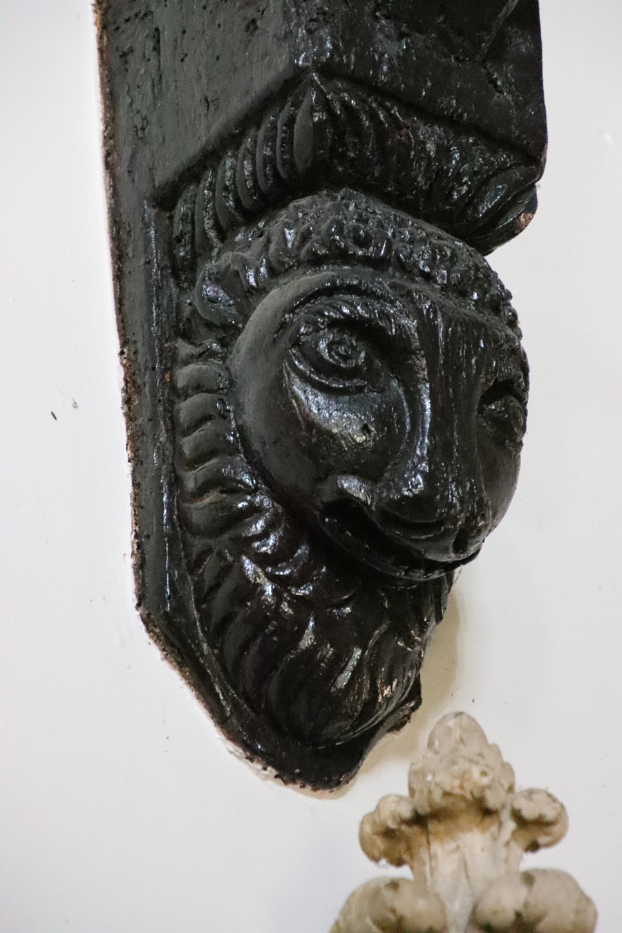


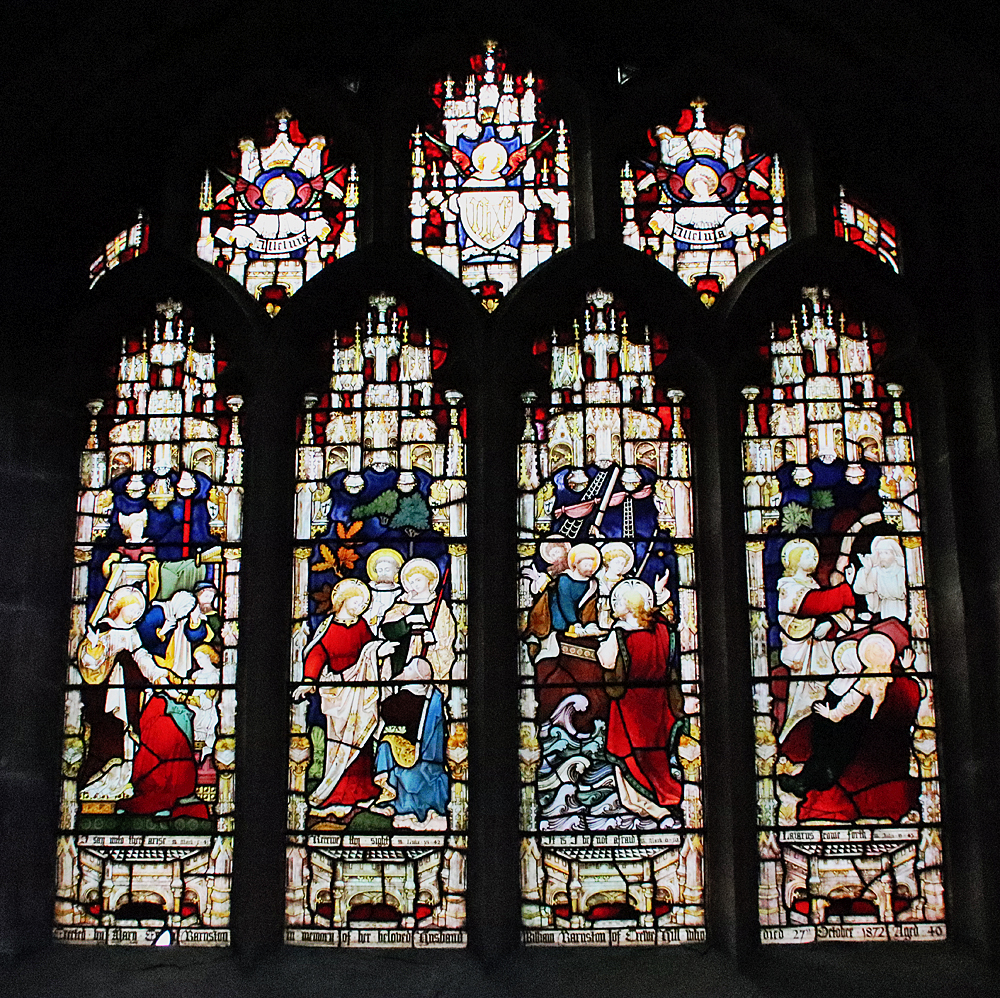
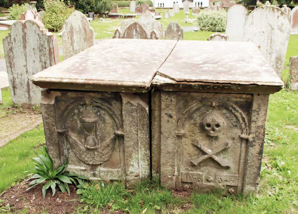 West ends of tombs have recessed round-headed panels; that to north contains an hourglass, that to south a skull and crossbones above an inscription Mors S… Omnium [i.e. Mors Sola Omnia,” meaning Death Conquers All]. North side of north tomb has a square central panel containing an encircled quatrefoil in a lozenge with a vertical panel right and a decayed panel left. The east end of each tomb has a fielded panel; south side of south tomb has 3 fielded panels in bolection moulded borders (Historic England – list entry number 1228746)


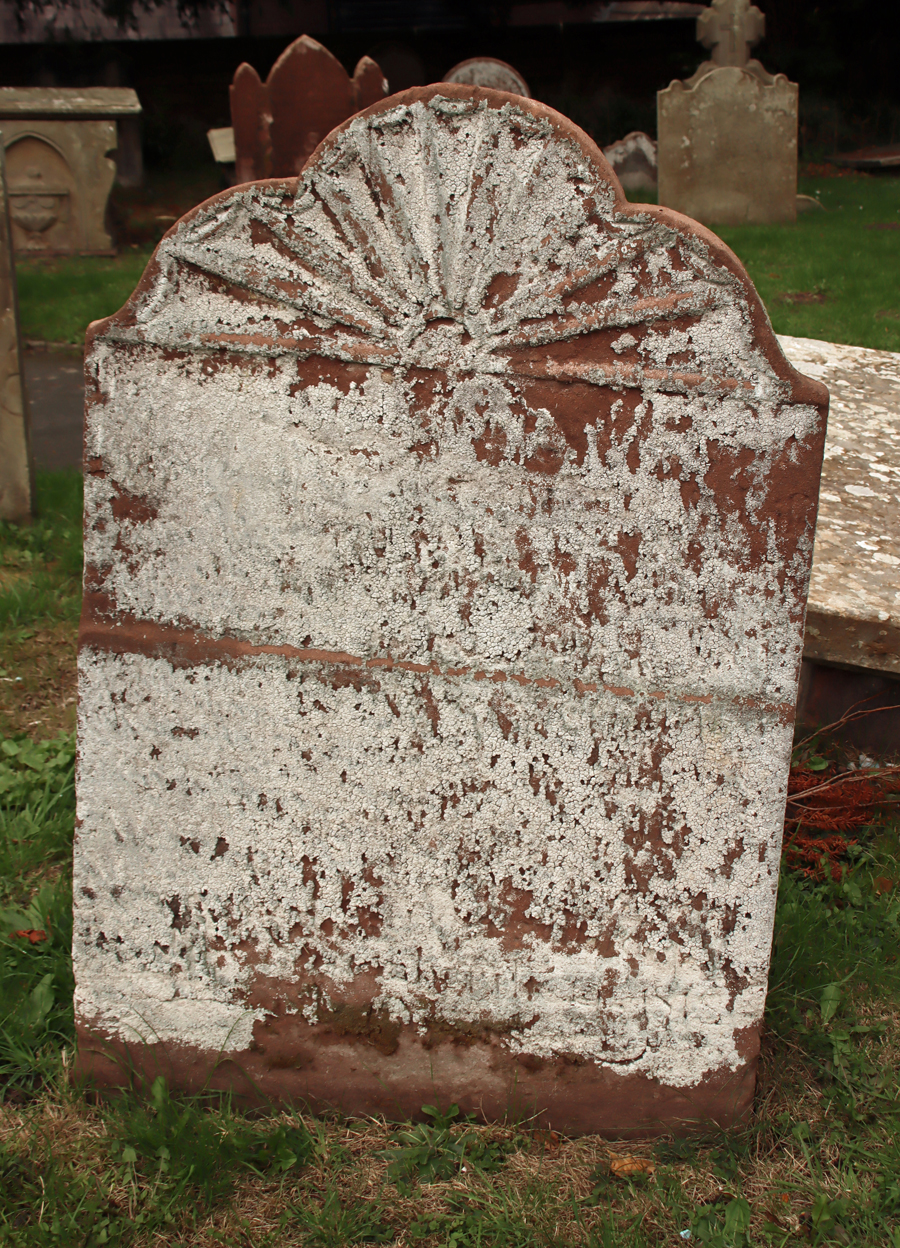


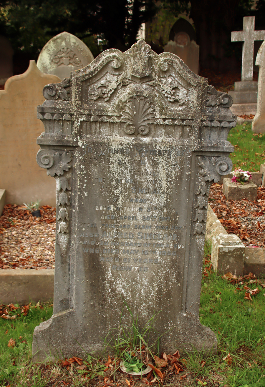
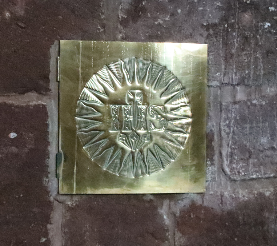 This medieval church, almost completely rebuilt in the 17th century, has a character of its own, reflecting various periods of restoration and intended improvement, with a strong gothic influence throughout. There are many more features than those described above, including benefaction boards, a list of incumbents, and memorials, and the church booklet produced by Cheshire County Council in 1989 is a good guide.
 Cheshire County Council 1989. The Parish church of St Chad, Farndon. (10-page booklet available for purchase at the church)


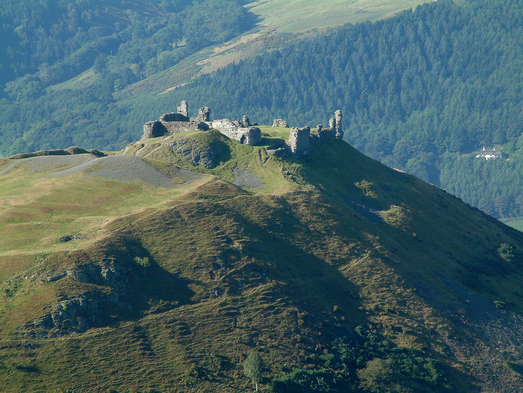


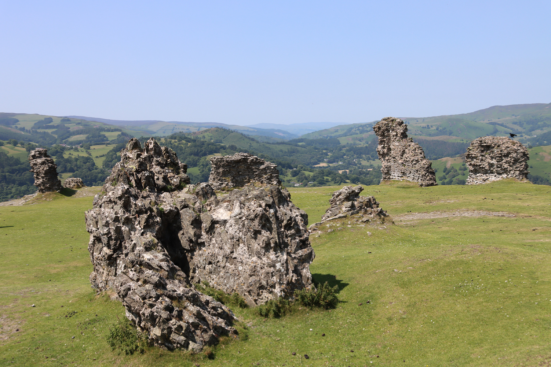


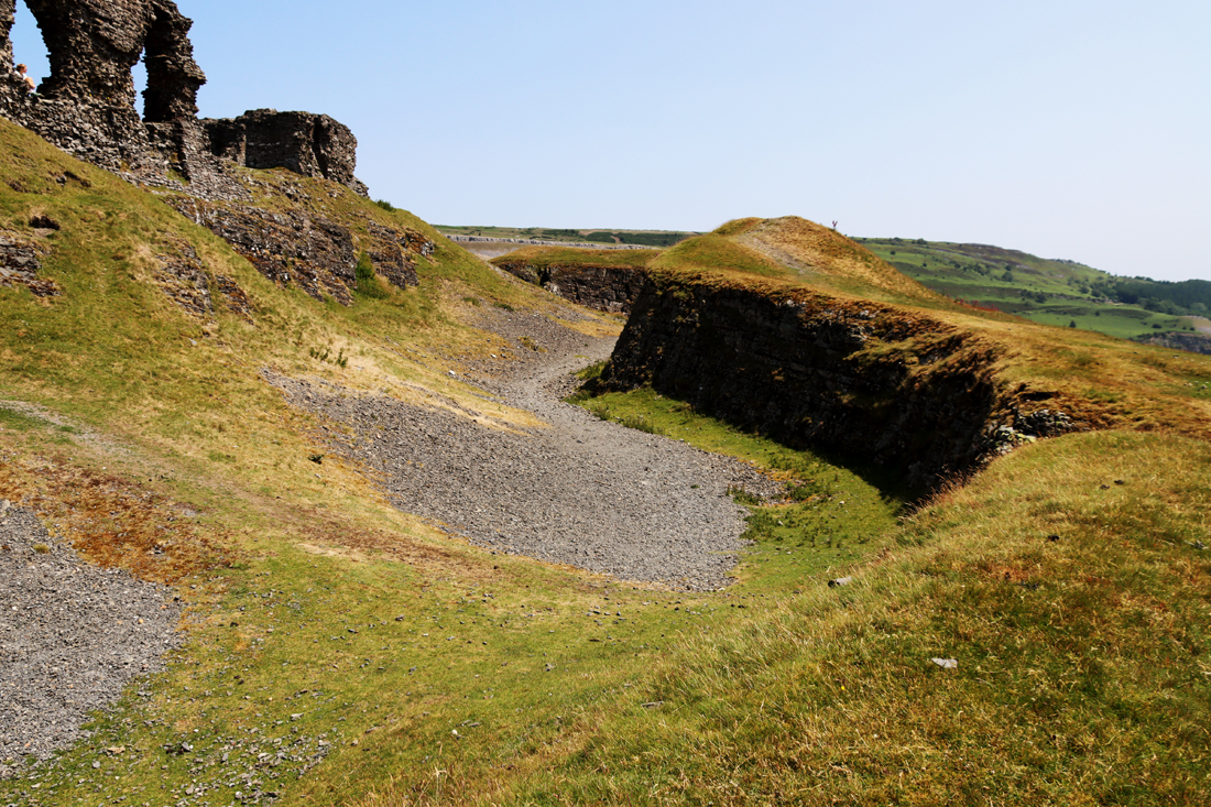


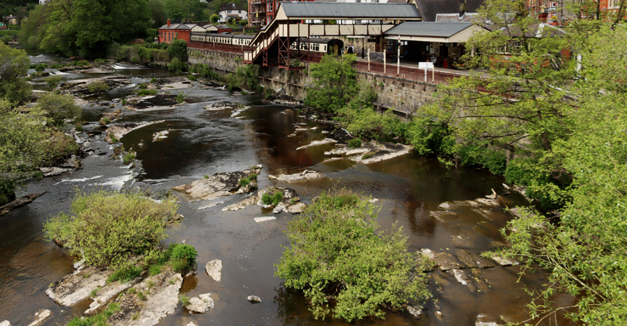


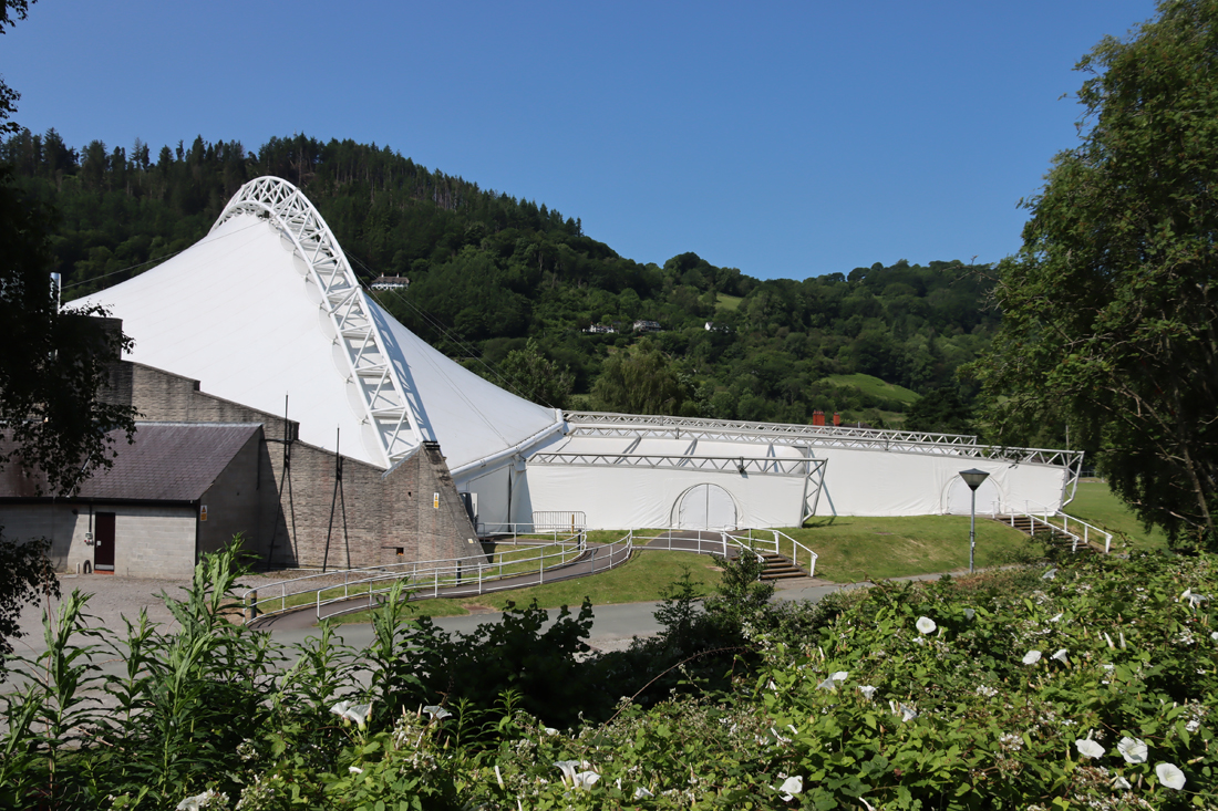


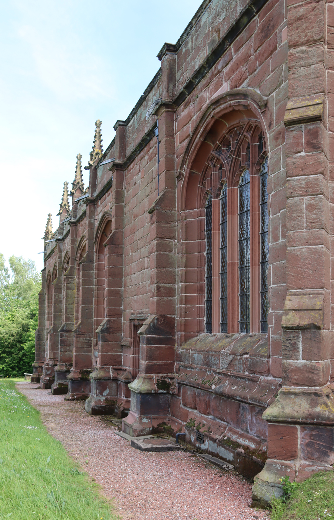


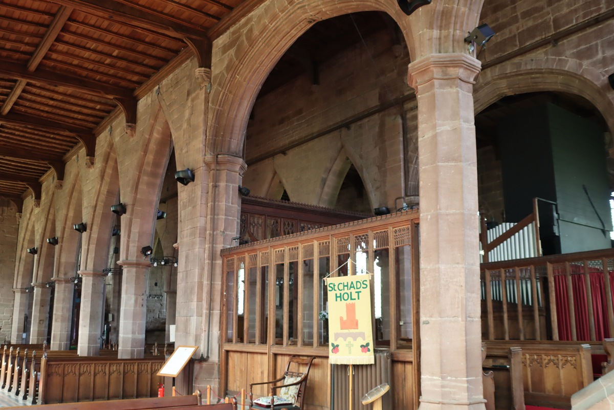


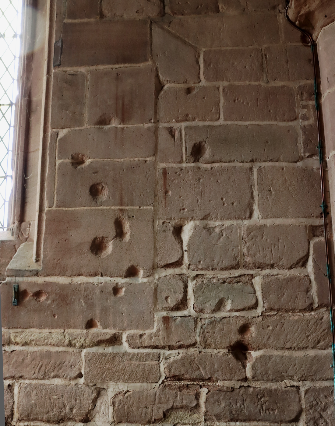


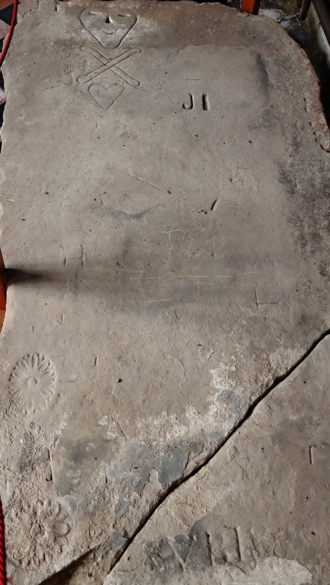

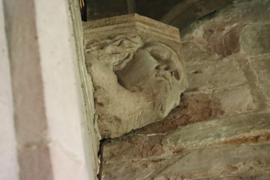


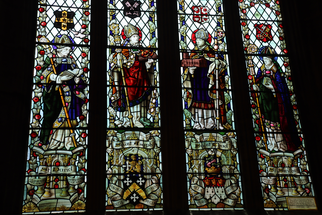


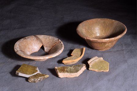


#/media/File:1837-42-Sir_William_Stanley.png)
_-_Google_Art_Project.jpg)