
This post is divided into two. Part 1 (this part) looks in brief at some of the history of the Chester city canals, mainly to untangle the complicated story of what is happening at the Tower Wharf Basin, where the Chester and Ellesmere Canals came together. Part 2 is a mainly photographic account of the walk along the canals from the river Dee to the Chester Boughton Hall Cricket Club, just beyond Tarvin Bridge.
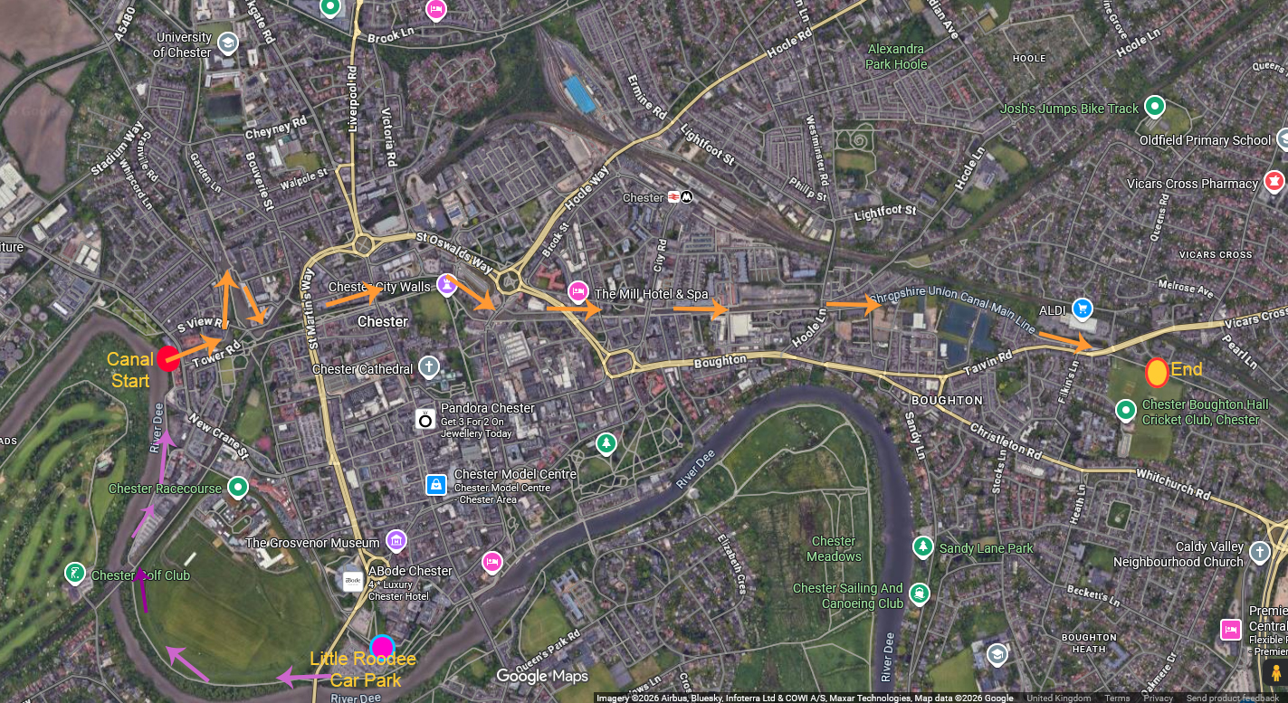
The pink arrows are my route from the Little Roodee car park to the start of the canal. The orange arrows are the route taken from the start of the canal at the river Dee to Chester Boughton Hall Cricket Club. Details of the walk are in Part 2.
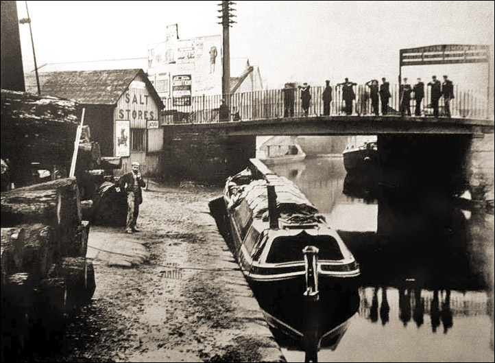
Cow Lane Bridge in the 1880s. Source: chesterwallsinfo
This post begins with a short description of the history of the Shropshire Union Canal, describes why the intersections just beyond the Northgate staircase lock is so complicated, and goes on to describe the walk.
The Shropshire Union Canal runs today from the Mersey and the Manchester Ship Canal at Ellesmere Port, to Autherley Junction near Wolverhampton on the Staffordshire and Worcestershire Canal over a distance of 66.5 miles (107km). Because it runs beyond the city walls, only making its presence felt to tourists where it crosses Northgate and along the base of the city walls, it does not feature on the city’s usual tourist routes. Unlike Chester’s well known medieval, Georgian and Victorian architectural attractions, the canal is more directly a component part of the city’s industrial past, but is just as essential in the city’s story.
The history of the Shropshire Union Canal
 During the 18th century civil engineer James Brindley (1716-1772) was responsible for building over 365 miles of canals. Brindely realized that any inland waterway network would need to connect to all the great navigable rivers that connected to the sea, including the Thames, the Mersey, the Severn and the Trent, incorporating other important navigable rivers like the the Avon and the Dee. The network was a sprawling affair, but it revolutionized transport, avoiding roads that would become mired and impassable in winter, as well as unnavigable sections of rivers, and the riverine problems of tides, drought and flood. Water into and out of the canal system was regulated and therefore predictable, and allowed year-round transport. The advantages became very clear very quickly, and manufacturing and trading businesses began to locate themselves at critical points on the canal network. Eagerness to invest in infrastructure resulted in a canal boom in the mid to late 1700s. Each new section of canal required an Act of Parliament, subject to Royal Assent, and Act after Act was passed as the network expanded.
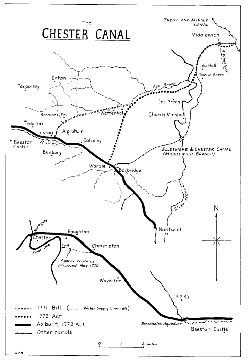
The Chester Canal. Source: Shearing 1985, p.150
The execution of the canal project for Chester was deeply flawed. Jumping on the canal bandwagon, entrepreneurs and investors envisaged a money-making venture that would bring Shropshire and Cheshire into the mainstream trade network with Birmingham, the nation’s canal hub and centre of industry, via a junction at Middlewich with the 1777 Trent and Mersey Canal. Unfortunately, the builders of the Chester Canal did not have agreements in place to connect their new Chester Canal either to the Trent and Mersey Canal, which denied them permission to build a junction, or with the River Dee Company, which also put barriers in their way leading to several years of negotiation before a satisfactory solution was reached. The Chester Canal, opening in 1779, was not built to Middlewich, where it had been planned for the Chester to join the Trent and Mersey, and instead stopped at Nantwich, segregated from the rest of the national canal network. With little traffic carrying low-value cargoes, as well as a packet boat service, the canal was a fairly substantial failure. In 1787 the Beeston staircase locks collapsed and there were insufficient funds to pay for repairs. The Chester Canal hovered on the verge of bankruptcy.
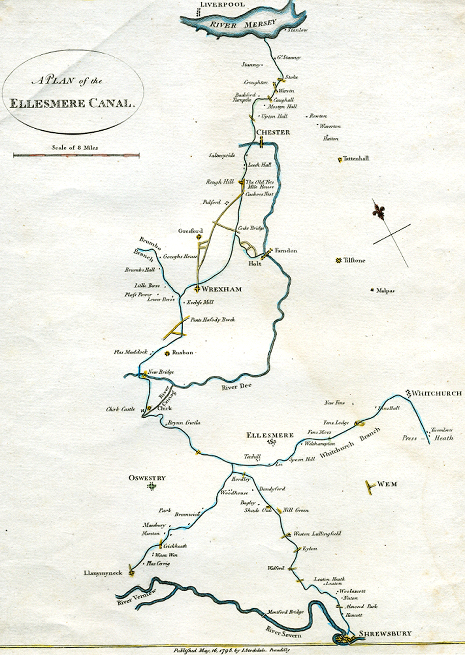
The complex arrangement of the Ellesmere Canal and its branches is shown as thin blue winding lines. The thick blue line from Chester is the Dee. The yellow lines are roads. Click to see a bigger version. Source: Wikipedia
If it had not been for the 1791 Ellesmere Canal project, the Chester Canal would not have managed to limp on much longer. The proposal for sections of canal to link the Mersey at Netherpool (now Ellesmere Port) to both the river Dee at Chester and the Severn at Shrewsbury was ambitious, but attracted sufficient support for a surveyor to be hired and possible routes to be explored. The Ellesmere Canal proposal was presented to parliament and received its Royal Assent in April 1793. Although shortages in funding prevented the realization of the full vision, shown right, Chester was at last brought into the national canal network. Part of this necessitated the addition of a new branch of canal from Chester to Ellesmere Port, which connected with the Chester Canal in what is now the Tower Wharf Basin. The two companies merged in 1813, becoming the Ellesmere and Chester Canal Companh. In 1833 the Middlewich branch was added, as the Chester Canal company had originally planned, and was connected to the rest of the network via the Trent and Mersey.
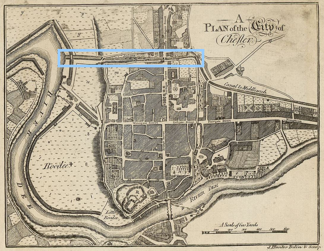
Hunter 1782 map with the canal before the basins were added for the Wirral Line
These changes required major infrastructure changes in Chester itself that are still clearly visible today. Starting from the former interface between the river and the canal, just off Sealand Road, the derelict remains of the river-canal lock are clearly visible as industrial archaeology. The gates have long gone and this section of the lock and the branch that once lead into the Dee Basin, along Tower Road on the map below, on its way to the Dee Branch, is full of aquatic plant life. As you walk along towards the Dee Branch, rounding the corner and passing under the bridge, you find yourself in the basin complex, the Ellesmere Canal Company’s solution to how best to incorporate the Wirral Line north to Ellesmere Port. However before the Ellesmere Canal Company was involved, the Chester Canal simply ran straight ahead, running directly along the Dee Basin into a set of five staircase locks before heading east towards Boughton.
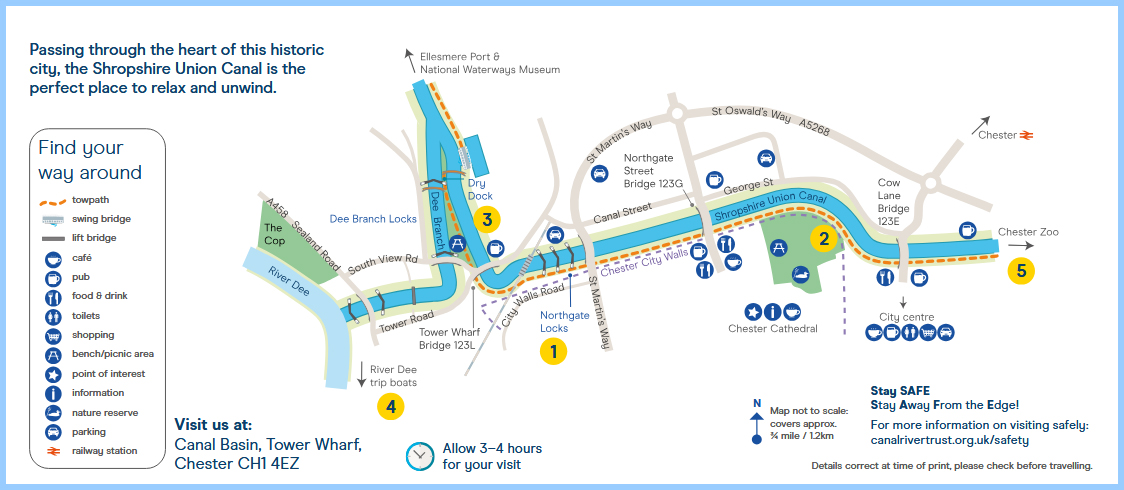
Canal and River Trust map of the basin and wharves, showing the complex arrangement of locks and basins required to incorporate the Wirral branch of the canal to Ellesmere Port.
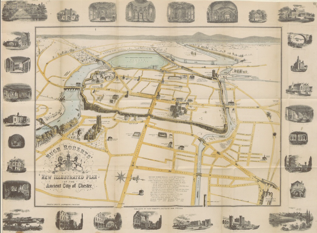
Map from the 1858 Roberts Chester Guide, showing the big Dee Basin at the far end where locks connected it to the Dee. Click image to enlarge
The set of basins and wharves that became necessary when the Chester Canal was incorporated into the Ellesmere Canal Company’s plans capture the fascinating history of how the area’s canal system was forced to evolve. Three different sections of the canal are involved in this complex arrangement, shown above. The earliest of these phases belongs to the original Chester Canal, which begins at the river Dee and once headed straight along into a series of five locks that climbed the hill to the dramatic sandstone cut and onwards to Hoole and Boughton before turning south to Christleton and beyond. The second phase is the Ellesmere Canal Company’s civil engineering work to incorporate the new “Wirral Line,” which headed in a roughly northerly direction out of Chester. This now chopped off the Chester Canal at the base of the locks, demolishing two of the five locks, to create the Tower Wharf Basin. The new arrangement cut off the canal from the river, meaning that another section of canal, called the Dee Branch, had to be created parallel to the main basin and accessed via a lock, to allow vessels to travel between the main line, the Wirral line and the Dee. It is not an elegant solution, but it worked. The rest of the canal is very straight forward as you walk towards Hoole, Boughton and beyond. The historical interest in those sections of the canal is more about the bridges and the flanking architecture that grew up around the canal.
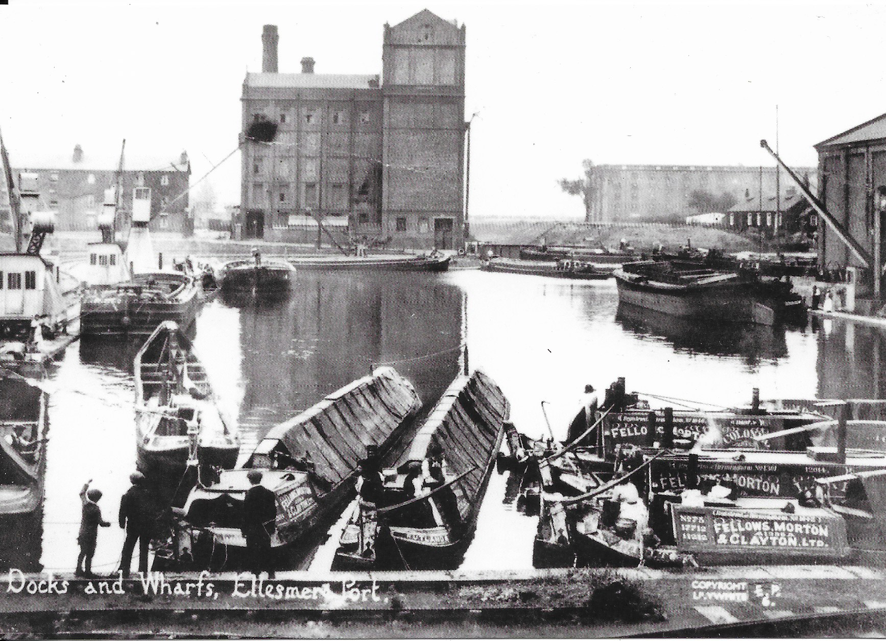
The docks and wharves at Ellesmere Port during the 19th century, from the Ellesmere Port canal museum archives
In 1846 the decision was made to bring together the various canal and railway interests together under one umbrella organization, the Shropshire Union Railways and Canals Company, providing the different sections of canal from Ellesmere Port to Wolverhampton with a single name: the Shropshire Union Canal. In 1894 the Manchester Ship Canal opened, and the Ellesmere Port access to the Mersey was now via the new shipping channel.
In spite of canalization of the Dee in the 1730s was intended to make the rapidly silting river navigable and to make Chester competitive once again with Liverpool, but in spite of these measures silting continued and the river became impractical for serious commercial shipping and shipbuilding, particularly in the face of Liverpool’s rapid expansion. The last ships were built on the Dee in the early 20th century, ending a centuries old industry, and the connection between the Shropshire Union and the river went out of use.
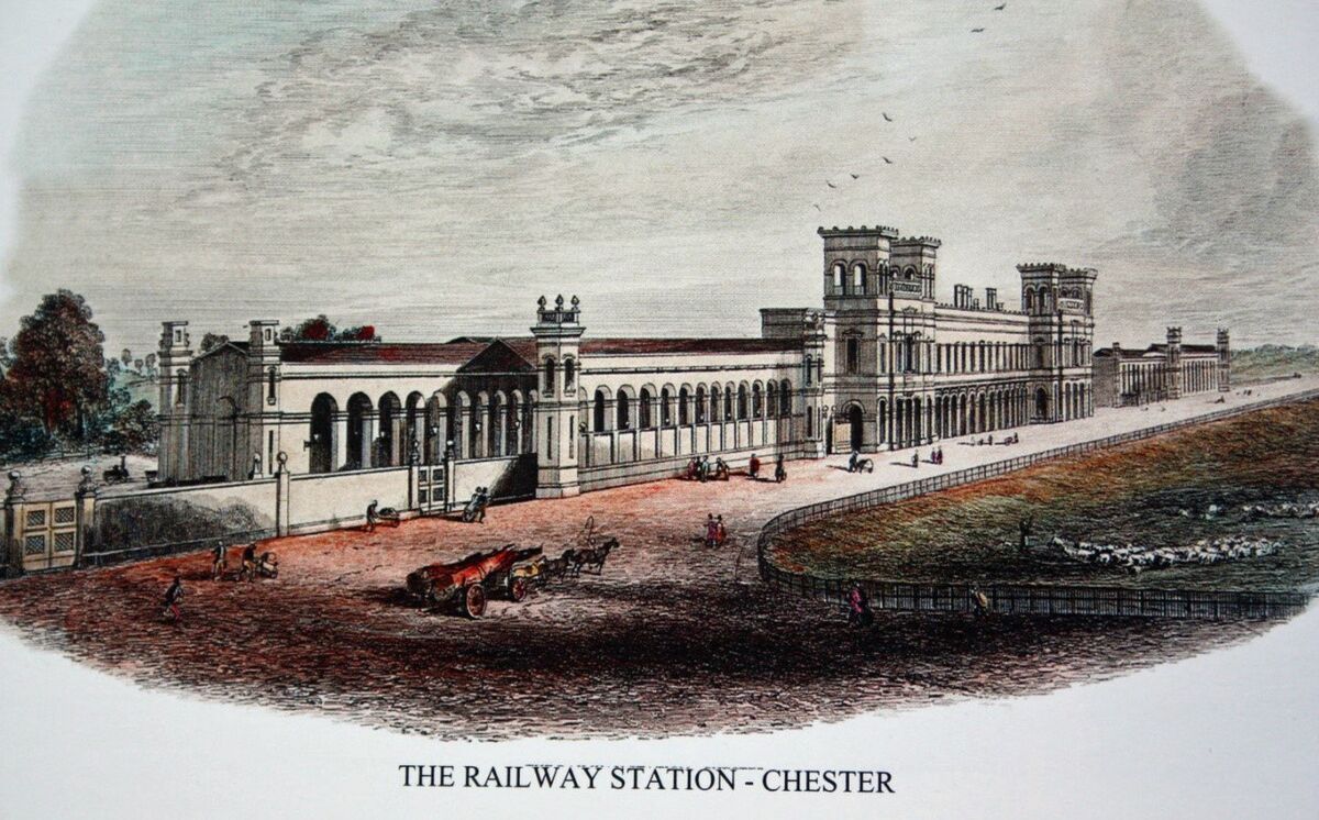
Chester Railway Station 1848. Source: Hoole History and Heritage Society
The railway came to Chester in 1840, picking up some of the slack, but Chester’s days as a centre for trade and industry were over and the main financial opportunity that the railway brought was tourism. The canal, however, continued to be used as part of the canal network, connecting to maritime trade via the Mersey. Eventually, as rail replaced the canals, many of them became derelict, only reviving as leisure resources in the later 20th century.
The canal attracted many businesses along its edges, and today the canal preserves a considerable amount of commercial and industrial heritage, adding a welcome extra dimension to Chester’s historic legacy. The canal network today is used for pleasure, mainly in the form of cruising, walking and cycling. It still covers a vast region of England and Wales and is managed by a mixture of state organizations and by both regional and local charities.
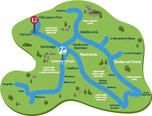
Schematic map showing how Chester relates to the canal network today. Source: Swanley Bridge Marina
As canals have become attractive for residential development, new housing has also been erected, some developments more sympathetic than others, but all interesting. The mixture is captured in the walk in Part 2. Apart from a few isolated examples, most of the warehousing that once flanked the basins and the canal has long gone, replaced by modern apartments, including student accommodation and retail outlets.
The Dee no longer connects to the canal network. The lock between the river and the Dee Branch of the canal, lying just over Sealand Road, is completely derelict. One of the locks further along is padlocked shut. The old swing bridge that had allowed vessels to interrupt road traffic to enter the canal network was replaced by the fixed road bridge in the 1960s. Today the leg of the Dee branch of the canal running parallel to the Basin, once used for access to the river, is used for mooring privately owned narrowboats.
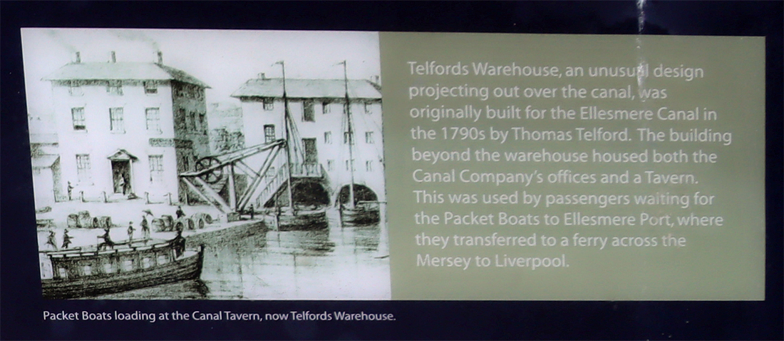
Signage at the canal basin showing information about Telford’s Warehouse
I have kept this history brief, merely to introduce the walk. Rather than reinventing the wheel, please see the Sources below, which contain much more information. The three video links also provide an excellent overview, between them, of the canal, its history, and some of the buildings and businesses associated with it. The first is by John Herson, one of whose guided canal walks I have done and thoroughly enjoyed, which focuses on Tower Wharf, the Canal Basin and the relationship of the canal with the Dee. The second is by Stuart Shuttleworth and looks at the main line of the canal as it passes through Chester. Together they form a brilliant introduction to the subject, showing the key places to visit. At the end, underneath Sources, there is another video by “Pastfinder,” which is longer and explores what remains today in more depth, walking and talking at the same time, making it quite easy to retrace his footsteps. There are some fascinating additional pieces of information in this.
John Herson:
Stuart Shuttleworth:
Sources:
A lot of information is contained in the two videos above and the one at the end of the post.
Other sources of information are as follows:
Books and papers
Carrington, Peter 1994. English Heritage Book of Chester. Batsford / English Heritage
Martin, Richard 2018. Ships of the Chester Rivers. Shipbuilding on the Dee from Chester to the Point of Ayr 1800-1942. Bridge Books
Mosse, J., David Lobband and Judith Pile 2023 (9th edition). Collins Nicholson Waterways Guide 4. Four Counties and the Welsh Canals. HarperCollins
Nicholson, R. 1989 (4th edition). Nicholson/Ordnance Survey Guide to the Waterways 2: Central. Robert Nicholson Publications and Ordnance Survey
Shearing, Edwin A. 1985. Chester Canal Projects: Part I. Journal of the Railway and Canal Historical Society. Vol XXVIII, no.3, November 1984. p.98-103
Shearing, Edwin A. 1985. Chester Canal Projects: Part II. Journal of the Railway and Canal Historical Society. Vol XXVIII, no.4, March 1985. p.146-154
Ward, Simon 2013 (2nd edition). Chester. A History. The History Press
Websites
Canal and River Trust
Welcome to Chester. Escape the city on this tranquil waterway (PDF)
https://canalrivertrust.org.uk/media/document/0z8YCnXdfYHg_am-LmUGSg/p22Wl115w_dWrQTRa-XYJd5Q5nl2UR6N17EY2G1JFyc/aHR0cHM6Ly9jcnRwcm9kY21zdWtzMDEuYmxvYi5jb3JlLndpbmRvd3MubmV0L2RvY3VtZW50Lw/0192bddd-4001-76ad-a95b-0ad3662ccdcc.pdf
Canal Routes
Chester Canal History
https://www.canalroutes.net/Chester-Canal.html
Chester Canal Route
https://www.canalroutes.net/Shropshire-Union-Canal.html#Chester-Canal-Route
Ellesmere Canal – Wirral Line
https://www.canalroutes.net/Shropshire-Union-Canal.html#Ellesmere-Canal-Wirral-Line
Shropshire Union Canal
https://www.canalroutes.net/Shropshire-Union-Canal.html
Cheshire West and Cheshire
Chester Canal Conservation Area Character Appraisal Ellesmere Port to Nantwich (PDF)
https://www.cheshirewestandchester.gov.uk/documents/planning-and-building-consultancy/total-environment/conservation-and-design/conservation-area-appraisals/canal-conservation-area-elesmere-port-to-nantwich-latest-version-261118.pdf
Chester Characterization Study
https://www.cheshirewestandchester.gov.uk/your-council/policies-and-performance/council-plans-policies-and-strategies/planning-policy/chester-characterisation-study
chesterwalls.info
Photographs of the Chester Canal Old and New, parts 1-5
https://chesterwalls.info/gallery/canalgallery.html
Chesterwiki
(with a lot of adverts interspersed)
Canalside
https://chester.shoutwiki.com/wiki/Canalside
Canal and Boatyard
https://chester.shoutwiki.com/wiki/Canal_and_Boatyard
Grace’s Guide to British Industrial History
James Brindley
https://www.gracesguide.co.uk/James_Brindley
William Jessop
https://www.gracesguide.co.uk/William_Jessop
Heritage Chester
Bite-Sized Wonder – The Lead Shot Tower
YouTube video
Historic England
Bridge of Sighs, Upper Northgate Street
https://historicengland.org.uk/listing/the-list/list-entry/1375967
Telfords Warehouse, Raymond Street
https://historicengland.org.uk/listing/the-list/list-entry/1375919?section=official-list-entry
Inland Waterways Association, Chester and Merseyside Branch
Chester Heritage Port Designation Document (PDF)
https://70cf2f03-3eb2-43c8-889f-b8f841fc3757.usrfiles.com/ugd/70cf2f_64e6633c34b9420f8c06a368857d1a42.pdf
UK Waterways Guide
Map of the Shropshire Union Canal
https://www.ukwaterwaysguide.co.uk/map/shropshire-union-canal/all-branches
“Pastfinder”:
