

Beautiful feathers on a bird of prey at Burton, Wirral
Yesterday seemed, at first, to have been doomed from the start. I was supposed to be driving to Aberdyfi in mid-Wales to do something specific, but 20 minutes from home, already running very late, realized that I had left two components essential to the task on the kitchen table. Having returned home and collected the required items, I was leaving the house and went to take a quick snapshot in my garden of a squirrel running upside down along a power line and rapidly closing on an oblivious turtle dove, and found to my dismay that the camera couldn’t read the SD card. Nooooooo! I knew I had a spare somewhere, but where? Ridiculous to go to Aberdyfi on a sunny blue-skied day like this without a camera. After half an hour of fruitless searching I picked up the phone and cancelled my visit. Twenty minutes later I had found the wretched thing. Instead of the planned expedition, I found myself grabbing the camera and car keys before heading up the Wirral to Burton to park up along the estuary and go for a very fine walk along part of the Wirral section of the King Charles III England Coast Path. I hadn’t even got out of the car when I saw the above bird of prey, which politely held position whilst I scrambled out of the car. A perfect way to turn around a very unpromising start to the day.
 I have made a short visit to the estuary cycle track and walk in the past, simply to get a good look at the purported Iron Age promontory fort on Burton Point, but although it was enjoyable, it was a short stroll because the skies opened and I got drenched. Today, with no risk of rain, I decided to walk from Burton towards Parkgate, which I guessed to be about an hour’s walk each way. When I reached the “You are Here” board (with which the walk is dotted at key points) at Moorside, alongside Parkgate Spring and on the very edge of Parkgate, this was a full hour.

Parking is easy along the section of Station Road that lies along the estuary for the Burton to Moorside (near Parkgate) section of the “King Charles III England Coast Path” (What3Words: ///glows.lung.headsets). Source: Google Maps
Parking for this particular walk is along the section of Station Road that runs along the side of the estuary, indicated by the red circle on the map.
The walk itself begins along the section of Denhall Lane that turns along the side of the estuary and passes a café, as indicated by the black arrow on the map. Although vehicles are permitted as far as the café (just beyond the left edge of the map), they are banned beyond this point.
 This first stretch of metalled lane is dominated by dog walkers and cyclists. Do keep an ear open for the cyclists as they can pick up a lot of speed along the lane and don’t always give a lot of notice of their impending arrival. The path goes through various changes. After some time it parts from the lane and becomes much more of a footpath with rough stone underfoot, which probably accounts for why the cyclists vanish from the scene at this point. At one stage it becomes a track across a field, although there is a route around this in wet weather that diverts inland for a while. The entire walk is well maintained with pedestrian gates and bridges where needed. One field had horses in it, so do take care if you are walking dogs.
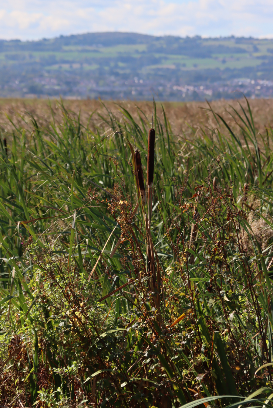
Scenically, the walk is always split between two different experiences to left and right. The views across both wetlands and former wetlands to the Welsh foothills to the southwest are lovely on a sunny day, and you can keep an eye open for bird life. On the other side of the path, immediately hugging its edges, there is an almost uninterrupted run of very fine hedgerows and trees. At this time of year there is not a great deal to see on the estuary, although I was delighted to see lovely white egrets in a distant blue pool, as well as a couple of birds of prey hovering splendidly overhead. Most of the flowers in the estuary have gone over, but the autumnal leaves, berries, rose-hips and other fruits of the shrubs and hedges and the multiple colours of the changing leaves on trees along the paths were endless and superb, really gorgeous against a blue sky with the sun shining on them.


xxx
 Nearing Neston I spotted a line of vast red sandstone blocks extending out into the estuary vegetation, and a small spur of land also extends out at this point. An information board explains that this is part of the Neston Colliery, Denhall Quay. There is a particularly good book about the collieries, The Neston Collieries, 1759–1855: An Industrial Revolution in Rural Cheshire (Anthony Annakin-Smith, second edition), published by the University of Chester, which I read and enjoyed a few years ago. The sandstone blocks are massive, and as well as retaining original metalwork, one of them has become a memorial stone, as has one of the trees on the small spur of land. The line of sandstone, now a piece of industrial archaeology, is a very small hint of the extensive work that once took place here, but is an important one. The author of the above-mentioned book refers to it in a short online page here, from which the following is taken:
There are still some signs today of the old mining operations. Most prominent is Denhall Quay, the remains of which still jut out into the Dee Estuary. This was built in 1791 and was used to ship coal to North Wales, Ireland and occasionally to foreign countries, as well as inland via newly-built canals. Also, if you know where to look it is possible to trace the location of many of the shafts that were once in use, including one hidden behind a brick wall in Riverside Walk. Easier and arguably more rewarding to find is The Harp Inn! The building was standing in the mines’ earliest days and records show it was a public house for the miners no later than 1813 and probably much earlier. It has several photos on its walls from the mines’ later days.

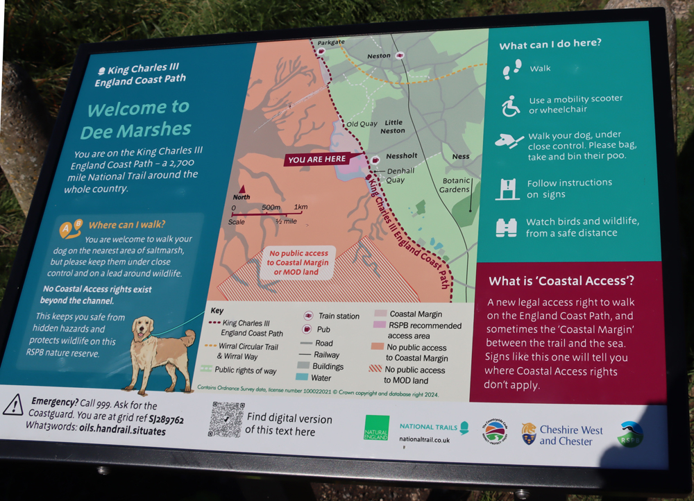


This is the point that I turned around and walked back. The image immediately above the map shows point where the Parkgate Spring emerges, very audible but not actually visible.


xxx
 There are very few places to sit down along the walk, so I would recommend that if you need to rest your legs occasionally, you take your own portable seating. Regarding refreshments, I have mentioned Net’s Café, near the Burton end. I haven’t visited and apparently there’s no website, but it is just off Denhall Lane and it is listed on Trip Advisor here. There is also a very good pub called The Harp, which I actually have visited, with outdoor tables immediately overlooking the wetlands towards the Welsh hills, just outside Little Neston. The food being served there looked excellent, and I can give a solid thumbs-up for the cider. The pub was particularly well situated for my return from Parkgate as the zoom lens on my camera, a particular beauty that has been worryingly on the twitch for weeks, suddenly stopped working and was now, just to ram home the overall message, rattling. A glass of cider and a seat in the sun were perfect for jury-rigging the wretched thing so that the zoom now worked like an old-fashioned telescope and the camera’s autofocus, which was refusing point-blank to engage in conversation with the lens, could be operated manually on the lens itself. Sigh. New lens on order.
If you can do this walk in September when the berries are at their best, do take the opportunity, because it is stunning, particularly on a sunny day. And all on the flat too, so entirely appropriate for unwilling legs.
xxx


