
 I have driven over the canal bridge on Eggbridge Lane in Waverton so many times thinking that I really must take advantage of the little car park just before the bridge to go and take a stroll down the towpath. Having woken up early on a sunny morning I decided to investigate. Waverton is just off the A41, so very easy to reach. The car park is quite small, but it was not full even on a bright and warm morning. The What3Words address for the car park is ///fingertip.snored.deals

Victoria Mill, Waverton
Immediately opposite the car park, as you walk to the towpath, is a very attractive canal building, the Grade 2 listed, a mid-19th century Victoria Mill, a former steam-powered canal-side corn mill, with bays for loading and unloading narrowboats, and now converted for modern use. The Historic England description is here. This is part of the heritage of the Shropshire Union Canal, which if you keep walking north eventually ends up at Ellesmere Port. To the south, it eventually connects up with the rest of the main canal network at Hurleston Junction. The Shropshire Union has quite a complicated history, as does Chester’s canal heritage as a whole, and was not completed until 1835.
 As with most canal walks, there’s always a choice to turn right or left, and as I had no idea what to expect from either direction I decided to head north, leaving the walk south for another occasion. Out of the car park I turned left under the unprepossessing bridge no.119 and headed up the towpath. This section is metalled, so it avoided the mud and sludge that I had been half expecting.
 If you take this route you find yourself walking along a short row of houses with canal gardens along a metalled pathway. Canal-side gardens are always fascinating. I used to live on a narrow boat many years ago, and it is always a lot of fun to see how different minds have dealt with a garden that opens directly on to a canal. These are always hugely individualistic and personal. There is always much to see in the way of garden furniture, garden ornaments (someone will always have gnomes, and there is usually at least one example of traditional canal painting), sheds in various states of repair, a wide range of summer houses, varieties of approaches to terracing, often some very interesting specimen trees and shrubs, and different attitudes to garden seclusion, along a spectrum from solid barriers of hedging or fencing to a complete lack of interest in any form of privacy. A real cultural treat.
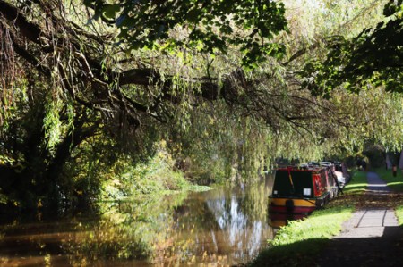
 After just a minute or so the towpath enters a more rural section, and in the late season sun it was a real pleasure to take in all the autumnal colours on trees and shrubs that flank the canal. I’ve posted some of the photos below. It’s a well-used section of towpath, with joggers, cyclists and plenty of dog walkers, but everyone is very civilized about moving over to make passing easy. There was not much in the way of canal traffic, with just two narrowboats on the move, but I expect that it is much busier in summer.
 Keep an eye out on your left as you leave the housing on your right and reach the more rural section. Partly concealed by the grass next to the towpath, there is a short inscribed red sandstone Parish Boundary Marker. This section of the canal passes through the parish of Rowton, famous for the Civil War Battle of Rowton Heath (see the Wikipedia entry on the subject and a more detailed analysis by Historic England). King Charles I is said to have watched his army lose that battle from the Phoenix Tower that still stands on Chester’s city walls. The stone marks the boundary between the parishes of Christleton (CP on the stone) and Rowton (RT). The date commemorates the date of the battle in 1645 and, below the level of the grass, 1995, the 250th anniversary of the battle.
===


 After this more countrified section there are more houses, all interesting, with some lovely weeping willows and other water-loving species, and a very attractive hump-backed bridge, that I have since discovered carries Rowton Bridge Road into Christleton. I walked up as far as The Cheshire Cat, which sensibly has a gate onto the towpath, and carried on just a short way beyond it, but at that point the canal converges closely with the A41 (Whitchurch Road) and it becomes quite a noisy experience with the unremitting traffic, especially during the week.
 Checking the map later (for example see the plotaroute.com website), I note that by coming off the towpath at Rowton Bridge it is possible to walk into the attractive village of Christleton, with its marvellous pond, and I would have done this had I realized. Another time. had to be somewhere else in the afternoon, so it was a short walk, probably an hour and a bit there and back at strolling pace, with pauses to let bicycles pass, and to take photographs.

 For those with unwilling legs (see the blog’s Introduction for details about what this refers to), the towpath heading north from Waverton is metalled, but quite uneven. No problem for most people, I would have thought but do keep an eye on it. There are places where the edges of the surface are particularly uneven, but this just means that if you are with someone else you need to go in single file for short sections. Otherwise, it’s on the flat and very enjoyable.
On the way back I followed the towpath beyond the car park for a few minutes to see how far the housing that backs onto the canal extended. This part of the towpath is not metalled, was muddy and is single-track. These houses and gardens are another interesting mixture – each of the sections of housing and gardens has its own personality, presumably reflecting both when it was built and the pricing. These look as though the garden-canal margins were all designed with narrowboats or other canal vessels in mind. There was indeed one narrowboat moored up at a garden. The housing stops after a couple of minutes and the towpath reverts to a far more rural appearance. I’ll investigate further on another day.


